


Matt’ Johnson
@tracktwentynine.bsky.social
gay. transportation planner. Dupont Circle resident. ATL native. Georgia Tech alum. Commissioner for SMD 2B06. 🏳️🌈🚲 Opinions my own. He/him

Northeast DC and northern Prince George's are served by Lines 7 & 9.
Line 7 is similar to our Green Line, but runs under Baltimore Ave through College Pk, Berwyn, Hollywood, & Beltsville.
Line 9 runs under Rhode Island Av via Mt Rainier and Hyattsville, with a cross-platform xfr at College Pk.
Line 7 is similar to our Green Line, but runs under Baltimore Ave through College Pk, Berwyn, Hollywood, & Beltsville.
Line 9 runs under Rhode Island Av via Mt Rainier and Hyattsville, with a cross-platform xfr at College Pk.

October 23, 2025 at 4:46 AM
Northeast DC and northern Prince George's are served by Lines 7 & 9.
Line 7 is similar to our Green Line, but runs under Baltimore Ave through College Pk, Berwyn, Hollywood, & Beltsville.
Line 9 runs under Rhode Island Av via Mt Rainier and Hyattsville, with a cross-platform xfr at College Pk.
Line 7 is similar to our Green Line, but runs under Baltimore Ave through College Pk, Berwyn, Hollywood, & Beltsville.
Line 9 runs under Rhode Island Av via Mt Rainier and Hyattsville, with a cross-platform xfr at College Pk.
Lines 3 and 7 serve Southeast DC and southern Prince George's.
Line 7 is similar to our IRL Green Line, but it follows Marion Barry Ave via Skyland and dips over to serve the Iverson Mall. It also continues south to Clinton.
Line 3 follows Pennsylvania Ave, Alabama Ave, & Marlboro Pike.
Line 7 is similar to our IRL Green Line, but it follows Marion Barry Ave via Skyland and dips over to serve the Iverson Mall. It also continues south to Clinton.
Line 3 follows Pennsylvania Ave, Alabama Ave, & Marlboro Pike.

October 23, 2025 at 4:43 AM
Lines 3 and 7 serve Southeast DC and southern Prince George's.
Line 7 is similar to our IRL Green Line, but it follows Marion Barry Ave via Skyland and dips over to serve the Iverson Mall. It also continues south to Clinton.
Line 3 follows Pennsylvania Ave, Alabama Ave, & Marlboro Pike.
Line 7 is similar to our IRL Green Line, but it follows Marion Barry Ave via Skyland and dips over to serve the Iverson Mall. It also continues south to Clinton.
Line 3 follows Pennsylvania Ave, Alabama Ave, & Marlboro Pike.
Here's downtown Fairfax City, where Line 2 dips down from I-66 at Nutley Street to serve Fairfax Circle, Fairfax, and Jermantown.
Line 6 from Alexandria provides a connection for commuters headed to jobs in that area.
Line 2 continues to Fair Oaks, which is also home to the Fairfax Co Gov't Ctr.
Line 6 from Alexandria provides a connection for commuters headed to jobs in that area.
Line 2 continues to Fair Oaks, which is also home to the Fairfax Co Gov't Ctr.

October 23, 2025 at 4:40 AM
Here's downtown Fairfax City, where Line 2 dips down from I-66 at Nutley Street to serve Fairfax Circle, Fairfax, and Jermantown.
Line 6 from Alexandria provides a connection for commuters headed to jobs in that area.
Line 2 continues to Fair Oaks, which is also home to the Fairfax Co Gov't Ctr.
Line 6 from Alexandria provides a connection for commuters headed to jobs in that area.
Line 2 continues to Fair Oaks, which is also home to the Fairfax Co Gov't Ctr.
In Tysons Corner, Line 3 runs under VA Route 7 between Seven Corners and Spring Hill. It does use the DTR median to get to the W&OD at Wiehle Avenue.
Line 10 (purple) serves the areas we know in IRL as Tysons and McLean stations.
Line 10 (purple) serves the areas we know in IRL as Tysons and McLean stations.

October 23, 2025 at 4:39 AM
In Tysons Corner, Line 3 runs under VA Route 7 between Seven Corners and Spring Hill. It does use the DTR median to get to the W&OD at Wiehle Avenue.
Line 10 (purple) serves the areas we know in IRL as Tysons and McLean stations.
Line 10 (purple) serves the areas we know in IRL as Tysons and McLean stations.
The Rosslyn-Ballston Corridor continues in my map, with Lines 2/3 running under Wilson Boulevard to Seven Corners then Broad Street to West Falls Church.
Note that the A Line runs in the median of I-66. In real life, VDOT bought the W&OD to use the ROW to build I-66. That used to be a rail line!
Note that the A Line runs in the median of I-66. In real life, VDOT bought the W&OD to use the ROW to build I-66. That used to be a rail line!

October 23, 2025 at 4:37 AM
The Rosslyn-Ballston Corridor continues in my map, with Lines 2/3 running under Wilson Boulevard to Seven Corners then Broad Street to West Falls Church.
Note that the A Line runs in the median of I-66. In real life, VDOT bought the W&OD to use the ROW to build I-66. That used to be a rail line!
Note that the A Line runs in the median of I-66. In real life, VDOT bought the W&OD to use the ROW to build I-66. That used to be a rail line!
Along Rockville Pike, compare my map with frequent stop-spacing to the IRL map, with fewer stations and an alignment closer to the B&O Railroad north of Twinbrook.
My map adds stations at Montrose Road, Edmonston Drive, Montgomery College, and Gude Drive.
My map adds stations at Montrose Road, Edmonston Drive, Montgomery College, and Gude Drive.


October 23, 2025 at 4:35 AM
Along Rockville Pike, compare my map with frequent stop-spacing to the IRL map, with fewer stations and an alignment closer to the B&O Railroad north of Twinbrook.
My map adds stations at Montrose Road, Edmonston Drive, Montgomery College, and Gude Drive.
My map adds stations at Montrose Road, Edmonston Drive, Montgomery College, and Gude Drive.
In Upper NW, Line 1 serves Adams Morgan under 18th Street, then switches to Connecticut Avenue, where it stays all the way to Chevy Chase Circle before angling toward Bethesda.
Line 8 serves Wisconsin Ave (including Tenleytown & Friendship Hts) between Georgetown and Bethesda.
Line 8 serves Wisconsin Ave (including Tenleytown & Friendship Hts) between Georgetown and Bethesda.

October 23, 2025 at 4:32 AM
In Upper NW, Line 1 serves Adams Morgan under 18th Street, then switches to Connecticut Avenue, where it stays all the way to Chevy Chase Circle before angling toward Bethesda.
Line 8 serves Wisconsin Ave (including Tenleytown & Friendship Hts) between Georgetown and Bethesda.
Line 8 serves Wisconsin Ave (including Tenleytown & Friendship Hts) between Georgetown and Bethesda.
Some areas of interest:
Old Town Alexandria, with the subway serving the core, rather than the periphery along the RF&P tracks. That space is instead used for the J Line. Potomac Yard service along Richmond Hwy.
Also note service to Oxon Hill and National Harbor on Line 8.
Old Town Alexandria, with the subway serving the core, rather than the periphery along the RF&P tracks. That space is instead used for the J Line. Potomac Yard service along Richmond Hwy.
Also note service to Oxon Hill and National Harbor on Line 8.

October 23, 2025 at 4:31 AM
Some areas of interest:
Old Town Alexandria, with the subway serving the core, rather than the periphery along the RF&P tracks. That space is instead used for the J Line. Potomac Yard service along Richmond Hwy.
Also note service to Oxon Hill and National Harbor on Line 8.
Old Town Alexandria, with the subway serving the core, rather than the periphery along the RF&P tracks. That space is instead used for the J Line. Potomac Yard service along Richmond Hwy.
Also note service to Oxon Hill and National Harbor on Line 8.
Here's downtown.
The Line 1 subway is similar to the Red Line, but runs under 18th and North Cap on either end.
The Line 2/3 subway is similar to the Orange Line, and Line 5/6 similar to the Yellow.
New subways under 14th/15th, Constitution, & M St NW & 2nd St NE/SE are added to the network.
The Line 1 subway is similar to the Red Line, but runs under 18th and North Cap on either end.
The Line 2/3 subway is similar to the Orange Line, and Line 5/6 similar to the Yellow.
New subways under 14th/15th, Constitution, & M St NW & 2nd St NE/SE are added to the network.

October 23, 2025 at 4:29 AM
Here's downtown.
The Line 1 subway is similar to the Red Line, but runs under 18th and North Cap on either end.
The Line 2/3 subway is similar to the Orange Line, and Line 5/6 similar to the Yellow.
New subways under 14th/15th, Constitution, & M St NW & 2nd St NE/SE are added to the network.
The Line 1 subway is similar to the Red Line, but runs under 18th and North Cap on either end.
The Line 2/3 subway is similar to the Orange Line, and Line 5/6 similar to the Yellow.
New subways under 14th/15th, Constitution, & M St NW & 2nd St NE/SE are added to the network.
Line J is a regional rail line using the W&OD from Dulles to Alexandria and the median of I-495 from Alexandria to Westphalia, then via MD Route 4 to Upper Marlboro (county seat of Prince George's County). It also acts as a circumferential line.

October 23, 2025 at 4:25 AM
Line J is a regional rail line using the W&OD from Dulles to Alexandria and the median of I-495 from Alexandria to Westphalia, then via MD Route 4 to Upper Marlboro (county seat of Prince George's County). It also acts as a circumferential line.
Line A is a regional rail line using the former W&OD railroad to run from Dulles Airport to Union Station via Reston, Vienna, and Rosslyn. Between Rosslyn and downtown, the line crosses the Potomac in the median of the Roosevelt Bridge and runs under Constitution Ave in a 4-track subway with Line 4.

October 23, 2025 at 4:22 AM
Line A is a regional rail line using the former W&OD railroad to run from Dulles Airport to Union Station via Reston, Vienna, and Rosslyn. Between Rosslyn and downtown, the line crosses the Potomac in the median of the Roosevelt Bridge and runs under Constitution Ave in a 4-track subway with Line 4.
Lines 10 & 20 are light rail lines running circumferentially.
Line 10 (purple) runs from Nutley Street to Lanham via Tysons, Bethesda, Silver Spring, Langley Park, Berwyn, and Greenbelt.
Line 20 (light blue) runs along I-495 from Lanham to Westphalia.
Line 10 (purple) runs from Nutley Street to Lanham via Tysons, Bethesda, Silver Spring, Langley Park, Berwyn, and Greenbelt.
Line 20 (light blue) runs along I-495 from Lanham to Westphalia.

October 23, 2025 at 4:21 AM
Lines 10 & 20 are light rail lines running circumferentially.
Line 10 (purple) runs from Nutley Street to Lanham via Tysons, Bethesda, Silver Spring, Langley Park, Berwyn, and Greenbelt.
Line 20 (light blue) runs along I-495 from Lanham to Westphalia.
Line 10 (purple) runs from Nutley Street to Lanham via Tysons, Bethesda, Silver Spring, Langley Park, Berwyn, and Greenbelt.
Line 20 (light blue) runs along I-495 from Lanham to Westphalia.
Line 9 (red) is a spur of Line 1 serving the Rhode Island Avenue and Baltimore Avenue corridors from Brentwood to College Park via Mount Rainier and Hyattsville.
Cross-platform transfer to Line 7 at College Park.
Cross-platform transfer to Line 7 at College Park.

October 23, 2025 at 4:19 AM
Line 9 (red) is a spur of Line 1 serving the Rhode Island Avenue and Baltimore Avenue corridors from Brentwood to College Park via Mount Rainier and Hyattsville.
Cross-platform transfer to Line 7 at College Park.
Cross-platform transfer to Line 7 at College Park.
Line 8 (pink) runs from National Harbor in the south to Westlake (Montgomery Mall) in the north passing Congress Heights, Riverfront, Capitol South, Union Station, Georgetown, the Wisconsin Avenue corridor, and Bethesda. Cross-platform transfers to the 2/3 at Georgetown and the 1 at Bethesda.

October 23, 2025 at 4:18 AM
Line 8 (pink) runs from National Harbor in the south to Westlake (Montgomery Mall) in the north passing Congress Heights, Riverfront, Capitol South, Union Station, Georgetown, the Wisconsin Avenue corridor, and Bethesda. Cross-platform transfers to the 2/3 at Georgetown and the 1 at Bethesda.
Line 7 (green) runs from Clinton-Woodyard along MD Route 5 in the south to Muirkirk Road in the north via Skyland, Anacostia, Navy Yard, Logan Circle, Columbia Heights, Petworth, Prince George's Plaza, College Park, and Beltsville.

October 23, 2025 at 4:16 AM
Line 7 (green) runs from Clinton-Woodyard along MD Route 5 in the south to Muirkirk Road in the north via Skyland, Anacostia, Navy Yard, Logan Circle, Columbia Heights, Petworth, Prince George's Plaza, College Park, and Beltsville.
Line 6 (yellow) runs from Fairfax City in the west, where it has a cross-platform transfer to Line 2, along Little River Turnpike via Annandale and Lincolnia to Old Town Alexandria, then along Line 5 northward. Trains terminate at Montgomery Hills north of Silver Spring.

October 23, 2025 at 4:14 AM
Line 6 (yellow) runs from Fairfax City in the west, where it has a cross-platform transfer to Line 2, along Little River Turnpike via Annandale and Lincolnia to Old Town Alexandria, then along Line 5 northward. Trains terminate at Montgomery Hills north of Silver Spring.
Line 5 (yellow) runs from Mount Vernon in the south to Norbeck in the north, via Old Town Alexandria, DCA, the 7th Street/Georgia Avenue corridor, Silver Spring, Wheaton, Glenmont, and Aspen Hill.

October 23, 2025 at 4:12 AM
Line 5 (yellow) runs from Mount Vernon in the south to Norbeck in the north, via Old Town Alexandria, DCA, the 7th Street/Georgia Avenue corridor, Silver Spring, Wheaton, Glenmont, and Aspen Hill.
Line 4 (blue) runs from Newington in the south to Largo in the east, serving downtown Springfield, Lincolnia, Columbia Pike, Rosslyn, the National Mall, Union Station, the H Street NE corridor, and the existing Blue Line corridor to Largo.

October 23, 2025 at 4:11 AM
Line 4 (blue) runs from Newington in the south to Largo in the east, serving downtown Springfield, Lincolnia, Columbia Pike, Rosslyn, the National Mall, Union Station, the H Street NE corridor, and the existing Blue Line corridor to Largo.
Line 3 (orange) starts at Herndon-Monroe P+R and runs along the W&OD and the DTR to Tysons, then along VA Route 7 through Falls Church, sharing with Line 2, then diverging at Potomac Avenue to serve SE DC, Forestville, and terminating at Westphalia, with connections to Line J and Line 20.

October 23, 2025 at 4:09 AM
Line 3 (orange) starts at Herndon-Monroe P+R and runs along the W&OD and the DTR to Tysons, then along VA Route 7 through Falls Church, sharing with Line 2, then diverging at Potomac Avenue to serve SE DC, Forestville, and terminating at Westphalia, with connections to Line J and Line 20.
Line 2 (orange) is similar to our IRL Orange Line. Main differences include routing under Wilson Boulevard (rather than I-66), serving downtown Fairfax City and Fair Oaks, and running under Annapolis Road instead of along the Northeast Corridor. Connection to the NEC takes place at Lanham.

October 23, 2025 at 4:07 AM
Line 2 (orange) is similar to our IRL Orange Line. Main differences include routing under Wilson Boulevard (rather than I-66), serving downtown Fairfax City and Fair Oaks, and running under Annapolis Road instead of along the Northeast Corridor. Connection to the NEC takes place at Lanham.
Line 1 (red) is similar to our real life (IRL) Red Line, but there are key differences, including more frequent stop spacing, alignment under streets rather than rail ROWs, & different termini.
In the northwest, the line heads to King Farm, Crown, and Kentlands.
In the northeast, to Burtonsville
In the northwest, the line heads to King Farm, Crown, and Kentlands.
In the northeast, to Burtonsville
October 23, 2025 at 4:05 AM
Line 1 (red) is similar to our real life (IRL) Red Line, but there are key differences, including more frequent stop spacing, alignment under streets rather than rail ROWs, & different termini.
In the northwest, the line heads to King Farm, Crown, and Kentlands.
In the northeast, to Burtonsville
In the northwest, the line heads to King Farm, Crown, and Kentlands.
In the northeast, to Burtonsville
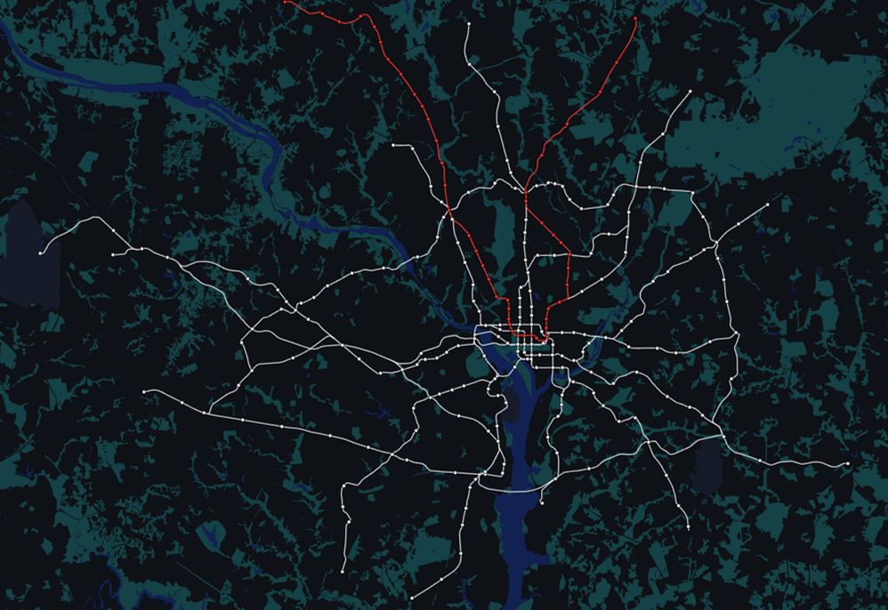
Let's meet the lines!
Metro lines are numbered 1-9 and are colored by one of their 5 downtown trunk routes. Six lines (1+9, 2+3, 5+6) share a downtown trunk.
Light rail lines are numbered 10 & 20 & run circumferentially.
Regional rail lines are lettered A & J (there are more in my naming scheme)
Metro lines are numbered 1-9 and are colored by one of their 5 downtown trunk routes. Six lines (1+9, 2+3, 5+6) share a downtown trunk.
Light rail lines are numbered 10 & 20 & run circumferentially.
Regional rail lines are lettered A & J (there are more in my naming scheme)

October 23, 2025 at 4:03 AM
Let's meet the lines!
Metro lines are numbered 1-9 and are colored by one of their 5 downtown trunk routes. Six lines (1+9, 2+3, 5+6) share a downtown trunk.
Light rail lines are numbered 10 & 20 & run circumferentially.
Regional rail lines are lettered A & J (there are more in my naming scheme)
Metro lines are numbered 1-9 and are colored by one of their 5 downtown trunk routes. Six lines (1+9, 2+3, 5+6) share a downtown trunk.
Light rail lines are numbered 10 & 20 & run circumferentially.
Regional rail lines are lettered A & J (there are more in my naming scheme)
The point above also means that in the case of a disruption, many lines have alternate paths through the network. If a track obstruction at Columbia Heights blocks the 7 (green), those trains can be rerouted onto the yellow trunk between Petworth & L’Enfant to bypass it.

October 23, 2025 at 3:47 AM
The point above also means that in the case of a disruption, many lines have alternate paths through the network. If a track obstruction at Columbia Heights blocks the 7 (green), those trains can be rerouted onto the yellow trunk between Petworth & L’Enfant to bypass it.
5. The downtown network should be scalable.
The trunk lines in downtown are designed to have connections so that the network can be phased in. The orange trunk can carry the 2 & 3 from Court House and also the 4 from Arlington Cemetery and the 8 from Glover Park. With growth, new trunks are added
The trunk lines in downtown are designed to have connections so that the network can be phased in. The orange trunk can carry the 2 & 3 from Court House and also the 4 from Arlington Cemetery and the 8 from Glover Park. With growth, new trunks are added


October 23, 2025 at 3:45 AM
5. The downtown network should be scalable.
The trunk lines in downtown are designed to have connections so that the network can be phased in. The orange trunk can carry the 2 & 3 from Court House and also the 4 from Arlington Cemetery and the 8 from Glover Park. With growth, new trunks are added
The trunk lines in downtown are designed to have connections so that the network can be phased in. The orange trunk can carry the 2 & 3 from Court House and also the 4 from Arlington Cemetery and the 8 from Glover Park. With growth, new trunks are added