


Thomas Larkin
@thomaslarkin.bsky.social
Assistant Professor at the University of Prince Edward Island. Historian of China and the U.S., specializing in global historical and digital methods.
References to British opium smuggling: 5; to Western opium smuggling: 3; to American opium smuggling: 0
Americans used the war to establish themselves as active agents in the drug trade. Surely there's some connection here to Xi's ire about Trump's claims that China is flooding the US with drugs...
Americans used the war to establish themselves as active agents in the drug trade. Surely there's some connection here to Xi's ire about Trump's claims that China is flooding the US with drugs...
October 29, 2025 at 2:18 PM
References to British opium smuggling: 5; to Western opium smuggling: 3; to American opium smuggling: 0
Americans used the war to establish themselves as active agents in the drug trade. Surely there's some connection here to Xi's ire about Trump's claims that China is flooding the US with drugs...
Americans used the war to establish themselves as active agents in the drug trade. Surely there's some connection here to Xi's ire about Trump's claims that China is flooding the US with drugs...
Choosing to read the potential increase in one dollar coin circulation as a sign Trump is warming to the U.S. becoming Canada's 4th territory.
October 3, 2025 at 6:35 PM
Choosing to read the potential increase in one dollar coin circulation as a sign Trump is warming to the U.S. becoming Canada's 4th territory.
🧵3/3
I've then combined the datasets so that all GPS points fall within the attributes table for the lots with which they align. The effect is that we can light up the lots that contain Carl Smith data and embed links to the archive, providing an alt. spatial/temporal means to search the index!
I've then combined the datasets so that all GPS points fall within the attributes table for the lots with which they align. The effect is that we can light up the lots that contain Carl Smith data and embed links to the archive, providing an alt. spatial/temporal means to search the index!

August 29, 2025 at 5:34 PM
🧵3/3
I've then combined the datasets so that all GPS points fall within the attributes table for the lots with which they align. The effect is that we can light up the lots that contain Carl Smith data and embed links to the archive, providing an alt. spatial/temporal means to search the index!
I've then combined the datasets so that all GPS points fall within the attributes table for the lots with which they align. The effect is that we can light up the lots that contain Carl Smith data and embed links to the archive, providing an alt. spatial/temporal means to search the index!
🧵2/3
Eric has also converted the dates into integer values so that we can isolate cards by date range, as many cover a few decades of history. I have then overlaid this data on the MHHK maps that fall within that date range (here's 1866).
Eric has also converted the dates into integer values so that we can isolate cards by date range, as many cover a few decades of history. I have then overlaid this data on the MHHK maps that fall within that date range (here's 1866).

August 29, 2025 at 5:34 PM
🧵2/3
Eric has also converted the dates into integer values so that we can isolate cards by date range, as many cover a few decades of history. I have then overlaid this data on the MHHK maps that fall within that date range (here's 1866).
Eric has also converted the dates into integer values so that we can isolate cards by date range, as many cover a few decades of history. I have then overlaid this data on the MHHK maps that fall within that date range (here's 1866).
The interns' primary role is to assist in creating a suite of georeferenced maps of Hong Kong from 1841-1997 using provided archival materials.
Their secondary role will be to enter data into selected maps from a variety of photographic and textual archival sources related to Hong Kong land use.
Their secondary role will be to enter data into selected maps from a variety of photographic and textual archival sources related to Hong Kong land use.
August 12, 2025 at 10:45 AM
The interns' primary role is to assist in creating a suite of georeferenced maps of Hong Kong from 1841-1997 using provided archival materials.
Their secondary role will be to enter data into selected maps from a variety of photographic and textual archival sources related to Hong Kong land use.
Their secondary role will be to enter data into selected maps from a variety of photographic and textual archival sources related to Hong Kong land use.
Candidates should have some background in late-19th/early-20th-century Chinese, British imperial, or colonial history, an interest in mapping, spatial history, and/or historical geography, and be in good academic standing. No prior experience with mapping software necessary.
August 12, 2025 at 10:45 AM
Candidates should have some background in late-19th/early-20th-century Chinese, British imperial, or colonial history, an interest in mapping, spatial history, and/or historical geography, and be in good academic standing. No prior experience with mapping software necessary.
"Mapping Historic Hong Kong explores how digital mapping tools and new technologies can be integrated with historical research to encourage urban heritage and an appreciation for histories of urban space and/or place, while benefiting both academic researchers and the wider public."
August 12, 2025 at 10:45 AM
"Mapping Historic Hong Kong explores how digital mapping tools and new technologies can be integrated with historical research to encourage urban heritage and an appreciation for histories of urban space and/or place, while benefiting both academic researchers and the wider public."
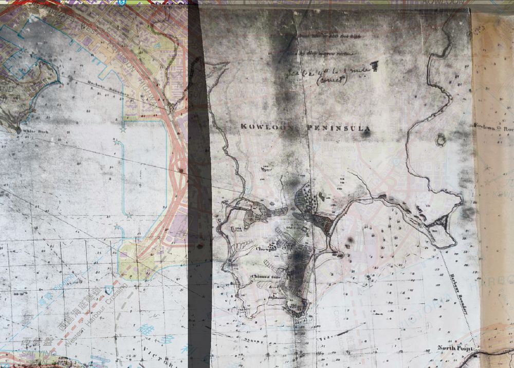
Kowloon also appears to have been a rush job or afterthought in many of these earlier maps. Its shoreline is highly approximate, requires a lot of manipulation, and no two maps that I've found from the era are quite the same in where they place things.
August 10, 2025 at 11:43 PM
Kowloon also appears to have been a rush job or afterthought in many of these earlier maps. Its shoreline is highly approximate, requires a lot of manipulation, and no two maps that I've found from the era are quite the same in where they place things.
These maps have given me MHHK's first territory map. Ordnance Mapping of mid-nineteenth century HK proved really accurate to a point, but precision fell away once coastlines get involved. The result is that the maps have been easy to centre, but very difficult to precisely align along the shore.
August 10, 2025 at 11:43 PM
These maps have given me MHHK's first territory map. Ordnance Mapping of mid-nineteenth century HK proved really accurate to a point, but precision fell away once coastlines get involved. The result is that the maps have been easy to centre, but very difficult to precisely align along the shore.
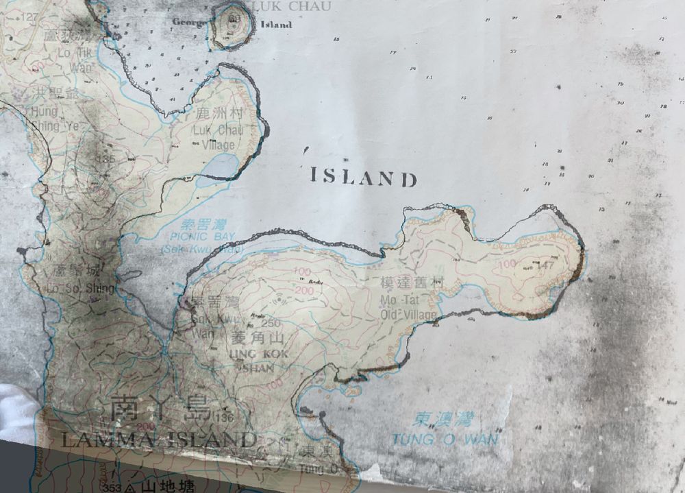
Coastline change, for comparison.
July 4, 2025 at 2:38 PM
Coastline change, for comparison.