


Stephen Mullens
@srmullens.bsky.social
Instructional Professor of Meteorology working to spin up a MET program at U Florida. I ask smart people dumb questions. #radar #tropics #summer
In the current NBA standings the bottom 6 teams in the west are 0-20 against the top 6 teams.
The season is only 15% complete, the top 6 is fluid, but someone will have to go lose the 9-10 game.
The season is only 15% complete, the top 6 is fluid, but someone will have to go lose the 9-10 game.

November 13, 2025 at 4:03 PM
In the current NBA standings the bottom 6 teams in the west are 0-20 against the top 6 teams.
The season is only 15% complete, the top 6 is fluid, but someone will have to go lose the 9-10 game.
The season is only 15% complete, the top 6 is fluid, but someone will have to go lose the 9-10 game.
bwahahaha. Calculated geostrophic wind speed of 275kts. Real wind was closer to 165kts.

November 11, 2025 at 5:20 PM
bwahahaha. Calculated geostrophic wind speed of 275kts. Real wind was closer to 165kts.
Such a pretty Rossby wave picking up Hurricane Melissa.


October 31, 2025 at 1:24 PM
Such a pretty Rossby wave picking up Hurricane Melissa.
The hurricane's more impactful right side is hitting the most well-constructed part of the country. This may keep the fatality rate, which will surely be high, lower than otherwise. But it will also mean recovery will require international help.


October 28, 2025 at 2:16 PM
The hurricane's more impactful right side is hitting the most well-constructed part of the country. This may keep the fatality rate, which will surely be high, lower than otherwise. But it will also mean recovery will require international help.
NHC official position update, with an updated central pressure as well.

October 28, 2025 at 1:10 PM
NHC official position update, with an updated central pressure as well.
If your students launch a weather balloon on Saturday, you are free to use the data for a homework assignment on Monday. Those are the rules. 🤣

October 27, 2025 at 4:39 PM
If your students launch a weather balloon on Saturday, you are free to use the data for a homework assignment on Monday. Those are the rules. 🤣
The AMS Gator Chapter launched their 4th weather balloon last night from Gainesville. Balloon made it to 11.8hPa and 30,001ft. Maybe next time we’ll top the club 3.76hPa record. Proud faculty advisor.


October 26, 2025 at 11:41 AM
The AMS Gator Chapter launched their 4th weather balloon last night from Gainesville. Balloon made it to 11.8hPa and 30,001ft. Maybe next time we’ll top the club 3.76hPa record. Proud faculty advisor.
The circle forecast.

October 21, 2025 at 3:12 PM
The circle forecast.
Just an 85kt subgeostrophic wind off the California coast.

October 15, 2025 at 2:28 AM
Just an 85kt subgeostrophic wind off the California coast.
Is the Atlantic season ACE ahead of average, about average, or behind average? A study in choosing what historical period to compare to, also known as lying with statistics to support what you want.


October 8, 2025 at 9:04 PM
Is the Atlantic season ACE ahead of average, about average, or behind average? A study in choosing what historical period to compare to, also known as lying with statistics to support what you want.
At least as far as effective landfalls go, Imelda is only the third landfalling storm this year following Barry and Chantel. And it will turn out that not all I-storms are big baddies.

September 28, 2025 at 11:17 PM
At least as far as effective landfalls go, Imelda is only the third landfalling storm this year following Barry and Chantel. And it will turn out that not all I-storms are big baddies.
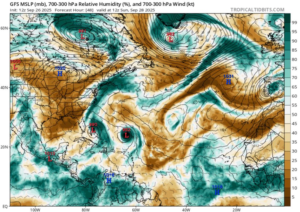
In this solution, the TC doesn't strengthen because the shear is displacing the rain to the north. But the divergence in that area keeps that convective area strong as the storm approaches the coast.
September 26, 2025 at 7:20 PM
In this solution, the TC doesn't strengthen because the shear is displacing the rain to the north. But the divergence in that area keeps that convective area strong as the storm approaches the coast.
This divergence is a result of both changes in jet curvature east of the trough (sub to super-geostrophic wind) and from the wind accelerating into the jet streak (4-quadrant model). In fact, this seems to be a situation where the jet streak is the greater influence of the two.


September 26, 2025 at 7:20 PM
This divergence is a result of both changes in jet curvature east of the trough (sub to super-geostrophic wind) and from the wind accelerating into the jet streak (4-quadrant model). In fact, this seems to be a situation where the jet streak is the greater influence of the two.
The jet stream and 93L interaction in two days will lead to a lot of upper-level divergence on the north side of the storm. These are calculations from GFS data. 🧵

September 26, 2025 at 7:20 PM
The jet stream and 93L interaction in two days will lead to a lot of upper-level divergence on the north side of the storm. These are calculations from GFS data. 🧵
In our current 30-year climatological period (1991-2020), the Atlantic is tied for the record low number of hurricanes to date. Neat, but nothing to scream about.
If you look at just the last 30 years (1995-2024), this is the longest the Atlantic has gone without 2 hurricanes.
smoothedweather.com
If you look at just the last 30 years (1995-2024), this is the longest the Atlantic has gone without 2 hurricanes.
smoothedweather.com


September 19, 2025 at 2:19 PM
In our current 30-year climatological period (1991-2020), the Atlantic is tied for the record low number of hurricanes to date. Neat, but nothing to scream about.
If you look at just the last 30 years (1995-2024), this is the longest the Atlantic has gone without 2 hurricanes.
smoothedweather.com
If you look at just the last 30 years (1995-2024), this is the longest the Atlantic has gone without 2 hurricanes.
smoothedweather.com
Gabrielle is giving it another go tonight.

September 19, 2025 at 12:51 AM
Gabrielle is giving it another go tonight.
Teaching hand map analysis with upper air is just sadder than it was last year. It's harder to draw the ridge in the northwest if the data doesn't exist.

September 17, 2025 at 5:44 PM
Teaching hand map analysis with upper air is just sadder than it was last year. It's harder to draw the ridge in the northwest if the data doesn't exist.
Clearest graph I’ve seen about social media influence. This was cited by @gelliottmorris.com in his Strength in Numbers blog about political violence.
open.substack.com/pub/gelliott...
open.substack.com/pub/gelliott...

September 13, 2025 at 1:18 PM
Clearest graph I’ve seen about social media influence. This was cited by @gelliottmorris.com in his Strength in Numbers blog about political violence.
open.substack.com/pub/gelliott...
open.substack.com/pub/gelliott...
Epitome of false advertising!
(They are quite good though.)
(They are quite good though.)

September 11, 2025 at 10:11 PM
Epitome of false advertising!
(They are quite good though.)
(They are quite good though.)
The Atlantic tropical season has gone from ahead of to behind pace for progress in number of TCs and ACE. In the heart of the season, climatology has the most slope and any lull seems dramatic. Then again, climatology has that slope for a reason, right?
We'll take the pause; season ain't over.
We'll take the pause; season ain't over.


September 11, 2025 at 1:08 PM
The Atlantic tropical season has gone from ahead of to behind pace for progress in number of TCs and ACE. In the heart of the season, climatology has the most slope and any lull seems dramatic. Then again, climatology has that slope for a reason, right?
We'll take the pause; season ain't over.
We'll take the pause; season ain't over.
Chelsea FC micro-takes: The home Chelsea radio commentators couldn't believe the team was up 2-0 as they had played so poorly. But the stats were all in Chelsea's favor. We may never know the truth. smoothedweather.com/consideratio...

September 1, 2025 at 3:14 AM
Chelsea FC micro-takes: The home Chelsea radio commentators couldn't believe the team was up 2-0 as they had played so poorly. But the stats were all in Chelsea's favor. We may never know the truth. smoothedweather.com/consideratio...
Made a map of TC “shorties,” since I’d never seen one before. Mostly, the TCs either quickly make landfall or travel over cooler water. The tracks ending in the eastern Caribbean “graveyard” are notable, too. Red are this year’s 3 shorties so far.
smoothedweather.com/tropical/
smoothedweather.com/tropical/

August 28, 2025 at 11:26 AM
Made a map of TC “shorties,” since I’d never seen one before. Mostly, the TCs either quickly make landfall or travel over cooler water. The tracks ending in the eastern Caribbean “graveyard” are notable, too. Red are this year’s 3 shorties so far.
smoothedweather.com/tropical/
smoothedweather.com/tropical/
For fun, I include graphs that demonstrate the relationships between a location's pressure level height, height gradient, latitude, and wind speed in the real world. The physics works, but the nuances are worth exploring!
Hope everyone finds these helpful.
Hope everyone finds these helpful.

August 21, 2025 at 3:33 PM
For fun, I include graphs that demonstrate the relationships between a location's pressure level height, height gradient, latitude, and wind speed in the real world. The physics works, but the nuances are worth exploring!
Hope everyone finds these helpful.
Hope everyone finds these helpful.
Calculating divergence from these components has helped me realize 1) ridge/trough curvature typically creates more divergence than jet streak accelerations & 2) that divergence associated with the four-quadrant model doesn't extend nearly as far as I tend to imagine (seen here).


August 21, 2025 at 3:33 PM
Calculating divergence from these components has helped me realize 1) ridge/trough curvature typically creates more divergence than jet streak accelerations & 2) that divergence associated with the four-quadrant model doesn't extend nearly as far as I tend to imagine (seen here).