


@solomonseal.bsky.social
I’m a software developer with an interests in gardening, 3D printing, mapping / cartography, and various other things :)
Let me know if you have any questions, or if you would like the las file I used, it can be kind’ve difficult to find good lidar data
January 4, 2025 at 1:37 AM
Let me know if you have any questions, or if you would like the las file I used, it can be kind’ve difficult to find good lidar data
There is an awesome map club in Ballard!
This is the python script which got me started github.com/code-fabrik/..., but it wasn't able to handle the really large las file I had, so I had to update the sampling method. I forked it and uploaded my changes to a repo here github.com/solomonseale...
This is the python script which got me started github.com/code-fabrik/..., but it wasn't able to handle the really large las file I had, so I had to update the sampling method. I forked it and uploaded my changes to a repo here github.com/solomonseale...
GitHub - solomonsealed/las2stl: Easily generate 3D meshes from a Lidar point cloud
Easily generate 3D meshes from a Lidar point cloud - solomonsealed/las2stl
github.com
January 3, 2025 at 6:28 PM
There is an awesome map club in Ballard!
This is the python script which got me started github.com/code-fabrik/..., but it wasn't able to handle the really large las file I had, so I had to update the sampling method. I forked it and uploaded my changes to a repo here github.com/solomonseale...
This is the python script which got me started github.com/code-fabrik/..., but it wasn't able to handle the really large las file I had, so I had to update the sampling method. I forked it and uploaded my changes to a repo here github.com/solomonseale...
You could call this map “Rave in Eryri” or “Super Eisteddfod”
December 18, 2024 at 10:45 PM
You could call this map “Rave in Eryri” or “Super Eisteddfod”
Another beautiful map, well done!
May I ask where you get your lidar data from and what tools you use to process it?
I have a .laz I’m trying to convert to an .stl to 3D print. I’ve tried cloud compare and mesh lab but I’ve only had (limited) success with a python script
May I ask where you get your lidar data from and what tools you use to process it?
I have a .laz I’m trying to convert to an .stl to 3D print. I’ve tried cloud compare and mesh lab but I’ve only had (limited) success with a python script
December 18, 2024 at 10:38 PM
Another beautiful map, well done!
May I ask where you get your lidar data from and what tools you use to process it?
I have a .laz I’m trying to convert to an .stl to 3D print. I’ve tried cloud compare and mesh lab but I’ve only had (limited) success with a python script
May I ask where you get your lidar data from and what tools you use to process it?
I have a .laz I’m trying to convert to an .stl to 3D print. I’ve tried cloud compare and mesh lab but I’ve only had (limited) success with a python script
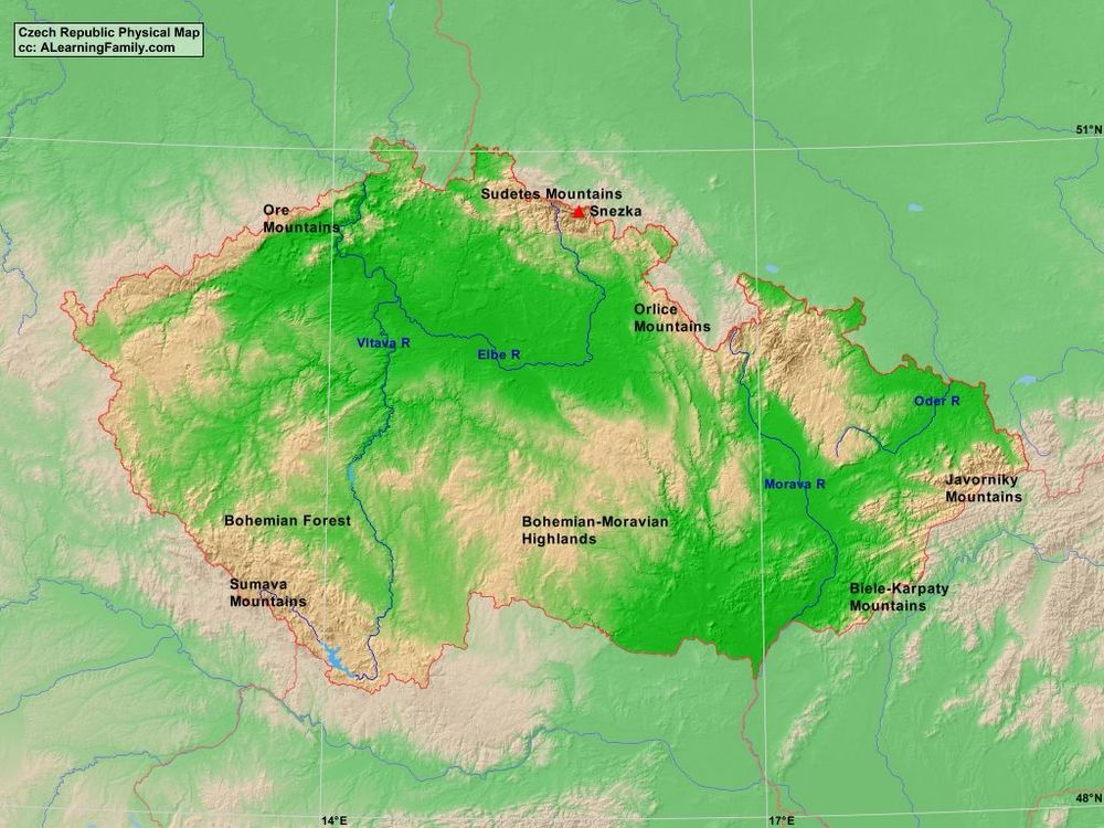
Topography of Czechia is interesting too. The Sudetes mountain range form a ring around the core of Czechia. The rough terrain is likely the reason for the high forest coverage, and why you also see high forest coverage in Alps, Carpathians, and Pyrenees.
December 16, 2024 at 10:22 PM
Topography of Czechia is interesting too. The Sudetes mountain range form a ring around the core of Czechia. The rough terrain is likely the reason for the high forest coverage, and why you also see high forest coverage in Alps, Carpathians, and Pyrenees.
Nice 3D monster portfolio, I just want some lidar data though
December 16, 2024 at 5:44 PM
Nice 3D monster portfolio, I just want some lidar data though
Fantastic map!
December 14, 2024 at 10:12 PM
Fantastic map!
He linked this in a previous post observablehq.com/@joewdavies/...
I like BlenderGIS a lot though which has elevation data and OSM
I like BlenderGIS a lot though which has elevation data and OSM
OpenStreetMap circles
Made with D3 and the Overpass API OSM data Helper functions Dependencies
observablehq.com
December 14, 2024 at 8:18 PM
He linked this in a previous post observablehq.com/@joewdavies/...
I like BlenderGIS a lot though which has elevation data and OSM
I like BlenderGIS a lot though which has elevation data and OSM
Nice expleriments, lots of nice green space and cool river, but no idea this city any hints?
December 14, 2024 at 8:12 PM
Nice expleriments, lots of nice green space and cool river, but no idea this city any hints?
I was in Cardiff this October. Had Welsh Caribbean fusion Jerk Lamb, and explored the castle. Charming map, recognized it right away :)
December 14, 2024 at 8:53 AM
I was in Cardiff this October. Had Welsh Caribbean fusion Jerk Lamb, and explored the castle. Charming map, recognized it right away :)
That is very interesting to see the expansion over time
December 13, 2024 at 9:57 PM
That is very interesting to see the expansion over time
Do you have lidar data for Rome? If not it will be hard to create a 3D replicate which I can print :)
December 13, 2024 at 6:02 PM
Do you have lidar data for Rome? If not it will be hard to create a 3D replicate which I can print :)
The gills on the left one are cool, do you know what type of mushroom it is?
December 13, 2024 at 5:15 AM
The gills on the left one are cool, do you know what type of mushroom it is?
Vivid red! 😍
December 13, 2024 at 5:09 AM
Vivid red! 😍