


Simon Gascoin
@sgascoin.bsky.social
bah le tweet a été supprimé ?
October 9, 2025 at 11:23 AM
bah le tweet a été supprimé ?
It seems that a human early warning system saved many lives "One of the shepherds, Wasiyat Khan from Rawshan village, was near the glacier when he used his mobile phone to alert the community about the impending flood." tribune.com.pk/story/256303... Pictures from www.linkedin.com/posts/melain...


August 25, 2025 at 2:13 PM
It seems that a human early warning system saved many lives "One of the shepherds, Wasiyat Khan from Rawshan village, was near the glacier when he used his mobile phone to alert the community about the impending flood." tribune.com.pk/story/256303... Pictures from www.linkedin.com/posts/melain...
High resolution image from Google Earth (July 2017) shows the catchment of the lake that collapsed in 2025

August 24, 2025 at 2:55 PM
High resolution image from Google Earth (July 2017) shows the catchment of the lake that collapsed in 2025
Before collapsing, the glacial lake was rapidly growing fed by snow melt.
August 24, 2025 at 2:52 PM
Before collapsing, the glacial lake was rapidly growing fed by snow melt.
You're right.. It's obvious when looking at the images in 3D
August 24, 2025 at 2:31 PM
You're right.. It's obvious when looking at the images in 3D
Yes, I had the same thoughts. Some downstream lakes look a bit bigger and the reason why the debris flow started there is unclear to me as well..
August 24, 2025 at 7:49 AM
Yes, I had the same thoughts. Some downstream lakes look a bit bigger and the reason why the debris flow started there is unclear to me as well..
August 24, 2025 at 1:25 AM
Great work - thanks for sharing!
June 1, 2025 at 9:11 PM
Great work - thanks for sharing!
Reposted by Simon Gascoin

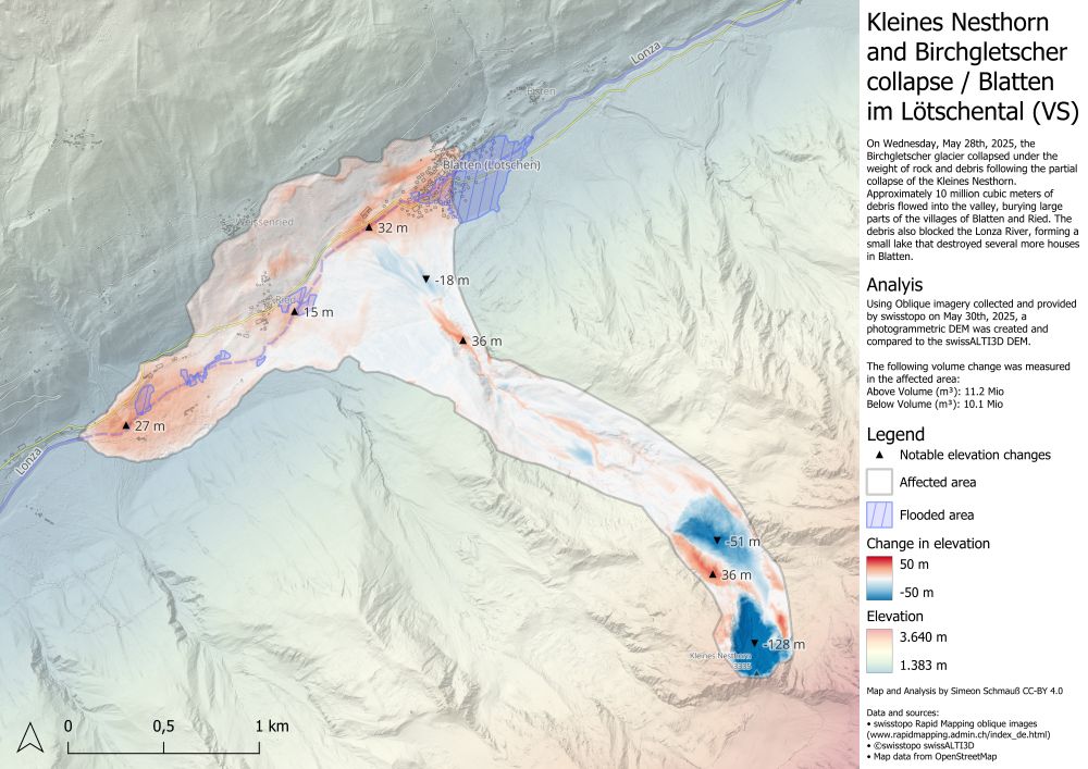
I also derived a new elevation model from the aerial images, allowing me to visualize the elevation change in the affected areas.
The rocks and debris in the valley are locally up to 32m thick and I estimate the total displaced volume is about 11 million cubic meters. #Blatten
The rocks and debris in the valley are locally up to 32m thick and I estimate the total displaced volume is about 11 million cubic meters. #Blatten
June 1, 2025 at 9:39 AM
I also derived a new elevation model from the aerial images, allowing me to visualize the elevation change in the affected areas.
The rocks and debris in the valley are locally up to 32m thick and I estimate the total displaced volume is about 11 million cubic meters. #Blatten
The rocks and debris in the valley are locally up to 32m thick and I estimate the total displaced volume is about 11 million cubic meters. #Blatten
Why? here its a strike-slip earthquake, the scenes are not cloudy and S2 offers a better spatial resolution than S1 for horizontal offset tracking.
April 3, 2025 at 8:51 AM
Why? here its a strike-slip earthquake, the scenes are not cloudy and S2 offers a better spatial resolution than S1 for horizontal offset tracking.