


Ryan
@ryanhanrahan.bsky.social
Meteorologist, Skier, Traveler (in no particular order).
Beast of a supercell heading into West Virginia with a huge TBSS and sidelobe spike.


April 14, 2025 at 9:02 PM
Beast of a supercell heading into West Virginia with a huge TBSS and sidelobe spike.
Impressive EFI signal this far out as well.

April 1, 2025 at 1:48 AM
Impressive EFI signal this far out as well.


High probability for excessive snowfall rates later this evening. Up to 2" per hour kind of rates around midnight for parts of Connecticut. Not a big storm but most of what we get will fall in a short window.


February 8, 2025 at 2:44 PM
High probability for excessive snowfall rates later this evening. Up to 2" per hour kind of rates around midnight for parts of Connecticut. Not a big storm but most of what we get will fall in a short window.
Just incredible. Congrats New Orleans!

January 20, 2025 at 10:01 PM
Just incredible. Congrats New Orleans!
Forecasting 1F at BDL tonight which would be the coldest night of the year! This will be the coldest night since February 4, 2023 (when it was -9F)!

December 22, 2024 at 9:16 PM
Forecasting 1F at BDL tonight which would be the coldest night of the year! This will be the coldest night since February 4, 2023 (when it was -9F)!
AirTag is in SLC but my skis are with me in Boston somehow! 🤷♂️

December 17, 2024 at 11:46 PM
AirTag is in SLC but my skis are with me in Boston somehow! 🤷♂️
53 knots at MVY from this one

December 12, 2024 at 3:41 AM
53 knots at MVY from this one
The low level jet has shifted east and with it the damaging wind threat is quite a bit lower here in CT. Some scattered power outages but overall it doesn't look like too big of a deal.

December 11, 2024 at 10:05 PM
The low level jet has shifted east and with it the damaging wind threat is quite a bit lower here in CT. Some scattered power outages but overall it doesn't look like too big of a deal.
Nice looking wind signature for tomorrow in Hartford with 56 knots at the top of the mixed layer!

December 11, 2024 at 4:03 AM
Nice looking wind signature for tomorrow in Hartford with 56 knots at the top of the mixed layer!
Obsessively checking model data before a ski trip is exhausting. At least @professorpowder.bsky.social has made some awesome graphics for it.

December 10, 2024 at 9:25 PM
Obsessively checking model data before a ski trip is exhausting. At least @professorpowder.bsky.social has made some awesome graphics for it.
Quite the low level jet overhead Wednesday PM. Strength of the low level inversion still a bit of a question but 50 knot gusts certainly seem possible for much of CT.

December 10, 2024 at 2:48 AM
Quite the low level jet overhead Wednesday PM. Strength of the low level inversion still a bit of a question but 50 knot gusts certainly seem possible for much of CT.
Cold Air Damming season is here!

December 9, 2024 at 10:46 PM
Cold Air Damming season is here!

Love this shot from Hartford of some really shallow fog right over the river. Could be some black ice in a few towns tonight with temperatures near 32F.

November 27, 2024 at 2:09 AM
Love this shot from Hartford of some really shallow fog right over the river. Could be some black ice in a few towns tonight with temperatures near 32F.
Close call in the NW Hills on Thursday for snow vs rain. The GFS is the coldest model and is borderline at best (925hPa temps ~0c) but it is close to some heavy, wet accumulation above 1,000ft. That said, other models like the NAM and Euro are much warmer and almost all rain.


November 27, 2024 at 1:42 AM
Close call in the NW Hills on Thursday for snow vs rain. The GFS is the coldest model and is borderline at best (925hPa temps ~0c) but it is close to some heavy, wet accumulation above 1,000ft. That said, other models like the NAM and Euro are much warmer and almost all rain.
A heavy, wet snowstorm on Thanksgiving is looking more likely for southern VT and maybe parts of the Berkshires too. Great news for Mount Snow and Stratton! ⛷️

November 26, 2024 at 1:59 AM
A heavy, wet snowstorm on Thanksgiving is looking more likely for southern VT and maybe parts of the Berkshires too. Great news for Mount Snow and Stratton! ⛷️
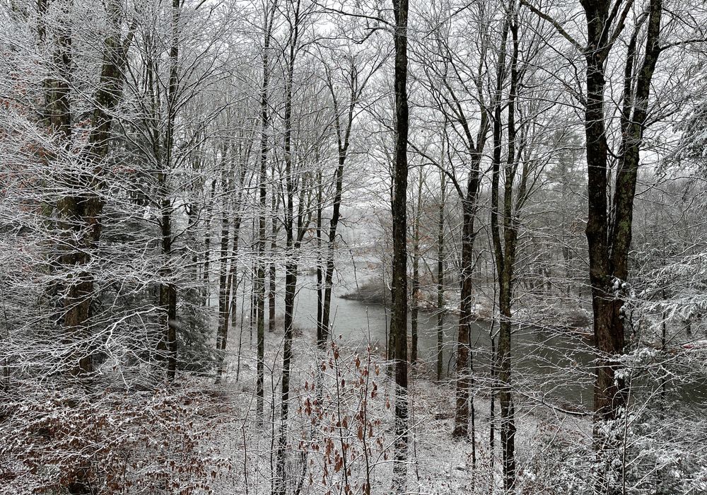
A beautiful picture of this morning’s snow from R. F. Wilton along the Bantam River in Litchfield County. A slushy inch or two fell overnight in parts of western Connecticut!
November 22, 2024 at 3:02 PM
A beautiful picture of this morning’s snow from R. F. Wilton along the Bantam River in Litchfield County. A slushy inch or two fell overnight in parts of western Connecticut!
Nice looking bright band over Long Island and only about 1kft up. Change to snow will happen quickly in parts of Fairfield County.

November 22, 2024 at 4:57 AM
Nice looking bright band over Long Island and only about 1kft up. Change to snow will happen quickly in parts of Fairfield County.
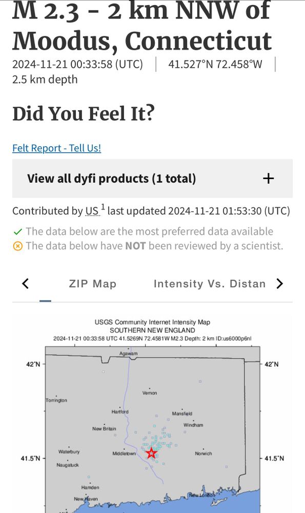
The Moodus Noises acting up tonight! Did you feel the quake?
November 21, 2024 at 2:00 AM
The Moodus Noises acting up tonight! Did you feel the quake?
Big signal on the ECWMF for a significant snow event in NE PA on Thursday. EFI >0.9 and a SOT of nearly 5. Could be a pretty narrow band of significant accumulation.

November 20, 2024 at 1:49 AM
Big signal on the ECWMF for a significant snow event in NE PA on Thursday. EFI >0.9 and a SOT of nearly 5. Could be a pretty narrow band of significant accumulation.
Really interesting setup on Friday. Cold advection from the south(!) and wrap around moisture will lead to a period of snow in parts of the state. Higher elevations in western CT favored.


November 19, 2024 at 9:12 PM
Really interesting setup on Friday. Cold advection from the south(!) and wrap around moisture will lead to a period of snow in parts of the state. Higher elevations in western CT favored.
GEFS showing good odds (25th to 75th percentile) of 0.75"-1.50" of precipitation for this week's storm. Typically this wouldn't be particularly excited but since September 1st we've only seen 1.30" of rain in the Hartford area!

November 19, 2024 at 3:17 PM
GEFS showing good odds (25th to 75th percentile) of 0.75"-1.50" of precipitation for this week's storm. Typically this wouldn't be particularly excited but since September 1st we've only seen 1.30" of rain in the Hartford area!
Incredible storm developing off the Pacific Northwest. WPC has the cyclone going sub-950 hPa. Highly anomalous even for a part of the world used to intense storms.


November 19, 2024 at 3:10 PM
Incredible storm developing off the Pacific Northwest. WPC has the cyclone going sub-950 hPa. Highly anomalous even for a part of the world used to intense storms.