


Robin Cole
@robmarkcole.bsky.social
Tackling the worlds toughest challenges with AI & ML applied to satellite & aerial imagery
https://www.satellite-image-deep-learning.com/
https://www.satellite-image-deep-learning.com/
Reposted by Robin Cole

Excited to share that the first paper of my PhD has been accepted for publication at the ISPRS Geospatial Week 2025! This dataset paper introduces a globally representative, high-resolution (10m) benchmark dataset for Above Ground Biomass estimation.


January 27, 2025 at 1:21 PM
Excited to share that the first paper of my PhD has been accepted for publication at the ISPRS Geospatial Week 2025! This dataset paper introduces a globally representative, high-resolution (10m) benchmark dataset for Above Ground Biomass estimation.
Reposted by Robin Cole
This is great stuff from Robin Cole and Marek Kraft
www.satellite-image-deep-learning.com/p/deepness-q...
www.satellite-image-deep-learning.com/p/deepness-q...

Deepness QGIS plugin
With Marek Kraft
www.satellite-image-deep-learning.com
December 19, 2024 at 10:45 PM
This is great stuff from Robin Cole and Marek Kraft
www.satellite-image-deep-learning.com/p/deepness-q...
www.satellite-image-deep-learning.com/p/deepness-q...
Prithvi-EO-2.0: A Versatile Multi-Temporal Foundation Model for Earth Observation Applications
github.com/NASA-IMPACT/...
github.com/NASA-IMPACT/...

December 5, 2024 at 12:49 PM
Prithvi-EO-2.0: A Versatile Multi-Temporal Foundation Model for Earth Observation Applications
github.com/NASA-IMPACT/...
github.com/NASA-IMPACT/...
Reposted by Robin Cole

🌍 How can AI transform hurricane forecasting?
NASA’s Prithvi AI model, built on decades of open data, is helping scientists uncover new insights about hurricanes while making forecasting more accessible to all.
🔗 Listen: www.nasa.gov/podcasts/cur...
#OpenScience #ClimateTech #DisasterResponse
NASA’s Prithvi AI model, built on decades of open data, is helping scientists uncover new insights about hurricanes while making forecasting more accessible to all.
🔗 Listen: www.nasa.gov/podcasts/cur...
#OpenScience #ClimateTech #DisasterResponse

November 25, 2024 at 10:46 PM
🌍 How can AI transform hurricane forecasting?
NASA’s Prithvi AI model, built on decades of open data, is helping scientists uncover new insights about hurricanes while making forecasting more accessible to all.
🔗 Listen: www.nasa.gov/podcasts/cur...
#OpenScience #ClimateTech #DisasterResponse
NASA’s Prithvi AI model, built on decades of open data, is helping scientists uncover new insights about hurricanes while making forecasting more accessible to all.
🔗 Listen: www.nasa.gov/podcasts/cur...
#OpenScience #ClimateTech #DisasterResponse
Reposted by Robin Cole

Reposted by Robin Cole

AI may sound more “natural” than how we, many of us, scientists speak.. am I too cynical to think that we could actually learn from this www.technologyreview.com/2024/10/03/1...

People are using Google study software to make AI podcasts—and they’re weird and amazing
NotebookLM is a surprise hit. Here are some of the ways people are using it.
www.technologyreview.com
November 24, 2024 at 7:23 AM
AI may sound more “natural” than how we, many of us, scientists speak.. am I too cynical to think that we could actually learn from this www.technologyreview.com/2024/10/03/1...
Reposted by Robin Cole

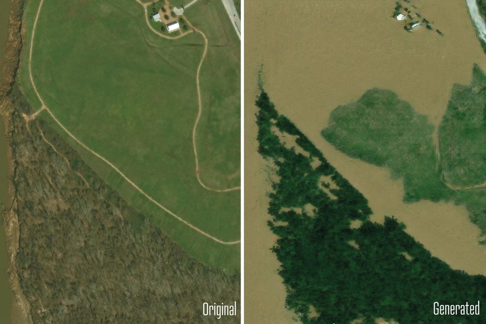
Here is an example of semantic segmentation of man-made structures (suburban housing in this case) with a FCN using UNET architecture. The houses missed were built after the GEE image was archived. See my shared COLAB notebook at
colab.research.google.com/drive/136YAV...
for the details.
colab.research.google.com/drive/136YAV...
for the details.

November 23, 2024 at 1:35 PM
Here is an example of semantic segmentation of man-made structures (suburban housing in this case) with a FCN using UNET architecture. The houses missed were built after the GEE image was archived. See my shared COLAB notebook at
colab.research.google.com/drive/136YAV...
for the details.
colab.research.google.com/drive/136YAV...
for the details.
TorchSpatial offers a comprehensive framework and benchmark suite designed to advance Spatial Representation Learning (SRL).
github.com/seai-lab/Tor...
github.com/seai-lab/Tor...

November 23, 2024 at 12:06 PM
TorchSpatial offers a comprehensive framework and benchmark suite designed to advance Spatial Representation Learning (SRL).
github.com/seai-lab/Tor...
github.com/seai-lab/Tor...
Reposted by Robin Cole

Are geospatial foundation models actually useful? 🤔
Rolf et al. find a small MLP trained on curated local lidar data to outperform published tree canopy height maps & fine-tuned foundation models in a case study in south-eastern Africa. @estherrolf.bsky.social
arxiv.org/html/2411.14...
Rolf et al. find a small MLP trained on curated local lidar data to outperform published tree canopy height maps & fine-tuned foundation models in a case study in south-eastern Africa. @estherrolf.bsky.social
arxiv.org/html/2411.14...
Contrasting local and global modeling with machine learning and satellite data: A case study estimating tree canopy height in African savannas
arxiv.org
November 22, 2024 at 9:47 AM
Are geospatial foundation models actually useful? 🤔
Rolf et al. find a small MLP trained on curated local lidar data to outperform published tree canopy height maps & fine-tuned foundation models in a case study in south-eastern Africa. @estherrolf.bsky.social
arxiv.org/html/2411.14...
Rolf et al. find a small MLP trained on curated local lidar data to outperform published tree canopy height maps & fine-tuned foundation models in a case study in south-eastern Africa. @estherrolf.bsky.social
arxiv.org/html/2411.14...
Reposted by Robin Cole
Proper release Friday when we merge docs, but if you can't wait:
1. Clay v1.5 Largest #AIforEarth model, works with any satellite. huggingface.co/made-with-cl...
2. Also embedded the ENTIRE naip archive. 10b embeddings
source.coop/repositories...
All open source, open data, open license. #satsummit
1. Clay v1.5 Largest #AIforEarth model, works with any satellite. huggingface.co/made-with-cl...
2. Also embedded the ENTIRE naip archive. 10b embeddings
source.coop/repositories...
All open source, open data, open license. #satsummit
Source Cooperative
Source Cooperative is a neutral, non-profit data-sharing utility that allows trusted organizations to share data without purchasing a data portal SaaS subscription or managing infrastructure. Source a...
source.coop
November 19, 2024 at 12:51 PM
Proper release Friday when we merge docs, but if you can't wait:
1. Clay v1.5 Largest #AIforEarth model, works with any satellite. huggingface.co/made-with-cl...
2. Also embedded the ENTIRE naip archive. 10b embeddings
source.coop/repositories...
All open source, open data, open license. #satsummit
1. Clay v1.5 Largest #AIforEarth model, works with any satellite. huggingface.co/made-with-cl...
2. Also embedded the ENTIRE naip archive. 10b embeddings
source.coop/repositories...
All open source, open data, open license. #satsummit
Reposted by Robin Cole

I've initiated a starter pack with researchers working on Deep Learning (SSL, generative models, foundation models, deep learning at scale...) for Earth observation/remote sensing that I know/that I've found on this network!
-> Don't hesitate to ping me to be added/removed! 🌏
go.bsky.app/EKVwvde
-> Don't hesitate to ping me to be added/removed! 🌏
go.bsky.app/EKVwvde
November 18, 2024 at 9:01 PM
I've initiated a starter pack with researchers working on Deep Learning (SSL, generative models, foundation models, deep learning at scale...) for Earth observation/remote sensing that I know/that I've found on this network!
-> Don't hesitate to ping me to be added/removed! 🌏
go.bsky.app/EKVwvde
-> Don't hesitate to ping me to be added/removed! 🌏
go.bsky.app/EKVwvde