


USGS Streamgage App 📈 RiverAware 🚣♀️ 🎣 🏠
@riveraware.bsky.social
River flood alert app based on USGS streamgages. Data from Synoptic. Made in VT🍁, for everyone, everywhere in the USA🇺🇸
🎯 Accurate river levels nationwide
🚨 Custom flood alerts
🙌 Free on the AppStore use linktr.ee/riveraware
🎯 Accurate river levels nationwide
🚨 Custom flood alerts
🙌 Free on the AppStore use linktr.ee/riveraware
Yes, we have visual cues about the king tide - it is extremely rare for the area in the white circle to be filled with water this is normally a marsh with grasses. Matches the levels showing on the streamgage.


October 9, 2025 at 3:54 PM
Yes, we have visual cues about the king tide - it is extremely rare for the area in the white circle to be filled with water this is normally a marsh with grasses. Matches the levels showing on the streamgage.
King Tide here in Georgia’s Golden Isles. It’s showing up on the USGS rivergage at St. Simon’s. How are things in your area? Free app download to check out thousands of gages nationally, including 3 months of historical data.

October 7, 2025 at 1:51 PM
King Tide here in Georgia’s Golden Isles. It’s showing up on the USGS rivergage at St. Simon’s. How are things in your area? Free app download to check out thousands of gages nationally, including 3 months of historical data.

Now that the word HYDROGRAPH💧📈 feels familiar, you can learn more here:
www.riveraware.app/l... and download the RiverAware app to try out. It’s 🎉FREE🎉.
We wish you safety and joy in the great outdoors.
If you try out the app, let us know what you think right here, or send a DM.
/end
www.riveraware.app/l... and download the RiverAware app to try out. It’s 🎉FREE🎉.
We wish you safety and joy in the great outdoors.
If you try out the app, let us know what you think right here, or send a DM.
/end

August 23, 2025 at 3:48 PM
Now that the word HYDROGRAPH💧📈 feels familiar, you can learn more here:
www.riveraware.app/l... and download the RiverAware app to try out. It’s 🎉FREE🎉.
We wish you safety and joy in the great outdoors.
If you try out the app, let us know what you think right here, or send a DM.
/end
www.riveraware.app/l... and download the RiverAware app to try out. It’s 🎉FREE🎉.
We wish you safety and joy in the great outdoors.
If you try out the app, let us know what you think right here, or send a DM.
/end
A HYDROGRAPH💧📈 is a chart showing how river levels change over time. They help people understand rivers + predict 🚨FLOODS🚨 by showing when the river is rising, how fast the river is rising, and when the river is going back down. This is a screen shot of a hydrograph from the RiverAware app.
/7
/7

August 23, 2025 at 3:48 PM
A HYDROGRAPH💧📈 is a chart showing how river levels change over time. They help people understand rivers + predict 🚨FLOODS🚨 by showing when the river is rising, how fast the river is rising, and when the river is going back down. This is a screen shot of a hydrograph from the RiverAware app.
/7
/7
Did somebody say 🚨FLOODING🚨? Flooding is often determined by the shape and slope of the river, along with the make up of the surrounding land. Yep, every river is special 🤩
We use "streamgaging" stations to measure their flow (also known as “discharge”) and height (also known as “stage”).
/5
We use "streamgaging" stations to measure their flow (also known as “discharge”) and height (also known as “stage”).
/5

August 23, 2025 at 3:48 PM
Did somebody say 🚨FLOODING🚨? Flooding is often determined by the shape and slope of the river, along with the make up of the surrounding land. Yep, every river is special 🤩
We use "streamgaging" stations to measure their flow (also known as “discharge”) and height (also known as “stage”).
/5
We use "streamgaging" stations to measure their flow (also known as “discharge”) and height (also known as “stage”).
/5
River are in zones:
1️⃣ Source: the beginning, usually in the mountains.
2️⃣ Transition: it widens as it moves to flatter land.
3️⃣ Floodplain: it flows slowly through flat land. Prone to 🚨FLOODING🚨 during heavy rain and snow melt. It often ends at a delta in a lake, sea, or ocean.
/4
1️⃣ Source: the beginning, usually in the mountains.
2️⃣ Transition: it widens as it moves to flatter land.
3️⃣ Floodplain: it flows slowly through flat land. Prone to 🚨FLOODING🚨 during heavy rain and snow melt. It often ends at a delta in a lake, sea, or ocean.
/4

August 23, 2025 at 3:48 PM
River are in zones:
1️⃣ Source: the beginning, usually in the mountains.
2️⃣ Transition: it widens as it moves to flatter land.
3️⃣ Floodplain: it flows slowly through flat land. Prone to 🚨FLOODING🚨 during heavy rain and snow melt. It often ends at a delta in a lake, sea, or ocean.
/4
1️⃣ Source: the beginning, usually in the mountains.
2️⃣ Transition: it widens as it moves to flatter land.
3️⃣ Floodplain: it flows slowly through flat land. Prone to 🚨FLOODING🚨 during heavy rain and snow melt. It often ends at a delta in a lake, sea, or ocean.
/4
Lots of water runs through the ground, a process called percolation, just like coffee was made back in the olden days - drip, drip, drip 💧💧💧. It ends up in the aquifer and eventually back in the oceans, ponds, the rivers and the lakes...don’t go chasing waterfalls 🎶🎶🎶
/3
/3

August 23, 2025 at 3:48 PM
Lots of water runs through the ground, a process called percolation, just like coffee was made back in the olden days - drip, drip, drip 💧💧💧. It ends up in the aquifer and eventually back in the oceans, ponds, the rivers and the lakes...don’t go chasing waterfalls 🎶🎶🎶
/3
/3
What’s this WATERSHED thing people bring up a lot?
Well, picture an area of land, all of the water on, and in, that land drains into a common body of water: a river, lake, or ocean – that’s the 💧watershed💧. Water carries things with it, even the yucky stuff, so we need to keep it healthy 🌿.
/2
Well, picture an area of land, all of the water on, and in, that land drains into a common body of water: a river, lake, or ocean – that’s the 💧watershed💧. Water carries things with it, even the yucky stuff, so we need to keep it healthy 🌿.
/2

August 23, 2025 at 3:47 PM
What’s this WATERSHED thing people bring up a lot?
Well, picture an area of land, all of the water on, and in, that land drains into a common body of water: a river, lake, or ocean – that’s the 💧watershed💧. Water carries things with it, even the yucky stuff, so we need to keep it healthy 🌿.
/2
Well, picture an area of land, all of the water on, and in, that land drains into a common body of water: a river, lake, or ocean – that’s the 💧watershed💧. Water carries things with it, even the yucky stuff, so we need to keep it healthy 🌿.
/2
Welcome to Hydrology💧101 The Ultimate 🧵
Wait! 👀 YES, you DO want to be here!
💧WATER💧 where it comes from, how it moves, and how it affects the Earth and YOU. Some of this may already be familiar to you, but you never know what we might throw in there to keep you on your 🦶.
/1
Wait! 👀 YES, you DO want to be here!
💧WATER💧 where it comes from, how it moves, and how it affects the Earth and YOU. Some of this may already be familiar to you, but you never know what we might throw in there to keep you on your 🦶.
/1

August 23, 2025 at 3:47 PM
Welcome to Hydrology💧101 The Ultimate 🧵
Wait! 👀 YES, you DO want to be here!
💧WATER💧 where it comes from, how it moves, and how it affects the Earth and YOU. Some of this may already be familiar to you, but you never know what we might throw in there to keep you on your 🦶.
/1
Wait! 👀 YES, you DO want to be here!
💧WATER💧 where it comes from, how it moves, and how it affects the Earth and YOU. Some of this may already be familiar to you, but you never know what we might throw in there to keep you on your 🦶.
/1
Did somebody say 🚨FLOODING🚨? Flooding is often determined by the shape and slope of the river, along with the make up of the surrounding land. Yep, every river is special 🤩
We use "streamgaging" stations to measure their flow (also known as “discharge”) and height (also known as “stage”).
/5
We use "streamgaging" stations to measure their flow (also known as “discharge”) and height (also known as “stage”).
/5
August 23, 2025 at 3:40 PM
Did somebody say 🚨FLOODING🚨? Flooding is often determined by the shape and slope of the river, along with the make up of the surrounding land. Yep, every river is special 🤩
We use "streamgaging" stations to measure their flow (also known as “discharge”) and height (also known as “stage”).
/5
We use "streamgaging" stations to measure their flow (also known as “discharge”) and height (also known as “stage”).
/5
River are in zones:
1️⃣ Source: the beginning, usually in the mountains.
2️⃣ Transition: it widens as it moves to flatter land.
3️⃣ Floodplain: it flows slowly through flat land. Prone to 🚨FLOODING🚨 during heavy rain and snow melt. It often ends at a delta in a lake, sea, or ocean.
/4
1️⃣ Source: the beginning, usually in the mountains.
2️⃣ Transition: it widens as it moves to flatter land.
3️⃣ Floodplain: it flows slowly through flat land. Prone to 🚨FLOODING🚨 during heavy rain and snow melt. It often ends at a delta in a lake, sea, or ocean.
/4
August 23, 2025 at 3:40 PM
River are in zones:
1️⃣ Source: the beginning, usually in the mountains.
2️⃣ Transition: it widens as it moves to flatter land.
3️⃣ Floodplain: it flows slowly through flat land. Prone to 🚨FLOODING🚨 during heavy rain and snow melt. It often ends at a delta in a lake, sea, or ocean.
/4
1️⃣ Source: the beginning, usually in the mountains.
2️⃣ Transition: it widens as it moves to flatter land.
3️⃣ Floodplain: it flows slowly through flat land. Prone to 🚨FLOODING🚨 during heavy rain and snow melt. It often ends at a delta in a lake, sea, or ocean.
/4
Lots of water runs through the ground, a process called percolation, just like coffee was made back in the olden days - drip, drip, drip 💧💧💧. It ends up in the aquifer and eventually back in the oceans, ponds, the rivers and the lakes...don’t go chasing waterfalls 🎶🎶🎶
/3
/3

August 23, 2025 at 3:40 PM
Lots of water runs through the ground, a process called percolation, just like coffee was made back in the olden days - drip, drip, drip 💧💧💧. It ends up in the aquifer and eventually back in the oceans, ponds, the rivers and the lakes...don’t go chasing waterfalls 🎶🎶🎶
/3
/3
What’s this WATERSHED thing people bring up a lot?
Well, picture an area of land, all of the water on, and in, that land drains into a common body of water: a river, lake, or ocean – that’s the 💧watershed💧. Water carries things with it, even the yucky stuff, so we need to keep it healthy 🌿.
/2
Well, picture an area of land, all of the water on, and in, that land drains into a common body of water: a river, lake, or ocean – that’s the 💧watershed💧. Water carries things with it, even the yucky stuff, so we need to keep it healthy 🌿.
/2
August 23, 2025 at 3:40 PM
What’s this WATERSHED thing people bring up a lot?
Well, picture an area of land, all of the water on, and in, that land drains into a common body of water: a river, lake, or ocean – that’s the 💧watershed💧. Water carries things with it, even the yucky stuff, so we need to keep it healthy 🌿.
/2
Well, picture an area of land, all of the water on, and in, that land drains into a common body of water: a river, lake, or ocean – that’s the 💧watershed💧. Water carries things with it, even the yucky stuff, so we need to keep it healthy 🌿.
/2
Mostly we develop sensors for scientists, but our Chief Technologist also enjoys connecting people and science. After experiencing TS Irene he noodled on how to put USGS streamgage data into the hands of *anyone* - the RiverAware app was created to help people understand flooding and stay safe.


August 20, 2025 at 6:01 PM
Mostly we develop sensors for scientists, but our Chief Technologist also enjoys connecting people and science. After experiencing TS Irene he noodled on how to put USGS streamgage data into the hands of *anyone* - the RiverAware app was created to help people understand flooding and stay safe.
Our free app track data from all 13,000 USGS streamgages. This chart shown is the Mendenhall in Alaska reflecting the flood waters. The first view is for today. The second view is for the week. #AK

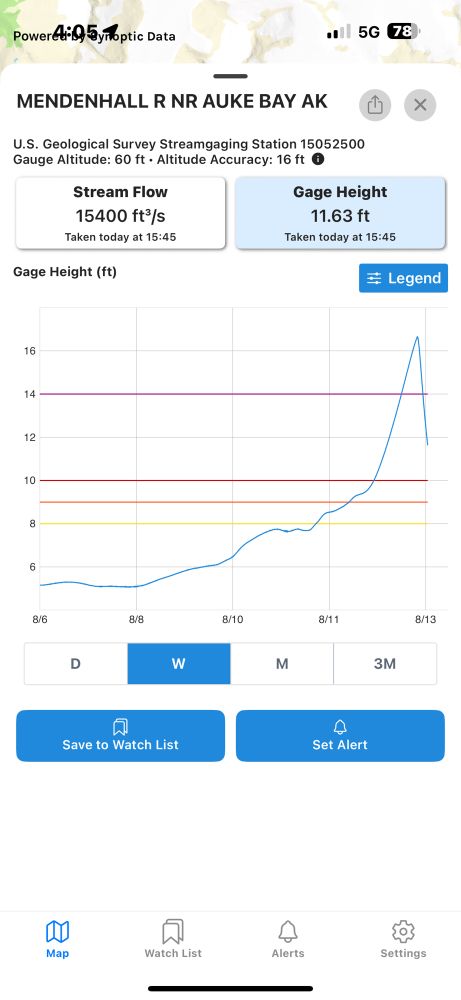
August 13, 2025 at 8:13 PM
Our free app track data from all 13,000 USGS streamgages. This chart shown is the Mendenhall in Alaska reflecting the flood waters. The first view is for today. The second view is for the week. #AK
Real-time monitoring of the Mendenhall USGS streamgage with the RiverAware app (free)

August 13, 2025 at 1:44 AM
Real-time monitoring of the Mendenhall USGS streamgage with the RiverAware app (free)
Download RiverAware app for free real-time flood alerts based on USGS streamgage stations. He’s a screen capture showing rising water in the Yahara River. #madison #flashflood #flood #flooding #WIwx Stay safe out there.

August 10, 2025 at 6:02 PM
Download RiverAware app for free real-time flood alerts based on USGS streamgage stations. He’s a screen capture showing rising water in the Yahara River. #madison #flashflood #flood #flooding #WIwx Stay safe out there.
Stay safe and stay tuned in. This #Milwaukee USGS streamgage shows the water rising in real time as it floods. Many close-by streamgages are viewable in our free app. #flood #flooding #WIwx

August 10, 2025 at 5:35 PM
Stay safe and stay tuned in. This #Milwaukee USGS streamgage shows the water rising in real time as it floods. Many close-by streamgages are viewable in our free app. #flood #flooding #WIwx
RiverAware shares USGS streamgage data, here are three screen shots from some nearby streamgages showing the water rise.


August 10, 2025 at 11:55 AM
RiverAware shares USGS streamgage data, here are three screen shots from some nearby streamgages showing the water rise.
The USGS has several rivergages (yes that is the word USGS uses) that reported in real-time, the historic rise of the flood waters. Here is a historical screenshot from our free app. Stay informed, stay safe, use the resources at hand. Riveraware.app

August 4, 2025 at 6:26 PM
The USGS has several rivergages (yes that is the word USGS uses) that reported in real-time, the historic rise of the flood waters. Here is a historical screenshot from our free app. Stay informed, stay safe, use the resources at hand. Riveraware.app
RiverAware is an easy to use app that uses USGS streamgages to provide you with real-time flood alert information. Free to use. apps.apple.com/us/app/river...
Stay safe out there!
Stay safe out there!

July 31, 2025 at 6:06 PM
RiverAware is an easy to use app that uses USGS streamgages to provide you with real-time flood alert information. Free to use. apps.apple.com/us/app/river...
Stay safe out there!
Stay safe out there!
The devastating river rise in Texas can be easier to comprehend in the context of this 3 month window. Here it is in the RiverAware app. The app provides REAL TIME flood alerts from our government maintained river gauges, as well as historical data. #TXWX

July 29, 2025 at 2:01 PM
The devastating river rise in Texas can be easier to comprehend in the context of this 3 month window. Here it is in the RiverAware app. The app provides REAL TIME flood alerts from our government maintained river gauges, as well as historical data. #TXWX