


Riley Champine
@rileydchampine.com
Cartographer at the University of Richmond Digital Scholarship Lab • Former Graphics Editor at Nat Geo —
🗺️ Map Nerd • 🚲 Bike Commuter • 🚎 Transit Advocate • 🇺🇸 USMNT / 🦘 Richmond Kickers / Fulham FC ⚽️ fan
🗺️ Map Nerd • 🚲 Bike Commuter • 🚎 Transit Advocate • 🇺🇸 USMNT / 🦘 Richmond Kickers / Fulham FC ⚽️ fan

Directly in front of me is the site of Edward Valentine's sculpting studios — which are annotated on the 1905 Sanborn map. Today it's the GRTC transfer center.

March 28, 2025 at 3:22 PM
Directly in front of me is the site of Edward Valentine's sculpting studios — which are annotated on the 1905 Sanborn map. Today it's the GRTC transfer center.

🚲🌊 When the James River and your evening commute become one (Riverside Dr between Rockfalls Dr and the Z Dam).

February 18, 2025 at 12:03 AM
🚲🌊 When the James River and your evening commute become one (Riverside Dr between Rockfalls Dr and the Z Dam).
The outfall events are a huge bummer but there are positive changes in the works to mitigate them. These maps are from the CSO 2024 Final Plan – worth skimming on a torrential day like today. rvah2o.org/wp-content/u...


February 16, 2025 at 7:09 PM
The outfall events are a huge bummer but there are positive changes in the works to mitigate them. These maps are from the CSO 2024 Final Plan – worth skimming on a torrential day like today. rvah2o.org/wp-content/u...
Today's combined Sewage Overflow map AKA "Richmond's Map of Shame" — 12 of 25 outflows currently spewing our raw wastewater into the James and Gillies Creek. apps.emnet.net/richmond-pub...

February 16, 2025 at 6:56 PM
Today's combined Sewage Overflow map AKA "Richmond's Map of Shame" — 12 of 25 outflows currently spewing our raw wastewater into the James and Gillies Creek. apps.emnet.net/richmond-pub...
We're one step away from a beautiful Mayo Bridge... #RVA richmondbizsense.com/2025/02/11/l...

February 11, 2025 at 2:41 PM
We're one step away from a beautiful Mayo Bridge... #RVA richmondbizsense.com/2025/02/11/l...
Latoya Gray-Sparks gave an excellent (and heartbreaking) talk about Urban Renewal history in #RVA tonight. RPL Memory Lab was a great host and put together these fantastic Sanborn map displays with monopoly pieces to show homes razed for Gilpin Court, I-95, and the downtown expressway.


February 11, 2025 at 2:30 AM
Latoya Gray-Sparks gave an excellent (and heartbreaking) talk about Urban Renewal history in #RVA tonight. RPL Memory Lab was a great host and put together these fantastic Sanborn map displays with monopoly pieces to show homes razed for Gilpin Court, I-95, and the downtown expressway.
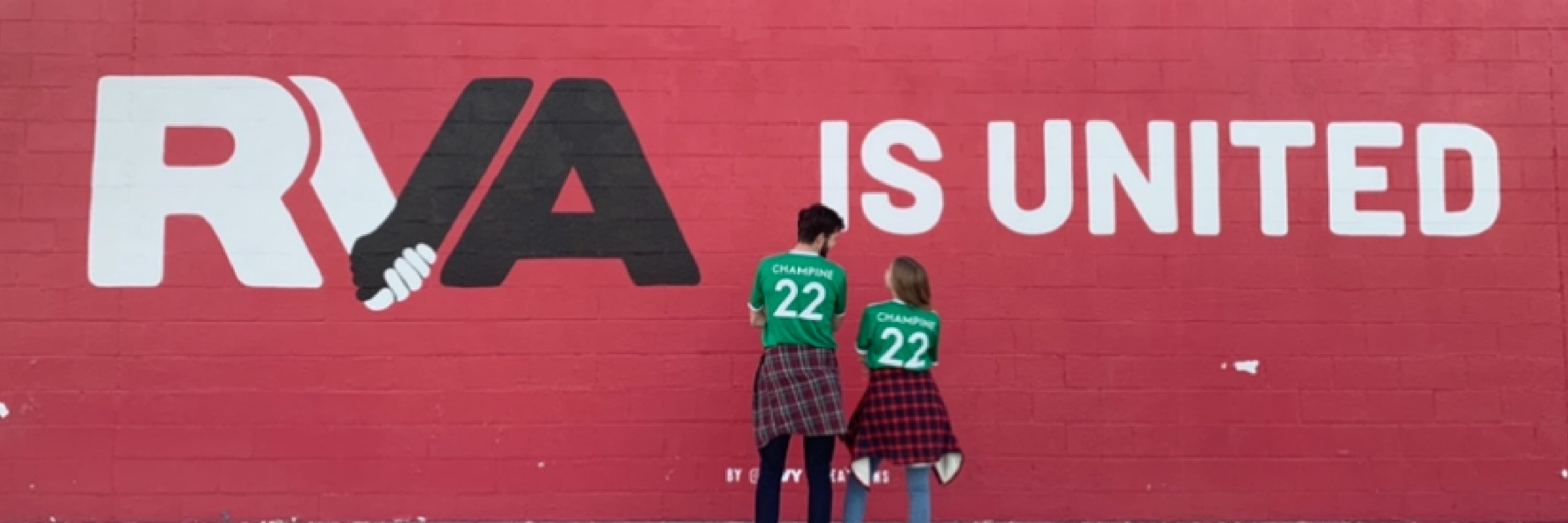
Ever since the @richmondkickers.bsky.social brought out the old '90s logo in 2022 I've been toying with ideas for a new crest that brings back that OG soccer feel in a fresh way. I'm not sure I cracked the code but I wish the new crest went in this direction instead of old-timey baseball.


January 29, 2025 at 6:38 PM
Ever since the @richmondkickers.bsky.social brought out the old '90s logo in 2022 I've been toying with ideas for a new crest that brings back that OG soccer feel in a fresh way. I'm not sure I cracked the code but I wish the new crest went in this direction instead of old-timey baseball.
Wild ice falls in #RVA — at the back of the quarry loop off of the Buttermilk trail. These cliffs seem to have the perfect mix of runoff (possibly spring water?!) and no sun.


January 26, 2025 at 12:15 AM
Wild ice falls in #RVA — at the back of the quarry loop off of the Buttermilk trail. These cliffs seem to have the perfect mix of runoff (possibly spring water?!) and no sun.
Sanborn detail of #Detroit, 1949 — Carstens Elementary School — one of 195 schools closed in Detroit between 2000 and 2015. This section of the city's east side suffered from heavy abandonment, typically attributed to white flight and auto industry consolidation. historicdetroit.org/buildings/ca...
January 3, 2025 at 3:37 PM
Sanborn detail of #Detroit, 1949 — Carstens Elementary School — one of 195 schools closed in Detroit between 2000 and 2015. This section of the city's east side suffered from heavy abandonment, typically attributed to white flight and auto industry consolidation. historicdetroit.org/buildings/ca...

Explore 1952 #Baltimore on Old Insurance Maps: oldinsurancemaps.net/viewer/balti...

December 20, 2024 at 6:04 PM
Explore 1952 #Baltimore on Old Insurance Maps: oldinsurancemaps.net/viewer/balti...
Sanborn detail of #Baltimore 1952: "Public School No 176" aka "Francis M Wood [School] For Handicapped Colored Children". This block and ~20 others would be cleared to build West Baltimore's "Highway to Nowhere". Read more: www.baltimoremagazine.com/section/busi...
December 20, 2024 at 6:04 PM
Sanborn detail of #Baltimore 1952: "Public School No 176" aka "Francis M Wood [School] For Handicapped Colored Children". This block and ~20 others would be cleared to build West Baltimore's "Highway to Nowhere". Read more: www.baltimoremagazine.com/section/busi...
If this is how Disney feels then they should sell ABC and any another entity reporting on the administration. I guess journalism isn’t “family-friendly” 🐀 www.nytimes.com/2024/12/18/b...

December 18, 2024 at 11:58 AM
If this is how Disney feels then they should sell ABC and any another entity reporting on the administration. I guess journalism isn’t “family-friendly” 🐀 www.nytimes.com/2024/12/18/b...
I’m a big fan of these candy cane flex posts now bringing some cheer to Blanton Ave 🎄🚲
December 10, 2024 at 2:40 PM
I’m a big fan of these candy cane flex posts now bringing some cheer to Blanton Ave 🎄🚲
Great find! I found Cave St also on this map made from an 1858 survey. Looks like it went down a long embankment to access Shockoe Creek... so perhaps some evidence for there being an actual cave??? Map lives in Library of Congress here: www.loc.gov/resource/g38...

December 4, 2024 at 8:05 PM
Great find! I found Cave St also on this map made from an 1858 survey. Looks like it went down a long embankment to access Shockoe Creek... so perhaps some evidence for there being an actual cave??? Map lives in Library of Congress here: www.loc.gov/resource/g38...
Sanborn detail of Richmond, VA 1950 — Jackson Ward.
I am so intrigued by this so-called "Cave" street that cut diagonally across the center block here. Was there an actual cave at some point? This block, like so many around it, was razed to make way for the Richmond-Petersburg Turnpike. #RVA
I am so intrigued by this so-called "Cave" street that cut diagonally across the center block here. Was there an actual cave at some point? This block, like so many around it, was razed to make way for the Richmond-Petersburg Turnpike. #RVA
December 4, 2024 at 5:13 PM
Sanborn detail of Richmond, VA 1950 — Jackson Ward.
I am so intrigued by this so-called "Cave" street that cut diagonally across the center block here. Was there an actual cave at some point? This block, like so many around it, was razed to make way for the Richmond-Petersburg Turnpike. #RVA
I am so intrigued by this so-called "Cave" street that cut diagonally across the center block here. Was there an actual cave at some point? This block, like so many around it, was razed to make way for the Richmond-Petersburg Turnpike. #RVA
Screenshot from an alternate reality — the Google Maps search result for "Shockoe County". After reading today's editorial by @times-dispatch.bsky.social, I imagined this fictional county formed by the dissolved boundaries of Chesterfield, Henrico, and Richmond. Article: richmond.com/opinion/edit...

December 2, 2024 at 5:49 PM
Screenshot from an alternate reality — the Google Maps search result for "Shockoe County". After reading today's editorial by @times-dispatch.bsky.social, I imagined this fictional county formed by the dissolved boundaries of Chesterfield, Henrico, and Richmond. Article: richmond.com/opinion/edit...
Sanborn detail of Philadelphia, PA 1950: Dock Street.
It's nutty to me how much building density has changed here in 75 years. Check out this lovely history by NPS on the entombed creek beneath Dock Street and how it was pivotal to the city's founding. npshistory.com/publications...
It's nutty to me how much building density has changed here in 75 years. Check out this lovely history by NPS on the entombed creek beneath Dock Street and how it was pivotal to the city's founding. npshistory.com/publications...
November 30, 2024 at 9:12 PM
Sanborn detail of Philadelphia, PA 1950: Dock Street.
It's nutty to me how much building density has changed here in 75 years. Check out this lovely history by NPS on the entombed creek beneath Dock Street and how it was pivotal to the city's founding. npshistory.com/publications...
It's nutty to me how much building density has changed here in 75 years. Check out this lovely history by NPS on the entombed creek beneath Dock Street and how it was pivotal to the city's founding. npshistory.com/publications...
Shout-out to this restaurant, Herby-K's, in operation since 1936. It's the tiny red building in the bottom left corner of the animation above. From Streetview you can see an abrupt dead-end at I-20 but there are still a few houses. Someone please report back if the Shrimp Buster is worth the trip.


November 26, 2024 at 8:40 PM
Shout-out to this restaurant, Herby-K's, in operation since 1936. It's the tiny red building in the bottom left corner of the animation above. From Streetview you can see an abrupt dead-end at I-20 but there are still a few houses. Someone please report back if the Shrimp Buster is worth the trip.
Sanborn detail of Shreveport, LA 1963: Two annotations, "ALL BLDG'S IN THIS BLOCK REMOVED", record the destruction of a neighborhood in progress. This area, now beneath the interchange of I-20 and I-49, once contained over a hundred dwellings (marked "D" on the maps). It now has almost zero.
November 26, 2024 at 8:40 PM
Sanborn detail of Shreveport, LA 1963: Two annotations, "ALL BLDG'S IN THIS BLOCK REMOVED", record the destruction of a neighborhood in progress. This area, now beneath the interchange of I-20 and I-49, once contained over a hundred dwellings (marked "D" on the maps). It now has almost zero.
This camera operator's cheat-sheet for the NWSL final is fascinating to study for its layout and design. Really impressive amount of quickly legible info and I like the use of varying grids. Bummed the Spirit couldn't pull off the win!
Seen on reddit here: www.reddit.com/r/NWSL/comme...
Seen on reddit here: www.reddit.com/r/NWSL/comme...

November 24, 2024 at 10:32 PM
This camera operator's cheat-sheet for the NWSL final is fascinating to study for its layout and design. Really impressive amount of quickly legible info and I like the use of varying grids. Bummed the Spirit couldn't pull off the win!
Seen on reddit here: www.reddit.com/r/NWSL/comme...
Seen on reddit here: www.reddit.com/r/NWSL/comme...
Sanborn detail of Tacoma, WA 1950: "Stadium High School". Initially designed in 1891 as a château on Commencement Bay, the partially constructed building was repurposed as a public school in 1906. It later appeared in the 1999 film "10 Things I Hate About You". oldinsurancemaps.net/viewer/tacom...

November 22, 2024 at 10:37 PM
Sanborn detail of Tacoma, WA 1950: "Stadium High School". Initially designed in 1891 as a château on Commencement Bay, the partially constructed building was repurposed as a public school in 1906. It later appeared in the 1999 film "10 Things I Hate About You". oldinsurancemaps.net/viewer/tacom...
Sanborn map detail of the day — Buffalo, NY 1950: "New York State Hospital for the Insane". Note the varying construction materials indicated by color fills on the interconnected buildings. This is now the Richardson Olmstead Complex and home to a boutique hotel. oldinsurancemaps.net/map/sanborn0...

November 21, 2024 at 9:16 PM
Sanborn map detail of the day — Buffalo, NY 1950: "New York State Hospital for the Insane". Note the varying construction materials indicated by color fills on the interconnected buildings. This is now the Richardson Olmstead Complex and home to a boutique hotel. oldinsurancemaps.net/map/sanborn0...