


Richard
@rgw3d.com
Cincinnati
Urbanism
Transportation & Land use policy
C++ enjoyer & hater
Urbanism
Transportation & Land use policy
C++ enjoyer & hater

I am so excited for this! I really enjoy old Cincinnati maps, like this 1965 one I'm getting framed. And my wife is going to love the easy Christmas gift

November 3, 2025 at 4:44 AM
I am so excited for this! I really enjoy old Cincinnati maps, like this 1965 one I'm getting framed. And my wife is going to love the easy Christmas gift
Here's a better version of the graph @mrkerrymd.bsky.social

September 16, 2025 at 4:41 PM
Here's a better version of the graph @mrkerrymd.bsky.social
Most of Cincinnati's potholes are along Metro routes.
My latest-and-greatest idea is to utilize SORTA Metro buses as a means of daily detection of potholes, and a google-streetview sort of system for DOTE.
My latest-and-greatest idea is to utilize SORTA Metro buses as a means of daily detection of potholes, and a google-streetview sort of system for DOTE.

September 14, 2025 at 6:38 PM
Most of Cincinnati's potholes are along Metro routes.
My latest-and-greatest idea is to utilize SORTA Metro buses as a means of daily detection of potholes, and a google-streetview sort of system for DOTE.
My latest-and-greatest idea is to utilize SORTA Metro buses as a means of daily detection of potholes, and a google-streetview sort of system for DOTE.
More speed relates to more pothole reports

September 12, 2025 at 6:28 AM
More speed relates to more pothole reports
The outlier here is S-HAM26450, Madison Rd between Ridge & Kennedy. It was paved in June of last year.

September 12, 2025 at 6:13 AM
The outlier here is S-HAM26450, Madison Rd between Ridge & Kennedy. It was paved in June of last year.
More 3d plots of Speed Vs. PotholeCount Vs. Width at different snowplow priorities


September 12, 2025 at 6:13 AM
More 3d plots of Speed Vs. PotholeCount Vs. Width at different snowplow priorities
Finally got the good SQL query running against the best datasets that I have:
1) CAGIS Hamilton County Polygons
2) Snowplow priority routes -- multistring with road speedlimits!
3) Pothole report data since 2023
4) Cincinnati City Outline
1) CAGIS Hamilton County Polygons
2) Snowplow priority routes -- multistring with road speedlimits!
3) Pothole report data since 2023
4) Cincinnati City Outline

September 12, 2025 at 6:13 AM
Finally got the good SQL query running against the best datasets that I have:
1) CAGIS Hamilton County Polygons
2) Snowplow priority routes -- multistring with road speedlimits!
3) Pothole report data since 2023
4) Cincinnati City Outline
1) CAGIS Hamilton County Polygons
2) Snowplow priority routes -- multistring with road speedlimits!
3) Pothole report data since 2023
4) Cincinnati City Outline
What I want to pitch is that higher road speeds are a direct contributor of potholes. The solution is that while you are repaving a road, installing road features that limit speed will extend the life of the pavement.
See these basic graphs of road speed vs pothole reports per acre.
See these basic graphs of road speed vs pothole reports per acre.


September 12, 2025 at 4:37 AM
What I want to pitch is that higher road speeds are a direct contributor of potholes. The solution is that while you are repaving a road, installing road features that limit speed will extend the life of the pavement.
See these basic graphs of road speed vs pothole reports per acre.
See these basic graphs of road speed vs pothole reports per acre.
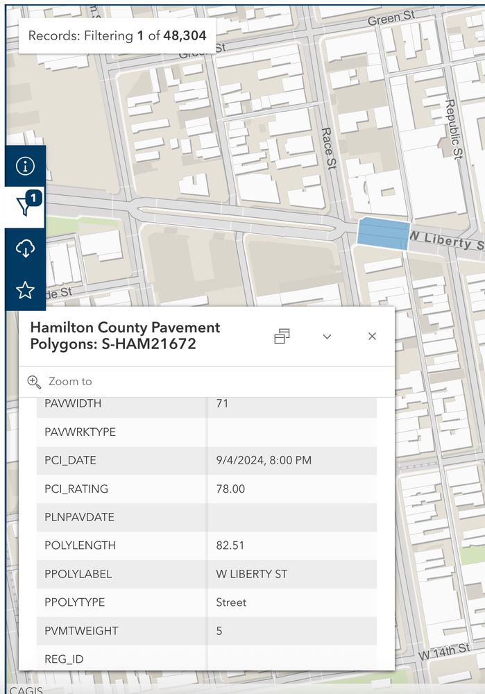
For example, this specific pavement polygon at the intersection of Race & Liberty: S-HAM21672
* Paved around 2021-04-12 and had a PCI of 100
* Later in 2021 had a PCI of 95
* 2023-05-21 had a PCI of 88
* Currently (9/4/24) has a PCI of 78
* Paved around 2021-04-12 and had a PCI of 100
* Later in 2021 had a PCI of 95
* 2023-05-21 had a PCI of 88
* Currently (9/4/24) has a PCI of 78
September 8, 2025 at 4:27 AM
For example, this specific pavement polygon at the intersection of Race & Liberty: S-HAM21672
* Paved around 2021-04-12 and had a PCI of 100
* Later in 2021 had a PCI of 95
* 2023-05-21 had a PCI of 88
* Currently (9/4/24) has a PCI of 78
* Paved around 2021-04-12 and had a PCI of 100
* Later in 2021 had a PCI of 95
* 2023-05-21 had a PCI of 88
* Currently (9/4/24) has a PCI of 78
Three years of data points probably isn't enough for a great model, but we have to start somewhere. Ideally I can use this curve as a reference

September 6, 2025 at 2:49 PM
Three years of data points probably isn't enough for a great model, but we have to start somewhere. Ideally I can use this curve as a reference
CAGIS Hamilton County Pavement Polygons is the best resource. I'm unsure if I can access historical revisions of this data. That'd be great if possible. Ideally there is data older than 2021
Fortunately the polygon names `S-HAM19416` are consistent throughout the documents.
Fortunately the polygon names `S-HAM19416` are consistent throughout the documents.

September 6, 2025 at 2:49 PM
CAGIS Hamilton County Pavement Polygons is the best resource. I'm unsure if I can access historical revisions of this data. That'd be great if possible. Ideally there is data older than 2021
Fortunately the polygon names `S-HAM19416` are consistent throughout the documents.
Fortunately the polygon names `S-HAM19416` are consistent throughout the documents.
Old Streetcar rail & cobblestones poking through on Walnut & 12th.

February 18, 2025 at 4:55 PM
Old Streetcar rail & cobblestones poking through on Walnut & 12th.
Clare yard's bridge over the Little Miami


January 24, 2025 at 9:45 PM
Clare yard's bridge over the Little Miami


It works! Here it is up against the Transit app (which hits the same API)
There is a little wonkyness around the Streetcar depot, but I can probably fix that
There is a little wonkyness around the Streetcar depot, but I can probably fix that
January 13, 2025 at 5:38 PM
It works! Here it is up against the Transit app (which hits the same API)
There is a little wonkyness around the Streetcar depot, but I can probably fix that
There is a little wonkyness around the Streetcar depot, but I can probably fix that
Basic I2C comms are working! The only hiccup was configuring the correct pins.
Debugging I2C or SPI is one of my least favorite things to do. Awesome work as usual by Adafruit for providing an excellent library that just worked. (And the team behind the ESP32 Arduino codebase)
Debugging I2C or SPI is one of my least favorite things to do. Awesome work as usual by Adafruit for providing an excellent library that just worked. (And the team behind the ESP32 Arduino codebase)
January 11, 2025 at 4:42 PM
Basic I2C comms are working! The only hiccup was configuring the correct pins.
Debugging I2C or SPI is one of my least favorite things to do. Awesome work as usual by Adafruit for providing an excellent library that just worked. (And the team behind the ESP32 Arduino codebase)
Debugging I2C or SPI is one of my least favorite things to do. Awesome work as usual by Adafruit for providing an excellent library that just worked. (And the team behind the ESP32 Arduino codebase)
All soldered! And I'm able to connect and program the ESP32.
Now I have to do my least favorite but most important part - write the rest of the damn software. At least the Arduino ecosystem is good
Now I have to do my least favorite but most important part - write the rest of the damn software. At least the Arduino ecosystem is good


January 9, 2025 at 4:25 AM
All soldered! And I'm able to connect and program the ESP32.
Now I have to do my least favorite but most important part - write the rest of the damn software. At least the Arduino ecosystem is good
Now I have to do my least favorite but most important part - write the rest of the damn software. At least the Arduino ecosystem is good
The PCB for the real-time Cincinnati Streetcar arrived!
Hopefully it works!
Hopefully it works!

January 9, 2025 at 2:20 AM
The PCB for the real-time Cincinnati Streetcar arrived!
Hopefully it works!
Hopefully it works!
Looks like the SouthBank shuttle really took a hit. The other routes I mentioned don't seem that different

January 8, 2025 at 3:20 PM
Looks like the SouthBank shuttle really took a hit. The other routes I mentioned don't seem that different

SORTA completed my request sorta-oh.nextrequest.com/requests/24-... , but unfortunately I don't think the request results are public(?)
Anyway, the data is in the form of a glossy report showing various metrics. @mrkerrymd.bsky.social will probably tell me that this was already publicly available.
Anyway, the data is in the form of a glossy report showing various metrics. @mrkerrymd.bsky.social will probably tell me that this was already publicly available.


January 4, 2025 at 7:26 PM
SORTA completed my request sorta-oh.nextrequest.com/requests/24-... , but unfortunately I don't think the request results are public(?)
Anyway, the data is in the form of a glossy report showing various metrics. @mrkerrymd.bsky.social will probably tell me that this was already publicly available.
Anyway, the data is in the form of a glossy report showing various metrics. @mrkerrymd.bsky.social will probably tell me that this was already publicly available.
