


Nathan Ruser
@nrg8000.bsky.social
@Nrg8000 on twitter. Will fill this out when twitter inevitably burns.
And here are all the sites on an interactive Google Earth project. earth.google.com/earth/d/1FDs...
I will add to this link if any new data becomes available too.
I will add to this link if any new data becomes available too.
Google Earth
earth.google.com
May 7, 2025 at 1:47 PM
And here are all the sites on an interactive Google Earth project. earth.google.com/earth/d/1FDs...
I will add to this link if any new data becomes available too.
I will add to this link if any new data becomes available too.
Overall, here are all the sites on a map.


May 7, 2025 at 1:46 PM
Overall, here are all the sites on a map.
9. 'Sawai Nala' Camp.
Approx. 34.391064°N 73.449336°E
google.com/maps/place/3...
This is the one site that has not been presented as either a slide or a handout by the IAF, so its exact location is impossible to pinpoint; it appears to be around here.
Can't say much else.
Approx. 34.391064°N 73.449336°E
google.com/maps/place/3...
This is the one site that has not been presented as either a slide or a handout by the IAF, so its exact location is impossible to pinpoint; it appears to be around here.
Can't say much else.

May 7, 2025 at 1:46 PM
9. 'Sawai Nala' Camp.
Approx. 34.391064°N 73.449336°E
google.com/maps/place/3...
This is the one site that has not been presented as either a slide or a handout by the IAF, so its exact location is impossible to pinpoint; it appears to be around here.
Can't say much else.
Approx. 34.391064°N 73.449336°E
google.com/maps/place/3...
This is the one site that has not been presented as either a slide or a handout by the IAF, so its exact location is impossible to pinpoint; it appears to be around here.
Can't say much else.
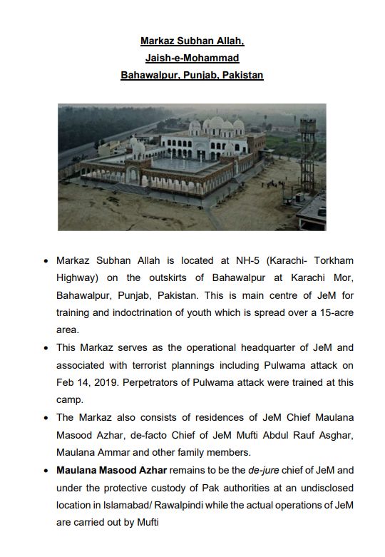
8. Masjid Subhan Allah, Bahawalpur
31.838263°N 74.259836°E
google.com/maps/place/2...
Post-strike photos that appear real on their face seem to show the site nearly completely destroyed, including one of the domes.
31.838263°N 74.259836°E
google.com/maps/place/2...
Post-strike photos that appear real on their face seem to show the site nearly completely destroyed, including one of the domes.


May 7, 2025 at 1:46 PM
8. Masjid Subhan Allah, Bahawalpur
31.838263°N 74.259836°E
google.com/maps/place/2...
Post-strike photos that appear real on their face seem to show the site nearly completely destroyed, including one of the domes.
31.838263°N 74.259836°E
google.com/maps/place/2...
Post-strike photos that appear real on their face seem to show the site nearly completely destroyed, including one of the domes.
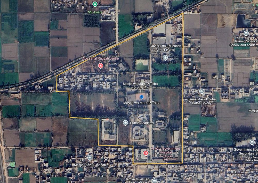
7. Masjid wa Markaz Taiba
31.838263°N 74.259836°E
google.com/maps/place/3...
The perimeter as mapped includes a hospital and several schools and colleges.
The strike imagery is distant but appears to show a pretty much a hit on the Masjid, perhaps slightly to the north-west.
31.838263°N 74.259836°E
google.com/maps/place/3...
The perimeter as mapped includes a hospital and several schools and colleges.
The strike imagery is distant but appears to show a pretty much a hit on the Masjid, perhaps slightly to the north-west.

May 7, 2025 at 1:45 PM
7. Masjid wa Markaz Taiba
31.838263°N 74.259836°E
google.com/maps/place/3...
The perimeter as mapped includes a hospital and several schools and colleges.
The strike imagery is distant but appears to show a pretty much a hit on the Masjid, perhaps slightly to the north-west.
31.838263°N 74.259836°E
google.com/maps/place/3...
The perimeter as mapped includes a hospital and several schools and colleges.
The strike imagery is distant but appears to show a pretty much a hit on the Masjid, perhaps slightly to the north-west.
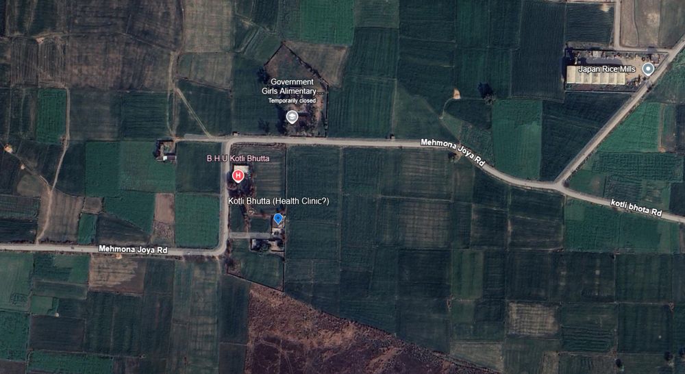
6. Kotli Butta site (health clinic?) 32.617123°N 74.505696°E google.com/maps/place/3...
Google calls this a Basic Health Unit site, but with no pictures or reviews. It is not listed on HDX's health-sites database or OSM. So I'm really not sure, some sources called it a 'seminary'.
Google calls this a Basic Health Unit site, but with no pictures or reviews. It is not listed on HDX's health-sites database or OSM. So I'm really not sure, some sources called it a 'seminary'.

May 7, 2025 at 1:45 PM
6. Kotli Butta site (health clinic?) 32.617123°N 74.505696°E google.com/maps/place/3...
Google calls this a Basic Health Unit site, but with no pictures or reviews. It is not listed on HDX's health-sites database or OSM. So I'm really not sure, some sources called it a 'seminary'.
Google calls this a Basic Health Unit site, but with no pictures or reviews. It is not listed on HDX's health-sites database or OSM. So I'm really not sure, some sources called it a 'seminary'.
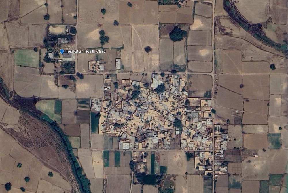
5. Terakatlan Health Clinic, Sialkot.
32.360346°N 75.124897°E
google.com/maps/place/3...
This location appears to be a primary health clinic. Some nationalist bloggers are claiming it was used to 'house terrorists before crossing the border'.
Idk about that, it was a health clinic.
32.360346°N 75.124897°E
google.com/maps/place/3...
This location appears to be a primary health clinic. Some nationalist bloggers are claiming it was used to 'house terrorists before crossing the border'.
Idk about that, it was a health clinic.


May 7, 2025 at 1:44 PM
5. Terakatlan Health Clinic, Sialkot.
32.360346°N 75.124897°E
google.com/maps/place/3...
This location appears to be a primary health clinic. Some nationalist bloggers are claiming it was used to 'house terrorists before crossing the border'.
Idk about that, it was a health clinic.
32.360346°N 75.124897°E
google.com/maps/place/3...
This location appears to be a primary health clinic. Some nationalist bloggers are claiming it was used to 'house terrorists before crossing the border'.
Idk about that, it was a health clinic.
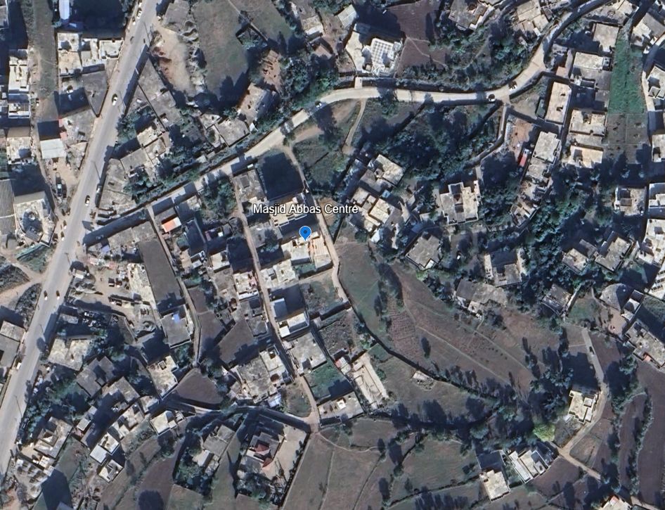
4. Masjid Abbas in Kotli
33.508495°N 73.906416°E
google.com/maps/place/3...
The strike-vision provided is too distant to determine the exact impact, but no reason to think it hit anything but the target.
33.508495°N 73.906416°E
google.com/maps/place/3...
The strike-vision provided is too distant to determine the exact impact, but no reason to think it hit anything but the target.

May 7, 2025 at 1:44 PM
4. Masjid Abbas in Kotli
33.508495°N 73.906416°E
google.com/maps/place/3...
The strike-vision provided is too distant to determine the exact impact, but no reason to think it hit anything but the target.
33.508495°N 73.906416°E
google.com/maps/place/3...
The strike-vision provided is too distant to determine the exact impact, but no reason to think it hit anything but the target.
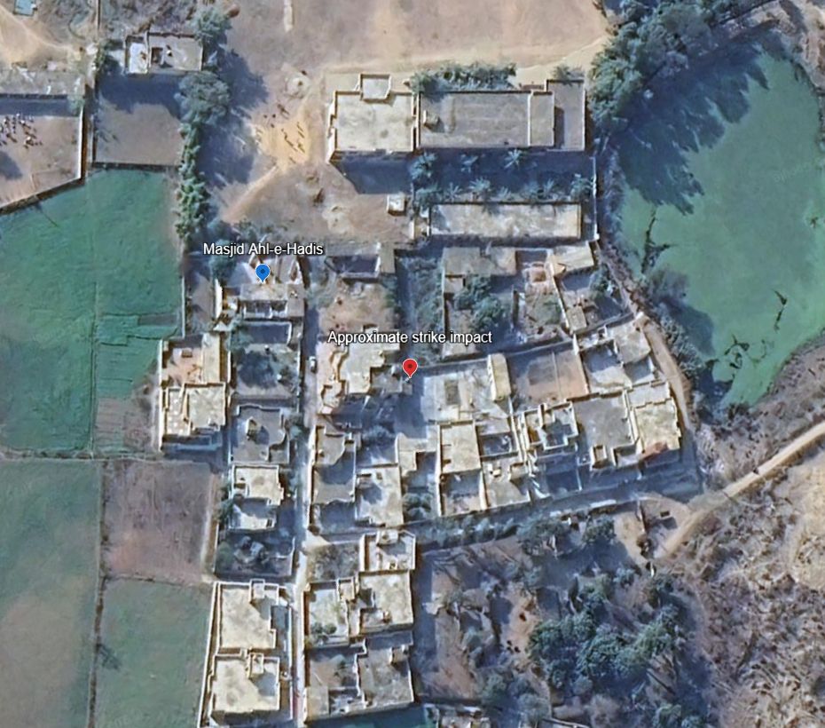
3. Masjid Ahl-e-Hadis in Barnala, Bhimber.
32.867802°N 74.256469°E
google.com/maps/place/3...
Quadcopter-dropped munition appear to miss the target building and strike a courtyard around 50m away.
32.867802°N 74.256469°E
google.com/maps/place/3...
Quadcopter-dropped munition appear to miss the target building and strike a courtyard around 50m away.

May 7, 2025 at 1:43 PM
3. Masjid Ahl-e-Hadis in Barnala, Bhimber.
32.867802°N 74.256469°E
google.com/maps/place/3...
Quadcopter-dropped munition appear to miss the target building and strike a courtyard around 50m away.
32.867802°N 74.256469°E
google.com/maps/place/3...
Quadcopter-dropped munition appear to miss the target building and strike a courtyard around 50m away.
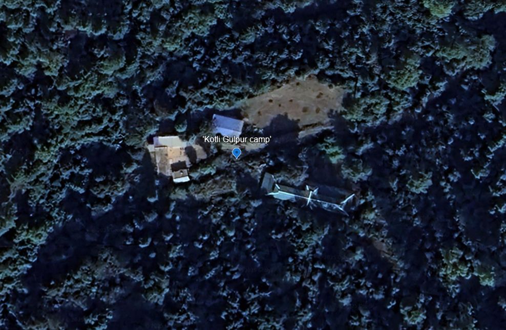
2. Reported training camp in Gulpur, Kotli
33.402328°N 73.876957°E
No post-strike imagery yet.
google.com/maps/place/3...
33.402328°N 73.876957°E
No post-strike imagery yet.
google.com/maps/place/3...
May 7, 2025 at 1:43 PM
2. Reported training camp in Gulpur, Kotli
33.402328°N 73.876957°E
No post-strike imagery yet.
google.com/maps/place/3...
33.402328°N 73.876957°E
No post-strike imagery yet.
google.com/maps/place/3...
Further south, the main road from the airport to Naypyidaw has deformed and been damaged. www.google.com/maps/place/1...

April 3, 2025 at 12:31 AM
Further south, the main road from the airport to Naypyidaw has deformed and been damaged. www.google.com/maps/place/1...
In the barracks of Naypyidaw airbase, you can see a building that has split down the middle with the rupture. www.google.com/maps/place/1...


April 3, 2025 at 12:29 AM
In the barracks of Naypyidaw airbase, you can see a building that has split down the middle with the rupture. www.google.com/maps/place/1...
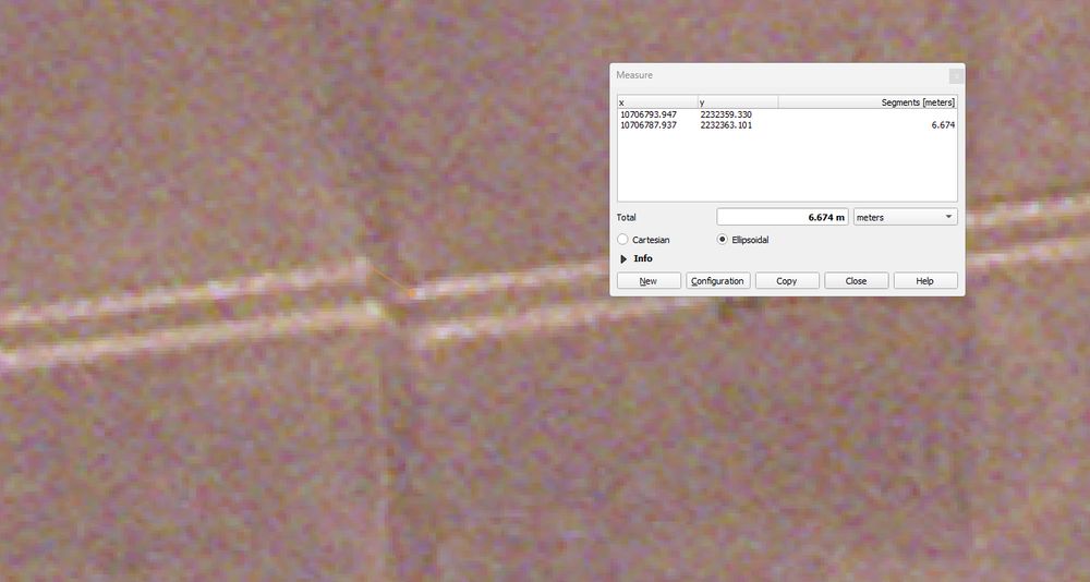
Near Naypyidaw airport, you can see a dirt track (or irrigation infrastructure) that has been split by the rupture, with a displacement of around >6m. Nearby, a sealed road has split too.
www.google.com/maps/place/1...
www.google.com/maps/place/1...


April 3, 2025 at 12:25 AM
Near Naypyidaw airport, you can see a dirt track (or irrigation infrastructure) that has been split by the rupture, with a displacement of around >6m. Nearby, a sealed road has split too.
www.google.com/maps/place/1...
www.google.com/maps/place/1...
The new satellite imagery to the right of the surface rupture is perfectly aligned with the historical Google imagery. On the left, you can see the rupture and offset.
April 2, 2025 at 1:28 PM
The new satellite imagery to the right of the surface rupture is perfectly aligned with the historical Google imagery. On the left, you can see the rupture and offset.
various open data programs by satellite companies, that map is mostly Planet imagery, but I've also been looking at Maxar and Airbus released imagery
March 31, 2025 at 5:09 AM
various open data programs by satellite companies, that map is mostly Planet imagery, but I've also been looking at Maxar and Airbus released imagery
Yep, just by hand and visual interpretation. Unfortunately I've just had time to manually identify the damage points and not add metadata yet. EERI is welcome to any of it though!
March 31, 2025 at 4:52 AM
Yep, just by hand and visual interpretation. Unfortunately I've just had time to manually identify the damage points and not add metadata yet. EERI is welcome to any of it though!
If you're using this in published media reports, please credit Nathan Ruser / ASPI - credit is not necessary for other uses.
March 31, 2025 at 4:06 AM
If you're using this in published media reports, please credit Nathan Ruser / ASPI - credit is not necessary for other uses.
The IDP mapping is a late addition so it is not as comprehensive yet as everything else, but working on it.
No imagery is available yet for most of East Mandalay City or Naypyidaw. I will add it whenever possible.
No imagery is available yet for most of East Mandalay City or Naypyidaw. I will add it whenever possible.
March 31, 2025 at 4:05 AM
The IDP mapping is a late addition so it is not as comprehensive yet as everything else, but working on it.
No imagery is available yet for most of East Mandalay City or Naypyidaw. I will add it whenever possible.
No imagery is available yet for most of East Mandalay City or Naypyidaw. I will add it whenever possible.
In total it shows around 140 structures damaged/destroyed (excluding ~330 destroyed by fire - not mapped per structure).
It has around 60 high-priority rescue sites where large apartment complexes have collapsed, or gathering places (mosques, schools, monasteries etc.) have been destroyed.
It has around 60 high-priority rescue sites where large apartment complexes have collapsed, or gathering places (mosques, schools, monasteries etc.) have been destroyed.
March 31, 2025 at 3:51 AM
In total it shows around 140 structures damaged/destroyed (excluding ~330 destroyed by fire - not mapped per structure).
It has around 60 high-priority rescue sites where large apartment complexes have collapsed, or gathering places (mosques, schools, monasteries etc.) have been destroyed.
It has around 60 high-priority rescue sites where large apartment complexes have collapsed, or gathering places (mosques, schools, monasteries etc.) have been destroyed.
ANY organisation or individual is welcome to download and use this data for any purpose, especially if it can assist in rescue and recovery efforts.
March 31, 2025 at 3:51 AM
ANY organisation or individual is welcome to download and use this data for any purpose, especially if it can assist in rescue and recovery efforts.