


Nathan Ruser
@nrg8000.bsky.social
@Nrg8000 on twitter. Will fill this out when twitter inevitably burns.
Overall, here are all the sites on a map.


May 7, 2025 at 1:46 PM
Overall, here are all the sites on a map.
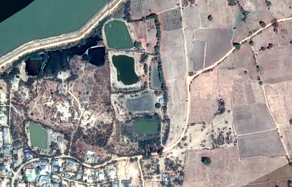
9. 'Sawai Nala' Camp.
Approx. 34.391064°N 73.449336°E
google.com/maps/place/3...
This is the one site that has not been presented as either a slide or a handout by the IAF, so its exact location is impossible to pinpoint; it appears to be around here.
Can't say much else.
Approx. 34.391064°N 73.449336°E
google.com/maps/place/3...
This is the one site that has not been presented as either a slide or a handout by the IAF, so its exact location is impossible to pinpoint; it appears to be around here.
Can't say much else.

May 7, 2025 at 1:46 PM
9. 'Sawai Nala' Camp.
Approx. 34.391064°N 73.449336°E
google.com/maps/place/3...
This is the one site that has not been presented as either a slide or a handout by the IAF, so its exact location is impossible to pinpoint; it appears to be around here.
Can't say much else.
Approx. 34.391064°N 73.449336°E
google.com/maps/place/3...
This is the one site that has not been presented as either a slide or a handout by the IAF, so its exact location is impossible to pinpoint; it appears to be around here.
Can't say much else.
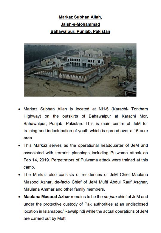
8. Masjid Subhan Allah, Bahawalpur
31.838263°N 74.259836°E
google.com/maps/place/2...
Post-strike photos that appear real on their face seem to show the site nearly completely destroyed, including one of the domes.
31.838263°N 74.259836°E
google.com/maps/place/2...
Post-strike photos that appear real on their face seem to show the site nearly completely destroyed, including one of the domes.


May 7, 2025 at 1:46 PM
8. Masjid Subhan Allah, Bahawalpur
31.838263°N 74.259836°E
google.com/maps/place/2...
Post-strike photos that appear real on their face seem to show the site nearly completely destroyed, including one of the domes.
31.838263°N 74.259836°E
google.com/maps/place/2...
Post-strike photos that appear real on their face seem to show the site nearly completely destroyed, including one of the domes.
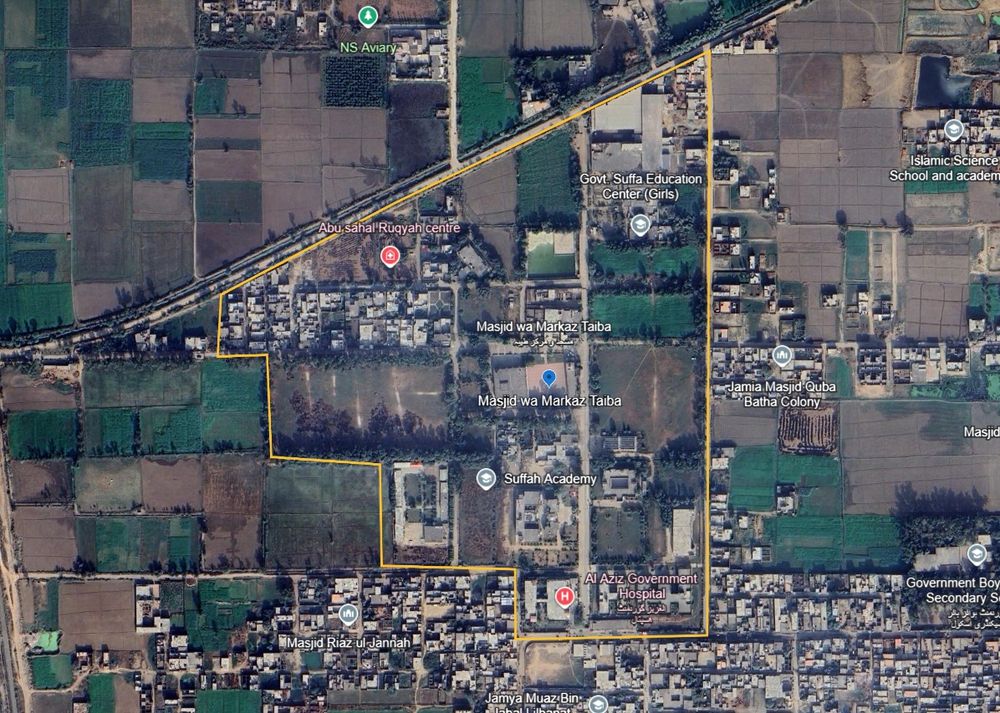
7. Masjid wa Markaz Taiba
31.838263°N 74.259836°E
google.com/maps/place/3...
The perimeter as mapped includes a hospital and several schools and colleges.
The strike imagery is distant but appears to show a pretty much a hit on the Masjid, perhaps slightly to the north-west.
31.838263°N 74.259836°E
google.com/maps/place/3...
The perimeter as mapped includes a hospital and several schools and colleges.
The strike imagery is distant but appears to show a pretty much a hit on the Masjid, perhaps slightly to the north-west.

May 7, 2025 at 1:45 PM
7. Masjid wa Markaz Taiba
31.838263°N 74.259836°E
google.com/maps/place/3...
The perimeter as mapped includes a hospital and several schools and colleges.
The strike imagery is distant but appears to show a pretty much a hit on the Masjid, perhaps slightly to the north-west.
31.838263°N 74.259836°E
google.com/maps/place/3...
The perimeter as mapped includes a hospital and several schools and colleges.
The strike imagery is distant but appears to show a pretty much a hit on the Masjid, perhaps slightly to the north-west.
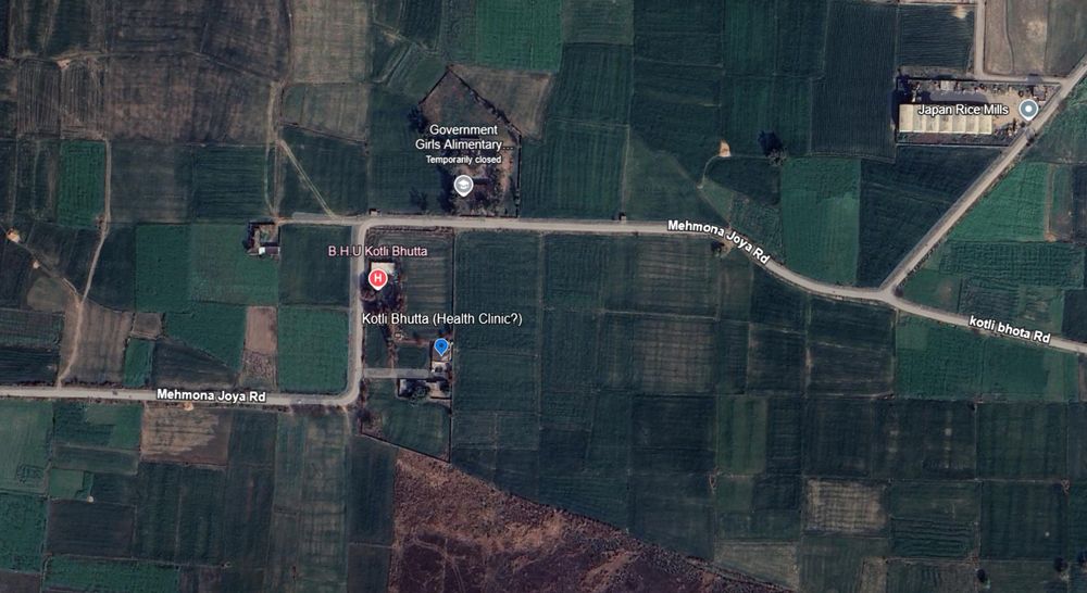
6. Kotli Butta site (health clinic?) 32.617123°N 74.505696°E google.com/maps/place/3...
Google calls this a Basic Health Unit site, but with no pictures or reviews. It is not listed on HDX's health-sites database or OSM. So I'm really not sure, some sources called it a 'seminary'.
Google calls this a Basic Health Unit site, but with no pictures or reviews. It is not listed on HDX's health-sites database or OSM. So I'm really not sure, some sources called it a 'seminary'.

May 7, 2025 at 1:45 PM
6. Kotli Butta site (health clinic?) 32.617123°N 74.505696°E google.com/maps/place/3...
Google calls this a Basic Health Unit site, but with no pictures or reviews. It is not listed on HDX's health-sites database or OSM. So I'm really not sure, some sources called it a 'seminary'.
Google calls this a Basic Health Unit site, but with no pictures or reviews. It is not listed on HDX's health-sites database or OSM. So I'm really not sure, some sources called it a 'seminary'.
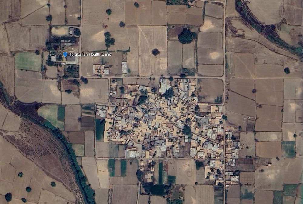
5. Terakatlan Health Clinic, Sialkot.
32.360346°N 75.124897°E
google.com/maps/place/3...
This location appears to be a primary health clinic. Some nationalist bloggers are claiming it was used to 'house terrorists before crossing the border'.
Idk about that, it was a health clinic.
32.360346°N 75.124897°E
google.com/maps/place/3...
This location appears to be a primary health clinic. Some nationalist bloggers are claiming it was used to 'house terrorists before crossing the border'.
Idk about that, it was a health clinic.


May 7, 2025 at 1:44 PM
5. Terakatlan Health Clinic, Sialkot.
32.360346°N 75.124897°E
google.com/maps/place/3...
This location appears to be a primary health clinic. Some nationalist bloggers are claiming it was used to 'house terrorists before crossing the border'.
Idk about that, it was a health clinic.
32.360346°N 75.124897°E
google.com/maps/place/3...
This location appears to be a primary health clinic. Some nationalist bloggers are claiming it was used to 'house terrorists before crossing the border'.
Idk about that, it was a health clinic.
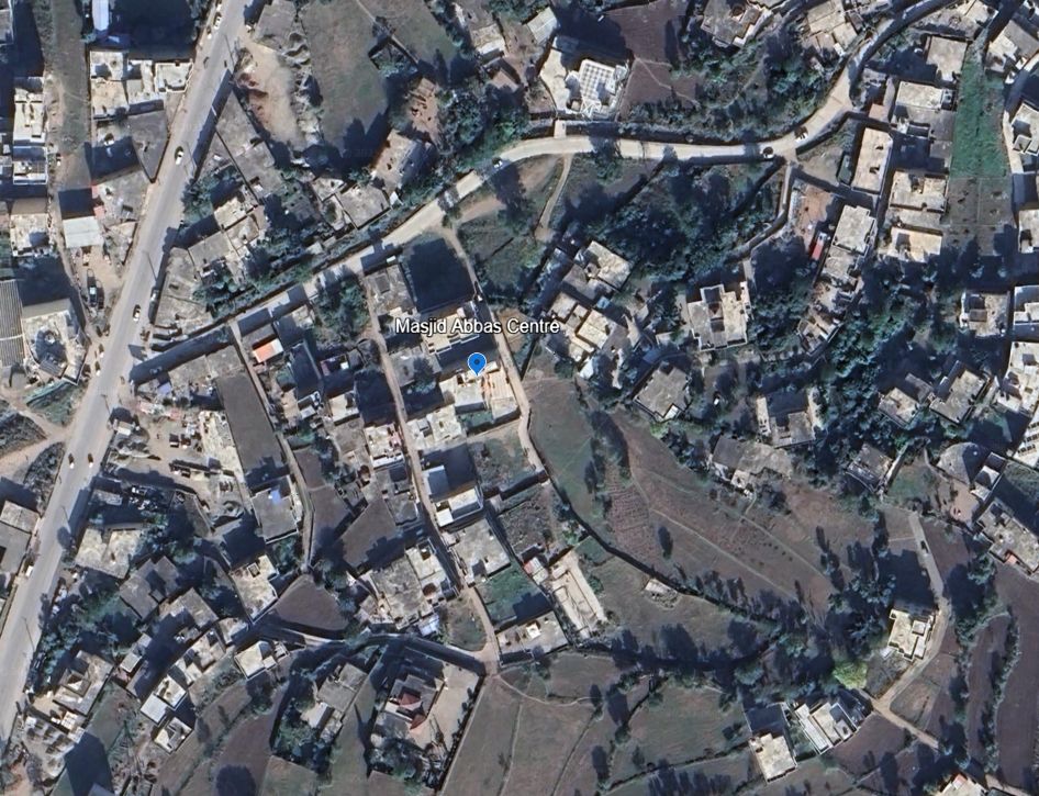
4. Masjid Abbas in Kotli
33.508495°N 73.906416°E
google.com/maps/place/3...
The strike-vision provided is too distant to determine the exact impact, but no reason to think it hit anything but the target.
33.508495°N 73.906416°E
google.com/maps/place/3...
The strike-vision provided is too distant to determine the exact impact, but no reason to think it hit anything but the target.

May 7, 2025 at 1:44 PM
4. Masjid Abbas in Kotli
33.508495°N 73.906416°E
google.com/maps/place/3...
The strike-vision provided is too distant to determine the exact impact, but no reason to think it hit anything but the target.
33.508495°N 73.906416°E
google.com/maps/place/3...
The strike-vision provided is too distant to determine the exact impact, but no reason to think it hit anything but the target.
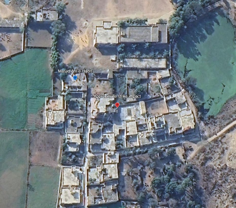
3. Masjid Ahl-e-Hadis in Barnala, Bhimber.
32.867802°N 74.256469°E
google.com/maps/place/3...
Quadcopter-dropped munition appear to miss the target building and strike a courtyard around 50m away.
32.867802°N 74.256469°E
google.com/maps/place/3...
Quadcopter-dropped munition appear to miss the target building and strike a courtyard around 50m away.

May 7, 2025 at 1:43 PM
3. Masjid Ahl-e-Hadis in Barnala, Bhimber.
32.867802°N 74.256469°E
google.com/maps/place/3...
Quadcopter-dropped munition appear to miss the target building and strike a courtyard around 50m away.
32.867802°N 74.256469°E
google.com/maps/place/3...
Quadcopter-dropped munition appear to miss the target building and strike a courtyard around 50m away.
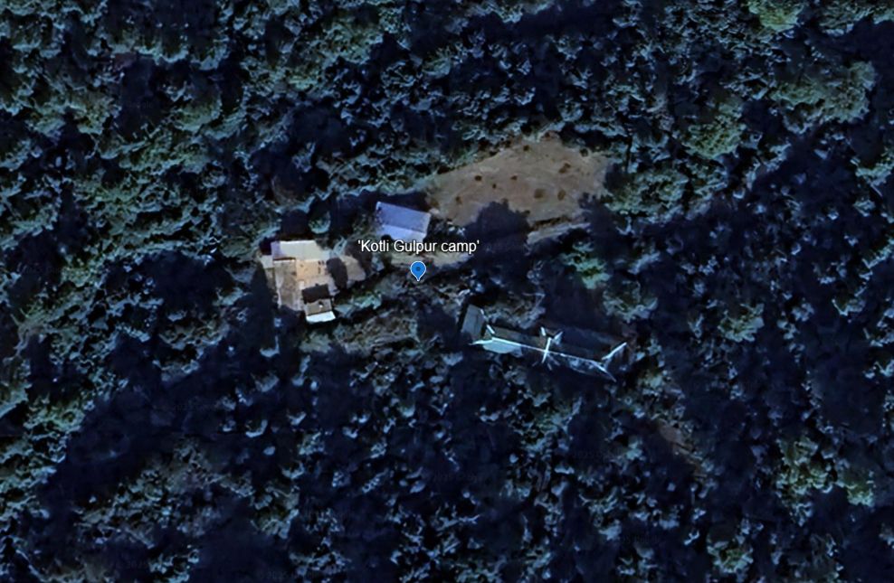
2. Reported training camp in Gulpur, Kotli
33.402328°N 73.876957°E
No post-strike imagery yet.
google.com/maps/place/3...
33.402328°N 73.876957°E
No post-strike imagery yet.
google.com/maps/place/3...
May 7, 2025 at 1:43 PM
2. Reported training camp in Gulpur, Kotli
33.402328°N 73.876957°E
No post-strike imagery yet.
google.com/maps/place/3...
33.402328°N 73.876957°E
No post-strike imagery yet.
google.com/maps/place/3...
🧵Geolocations of ALL sites that the Indian Army has claimed to have hit in Pakistan and Kashmir.
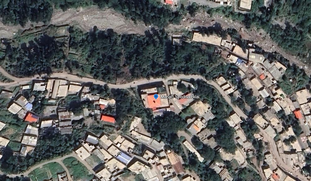
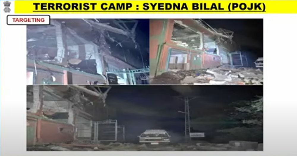
1. Masjid Syedna Bilal/Hazrat Bilal
34.385846°N 73.456974°E
It appears to have been a direct hit, according to after-strike ground photos.
google.com/maps/place/3...
1. Masjid Syedna Bilal/Hazrat Bilal
34.385846°N 73.456974°E
It appears to have been a direct hit, according to after-strike ground photos.
google.com/maps/place/3...
May 7, 2025 at 1:42 PM
🧵Geolocations of ALL sites that the Indian Army has claimed to have hit in Pakistan and Kashmir.
1. Masjid Syedna Bilal/Hazrat Bilal
34.385846°N 73.456974°E
It appears to have been a direct hit, according to after-strike ground photos.
google.com/maps/place/3...
1. Masjid Syedna Bilal/Hazrat Bilal
34.385846°N 73.456974°E
It appears to have been a direct hit, according to after-strike ground photos.
google.com/maps/place/3...
Further south, the main road from the airport to Naypyidaw has deformed and been damaged. www.google.com/maps/place/1...

April 3, 2025 at 12:31 AM
Further south, the main road from the airport to Naypyidaw has deformed and been damaged. www.google.com/maps/place/1...
In the barracks of Naypyidaw airbase, you can see a building that has split down the middle with the rupture. www.google.com/maps/place/1...


April 3, 2025 at 12:29 AM
In the barracks of Naypyidaw airbase, you can see a building that has split down the middle with the rupture. www.google.com/maps/place/1...
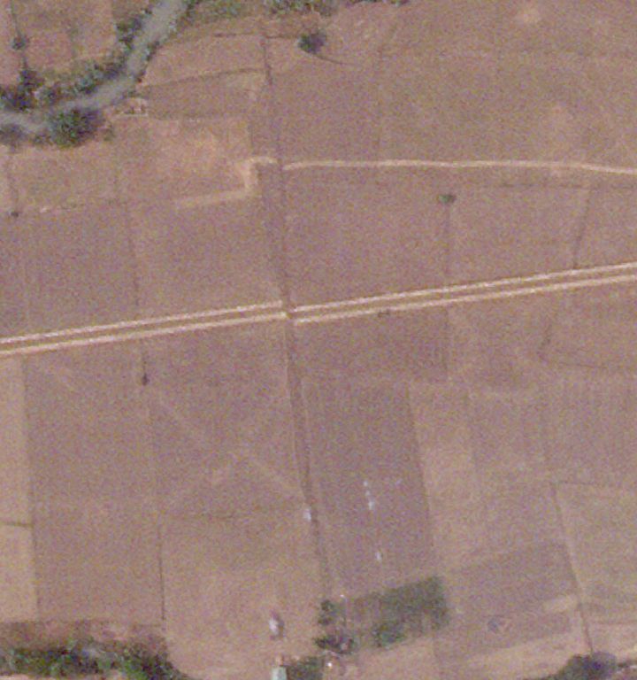
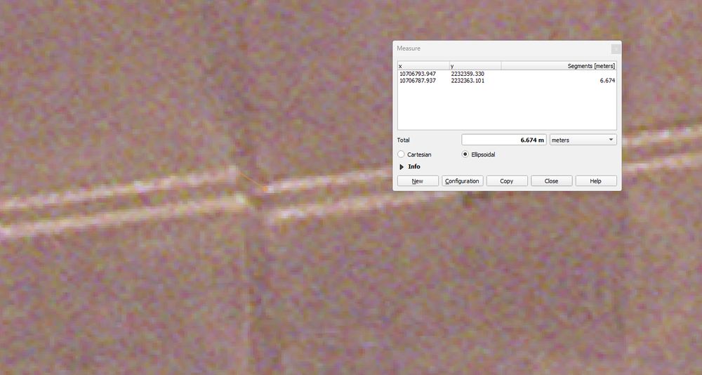
Near Naypyidaw airport, you can see a dirt track (or irrigation infrastructure) that has been split by the rupture, with a displacement of around >6m. Nearby, a sealed road has split too.
www.google.com/maps/place/1...
www.google.com/maps/place/1...


April 3, 2025 at 12:25 AM
Near Naypyidaw airport, you can see a dirt track (or irrigation infrastructure) that has been split by the rupture, with a displacement of around >6m. Nearby, a sealed road has split too.
www.google.com/maps/place/1...
www.google.com/maps/place/1...
The new satellite imagery to the right of the surface rupture is perfectly aligned with the historical Google imagery. On the left, you can see the rupture and offset.
April 2, 2025 at 1:28 PM
The new satellite imagery to the right of the surface rupture is perfectly aligned with the historical Google imagery. On the left, you can see the rupture and offset.
High-res satellite imagery released as part of the emergency response to the Burmese earthquakes shows the exact location of the surface rupture of the strike-slip. On the outskirts of Tharzi. google.com/maps/place/2..
Gif in the next post.
@kyle-bradley.bsky.social @judithgeology.bsky.social
Gif in the next post.
@kyle-bradley.bsky.social @judithgeology.bsky.social


April 2, 2025 at 1:28 PM
High-res satellite imagery released as part of the emergency response to the Burmese earthquakes shows the exact location of the surface rupture of the strike-slip. On the outskirts of Tharzi. google.com/maps/place/2..
Gif in the next post.
@kyle-bradley.bsky.social @judithgeology.bsky.social
Gif in the next post.
@kyle-bradley.bsky.social @judithgeology.bsky.social
Here are two neighbouring villages in Burma, the first under Resistance Control, the second under Military Junta control. Where would you prefer to live?


February 25, 2025 at 8:24 AM
Here are two neighbouring villages in Burma, the first under Resistance Control, the second under Military Junta control. Where would you prefer to live?
Recent satellite imagery from Jan shows the resistance-aligned Kachin Independence Army establishing fortified frontlines on the outskirts of the Kachin capital, Myitkyina (close to Waingmaw town). For much of the war, the resistance has been asymmetrical. Now not as much.

February 25, 2025 at 7:41 AM
Recent satellite imagery from Jan shows the resistance-aligned Kachin Independence Army establishing fortified frontlines on the outskirts of the Kachin capital, Myitkyina (close to Waingmaw town). For much of the war, the resistance has been asymmetrical. Now not as much.
Photos of captured ammo show that ammo manufactured as recently as last month is already appearing on the battlefield. The capture, destruction or disruption of Junta ammo factories would have major, nationwide ramifications almost immediately.

February 23, 2025 at 9:31 AM
Photos of captured ammo show that ammo manufactured as recently as last month is already appearing on the battlefield. The capture, destruction or disruption of Junta ammo factories would have major, nationwide ramifications almost immediately.
Drone footage from the Burmese Junta shows the Resistance-aligned Arakan Army taking up positions around Nyaung Ko Village, 15km from the Directorate of Defence Industries Factory complex #9, a significant ammo factory for Junta troops across the country.


February 23, 2025 at 9:22 AM
Drone footage from the Burmese Junta shows the Resistance-aligned Arakan Army taking up positions around Nyaung Ko Village, 15km from the Directorate of Defence Industries Factory complex #9, a significant ammo factory for Junta troops across the country.
Following the collapse of TNLA and SAC talks in Burma, the resistance group has restarted their offensive on the major artillery command in Taung Hkam. Sit-Tat strike footage shows that they have already reached Manmaw village and isolated the two garrisons in the command.


February 23, 2025 at 9:05 AM
Following the collapse of TNLA and SAC talks in Burma, the resistance group has restarted their offensive on the major artillery command in Taung Hkam. Sit-Tat strike footage shows that they have already reached Manmaw village and isolated the two garrisons in the command.
The Karenni resistance in Burma just captured the final Junta border outpost in the state, Taung Katone (တောင်ကတုံး), ~40 border outposts were captured/abandoned in total since the start of the coup, and there is now a stretch of 350km of the Thai border with NO junta presence.


February 14, 2025 at 2:24 PM
The Karenni resistance in Burma just captured the final Junta border outpost in the state, Taung Katone (တောင်ကတုံး), ~40 border outposts were captured/abandoned in total since the start of the coup, and there is now a stretch of 350km of the Thai border with NO junta presence.
Over the weekend, a second battalion in the Burmese city of Bhamo fell to the Kachin Independence Army in their months-long offensive. This follows the airport and an armoured battalion which were captured in Jan. It also splits the remaining Junta camps into 3 pockets.

February 5, 2025 at 6:04 AM
Over the weekend, a second battalion in the Burmese city of Bhamo fell to the Kachin Independence Army in their months-long offensive. This follows the airport and an armoured battalion which were captured in Jan. It also splits the remaining Junta camps into 3 pockets.
something here aint right

February 3, 2025 at 11:03 AM
something here aint right
This afternoon I read this 1978 essay on the socio-cultural rise of Anti-Semitism in Imperial Germany.
Primarily because I sensed there would be some shared vibes with the right-wing obsession with DEI as a cultural code for racism/sexism and signalling in-groupness.
And ho-boy.
Thoughts. ⬇️
Primarily because I sensed there would be some shared vibes with the right-wing obsession with DEI as a cultural code for racism/sexism and signalling in-groupness.
And ho-boy.
Thoughts. ⬇️

February 3, 2025 at 9:32 AM
This afternoon I read this 1978 essay on the socio-cultural rise of Anti-Semitism in Imperial Germany.
Primarily because I sensed there would be some shared vibes with the right-wing obsession with DEI as a cultural code for racism/sexism and signalling in-groupness.
And ho-boy.
Thoughts. ⬇️
Primarily because I sensed there would be some shared vibes with the right-wing obsession with DEI as a cultural code for racism/sexism and signalling in-groupness.
And ho-boy.
Thoughts. ⬇️
Also known as 'No wonder shorebirds are so universally endangered'

February 2, 2025 at 11:11 AM
Also known as 'No wonder shorebirds are so universally endangered'