


Njoki
@njoki-mwihaki.bsky.social
Personal profile:
No health without mental health
Love Warus, Stan Mia Mottley
Technical profile
🇰🇪Graduate Geospatial Engineer doing GeoAI: Spatial Data, GIS & Remote Sensing
AI in Geospatial technologies
https://tidbitsgeospatial.wordpress.com/
No health without mental health
Love Warus, Stan Mia Mottley
Technical profile
🇰🇪Graduate Geospatial Engineer doing GeoAI: Spatial Data, GIS & Remote Sensing
AI in Geospatial technologies
https://tidbitsgeospatial.wordpress.com/
Bellwether: first prediction engine for the Earth & everything on it
Focused on:
- wildfire risk modeling & mitigation tools
- insurance for natural disasters
- scene assessment tools to support first responders after natural disasters
x.company/projects/bel...
Focused on:
- wildfire risk modeling & mitigation tools
- insurance for natural disasters
- scene assessment tools to support first responders after natural disasters
x.company/projects/bel...

Bellwether - A Google X Moonshot
Bellwether is the first prediction engine for the Earth and everything on it.
x.company
April 10, 2025 at 10:57 AM
Bellwether: first prediction engine for the Earth & everything on it
Focused on:
- wildfire risk modeling & mitigation tools
- insurance for natural disasters
- scene assessment tools to support first responders after natural disasters
x.company/projects/bel...
Focused on:
- wildfire risk modeling & mitigation tools
- insurance for natural disasters
- scene assessment tools to support first responders after natural disasters
x.company/projects/bel...
WeatherNext, a family of AI models from Google DeepMind and Google Research that produces state-of-the-art weather forecasts
deepmind.google/technologies...
deepmind.google/technologies...
WeatherNext
WeatherNext is our most advanced weather forecasting AI technology.
deepmind.google
April 10, 2025 at 10:57 AM
WeatherNext, a family of AI models from Google DeepMind and Google Research that produces state-of-the-art weather forecasts
deepmind.google/technologies...
deepmind.google/technologies...
**Towards a Trajectory-powered Foundation Model of Mobility** that advocates for a geospatial foundation model based on human mobility trajectories in the built environment i.e. transportation networks, data-driven urban planning, tourism & sustainability
dl.acm.org/doi/10.1145/...
dl.acm.org/doi/10.1145/...

Towards a Trajectory-powered Foundation Model of Mobility | Proceedings of the 3rd ACM SIGSPATIAL International Workshop on Spatial Big Data and AI for Industrial Applications
dl.acm.org
April 10, 2025 at 10:57 AM
**Towards a Trajectory-powered Foundation Model of Mobility** that advocates for a geospatial foundation model based on human mobility trajectories in the built environment i.e. transportation networks, data-driven urban planning, tourism & sustainability
dl.acm.org/doi/10.1145/...
dl.acm.org/doi/10.1145/...
Then there's the population Dynamics foundation model(PDFM) for insights into population dynamics: A foundation model for geospatial inference
research.google/blog/insight...
research.google/blog/insight...

Insights into population dynamics: A foundation model for geospatial inference
research.google
April 10, 2025 at 10:57 AM
Then there's the population Dynamics foundation model(PDFM) for insights into population dynamics: A foundation model for geospatial inference
research.google/blog/insight...
research.google/blog/insight...
The newest model-Geospatial Reasoning for unlocking insights with generative AI and multiple foundation models.
It aims to provide comprehensive answers about our world, complete with detailed plans and data visualizations
research.google/blog/geospat...
It aims to provide comprehensive answers about our world, complete with detailed plans and data visualizations
research.google/blog/geospat...
Geospatial Reasoning: Unlocking insights with generative AI and multiple foundation models
research.google
April 10, 2025 at 10:57 AM
The newest model-Geospatial Reasoning for unlocking insights with generative AI and multiple foundation models.
It aims to provide comprehensive answers about our world, complete with detailed plans and data visualizations
research.google/blog/geospat...
It aims to provide comprehensive answers about our world, complete with detailed plans and data visualizations
research.google/blog/geospat...
In all three areas mentioned, positioning data is instrumental
- Yield estimation is quantified by areas. How many bags of maize are expected out of an acre of land
- Where is the land which determines what are its conditions: climatic, soil type etc
- What is around the land etc
- Yield estimation is quantified by areas. How many bags of maize are expected out of an acre of land
- Where is the land which determines what are its conditions: climatic, soil type etc
- What is around the land etc
March 25, 2025 at 12:44 PM
In all three areas mentioned, positioning data is instrumental
- Yield estimation is quantified by areas. How many bags of maize are expected out of an acre of land
- Where is the land which determines what are its conditions: climatic, soil type etc
- What is around the land etc
- Yield estimation is quantified by areas. How many bags of maize are expected out of an acre of land
- Where is the land which determines what are its conditions: climatic, soil type etc
- What is around the land etc
Advances in LLMs are being used to power agricultural chatbots on the same.
Other uses includes being able to identify diseased crops from taking an image of an affected leaf, stem etc similar to how one uses google lens but now geared towards various crops and crop diseases
Other uses includes being able to identify diseased crops from taking an image of an affected leaf, stem etc similar to how one uses google lens but now geared towards various crops and crop diseases
March 25, 2025 at 12:44 PM
Advances in LLMs are being used to power agricultural chatbots on the same.
Other uses includes being able to identify diseased crops from taking an image of an affected leaf, stem etc similar to how one uses google lens but now geared towards various crops and crop diseases
Other uses includes being able to identify diseased crops from taking an image of an affected leaf, stem etc similar to how one uses google lens but now geared towards various crops and crop diseases
3. Agriculture advisory chatbots
Having access to information is today as easier. Have a question? Do a search on your phone
This has been extended to farming practices, from information on fertilizers, best farming practices, being advised that the rains are about to start etc
Having access to information is today as easier. Have a question? Do a search on your phone
This has been extended to farming practices, from information on fertilizers, best farming practices, being advised that the rains are about to start etc
March 25, 2025 at 12:44 PM
3. Agriculture advisory chatbots
Having access to information is today as easier. Have a question? Do a search on your phone
This has been extended to farming practices, from information on fertilizers, best farming practices, being advised that the rains are about to start etc
Having access to information is today as easier. Have a question? Do a search on your phone
This has been extended to farming practices, from information on fertilizers, best farming practices, being advised that the rains are about to start etc
Data on yields history & estimates from ML models have changed the narrative allowing small holder farmers access to financing thus overall improvement in farming practices as well as allowing them to scale & general improvement in quality of life
March 25, 2025 at 12:44 PM
Data on yields history & estimates from ML models have changed the narrative allowing small holder farmers access to financing thus overall improvement in farming practices as well as allowing them to scale & general improvement in quality of life
2. Credit risk analysis & Financing:
Traditionally having large tracts of land was enough to get agricultural financing with the land as collateral. Small holder farmers were locked out as they lacked the security needed upon risk assessment
Traditionally having large tracts of land was enough to get agricultural financing with the land as collateral. Small holder farmers were locked out as they lacked the security needed upon risk assessment
March 25, 2025 at 12:44 PM
2. Credit risk analysis & Financing:
Traditionally having large tracts of land was enough to get agricultural financing with the land as collateral. Small holder farmers were locked out as they lacked the security needed upon risk assessment
Traditionally having large tracts of land was enough to get agricultural financing with the land as collateral. Small holder farmers were locked out as they lacked the security needed upon risk assessment
This includes remote sensing data i.e imagery & LiDAR data
Using ML models to draw insight from the data say yield estimation/predictions helps to guide both farmers & stakeholders in preparing for the harvest season
Using ML models to draw insight from the data say yield estimation/predictions helps to guide both farmers & stakeholders in preparing for the harvest season
March 25, 2025 at 12:44 PM
This includes remote sensing data i.e imagery & LiDAR data
Using ML models to draw insight from the data say yield estimation/predictions helps to guide both farmers & stakeholders in preparing for the harvest season
Using ML models to draw insight from the data say yield estimation/predictions helps to guide both farmers & stakeholders in preparing for the harvest season
1. Smart Agriculture uses technology to optimize on agricultural practices.
This ranges from use of IoT;Internet of Things -Smart Sensors in Precision Agriculture in data collection for monitoring various aspects from soil health to tracking crop as they grow etc
This ranges from use of IoT;Internet of Things -Smart Sensors in Precision Agriculture in data collection for monitoring various aspects from soil health to tracking crop as they grow etc
March 25, 2025 at 12:44 PM
1. Smart Agriculture uses technology to optimize on agricultural practices.
This ranges from use of IoT;Internet of Things -Smart Sensors in Precision Agriculture in data collection for monitoring various aspects from soil health to tracking crop as they grow etc
This ranges from use of IoT;Internet of Things -Smart Sensors in Precision Agriculture in data collection for monitoring various aspects from soil health to tracking crop as they grow etc

A digitization task such as mentioned above would take less time using such a model at times, other times, the ML model needs finetuning on local data as per one's use. Overall, ML is a tool to improve on existing technologies
Link to the YOLOv12 paper
arxiv.org/pdf/2502.12524
Link to the YOLOv12 paper
arxiv.org/pdf/2502.12524
arxiv.org
February 25, 2025 at 5:22 AM
A digitization task such as mentioned above would take less time using such a model at times, other times, the ML model needs finetuning on local data as per one's use. Overall, ML is a tool to improve on existing technologies
Link to the YOLOv12 paper
arxiv.org/pdf/2502.12524
Link to the YOLOv12 paper
arxiv.org/pdf/2502.12524
Enter ML, using previous annotations/digitization & the satellite imagery that served as the basis for Object detection model such as YOLO, DETR etc
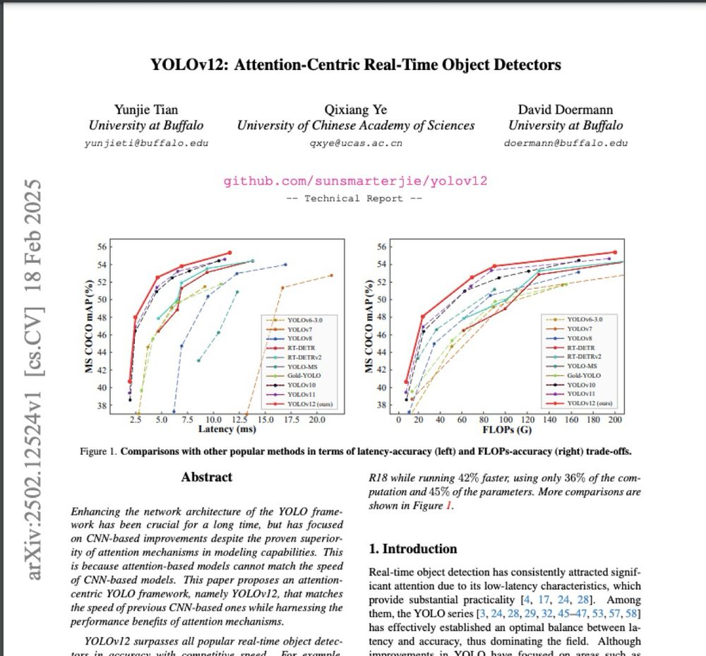
The newest of the Object detection models, YOLOv12; an attention centric YOLO framework
The newest of the Object detection models, YOLOv12; an attention centric YOLO framework
February 25, 2025 at 5:22 AM
Enter ML, using previous annotations/digitization & the satellite imagery that served as the basis for Object detection model such as YOLO, DETR etc
The newest of the Object detection models, YOLOv12; an attention centric YOLO framework
The newest of the Object detection models, YOLOv12; an attention centric YOLO framework
-To detemine the amount of area covered by trees
-To establish change over time of forested areas
-To determine rate of deforestation etc
All the three objectives above could be climate related or agriculture related to help various stakeholders understand changes & their impact
-To establish change over time of forested areas
-To determine rate of deforestation etc
All the three objectives above could be climate related or agriculture related to help various stakeholders understand changes & their impact
February 25, 2025 at 5:22 AM
-To detemine the amount of area covered by trees
-To establish change over time of forested areas
-To determine rate of deforestation etc
All the three objectives above could be climate related or agriculture related to help various stakeholders understand changes & their impact
-To establish change over time of forested areas
-To determine rate of deforestation etc
All the three objectives above could be climate related or agriculture related to help various stakeholders understand changes & their impact
Digitization using GIS skills helped in extracting features faster but it is a monotonous, mind numbing task. Clicking on a screen to extract trees or forested areas in an satellite imagery of Nairobi would take several days while being done by several people
Why get the data you ask?
Why get the data you ask?

February 25, 2025 at 5:22 AM
Digitization using GIS skills helped in extracting features faster but it is a monotonous, mind numbing task. Clicking on a screen to extract trees or forested areas in an satellite imagery of Nairobi would take several days while being done by several people
Why get the data you ask?
Why get the data you ask?
Traditionally, without digitization in GIS, a surveyor would go to the ground & carry out a topographical survey picking the location of various features but with large areas, this would take years to complete meaning that changes would have occurred making data outdated fast
February 25, 2025 at 5:22 AM
Traditionally, without digitization in GIS, a surveyor would go to the ground & carry out a topographical survey picking the location of various features but with large areas, this would take years to complete meaning that changes would have occurred making data outdated fast
Data annotation is one of the most important tasks for Machine Learning. Annotation involves creating labels and therefore meaning for various data types, essentially digitizing
In Geospatial technologies: features digitization to create shapefiles for maps, spatial analysis etc
In Geospatial technologies: features digitization to create shapefiles for maps, spatial analysis etc
February 25, 2025 at 5:22 AM
Data annotation is one of the most important tasks for Machine Learning. Annotation involves creating labels and therefore meaning for various data types, essentially digitizing
In Geospatial technologies: features digitization to create shapefiles for maps, spatial analysis etc
In Geospatial technologies: features digitization to create shapefiles for maps, spatial analysis etc
It was truly interesting to discover abt this model & dataset from the Google SSA bootcamp Future of AI in Africa talk and I look forward to tinkering with it
February 21, 2025 at 11:57 AM
It was truly interesting to discover abt this model & dataset from the Google SSA bootcamp Future of AI in Africa talk and I look forward to tinkering with it