


Reposted by Vishu Nandigam
Please join OpenTopo's Chelsea Scott & Cassandra Brigham for a WHPC@SDSC Professional Speaker Series talk.
Topographic change with OpenTopography: Adventures in cloud computing, spatial uncertainty, and impactful applications
Feb. 25, 2026 at 1–2 pm PT
Register: www.sdsc.edu/events/20260...
Topographic change with OpenTopography: Adventures in cloud computing, spatial uncertainty, and impactful applications
Feb. 25, 2026 at 1–2 pm PT
Register: www.sdsc.edu/events/20260...

January 7, 2026 at 8:06 PM
Please join OpenTopo's Chelsea Scott & Cassandra Brigham for a WHPC@SDSC Professional Speaker Series talk.
Topographic change with OpenTopography: Adventures in cloud computing, spatial uncertainty, and impactful applications
Feb. 25, 2026 at 1–2 pm PT
Register: www.sdsc.edu/events/20260...
Topographic change with OpenTopography: Adventures in cloud computing, spatial uncertainty, and impactful applications
Feb. 25, 2026 at 1–2 pm PT
Register: www.sdsc.edu/events/20260...
Reposted by Vishu Nandigam

Join us at our #AGU25 poster to discover how we harnesses airborne & satellite #lidar data using advanced workflows to uncover powerful insights on forest structure, biomass, and how landscapes change over time. agu.confex.com/agu/agu25/me...
#OpenScience #WildfireRecovery #EcosystemChange #RStats
#OpenScience #WildfireRecovery #EcosystemChange #RStats

December 10, 2025 at 4:09 PM
Join us at our #AGU25 poster to discover how we harnesses airborne & satellite #lidar data using advanced workflows to uncover powerful insights on forest structure, biomass, and how landscapes change over time. agu.confex.com/agu/agu25/me...
#OpenScience #WildfireRecovery #EcosystemChange #RStats
#OpenScience #WildfireRecovery #EcosystemChange #RStats
Reposted by Vishu Nandigam
Connect with OpenTopography at #AGU25 in New Orleans next week! Our booth (908) is staffed by the OT team and is a great chance to ask questions, provide feedback, or to discuss lidar, high resolution topography, and cyberinfrastructure.
opentopography.org/news/opentop...
opentopography.org/news/opentop...

December 9, 2025 at 3:02 PM
Connect with OpenTopography at #AGU25 in New Orleans next week! Our booth (908) is staffed by the OT team and is a great chance to ask questions, provide feedback, or to discuss lidar, high resolution topography, and cyberinfrastructure.
opentopography.org/news/opentop...
opentopography.org/news/opentop...
Reposted by Vishu Nandigam
Stop by our #AGU25 poster-showcasing our #GoogleEarthEngine app that fuses NASA ICESat‑2 & GEDI #lidar with Sentinel‑1 SAR & Landsat‑8 using machine learning to map 30 m canopy height & biomass, achieving ~6 m RMSE in a hurricane‑impacted Florida case study. agu.confex.com/agu/agu25/me... #ICESat2

December 9, 2025 at 4:18 PM
Stop by our #AGU25 poster-showcasing our #GoogleEarthEngine app that fuses NASA ICESat‑2 & GEDI #lidar with Sentinel‑1 SAR & Landsat‑8 using machine learning to map 30 m canopy height & biomass, achieving ~6 m RMSE in a hurricane‑impacted Florida case study. agu.confex.com/agu/agu25/me... #ICESat2
Reposted by Vishu Nandigam
Discover how #lidar reveals wildfire impacts & landscape recovery. Case studies in Arizona & Los Angeles show how 3D data helps us quantify canopy loss, hazards, & restoration after major fires. #LAfires #Kaibab
Watch the new #wildfire science video: www.youtube.com/watch?v=7Joz...
Watch the new #wildfire science video: www.youtube.com/watch?v=7Joz...

Measuring Wildfire Impact: Lidar Analysis of Arizona and California Fires
YouTube video by OpenForest4D
www.youtube.com
December 4, 2025 at 3:28 PM
Discover how #lidar reveals wildfire impacts & landscape recovery. Case studies in Arizona & Los Angeles show how 3D data helps us quantify canopy loss, hazards, & restoration after major fires. #LAfires #Kaibab
Watch the new #wildfire science video: www.youtube.com/watch?v=7Joz...
Watch the new #wildfire science video: www.youtube.com/watch?v=7Joz...
Reposted by Vishu Nandigam
Generate #forestry products from #lidar topography data with lidR! Reproducible R notebook guides users through #pointcloud filtering, raster generation & forest metrics extraction to produce key outputs like canopy height models. Explore notebook: github.com/OpenForest4D...
#googlecolab #geospatial
#googlecolab #geospatial


December 1, 2025 at 7:22 PM
Generate #forestry products from #lidar topography data with lidR! Reproducible R notebook guides users through #pointcloud filtering, raster generation & forest metrics extraction to produce key outputs like canopy height models. Explore notebook: github.com/OpenForest4D...
#googlecolab #geospatial
#googlecolab #geospatial
Reposted by Vishu Nandigam
We created an #OpenSource automated workflow for multi-temporal #lidar processing to map forest change at scale. Generate canopy height, cover & change products critical for monitoring #wildfire impacts and ecosystem dynamics. Code and example from #Kaibab forest #AZ at github.com/OpenForest4D...

November 5, 2025 at 6:23 PM
We created an #OpenSource automated workflow for multi-temporal #lidar processing to map forest change at scale. Generate canopy height, cover & change products critical for monitoring #wildfire impacts and ecosystem dynamics. Code and example from #Kaibab forest #AZ at github.com/OpenForest4D...
Reposted by Vishu Nandigam
For the last several decades, scientists have been developing a way to make our maps more reliable with point cloud data collected by lidar. Lidar is an accurate method that helps scientists to map cities, landscapes, and places that were previously difficult or dangerous to access.
November 10, 2025 at 5:26 PM
For the last several decades, scientists have been developing a way to make our maps more reliable with point cloud data collected by lidar. Lidar is an accurate method that helps scientists to map cities, landscapes, and places that were previously difficult or dangerous to access.
Reposted by Vishu Nandigam
Discover how #lidar reveals the size & location of individual Ponderosa Pines at Sunset Crater, AZ! Using advanced algorithms in lidR, we map tree height and crowns in stunning detail, informing forest ecology and management.
openforest4d.org/tree-identif...
#Forestry
#RemoteSensing
#RStats
openforest4d.org/tree-identif...
#Forestry
#RemoteSensing
#RStats

October 30, 2025 at 3:41 PM
Discover how #lidar reveals the size & location of individual Ponderosa Pines at Sunset Crater, AZ! Using advanced algorithms in lidR, we map tree height and crowns in stunning detail, informing forest ecology and management.
openforest4d.org/tree-identif...
#Forestry
#RemoteSensing
#RStats
openforest4d.org/tree-identif...
#Forestry
#RemoteSensing
#RStats
Reposted by Vishu Nandigam
Ever wondered what #lidar point clouds reveal about forests? OpenForest4D’s new guide breaks down how elevation, return number, intensity, and classification describe forest structure.
openforest4d.org/lidar-point-...
#pointcloud #laserscanning #forestry #geospatial
openforest4d.org/lidar-point-...
#pointcloud #laserscanning #forestry #geospatial

October 27, 2025 at 4:33 PM
Ever wondered what #lidar point clouds reveal about forests? OpenForest4D’s new guide breaks down how elevation, return number, intensity, and classification describe forest structure.
openforest4d.org/lidar-point-...
#pointcloud #laserscanning #forestry #geospatial
openforest4d.org/lidar-point-...
#pointcloud #laserscanning #forestry #geospatial
Reposted by Vishu Nandigam
OT will be at GSA Connects 2025 in San Antonio, TX, Oct 19–22. Visit us at booth 809 to talk lidar, topography, and grab an "I ❤️ LIDAR" sticker. OT is honored to receive the 2025 GSA President’s Medal. Join us for the President’s Medal Lecture on Mon Oct. 20.
opentopography.org/news/opentop...
opentopography.org/news/opentop...

October 15, 2025 at 3:32 PM
OT will be at GSA Connects 2025 in San Antonio, TX, Oct 19–22. Visit us at booth 809 to talk lidar, topography, and grab an "I ❤️ LIDAR" sticker. OT is honored to receive the 2025 GSA President’s Medal. Join us for the President’s Medal Lecture on Mon Oct. 20.
opentopography.org/news/opentop...
opentopography.org/news/opentop...
Reposted by Vishu Nandigam
The White House Vision for Dismantling Science in One Simple Plot
(Proposed NIH, NSF, and NASA budgets would be catastrophic for innovation and discovery. But they aren’t reality yet. The time to speak up is now.)
joshuasweitz.substack.com/p/the-white-...
(Proposed NIH, NSF, and NASA budgets would be catastrophic for innovation and discovery. But they aren’t reality yet. The time to speak up is now.)
joshuasweitz.substack.com/p/the-white-...

May 31, 2025 at 2:38 PM
The White House Vision for Dismantling Science in One Simple Plot
(Proposed NIH, NSF, and NASA budgets would be catastrophic for innovation and discovery. But they aren’t reality yet. The time to speak up is now.)
joshuasweitz.substack.com/p/the-white-...
(Proposed NIH, NSF, and NASA budgets would be catastrophic for innovation and discovery. But they aren’t reality yet. The time to speak up is now.)
joshuasweitz.substack.com/p/the-white-...
Reposted by Vishu Nandigam
Effective immediately, the PGC is no longer accepting new NSF-supported requests due to a lack of renewal funding. Current work is wrapping up. Please contact your NSF program officer if impacted. We’re grateful to have supported your polar research. Read our full statement at www.pgc.umn.edu
May 5, 2025 at 9:33 PM
Effective immediately, the PGC is no longer accepting new NSF-supported requests due to a lack of renewal funding. Current work is wrapping up. Please contact your NSF program officer if impacted. We’re grateful to have supported your polar research. Read our full statement at www.pgc.umn.edu
Reposted by Vishu Nandigam
Lidar is reshaping how utilities plan, build, and protect infrastructure. From optimizing wind and solar farms to assessing wildfire risks, high resolution topography is critical for developing more resilient infrastructure.
Read more about lidar and utilities: opentopography.org/blog/utility...
Read more about lidar and utilities: opentopography.org/blog/utility...


April 28, 2025 at 8:13 PM
Lidar is reshaping how utilities plan, build, and protect infrastructure. From optimizing wind and solar farms to assessing wildfire risks, high resolution topography is critical for developing more resilient infrastructure.
Read more about lidar and utilities: opentopography.org/blog/utility...
Read more about lidar and utilities: opentopography.org/blog/utility...
Reposted by Vishu Nandigam
Why do humans face so many health challenges? Discover the answers at our virtual symposium, “Mismatch: Human Origins and Modern Disease”! 👣🚑
Date: Friday, May 16, 2025
Time: 10:00 AM – 2:30 PM (Pacific Time)
Register & Watch Live: carta.anthropogeny.org
Date: Friday, May 16, 2025
Time: 10:00 AM – 2:30 PM (Pacific Time)
Register & Watch Live: carta.anthropogeny.org
March 26, 2025 at 6:05 PM
Why do humans face so many health challenges? Discover the answers at our virtual symposium, “Mismatch: Human Origins and Modern Disease”! 👣🚑
Date: Friday, May 16, 2025
Time: 10:00 AM – 2:30 PM (Pacific Time)
Register & Watch Live: carta.anthropogeny.org
Date: Friday, May 16, 2025
Time: 10:00 AM – 2:30 PM (Pacific Time)
Register & Watch Live: carta.anthropogeny.org
Reposted by Vishu Nandigam
Join us for the FREE OpenTopography Spring Webinar Series. Four weekly hour-long webinars starting March 5th. We'll provide an overview of OpenTopography, high resolution topography (#lidar), and OpenTopography's processing tools. Registration & more information: opentopography.org/news/2025-we...

February 26, 2025 at 3:11 PM
Join us for the FREE OpenTopography Spring Webinar Series. Four weekly hour-long webinars starting March 5th. We'll provide an overview of OpenTopography, high resolution topography (#lidar), and OpenTopography's processing tools. Registration & more information: opentopography.org/news/2025-we...
Reposted by Vishu Nandigam
"I don't know what NSF is going to be now, but it's not more efficient. It's just a mess."
My story on today's firings and their impact.
www.npr.org/2025/02/18/n...
My story on today's firings and their impact.
www.npr.org/2025/02/18/n...

National Science Foundation fires roughly 10% of its workforce
NSF fired 168 employees, leaving the agency less equipped to fund a wide range of scientific research.
www.npr.org
February 19, 2025 at 12:15 AM
"I don't know what NSF is going to be now, but it's not more efficient. It's just a mess."
My story on today's firings and their impact.
www.npr.org/2025/02/18/n...
My story on today's firings and their impact.
www.npr.org/2025/02/18/n...
Reposted by Vishu Nandigam
It is time for all of our societies to speak up about this attack on US science.
Speak now, please!
@agu.org
@nationalacademies.org
@igsoc.bsky.social
Speak now, please!
@agu.org
@nationalacademies.org
@igsoc.bsky.social

The Planetary Society strongly opposes the sudden, indiscriminate dismissal of more than 1,000 scientists, engineers, and explorers at NASA — the largest involuntary workforce reduction since the end of the Apollo program.
Read more on our stance. ⬇️
Read more on our stance. ⬇️
The Planetary Society Strongly Opposes Mass Layoffs of Probationary…
Sudden, indiscriminate layoffs at NASA do not serve the national interests in space leadership.
www.planetary.org
February 18, 2025 at 8:50 PM
It is time for all of our societies to speak up about this attack on US science.
Speak now, please!
@agu.org
@nationalacademies.org
@igsoc.bsky.social
Speak now, please!
@agu.org
@nationalacademies.org
@igsoc.bsky.social
Reposted by Vishu Nandigam

Incompetence in Washington puts every American at risk, no matter how you voted. No one should be happy that the DOGE team - the same folks who randomly published classified U.S. security information online today - wants access to your bank account & Social Security numbers.
February 15, 2025 at 3:26 AM
Incompetence in Washington puts every American at risk, no matter how you voted. No one should be happy that the DOGE team - the same folks who randomly published classified U.S. security information online today - wants access to your bank account & Social Security numbers.
Reposted by Vishu Nandigam
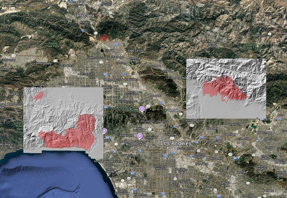
Using #lidar to understand the impacts of the 2025 Palisades and Eaton Fires, Los Angeles, CA: We processed pre- & post- fire lidar data to illustrate the changes to the natural and built environments caused by these devastating fires. Blog for more info & images: opentopography.org/blog/using-l...


February 11, 2025 at 3:55 PM
Using #lidar to understand the impacts of the 2025 Palisades and Eaton Fires, Los Angeles, CA: We processed pre- & post- fire lidar data to illustrate the changes to the natural and built environments caused by these devastating fires. Blog for more info & images: opentopography.org/blog/using-l...
New NSF funded initiative to advance the mapping and monitoring of global forest ecosystems by on-demand generation of research-grade estimates of forest structure and above-ground biomass using the latest multi-source remote sensing data. today.ucsd.edu/story/resear... #ForestScience #lidar #AI

Researchers Awarded $3M NSF Grant for Next-Generation Forest Mapping and Monitoring
Researchers at the University of California San Diego, University of Florida and Arizona State University have been awarded $3.28 million from the U.S. National Science Foundation (NSF) to build OpenF...
today.ucsd.edu
January 15, 2025 at 10:50 PM
New NSF funded initiative to advance the mapping and monitoring of global forest ecosystems by on-demand generation of research-grade estimates of forest structure and above-ground biomass using the latest multi-source remote sensing data. today.ucsd.edu/story/resear... #ForestScience #lidar #AI
In response to the devastating Los Angeles wildfires, @opentopography.bsky.social is opening its discovery and processing services on pre-wildfire high resolution topography lidar data for Los Angeles County. opentopography.org/news/2025_LA...
January 14, 2025 at 10:35 PM
In response to the devastating Los Angeles wildfires, @opentopography.bsky.social is opening its discovery and processing services on pre-wildfire high resolution topography lidar data for Los Angeles County. opentopography.org/news/2025_LA...
Reposted by Vishu Nandigam
Day three of #AGU24. If you’ve not yet said hi to the OpenTopography team please stop by booth 1108 in the exhibit hall: opentopography.org/news/opentop...


December 11, 2024 at 2:48 PM
Day three of #AGU24. If you’ve not yet said hi to the OpenTopography team please stop by booth 1108 in the exhibit hall: opentopography.org/news/opentop...
Reposted by Vishu Nandigam
OT will be at #AGU24 next week. Visit us in booth #1108 in the exhibit hall. Our booth is staffed by the OT team. Stop by & ask questions, provide feedback, and see what's new in OT. We'll also have "I ❤️ #LIDAR" stickers!
More info on the OT booth, talks, posters: opentopography.org/news/opentop...
More info on the OT booth, talks, posters: opentopography.org/news/opentop...

December 6, 2024 at 3:21 PM
OT will be at #AGU24 next week. Visit us in booth #1108 in the exhibit hall. Our booth is staffed by the OT team. Stop by & ask questions, provide feedback, and see what's new in OT. We'll also have "I ❤️ #LIDAR" stickers!
More info on the OT booth, talks, posters: opentopography.org/news/opentop...
More info on the OT booth, talks, posters: opentopography.org/news/opentop...
Reposted by Vishu Nandigam
Are you interested in helping to guide OpenTopography? We're seeking members for our 3 Advisory Committees to represent users and ensure that the facility’s activities are aligned with the needs & initiatives of the scientific & educational communities: opentopography.org/news/new_ac_...
OpenTopography Seeks New Members for Advisory Committees | OpenTopography
OpenTopography is a science gateway that provides online access to Earth science oriented high resolution topography data, processing tools, and educational resources to support advancing our understanding of the Earth’s surface, vegetation, and built environment.
opentopography.org
November 25, 2024 at 7:52 PM
Are you interested in helping to guide OpenTopography? We're seeking members for our 3 Advisory Committees to represent users and ensure that the facility’s activities are aligned with the needs & initiatives of the scientific & educational communities: opentopography.org/news/new_ac_...