


MyRadar
@myradar.bsky.social
Keeping you ahead of the storm since 2008. Download for FREE! myradar.com
Concern is growing that Darwin could see significant freshwater flooding from Cyclone Fina.

November 20, 2025 at 9:31 PM
Concern is growing that Darwin could see significant freshwater flooding from Cyclone Fina.
Up to 10 inches of rain has fallen near Menard, Texas. Water is entering homes in the Harris Hollow section of town.

November 20, 2025 at 9:31 PM
Up to 10 inches of rain has fallen near Menard, Texas. Water is entering homes in the Harris Hollow section of town.
Yikes! Dust Storm Warning for Midland-Odessa and points east along I-20.
60 mph gusts lofting dust will reduce visibilities below a quarter mile.
60 mph gusts lofting dust will reduce visibilities below a quarter mile.


November 20, 2025 at 9:29 PM
Yikes! Dust Storm Warning for Midland-Odessa and points east along I-20.
60 mph gusts lofting dust will reduce visibilities below a quarter mile.
60 mph gusts lofting dust will reduce visibilities below a quarter mile.
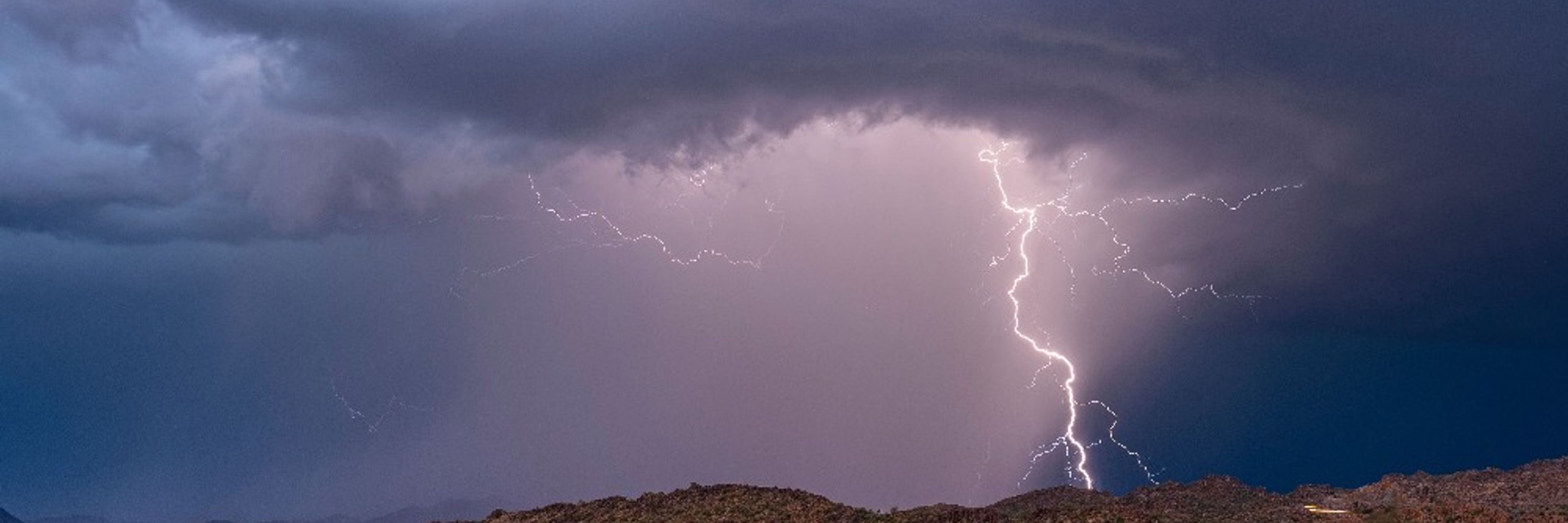
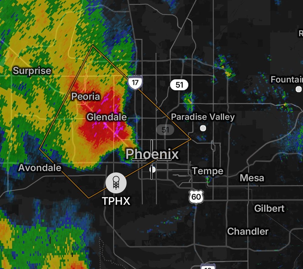
Quarter-sized hail with a severe thunderstorm in the northwest Phoenix metro.
November 20, 2025 at 12:31 AM
Quarter-sized hail with a severe thunderstorm in the northwest Phoenix metro.
A flood watch remains is effect in Hill Country through Thursday night.
Keep in mind that rainfall totals will vary significantly over short distances... AND the topography could funnel water/locally enhance flooding.
Keep in mind that rainfall totals will vary significantly over short distances... AND the topography could funnel water/locally enhance flooding.

November 19, 2025 at 6:35 PM
A flood watch remains is effect in Hill Country through Thursday night.
Keep in mind that rainfall totals will vary significantly over short distances... AND the topography could funnel water/locally enhance flooding.
Keep in mind that rainfall totals will vary significantly over short distances... AND the topography could funnel water/locally enhance flooding.
In Texas, isolated severe weather is possible.
Thunderstorm fuel is sufficient to brew a couple severe storms that grow tall enough to "feel" the jet stream.
Those storms may mix jet stream momentum to the surface in the form of locally damaging gusts.
Thunderstorm fuel is sufficient to brew a couple severe storms that grow tall enough to "feel" the jet stream.
Those storms may mix jet stream momentum to the surface in the form of locally damaging gusts.

November 19, 2025 at 6:34 PM
In Texas, isolated severe weather is possible.
Thunderstorm fuel is sufficient to brew a couple severe storms that grow tall enough to "feel" the jet stream.
Those storms may mix jet stream momentum to the surface in the form of locally damaging gusts.
Thunderstorm fuel is sufficient to brew a couple severe storms that grow tall enough to "feel" the jet stream.
Those storms may mix jet stream momentum to the surface in the form of locally damaging gusts.
Hefty rainfall totals in Texas over these next 36 hours. Confidence is increasing in a corridor of 4+ inches of rain, perhaps around Brownwood, Brady, Fredericksburg, Junction, Menard or nearby in Hill Country. A localized 6-7 inch zone can't be ruled out.

November 19, 2025 at 6:30 PM
Hefty rainfall totals in Texas over these next 36 hours. Confidence is increasing in a corridor of 4+ inches of rain, perhaps around Brownwood, Brady, Fredericksburg, Junction, Menard or nearby in Hill Country. A localized 6-7 inch zone can't be ruled out.
One thing fostering heavier rainfall in Texas this evening and Thursday will be divergence, or spreading of the air aloft.
That spreading upstairs creates a vacuum effect of sorts that lifts air (and moisture) from below.
That moisture then falls as extra-heavy rain.
That spreading upstairs creates a vacuum effect of sorts that lifts air (and moisture) from below.
That moisture then falls as extra-heavy rain.

November 19, 2025 at 6:28 PM
One thing fostering heavier rainfall in Texas this evening and Thursday will be divergence, or spreading of the air aloft.
That spreading upstairs creates a vacuum effect of sorts that lifts air (and moisture) from below.
That moisture then falls as extra-heavy rain.
That spreading upstairs creates a vacuum effect of sorts that lifts air (and moisture) from below.
That moisture then falls as extra-heavy rain.
Increasing risk of scattered flooding in central Texas between Wednesday evening and Friday morning:

November 18, 2025 at 7:37 PM
Increasing risk of scattered flooding in central Texas between Wednesday evening and Friday morning:
NEW: There is an increasing risk of a couple supercells, with isolated tornado potential, from northwest Tennessee and western Kentucky to southern Illinois and Indiana and southeast Missouri.
More heating than initially anticipated is leading to a bit more available storm fuel.
More heating than initially anticipated is leading to a bit more available storm fuel.

November 18, 2025 at 6:09 PM
NEW: There is an increasing risk of a couple supercells, with isolated tornado potential, from northwest Tennessee and western Kentucky to southern Illinois and Indiana and southeast Missouri.
More heating than initially anticipated is leading to a bit more available storm fuel.
More heating than initially anticipated is leading to a bit more available storm fuel.
Polar night has arrived in Utqiagvik, Alaska, the nation's northernmost town. The sun was slated to set at 1:36 p.m. Tuesday afternoon, and won’t return until January 22.

November 18, 2025 at 3:43 PM
Polar night has arrived in Utqiagvik, Alaska, the nation's northernmost town. The sun was slated to set at 1:36 p.m. Tuesday afternoon, and won’t return until January 22.
TUESDAY, November 18th could feature a few locally severe storms in southern Illinois, southern Indiana, western Kentucky, the Missouri Bootheel or extreme northwest Tennessee.
A warm front lifting north will induce some low-level vorticity, or twist, and a few thunderstorms will form near a low.
A warm front lifting north will induce some low-level vorticity, or twist, and a few thunderstorms will form near a low.

November 17, 2025 at 7:34 PM
TUESDAY, November 18th could feature a few locally severe storms in southern Illinois, southern Indiana, western Kentucky, the Missouri Bootheel or extreme northwest Tennessee.
A warm front lifting north will induce some low-level vorticity, or twist, and a few thunderstorms will form near a low.
A warm front lifting north will induce some low-level vorticity, or twist, and a few thunderstorms will form near a low.
November 17, 2025 at 7:34 PM
TUESDAY, November 18th could feature a few locally severe storms in southern Illinois, southern Indiana, western Kentucky, the Missouri Bootheel or extreme northwest Tennessee.
A warm front lifting north will induce some low-level vorticity, or twist, and a few thunderstorms will form near a low.
A warm front lifting north will induce some low-level vorticity, or twist, and a few thunderstorms will form near a low.
The same storms yielded 19 reports of winds over 75 mph. There was also large to giant hail – softball-sized hail (4 inches) fell in Bloomington!

November 17, 2025 at 3:55 PM
The same storms yielded 19 reports of winds over 75 mph. There was also large to giant hail – softball-sized hail (4 inches) fell in Bloomington!
The other EF4 hit Washington *county*, passing through New Minden and Hoyleton and killing two people. It tracked 10.59 miles in just over 9 minutes. That means it had an incredible forward speed fo 60 to 70 mph!

November 17, 2025 at 3:55 PM
The other EF4 hit Washington *county*, passing through New Minden and Hoyleton and killing two people. It tracked 10.59 miles in just over 9 minutes. That means it had an incredible forward speed fo 60 to 70 mph!
The outbreak produced 77 tornadoes, including two EF4s in Illinois. One touched down just east of East Peoria and then hit Washington, Ill. (Tazewell County) with winds over 190 mph. It tracked 46.4 miles and killed three people.

November 17, 2025 at 3:55 PM
The outbreak produced 77 tornadoes, including two EF4s in Illinois. One touched down just east of East Peoria and then hit Washington, Ill. (Tazewell County) with winds over 190 mph. It tracked 46.4 miles and killed three people.
On this date in 2013, a top-tier tornado outbreak tore through Illinois and Indiana. SPC had issued a rare high risk – a level 5 out of 5 – of severe weather, and was anticipating initial rotating supercells that would spawn tornadoes and then merge into a destructive wind-producing squall line.
November 17, 2025 at 3:55 PM
On this date in 2013, a top-tier tornado outbreak tore through Illinois and Indiana. SPC had issued a rare high risk – a level 5 out of 5 – of severe weather, and was anticipating initial rotating supercells that would spawn tornadoes and then merge into a destructive wind-producing squall line.
A hefty dose of moisture in southern California with this next atmospheric river... but it could even bring some flooding.

November 14, 2025 at 4:21 PM
A hefty dose of moisture in southern California with this next atmospheric river... but it could even bring some flooding.
An atmospheric river will soak central and southern California over the next several days, with the heaviest beginning Saturday morning.
2 to 3 inches of rain is possible in Southern California, with 2-3 FEET+ of snow in the Sierra Nevada above 6,000 feet!
2 to 3 inches of rain is possible in Southern California, with 2-3 FEET+ of snow in the Sierra Nevada above 6,000 feet!
November 14, 2025 at 4:20 PM
An atmospheric river will soak central and southern California over the next several days, with the heaviest beginning Saturday morning.
2 to 3 inches of rain is possible in Southern California, with 2-3 FEET+ of snow in the Sierra Nevada above 6,000 feet!
2 to 3 inches of rain is possible in Southern California, with 2-3 FEET+ of snow in the Sierra Nevada above 6,000 feet!
The sunspot that gave us epic auroral displays is finally rotating away from us – but not before spewing another big flare.
This one's associated energetic shockwave (coronal mass ejection) is likely aimed away from us, so it won't cause more big geomagnetic storms.
This one's associated energetic shockwave (coronal mass ejection) is likely aimed away from us, so it won't cause more big geomagnetic storms.

November 14, 2025 at 1:45 PM
The sunspot that gave us epic auroral displays is finally rotating away from us – but not before spewing another big flare.
This one's associated energetic shockwave (coronal mass ejection) is likely aimed away from us, so it won't cause more big geomagnetic storms.
This one's associated energetic shockwave (coronal mass ejection) is likely aimed away from us, so it won't cause more big geomagnetic storms.
8:30 PM ET Aurora update:


November 13, 2025 at 1:26 AM
8:30 PM ET Aurora update:
Believe it or not, there is actually a science behind what the aurora will visibly look like at your location IF a high-end geomagnetic storm materializes as forecast:

November 12, 2025 at 6:44 PM
Believe it or not, there is actually a science behind what the aurora will visibly look like at your location IF a high-end geomagnetic storm materializes as forecast:

The potential exists for a severe or extreme geomagnetic storm tonight!

November 12, 2025 at 2:25 PM
The potential exists for a severe or extreme geomagnetic storm tonight!