


Mike Wulder
@mikewulder.bsky.social
Senior Research Scientist with the Canadian Forest Service. 🍁
#Landsat super-fan. #Lidar. #Forests. #Remotesensing. 🌲🛰
Member of the #OrderOfCanada. 🎖
📎https://www.researchgate.net/profile/Michael-Wulder
#Landsat super-fan. #Lidar. #Forests. #Remotesensing. 🌲🛰
Member of the #OrderOfCanada. 🎖
📎https://www.researchgate.net/profile/Michael-Wulder
White et al. Enhanced forest inventories in Canada: implementation, status, and research needs. #EFI
➡️ Airborne Laser Scanning (ALS) is operational for forest inventory in Canada enabling EFIs.
➡️ Coverage exceeds 66% of Canada’s managed forest area (~230 million ha). #lidar
🔗 doi.org/10.1139/cjfr...
➡️ Airborne Laser Scanning (ALS) is operational for forest inventory in Canada enabling EFIs.
➡️ Coverage exceeds 66% of Canada’s managed forest area (~230 million ha). #lidar
🔗 doi.org/10.1139/cjfr...

September 10, 2025 at 8:23 PM
White et al. Enhanced forest inventories in Canada: implementation, status, and research needs. #EFI
➡️ Airborne Laser Scanning (ALS) is operational for forest inventory in Canada enabling EFIs.
➡️ Coverage exceeds 66% of Canada’s managed forest area (~230 million ha). #lidar
🔗 doi.org/10.1139/cjfr...
➡️ Airborne Laser Scanning (ALS) is operational for forest inventory in Canada enabling EFIs.
➡️ Coverage exceeds 66% of Canada’s managed forest area (~230 million ha). #lidar
🔗 doi.org/10.1139/cjfr...
Canada's Satellite-Based Forest Inventory uses image segmentation to create stand-level maps for forest science & monitoring, including tree species & biomass. #SBFI
Paper: doi.org/10.1093/fore...
Download data opendata.nfis.org/mapserver/nf...
Data on #GEE: gee-community-catalog.org/projects/ca_...
Paper: doi.org/10.1093/fore...
Download data opendata.nfis.org/mapserver/nf...
Data on #GEE: gee-community-catalog.org/projects/ca_...
August 22, 2025 at 10:30 PM
Canada's Satellite-Based Forest Inventory uses image segmentation to create stand-level maps for forest science & monitoring, including tree species & biomass. #SBFI
Paper: doi.org/10.1093/fore...
Download data opendata.nfis.org/mapserver/nf...
Data on #GEE: gee-community-catalog.org/projects/ca_...
Paper: doi.org/10.1093/fore...
Download data opendata.nfis.org/mapserver/nf...
Data on #GEE: gee-community-catalog.org/projects/ca_...
Me and Nicholas Coops! 😎
Invited to participate in @irssubc.bsky.social lab retreat at Cowichan Lake Research Station.
Forests and remote sensing, so much great science in IRSS!
Invited to participate in @irssubc.bsky.social lab retreat at Cowichan Lake Research Station.
Forests and remote sensing, so much great science in IRSS!

August 13, 2025 at 8:39 PM
Me and Nicholas Coops! 😎
Invited to participate in @irssubc.bsky.social lab retreat at Cowichan Lake Research Station.
Forests and remote sensing, so much great science in IRSS!
Invited to participate in @irssubc.bsky.social lab retreat at Cowichan Lake Research Station.
Forests and remote sensing, so much great science in IRSS!
Waite et al. (2025) find that heat & drought affect Douglas‑fir red‑edge spectral indices differently by tree size—mature trees show steeper red‑edge declines mid‑drought than saplings. #UAV #Lidar #multispectral #openaccess
doi.org/10.1016/j.sr...
doi.org/10.1016/j.sr...

July 16, 2025 at 7:46 PM
Waite et al. (2025) find that heat & drought affect Douglas‑fir red‑edge spectral indices differently by tree size—mature trees show steeper red‑edge declines mid‑drought than saplings. #UAV #Lidar #multispectral #openaccess
doi.org/10.1016/j.sr...
doi.org/10.1016/j.sr...
We tested ways to improve Canada’s National Forest Inventory (#NFI) estimates by integrating #Landsat derived #landcover data. Combining sample-based plots with wall-to-wall maps boosted estimation efficiency and helped track tree cover change. #OpenAccess #NTEMS
Baral et al. doi.org/10.1139/cjfr...
Baral et al. doi.org/10.1139/cjfr...
July 14, 2025 at 7:05 PM
We tested ways to improve Canada’s National Forest Inventory (#NFI) estimates by integrating #Landsat derived #landcover data. Combining sample-based plots with wall-to-wall maps boosted estimation efficiency and helped track tree cover change. #OpenAccess #NTEMS
Baral et al. doi.org/10.1139/cjfr...
Baral et al. doi.org/10.1139/cjfr...
Great idea! While not a paper, a terrific resource is the book Landsat's Enduring Legacy: Pioneering Global Land Observations from Space.
Bit of everything. History of remote sensing. System design. Orbits. Applications. Has it all, AND is #openaccess!
Get a free copy: my.asprs.org/common/Uploa...
Bit of everything. History of remote sensing. System design. Orbits. Applications. Has it all, AND is #openaccess!
Get a free copy: my.asprs.org/common/Uploa...
June 17, 2025 at 10:12 PM
Great idea! While not a paper, a terrific resource is the book Landsat's Enduring Legacy: Pioneering Global Land Observations from Space.
Bit of everything. History of remote sensing. System design. Orbits. Applications. Has it all, AND is #openaccess!
Get a free copy: my.asprs.org/common/Uploa...
Bit of everything. History of remote sensing. System design. Orbits. Applications. Has it all, AND is #openaccess!
Get a free copy: my.asprs.org/common/Uploa...
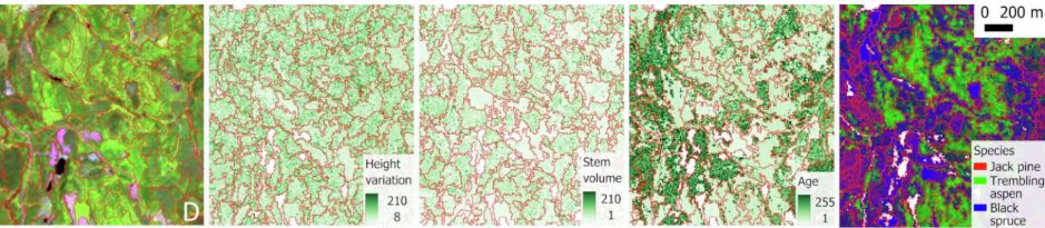
NEW! Title captures science well. 👇
Ye et al. A multi-resolution forest stand segmentation algorithm integrating Landsat imagery and forest structural, age, and species attributes.
@irssubc.bsky.social #Landsat #landcover #NTEMS
#OpenAccess: www.sciencedirect.com/science/arti...
Ye et al. A multi-resolution forest stand segmentation algorithm integrating Landsat imagery and forest structural, age, and species attributes.
@irssubc.bsky.social #Landsat #landcover #NTEMS
#OpenAccess: www.sciencedirect.com/science/arti...
May 30, 2025 at 10:20 PM
NEW! Title captures science well. 👇
Ye et al. A multi-resolution forest stand segmentation algorithm integrating Landsat imagery and forest structural, age, and species attributes.
@irssubc.bsky.social #Landsat #landcover #NTEMS
#OpenAccess: www.sciencedirect.com/science/arti...
Ye et al. A multi-resolution forest stand segmentation algorithm integrating Landsat imagery and forest structural, age, and species attributes.
@irssubc.bsky.social #Landsat #landcover #NTEMS
#OpenAccess: www.sciencedirect.com/science/arti...
Are you working on #Landsat or #Sentinel2 for mapping change or attributes (#landcover, #biomass, #species) over large areas and long time periods?
So many options! We share the science behind the National Terrestrial Ecosystem Monitoring System (#NTEMS) here:
www.researchgate.net/publication/...
So many options! We share the science behind the National Terrestrial Ecosystem Monitoring System (#NTEMS) here:
www.researchgate.net/publication/...

May 26, 2025 at 7:56 PM
Are you working on #Landsat or #Sentinel2 for mapping change or attributes (#landcover, #biomass, #species) over large areas and long time periods?
So many options! We share the science behind the National Terrestrial Ecosystem Monitoring System (#NTEMS) here:
www.researchgate.net/publication/...
So many options! We share the science behind the National Terrestrial Ecosystem Monitoring System (#NTEMS) here:
www.researchgate.net/publication/...
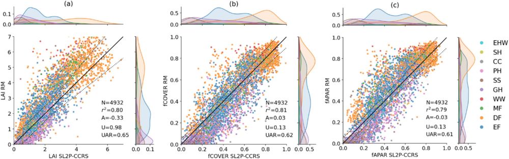
Stability of biophysical products indicates can quantify the physical response of vegetation to climate variability, disturbances & regeneration. 🏆
Djamai et al. On the consistency and stability of vegetation biophysical variables retrievals from #Landsat 8/9 and #Sentinel2.
doi.org/10.1016/j.is...
Djamai et al. On the consistency and stability of vegetation biophysical variables retrievals from #Landsat 8/9 and #Sentinel2.
doi.org/10.1016/j.is...
May 21, 2025 at 5:47 PM
Stability of biophysical products indicates can quantify the physical response of vegetation to climate variability, disturbances & regeneration. 🏆
Djamai et al. On the consistency and stability of vegetation biophysical variables retrievals from #Landsat 8/9 and #Sentinel2.
doi.org/10.1016/j.is...
Djamai et al. On the consistency and stability of vegetation biophysical variables retrievals from #Landsat 8/9 and #Sentinel2.
doi.org/10.1016/j.is...
Ma et al. Satellite canopy water content from #Sentinel2, #Landsat 8 and MODIS: Principle, algorithm and assessment.
-sensor independent algorithm for CWC from optical satellites is developed. #PROSAIL
-ground validation, inter-comparison at different scales is conducted.
doi.org/10.1016/j.rs...
-sensor independent algorithm for CWC from optical satellites is developed. #PROSAIL
-ground validation, inter-comparison at different scales is conducted.
doi.org/10.1016/j.rs...

May 20, 2025 at 11:38 PM
Ma et al. Satellite canopy water content from #Sentinel2, #Landsat 8 and MODIS: Principle, algorithm and assessment.
-sensor independent algorithm for CWC from optical satellites is developed. #PROSAIL
-ground validation, inter-comparison at different scales is conducted.
doi.org/10.1016/j.rs...
-sensor independent algorithm for CWC from optical satellites is developed. #PROSAIL
-ground validation, inter-comparison at different scales is conducted.
doi.org/10.1016/j.rs...
🛰️ Ever wonder how classification errors in remote sensing derived maps influence area estimates in stratified random sampling? 🤔
A new study explores the impact of map accuracy on area estimation and offers methods to mitigate biases.
#landcover @umdgeography.bsky.social
🔗 doi.org/10.1016/j.rs...
A new study explores the impact of map accuracy on area estimation and offers methods to mitigate biases.
#landcover @umdgeography.bsky.social
🔗 doi.org/10.1016/j.rs...

May 14, 2025 at 4:34 PM
🛰️ Ever wonder how classification errors in remote sensing derived maps influence area estimates in stratified random sampling? 🤔
A new study explores the impact of map accuracy on area estimation and offers methods to mitigate biases.
#landcover @umdgeography.bsky.social
🔗 doi.org/10.1016/j.rs...
A new study explores the impact of map accuracy on area estimation and offers methods to mitigate biases.
#landcover @umdgeography.bsky.social
🔗 doi.org/10.1016/j.rs...
Announcement: Remote Sensing of Environment, Special Issue:
➡️Development, Validation, and Application of Medium- and High-Resolution Satellite Products at Regional to Global Scales
Builds on Radeloff et al. 2024 (113918) data products review in RSE.
Details: www.sciencedirect.com/special-issu...
➡️Development, Validation, and Application of Medium- and High-Resolution Satellite Products at Regional to Global Scales
Builds on Radeloff et al. 2024 (113918) data products review in RSE.
Details: www.sciencedirect.com/special-issu...
May 6, 2025 at 8:23 PM
Announcement: Remote Sensing of Environment, Special Issue:
➡️Development, Validation, and Application of Medium- and High-Resolution Satellite Products at Regional to Global Scales
Builds on Radeloff et al. 2024 (113918) data products review in RSE.
Details: www.sciencedirect.com/special-issu...
➡️Development, Validation, and Application of Medium- and High-Resolution Satellite Products at Regional to Global Scales
Builds on Radeloff et al. 2024 (113918) data products review in RSE.
Details: www.sciencedirect.com/special-issu...
Ju et al. 2025. The Harmonized #Landsat and #Sentinel2 version 2 . 0 surface reflectance dataset. #RSE #HLS
www.sciencedirect.com/science/arti...
-available on cloud; global coverage at 30 m from 2013.
-Improvements in geolocation, atmospheric correction, cloud masking, & BRDF correction (NBAR). 🤩
www.sciencedirect.com/science/arti...
-available on cloud; global coverage at 30 m from 2013.
-Improvements in geolocation, atmospheric correction, cloud masking, & BRDF correction (NBAR). 🤩

April 30, 2025 at 5:11 PM
Ju et al. 2025. The Harmonized #Landsat and #Sentinel2 version 2 . 0 surface reflectance dataset. #RSE #HLS
www.sciencedirect.com/science/arti...
-available on cloud; global coverage at 30 m from 2013.
-Improvements in geolocation, atmospheric correction, cloud masking, & BRDF correction (NBAR). 🤩
www.sciencedirect.com/science/arti...
-available on cloud; global coverage at 30 m from 2013.
-Improvements in geolocation, atmospheric correction, cloud masking, & BRDF correction (NBAR). 🤩
Tyukavina et al. Practical global sampling methods for estimating area and map accuracy of #landcover and change.
Samples, pixels v blocks, & issues related to geographic projections & coordinate systems, especially over large areas.
+Python code and examples.
www.sciencedirect.com/science/arti...
Samples, pixels v blocks, & issues related to geographic projections & coordinate systems, especially over large areas.
+Python code and examples.
www.sciencedirect.com/science/arti...


April 25, 2025 at 9:06 PM
Tyukavina et al. Practical global sampling methods for estimating area and map accuracy of #landcover and change.
Samples, pixels v blocks, & issues related to geographic projections & coordinate systems, especially over large areas.
+Python code and examples.
www.sciencedirect.com/science/arti...
Samples, pixels v blocks, & issues related to geographic projections & coordinate systems, especially over large areas.
+Python code and examples.
www.sciencedirect.com/science/arti...
Over 39-yr period, average annual increase in treed area of 0.19%, or 632,655 ha/year, for total increase of 24.04 Mha (7.2%).📈🍁🌲
@txominhermos.bsky.social et al. Expansion of treed area over Canada’s forested ecosystems: spatial and temporal trends. @forestryoup.bsky.social
doi.org/10.1093/fore...
@txominhermos.bsky.social et al. Expansion of treed area over Canada’s forested ecosystems: spatial and temporal trends. @forestryoup.bsky.social
doi.org/10.1093/fore...

April 3, 2025 at 6:21 PM
Over 39-yr period, average annual increase in treed area of 0.19%, or 632,655 ha/year, for total increase of 24.04 Mha (7.2%).📈🍁🌲
@txominhermos.bsky.social et al. Expansion of treed area over Canada’s forested ecosystems: spatial and temporal trends. @forestryoup.bsky.social
doi.org/10.1093/fore...
@txominhermos.bsky.social et al. Expansion of treed area over Canada’s forested ecosystems: spatial and temporal trends. @forestryoup.bsky.social
doi.org/10.1093/fore...
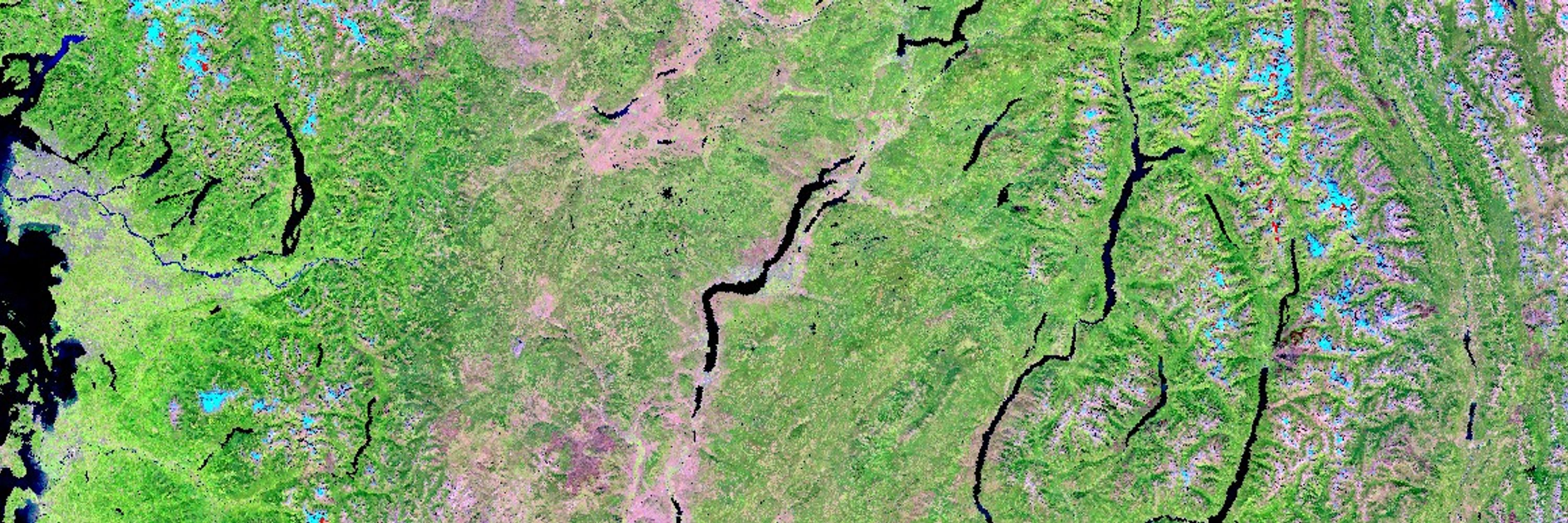
😍 Behold, Canada's 650 million hectare forest dominated ecosystems!
Mid-summer cloud free surface reflectance image composite made using Harmonized #Landsat #Sentinel2 (#HLS) data.
2024, 30m spatial resolution. #NTEMS
Mid-summer cloud free surface reflectance image composite made using Harmonized #Landsat #Sentinel2 (#HLS) data.
2024, 30m spatial resolution. #NTEMS

April 2, 2025 at 8:53 PM
😍 Behold, Canada's 650 million hectare forest dominated ecosystems!
Mid-summer cloud free surface reflectance image composite made using Harmonized #Landsat #Sentinel2 (#HLS) data.
2024, 30m spatial resolution. #NTEMS
Mid-summer cloud free surface reflectance image composite made using Harmonized #Landsat #Sentinel2 (#HLS) data.
2024, 30m spatial resolution. #NTEMS
Different wavelengths, different insights: Remote sensing inputs like land surface temp, soil moisture, and freeze/thaw each reveal unique constraints on boreal productivity—combining them improves estimates. #GPP
#SMAP #Landsat #HLS #Sentinel3 #SLSTR
Melser et al. (2025). doi.org/10.1016/j.ec...
#SMAP #Landsat #HLS #Sentinel3 #SLSTR
Melser et al. (2025). doi.org/10.1016/j.ec...

March 27, 2025 at 5:56 PM
Different wavelengths, different insights: Remote sensing inputs like land surface temp, soil moisture, and freeze/thaw each reveal unique constraints on boreal productivity—combining them improves estimates. #GPP
#SMAP #Landsat #HLS #Sentinel3 #SLSTR
Melser et al. (2025). doi.org/10.1016/j.ec...
#SMAP #Landsat #HLS #Sentinel3 #SLSTR
Melser et al. (2025). doi.org/10.1016/j.ec...
Check out this top #openaccess #review paper and give
@ramonmelser.bsky.social a follow!
➡️Melser et al. Multi-Source Remote Sensing Based Modeling of Vegetation Productivity in the Boreal: Issues & Opportunities.
#GPP #SMOS #SMAP #Landsat #Sentinel3 @irssubc.bsky.social
🔗 doi.org/10.1080/0703...
@ramonmelser.bsky.social a follow!
➡️Melser et al. Multi-Source Remote Sensing Based Modeling of Vegetation Productivity in the Boreal: Issues & Opportunities.
#GPP #SMOS #SMAP #Landsat #Sentinel3 @irssubc.bsky.social
🔗 doi.org/10.1080/0703...

March 20, 2025 at 8:54 PM
Check out this top #openaccess #review paper and give
@ramonmelser.bsky.social a follow!
➡️Melser et al. Multi-Source Remote Sensing Based Modeling of Vegetation Productivity in the Boreal: Issues & Opportunities.
#GPP #SMOS #SMAP #Landsat #Sentinel3 @irssubc.bsky.social
🔗 doi.org/10.1080/0703...
@ramonmelser.bsky.social a follow!
➡️Melser et al. Multi-Source Remote Sensing Based Modeling of Vegetation Productivity in the Boreal: Issues & Opportunities.
#GPP #SMOS #SMAP #Landsat #Sentinel3 @irssubc.bsky.social
🔗 doi.org/10.1080/0703...
Global 30m data, 1 to 3 day cadence w/ Landsat 8 & 9, Sentinel-2A & 2B. Maps frequency of good-quality obs.
Zhou et al. 2025. Toward Seamless Global 30-m Terrestrial Monitoring: Evaluating 2022 Cloud Free Coverage of Harmonized Landsat and Sentinel-2 (HLS) V2.0.
www.researchgate.net/publication/...
Zhou et al. 2025. Toward Seamless Global 30-m Terrestrial Monitoring: Evaluating 2022 Cloud Free Coverage of Harmonized Landsat and Sentinel-2 (HLS) V2.0.
www.researchgate.net/publication/...

March 10, 2025 at 9:52 PM
Global 30m data, 1 to 3 day cadence w/ Landsat 8 & 9, Sentinel-2A & 2B. Maps frequency of good-quality obs.
Zhou et al. 2025. Toward Seamless Global 30-m Terrestrial Monitoring: Evaluating 2022 Cloud Free Coverage of Harmonized Landsat and Sentinel-2 (HLS) V2.0.
www.researchgate.net/publication/...
Zhou et al. 2025. Toward Seamless Global 30-m Terrestrial Monitoring: Evaluating 2022 Cloud Free Coverage of Harmonized Landsat and Sentinel-2 (HLS) V2.0.
www.researchgate.net/publication/...
Thanks for your feedback. These types of map show land use. Land use permitted, not necessarily realized. Summarized nicely in the CCFM graphic below and found here: storymaps.arcgis.com/stories/52b7....
Government of Manitoba makes available tenure maps to check out as well.
Government of Manitoba makes available tenure maps to check out as well.

March 10, 2025 at 8:44 PM
Thanks for your feedback. These types of map show land use. Land use permitted, not necessarily realized. Summarized nicely in the CCFM graphic below and found here: storymaps.arcgis.com/stories/52b7....
Government of Manitoba makes available tenure maps to check out as well.
Government of Manitoba makes available tenure maps to check out as well.
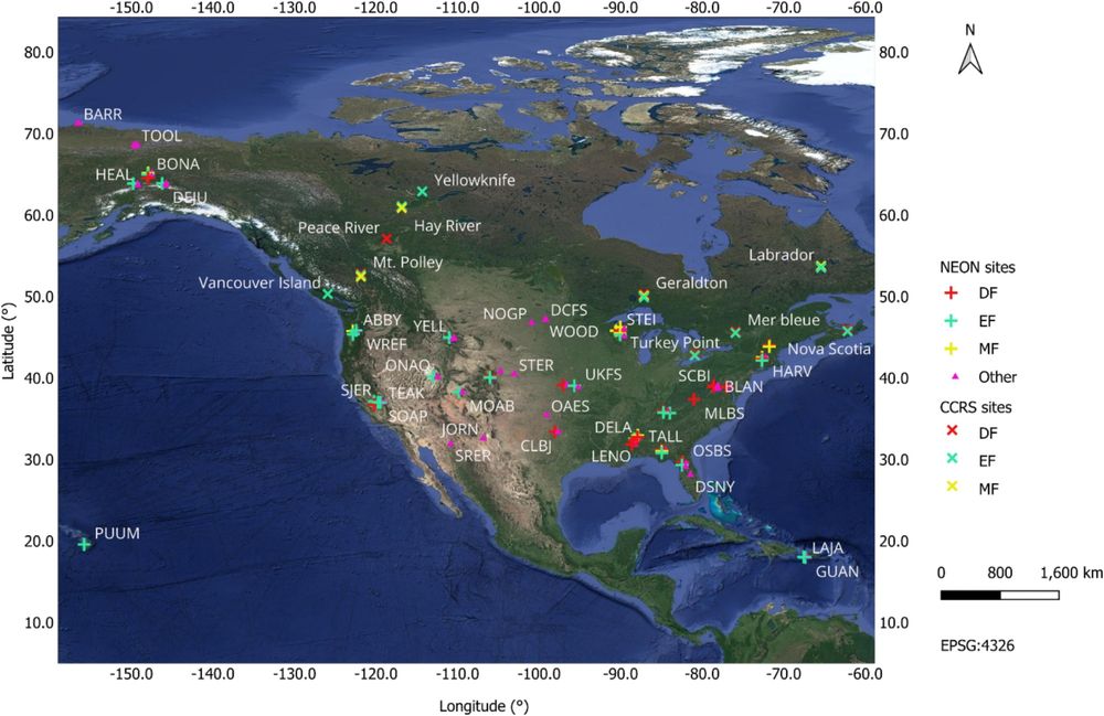
Total area of #lidar (ALS) coverage in Canada is 1,768,170 km2, or 19.4% of the total land area. Coverage of forested ecozones is ~27.2%, while coverage of managed forests is ~66.2%.
Up-to-date coverage stats: ptompalski.github.io/CanadaForest...
Paper: White et al. cdnsciencepub.com/doi/10.1139/...
Up-to-date coverage stats: ptompalski.github.io/CanadaForest...
Paper: White et al. cdnsciencepub.com/doi/10.1139/...

March 3, 2025 at 11:26 PM
Total area of #lidar (ALS) coverage in Canada is 1,768,170 km2, or 19.4% of the total land area. Coverage of forested ecozones is ~27.2%, while coverage of managed forests is ~66.2%.
Up-to-date coverage stats: ptompalski.github.io/CanadaForest...
Paper: White et al. cdnsciencepub.com/doi/10.1139/...
Up-to-date coverage stats: ptompalski.github.io/CanadaForest...
Paper: White et al. cdnsciencepub.com/doi/10.1139/...
🚨Context, review, insights and direction- paper has it all!
White et al. Enhanced forest inventories in Canada: implementation, status, and research needs.
🔗 cdnsciencepub.com/doi/10.1139/...
Plus, stay current with updated national #lidar coverage status maps:
ptompalski.github.io/CanadaForest...
White et al. Enhanced forest inventories in Canada: implementation, status, and research needs.
🔗 cdnsciencepub.com/doi/10.1139/...
Plus, stay current with updated national #lidar coverage status maps:
ptompalski.github.io/CanadaForest...

February 28, 2025 at 5:22 PM
🚨Context, review, insights and direction- paper has it all!
White et al. Enhanced forest inventories in Canada: implementation, status, and research needs.
🔗 cdnsciencepub.com/doi/10.1139/...
Plus, stay current with updated national #lidar coverage status maps:
ptompalski.github.io/CanadaForest...
White et al. Enhanced forest inventories in Canada: implementation, status, and research needs.
🔗 cdnsciencepub.com/doi/10.1139/...
Plus, stay current with updated national #lidar coverage status maps:
ptompalski.github.io/CanadaForest...
"Since 2000, glaciers have lost between 2% and 39% of their ice regionally and about 5% globally."
Zemp et al (The GlaMBIE Team). Community estimate of global glacier mass changes from 2000 to 2023.
🔗 www.nature.com/articles/s41...
Zemp et al (The GlaMBIE Team). Community estimate of global glacier mass changes from 2000 to 2023.
🔗 www.nature.com/articles/s41...

February 21, 2025 at 9:59 PM
"Since 2000, glaciers have lost between 2% and 39% of their ice regionally and about 5% globally."
Zemp et al (The GlaMBIE Team). Community estimate of global glacier mass changes from 2000 to 2023.
🔗 www.nature.com/articles/s41...
Zemp et al (The GlaMBIE Team). Community estimate of global glacier mass changes from 2000 to 2023.
🔗 www.nature.com/articles/s41...
📣Whorl detector extracts branching features of standing timber to predict internal wood quality.
➡️ Pehkonen et al. Identification and segmentation of branch whorls and sawlogs in standing timber using terrestrial laser scanning and deep learning. @forestryoup.bsky.social
🔗 doi.org/10.1093/fore...
➡️ Pehkonen et al. Identification and segmentation of branch whorls and sawlogs in standing timber using terrestrial laser scanning and deep learning. @forestryoup.bsky.social
🔗 doi.org/10.1093/fore...

February 18, 2025 at 7:27 PM
📣Whorl detector extracts branching features of standing timber to predict internal wood quality.
➡️ Pehkonen et al. Identification and segmentation of branch whorls and sawlogs in standing timber using terrestrial laser scanning and deep learning. @forestryoup.bsky.social
🔗 doi.org/10.1093/fore...
➡️ Pehkonen et al. Identification and segmentation of branch whorls and sawlogs in standing timber using terrestrial laser scanning and deep learning. @forestryoup.bsky.social
🔗 doi.org/10.1093/fore...
New: Parks et al. A fire deficit persists across diverse North American forests despite recent increases in area burned.
Data: tree-ring fire-scar network (NAFSN)
🔗 www.nature.com/articles/s41...
Figure illustrates the impacts of fire exclusion and suppression on area burned and fire severity:
Data: tree-ring fire-scar network (NAFSN)
🔗 www.nature.com/articles/s41...
Figure illustrates the impacts of fire exclusion and suppression on area burned and fire severity:

February 15, 2025 at 12:23 AM
New: Parks et al. A fire deficit persists across diverse North American forests despite recent increases in area burned.
Data: tree-ring fire-scar network (NAFSN)
🔗 www.nature.com/articles/s41...
Figure illustrates the impacts of fire exclusion and suppression on area burned and fire severity:
Data: tree-ring fire-scar network (NAFSN)
🔗 www.nature.com/articles/s41...
Figure illustrates the impacts of fire exclusion and suppression on area burned and fire severity: