


MetService NZ
@metservice.com
New Zealand's weather service. Helping Kiwi's be ready, whatever the weather.
⛈️A Severe Thunderstorm Warning has been issued for the Hurunui, Selwyn, Waimakariri and Christchurch City.
Details here bit.ly/STWarning
Details here bit.ly/STWarning

November 15, 2025 at 1:02 AM
⛈️A Severe Thunderstorm Warning has been issued for the Hurunui, Selwyn, Waimakariri and Christchurch City.
Details here bit.ly/STWarning
Details here bit.ly/STWarning
⛈️A Severe Thunderstorm Warning has been issued for the Timaru, Waimate area, South Island.
Details here
bit.ly/STWarning
Details here
bit.ly/STWarning

November 15, 2025 at 12:19 AM
⛈️A Severe Thunderstorm Warning has been issued for the Timaru, Waimate area, South Island.
Details here
bit.ly/STWarning
Details here
bit.ly/STWarning
🌧️A narrow front containing some heavy showers is moving slowly northeast across the North Island.
📡And spreading over Auckland as I type this heads-up!
View the radar images here
bit.ly/NZRainRadar
Your weather today
bit.ly/metservicenz
📡And spreading over Auckland as I type this heads-up!
View the radar images here
bit.ly/NZRainRadar
Your weather today
bit.ly/metservicenz

November 14, 2025 at 9:26 PM
🌧️A narrow front containing some heavy showers is moving slowly northeast across the North Island.
📡And spreading over Auckland as I type this heads-up!
View the radar images here
bit.ly/NZRainRadar
Your weather today
bit.ly/metservicenz
📡And spreading over Auckland as I type this heads-up!
View the radar images here
bit.ly/NZRainRadar
Your weather today
bit.ly/metservicenz
🌅Ata mārie, good morning Aotearoa New Zealand .
🌡️At 7am temperatures ranged from 5°C in Oamaru and Wanaka to 17°C up north in Tauranga and Whitianga.
Check your weekend forecast here
bit.ly/metservicenz
🌡️At 7am temperatures ranged from 5°C in Oamaru and Wanaka to 17°C up north in Tauranga and Whitianga.
Check your weekend forecast here
bit.ly/metservicenz

November 14, 2025 at 7:14 PM
🌅Ata mārie, good morning Aotearoa New Zealand .
🌡️At 7am temperatures ranged from 5°C in Oamaru and Wanaka to 17°C up north in Tauranga and Whitianga.
Check your weekend forecast here
bit.ly/metservicenz
🌡️At 7am temperatures ranged from 5°C in Oamaru and Wanaka to 17°C up north in Tauranga and Whitianga.
Check your weekend forecast here
bit.ly/metservicenz
Heads up eastern North Island⛈️
A Severe Thunderstorm Watch is in place this afternoon and evening🟡 Some thunderstorms may be severe, bringing:
💧Heavy downpours in localised areas
🧊Large hail
🚗Hazardous driving conditions
Full details can be found at www.metservice.com/warnings/home
A Severe Thunderstorm Watch is in place this afternoon and evening🟡 Some thunderstorms may be severe, bringing:
💧Heavy downpours in localised areas
🧊Large hail
🚗Hazardous driving conditions
Full details can be found at www.metservice.com/warnings/home

November 13, 2025 at 9:30 PM
Heads up eastern North Island⛈️
A Severe Thunderstorm Watch is in place this afternoon and evening🟡 Some thunderstorms may be severe, bringing:
💧Heavy downpours in localised areas
🧊Large hail
🚗Hazardous driving conditions
Full details can be found at www.metservice.com/warnings/home
A Severe Thunderstorm Watch is in place this afternoon and evening🟡 Some thunderstorms may be severe, bringing:
💧Heavy downpours in localised areas
🧊Large hail
🚗Hazardous driving conditions
Full details can be found at www.metservice.com/warnings/home
Mōrena all happy Friday! A much sunnier, drier and warmer day for Canterbury for the start of your long weekend. For the North Island, keep an eye on the radar today. Here's your Friday forecast, youtu.be/QytrM3Pbtek

NZ Weather Forecast - Friday 14th November 2025
YouTube video by MetService - NZ Weather
youtu.be
November 13, 2025 at 5:49 PM
Mōrena all happy Friday! A much sunnier, drier and warmer day for Canterbury for the start of your long weekend. For the North Island, keep an eye on the radar today. Here's your Friday forecast, youtu.be/QytrM3Pbtek
🔔Here’s your weather look from the sky🛰️📡
Showers persisting for the North Island; no lightning strike yet🌩, but the risk for thunderstorms remains for this afternoon and evening, downpours and hail also possible in places⛈🧊
Overcast with rain for the South Island🌧☔
Rain radar: bit.ly/NZRainRadar
Showers persisting for the North Island; no lightning strike yet🌩, but the risk for thunderstorms remains for this afternoon and evening, downpours and hail also possible in places⛈🧊
Overcast with rain for the South Island🌧☔
Rain radar: bit.ly/NZRainRadar

November 13, 2025 at 1:14 AM
🔔Here’s your weather look from the sky🛰️📡
Showers persisting for the North Island; no lightning strike yet🌩, but the risk for thunderstorms remains for this afternoon and evening, downpours and hail also possible in places⛈🧊
Overcast with rain for the South Island🌧☔
Rain radar: bit.ly/NZRainRadar
Showers persisting for the North Island; no lightning strike yet🌩, but the risk for thunderstorms remains for this afternoon and evening, downpours and hail also possible in places⛈🧊
Overcast with rain for the South Island🌧☔
Rain radar: bit.ly/NZRainRadar
⚠️Severe Weather Update
🟡💨There has been an update to the Strong Wind Watches affecting the North Island, the only affected areas now are Wellington and Wairarapa
North to northwest winds may approach severe gale with gust speeds reaching 90 km/h in exposed places🌬
For more: bit.ly/AllWarnings
🟡💨There has been an update to the Strong Wind Watches affecting the North Island, the only affected areas now are Wellington and Wairarapa
North to northwest winds may approach severe gale with gust speeds reaching 90 km/h in exposed places🌬
For more: bit.ly/AllWarnings

November 12, 2025 at 9:22 PM
⚠️Severe Weather Update
🟡💨There has been an update to the Strong Wind Watches affecting the North Island, the only affected areas now are Wellington and Wairarapa
North to northwest winds may approach severe gale with gust speeds reaching 90 km/h in exposed places🌬
For more: bit.ly/AllWarnings
🟡💨There has been an update to the Strong Wind Watches affecting the North Island, the only affected areas now are Wellington and Wairarapa
North to northwest winds may approach severe gale with gust speeds reaching 90 km/h in exposed places🌬
For more: bit.ly/AllWarnings
It’s a rainy day ahead New Zealand☔
That overnight rain persists through the day and is slowly moving south🌧️⬇
Don’t be surprised if you hear a rumble 🌩 in the north. Much of the North Island has a moderate risk for thunderstorms with bursts of heavier falls and localized downpours also possible⛈
That overnight rain persists through the day and is slowly moving south🌧️⬇
Don’t be surprised if you hear a rumble 🌩 in the north. Much of the North Island has a moderate risk for thunderstorms with bursts of heavier falls and localized downpours also possible⛈
November 12, 2025 at 7:09 PM
It’s a rainy day ahead New Zealand☔
That overnight rain persists through the day and is slowly moving south🌧️⬇
Don’t be surprised if you hear a rumble 🌩 in the north. Much of the North Island has a moderate risk for thunderstorms with bursts of heavier falls and localized downpours also possible⛈
That overnight rain persists through the day and is slowly moving south🌧️⬇
Don’t be surprised if you hear a rumble 🌩 in the north. Much of the North Island has a moderate risk for thunderstorms with bursts of heavier falls and localized downpours also possible⛈
🌦️Weather updates: Showers are building!
It's starting to get wet in the South Island, and it will be even wetter this afternoon and evening.
It's starting to get wet in the South Island, and it will be even wetter this afternoon and evening.
November 10, 2025 at 1:49 AM
🌦️Weather updates: Showers are building!
It's starting to get wet in the South Island, and it will be even wetter this afternoon and evening.
It's starting to get wet in the South Island, and it will be even wetter this afternoon and evening.
Keen for Cup Day? 🐴 Here's a visualisation of the weather Christchurch can expect on Tuesday.
Don't forget your sunscreen! 🌞
Don't forget your sunscreen! 🌞
November 10, 2025 at 12:35 AM
Keen for Cup Day? 🐴 Here's a visualisation of the weather Christchurch can expect on Tuesday.
Don't forget your sunscreen! 🌞
Don't forget your sunscreen! 🌞
We've got access to webcams around the country that help us monitor the weather. And sometimes we get visitors! 🐦⬛
With one pic every four minutes, it's not easy to catch birds in flight, but we got a lucky shot today 📸
With one pic every four minutes, it's not easy to catch birds in flight, but we got a lucky shot today 📸

November 9, 2025 at 9:19 PM
We've got access to webcams around the country that help us monitor the weather. And sometimes we get visitors! 🐦⬛
With one pic every four minutes, it's not easy to catch birds in flight, but we got a lucky shot today 📸
With one pic every four minutes, it's not easy to catch birds in flight, but we got a lucky shot today 📸
Mōrena, Aotearoa
We are expecting 🌡️summer weather, with max temps above 20°C in many areas. Napier should hit 29°C, nearly 10°C higher than the average November max. Hastings will be the warmest, hitting 31°C.
The West Coast of the South Island will stay cooler, with temps in the mid to high teens.
We are expecting 🌡️summer weather, with max temps above 20°C in many areas. Napier should hit 29°C, nearly 10°C higher than the average November max. Hastings will be the warmest, hitting 31°C.
The West Coast of the South Island will stay cooler, with temps in the mid to high teens.

November 9, 2025 at 7:16 PM
Mōrena, Aotearoa
We are expecting 🌡️summer weather, with max temps above 20°C in many areas. Napier should hit 29°C, nearly 10°C higher than the average November max. Hastings will be the warmest, hitting 31°C.
The West Coast of the South Island will stay cooler, with temps in the mid to high teens.
We are expecting 🌡️summer weather, with max temps above 20°C in many areas. Napier should hit 29°C, nearly 10°C higher than the average November max. Hastings will be the warmest, hitting 31°C.
The West Coast of the South Island will stay cooler, with temps in the mid to high teens.
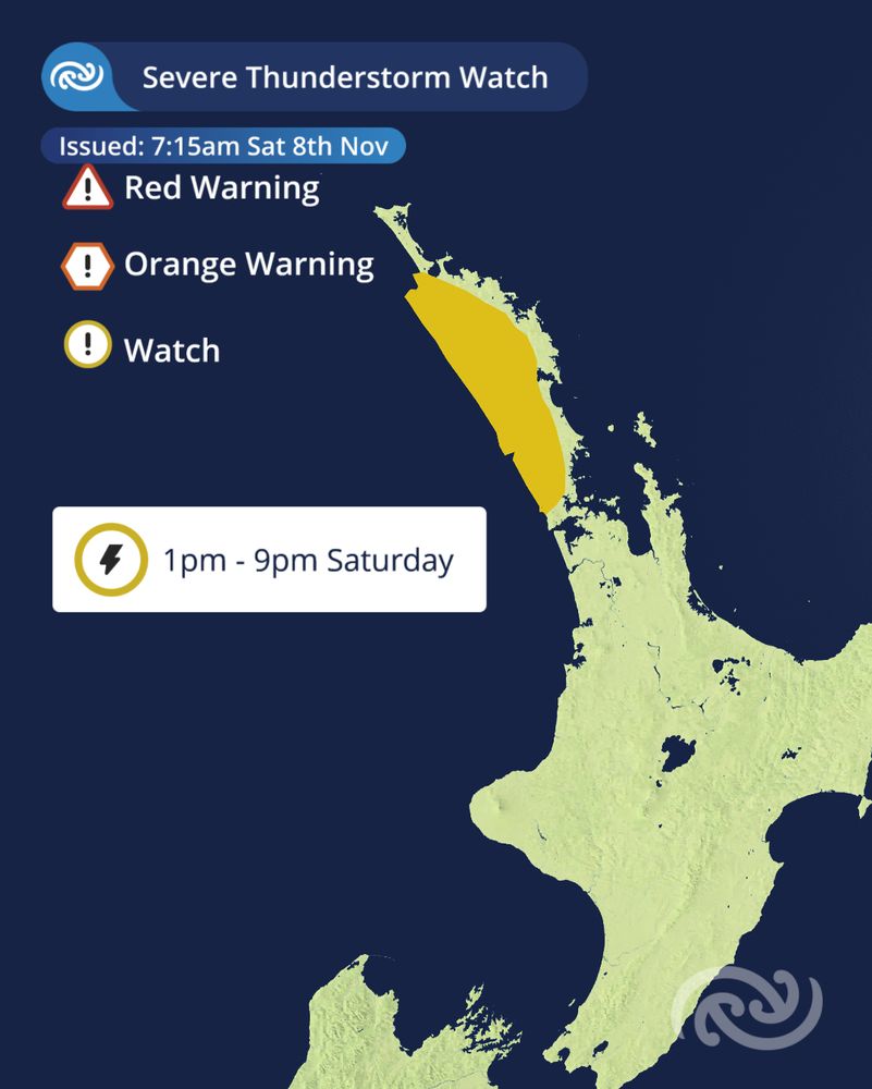
A Severe Thunderstorm Watch has been issued for parts of Northland and Auckland this afternoon and evening.
These storms can produce marble sized hail and flooding rainfall.
For more information: bit.ly/AllWarnings
These storms can produce marble sized hail and flooding rainfall.
For more information: bit.ly/AllWarnings
November 7, 2025 at 6:54 PM
A Severe Thunderstorm Watch has been issued for parts of Northland and Auckland this afternoon and evening.
These storms can produce marble sized hail and flooding rainfall.
For more information: bit.ly/AllWarnings
These storms can produce marble sized hail and flooding rainfall.
For more information: bit.ly/AllWarnings
Weather Outlook🔎🧐
A slow-moving front in the north is set to bring a burst of heavy rain tomorrow afternoon and evening🌧
Northland has a high chance for thunderstorms⚡, with localized downpours and hail 🌩💧🧊
In Auckland, the risk of thunderstorms is moderate⛈🌧🧊
Forecast: bit.ly/metservicenz
A slow-moving front in the north is set to bring a burst of heavy rain tomorrow afternoon and evening🌧
Northland has a high chance for thunderstorms⚡, with localized downpours and hail 🌩💧🧊
In Auckland, the risk of thunderstorms is moderate⛈🌧🧊
Forecast: bit.ly/metservicenz
November 7, 2025 at 1:51 AM
Weather Outlook🔎🧐
A slow-moving front in the north is set to bring a burst of heavy rain tomorrow afternoon and evening🌧
Northland has a high chance for thunderstorms⚡, with localized downpours and hail 🌩💧🧊
In Auckland, the risk of thunderstorms is moderate⛈🌧🧊
Forecast: bit.ly/metservicenz
A slow-moving front in the north is set to bring a burst of heavy rain tomorrow afternoon and evening🌧
Northland has a high chance for thunderstorms⚡, with localized downpours and hail 🌩💧🧊
In Auckland, the risk of thunderstorms is moderate⛈🌧🧊
Forecast: bit.ly/metservicenz
Midday Weather Update🛰️📡
🌧That rain in eastern areas of Northland spreads west this afternoon and evening, with the possibility of thunderstorms and short bursts of heavy rain⛈💧
Rain radar: bit.ly/NZRainRadar
🌧That rain in eastern areas of Northland spreads west this afternoon and evening, with the possibility of thunderstorms and short bursts of heavy rain⛈💧
Rain radar: bit.ly/NZRainRadar

November 7, 2025 at 12:27 AM
Midday Weather Update🛰️📡
🌧That rain in eastern areas of Northland spreads west this afternoon and evening, with the possibility of thunderstorms and short bursts of heavy rain⛈💧
Rain radar: bit.ly/NZRainRadar
🌧That rain in eastern areas of Northland spreads west this afternoon and evening, with the possibility of thunderstorms and short bursts of heavy rain⛈💧
Rain radar: bit.ly/NZRainRadar
⚠️Heads up Fiordland🔔
Although rain is expected in Fiordland for the next few days, it doesn’t approach warning criteria until Sunday evening when a front pushes in from the Tasman Sea.
🟡🌧A Heavy Rain Watch has been issued for Fiordland north of Doubtful Sound
For more: bit.ly/AllWarnings
Although rain is expected in Fiordland for the next few days, it doesn’t approach warning criteria until Sunday evening when a front pushes in from the Tasman Sea.
🟡🌧A Heavy Rain Watch has been issued for Fiordland north of Doubtful Sound
For more: bit.ly/AllWarnings

November 6, 2025 at 9:43 PM
⚠️Heads up Fiordland🔔
Although rain is expected in Fiordland for the next few days, it doesn’t approach warning criteria until Sunday evening when a front pushes in from the Tasman Sea.
🟡🌧A Heavy Rain Watch has been issued for Fiordland north of Doubtful Sound
For more: bit.ly/AllWarnings
Although rain is expected in Fiordland for the next few days, it doesn’t approach warning criteria until Sunday evening when a front pushes in from the Tasman Sea.
🟡🌧A Heavy Rain Watch has been issued for Fiordland north of Doubtful Sound
For more: bit.ly/AllWarnings
Good morning🌅
A front, over central New Zealand, has resulted in a cloudy start to the day with drizzle and showers☁🌧️
A wet day ahead for Northland as showers move in and persisting through the day☔
Some in the South Island woke up to high cloud🌤
Areas of fog still evident in some areas😶🌫️🌫️
A front, over central New Zealand, has resulted in a cloudy start to the day with drizzle and showers☁🌧️
A wet day ahead for Northland as showers move in and persisting through the day☔
Some in the South Island woke up to high cloud🌤
Areas of fog still evident in some areas😶🌫️🌫️

November 6, 2025 at 7:20 PM
Good morning🌅
A front, over central New Zealand, has resulted in a cloudy start to the day with drizzle and showers☁🌧️
A wet day ahead for Northland as showers move in and persisting through the day☔
Some in the South Island woke up to high cloud🌤
Areas of fog still evident in some areas😶🌫️🌫️
A front, over central New Zealand, has resulted in a cloudy start to the day with drizzle and showers☁🌧️
A wet day ahead for Northland as showers move in and persisting through the day☔
Some in the South Island woke up to high cloud🌤
Areas of fog still evident in some areas😶🌫️🌫️
Mōrena, Aotearoa 🌄
Temperatures are set to get summery today in parts of the motu, with Christchurch expected to reach 28°C (just over 8°C more than their average November max). Blenheim and Kaikōura won't be far behind with 27°C and 26°C respectively.
Temperatures are set to get summery today in parts of the motu, with Christchurch expected to reach 28°C (just over 8°C more than their average November max). Blenheim and Kaikōura won't be far behind with 27°C and 26°C respectively.

November 5, 2025 at 6:38 PM
Mōrena, Aotearoa 🌄
Temperatures are set to get summery today in parts of the motu, with Christchurch expected to reach 28°C (just over 8°C more than their average November max). Blenheim and Kaikōura won't be far behind with 27°C and 26°C respectively.
Temperatures are set to get summery today in parts of the motu, with Christchurch expected to reach 28°C (just over 8°C more than their average November max). Blenheim and Kaikōura won't be far behind with 27°C and 26°C respectively.
Invercargill has overtaken Auckland on temperature today! 🥵🌡️
As on 3:30pm, Invercargill observed 23.8°C (currently 8°C above average) meanwhile Auckland was only at 22.2°C!
Latest temperature forecasts here: metservice.com
As on 3:30pm, Invercargill observed 23.8°C (currently 8°C above average) meanwhile Auckland was only at 22.2°C!
Latest temperature forecasts here: metservice.com

November 5, 2025 at 2:39 AM
Invercargill has overtaken Auckland on temperature today! 🥵🌡️
As on 3:30pm, Invercargill observed 23.8°C (currently 8°C above average) meanwhile Auckland was only at 22.2°C!
Latest temperature forecasts here: metservice.com
As on 3:30pm, Invercargill observed 23.8°C (currently 8°C above average) meanwhile Auckland was only at 22.2°C!
Latest temperature forecasts here: metservice.com
Heather Keates has a special Guy Fawke’s Forecast for you today 🎇 ↓
It’s warm and dry and in some places windy, so if you are lighting fireworks, please check the weather forecast before sending any off. It’s not recommended to light fireworks if it is windy 💨
It’s warm and dry and in some places windy, so if you are lighting fireworks, please check the weather forecast before sending any off. It’s not recommended to light fireworks if it is windy 💨
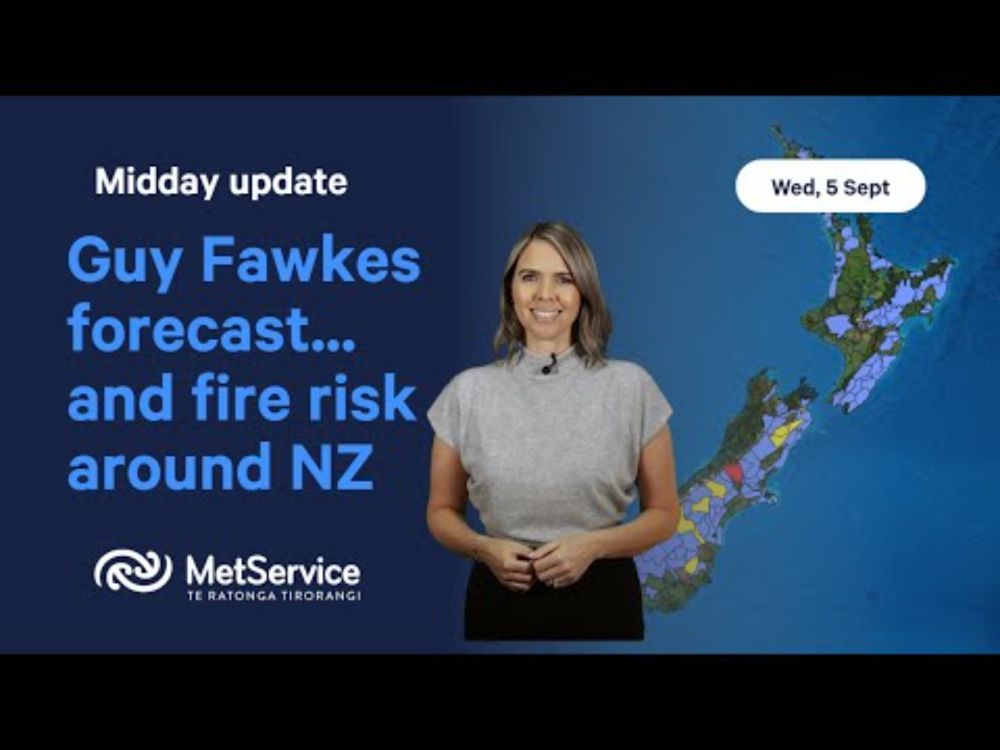
Guy Fawke's Forecast - Wednesday 5th November 2025
YouTube video by MetService - NZ Weather
www.youtube.com
November 5, 2025 at 12:58 AM
Heather Keates has a special Guy Fawke’s Forecast for you today 🎇 ↓
It’s warm and dry and in some places windy, so if you are lighting fireworks, please check the weather forecast before sending any off. It’s not recommended to light fireworks if it is windy 💨
It’s warm and dry and in some places windy, so if you are lighting fireworks, please check the weather forecast before sending any off. It’s not recommended to light fireworks if it is windy 💨
🌡️How are our temperatures doing?
🌡️Forecast Maximums for Today:
Auckland – 23
Tauranga – 23
Taupo – 22
Wellington – 18
Blenheim – 24
Christchurch – 18
Queenstown – 22
More information: metservice.com
🌡️Forecast Maximums for Today:
Auckland – 23
Tauranga – 23
Taupo – 22
Wellington – 18
Blenheim – 24
Christchurch – 18
Queenstown – 22
More information: metservice.com

November 4, 2025 at 11:13 PM
🌡️How are our temperatures doing?
🌡️Forecast Maximums for Today:
Auckland – 23
Tauranga – 23
Taupo – 22
Wellington – 18
Blenheim – 24
Christchurch – 18
Queenstown – 22
More information: metservice.com
🌡️Forecast Maximums for Today:
Auckland – 23
Tauranga – 23
Taupo – 22
Wellington – 18
Blenheim – 24
Christchurch – 18
Queenstown – 22
More information: metservice.com
☀️Good morning! It’s going to be a sunny and dry day for many after some morning cloud lifts.
🌡️Highs of 23°C expected for Auckland, which is 4°C above average!
☁️ 💨🌧️ It's cloudier in Fiordland though, with rain from late afternoon.
Find our latest forecasts here: metservice.com
🌡️Highs of 23°C expected for Auckland, which is 4°C above average!
☁️ 💨🌧️ It's cloudier in Fiordland though, with rain from late afternoon.
Find our latest forecasts here: metservice.com

November 4, 2025 at 7:12 PM
☀️Good morning! It’s going to be a sunny and dry day for many after some morning cloud lifts.
🌡️Highs of 23°C expected for Auckland, which is 4°C above average!
☁️ 💨🌧️ It's cloudier in Fiordland though, with rain from late afternoon.
Find our latest forecasts here: metservice.com
🌡️Highs of 23°C expected for Auckland, which is 4°C above average!
☁️ 💨🌧️ It's cloudier in Fiordland though, with rain from late afternoon.
Find our latest forecasts here: metservice.com
🌅Ata mārie, good morning Aotearoa New Zealand.
🚴♂️It was a bright and breezy bike to work this morning in Wellington!
What's the weather up to?
🔗http://bit.ly/metservicenz
🚴♂️It was a bright and breezy bike to work this morning in Wellington!
What's the weather up to?
🔗http://bit.ly/metservicenz

November 3, 2025 at 7:16 PM
🌅Ata mārie, good morning Aotearoa New Zealand.
🚴♂️It was a bright and breezy bike to work this morning in Wellington!
What's the weather up to?
🔗http://bit.ly/metservicenz
🚴♂️It was a bright and breezy bike to work this morning in Wellington!
What's the weather up to?
🔗http://bit.ly/metservicenz
The sunshine has come out for Marlborough Anniversary Day today (Monday) and there are plenty of blue skies across the rest of the country. ☀🌡
Invercargill looks to rise to 24°C on Wednesday. Christchurch and Hastings are set to get to 27°C on Thursday.
Invercargill looks to rise to 24°C on Wednesday. Christchurch and Hastings are set to get to 27°C on Thursday.
November 3, 2025 at 12:51 AM
The sunshine has come out for Marlborough Anniversary Day today (Monday) and there are plenty of blue skies across the rest of the country. ☀🌡
Invercargill looks to rise to 24°C on Wednesday. Christchurch and Hastings are set to get to 27°C on Thursday.
Invercargill looks to rise to 24°C on Wednesday. Christchurch and Hastings are set to get to 27°C on Thursday.