


Map Myths
@mapmyths.com
Map Myths delves into the stories and people behind the phantom geography found on maps - by @rhewlif.xyz
Myth map 👉 https://mapmyths.com
Long reads 👉 https://mapmyths.com/blog
Myth map 👉 https://mapmyths.com
Long reads 👉 https://mapmyths.com/blog
Even though Burdwood Island was a phantom, it would go on to give its name to Burdwood Bank, a seafloor prominence around 200 km south of the Falkland Islands.

November 14, 2025 at 9:49 PM
Even though Burdwood Island was a phantom, it would go on to give its name to Burdwood Bank, a seafloor prominence around 200 km south of the Falkland Islands.
The Spanish had also reported such a rock at the same location 15 years earlier. However, these 'sightings' were likely a mirage (fata morgana) of Beauchene Island, the southernmost of the Falkland Islands, which had been discovered over a century earlier.

November 14, 2025 at 9:49 PM
The Spanish had also reported such a rock at the same location 15 years earlier. However, these 'sightings' were likely a mirage (fata morgana) of Beauchene Island, the southernmost of the Falkland Islands, which had been discovered over a century earlier.
Enchuyser would go on to appear on several Dutch maps during the 17th century. But by the 18th century, its status had been downgraded to doubtful.
Possible candidates for Enchuyser include the sandbars Hvalbakur or Færabakur, both of which lie significantly closer to the Icelandic coast.
Possible candidates for Enchuyser include the sandbars Hvalbakur or Færabakur, both of which lie significantly closer to the Icelandic coast.

November 6, 2025 at 10:01 PM
Enchuyser would go on to appear on several Dutch maps during the 17th century. But by the 18th century, its status had been downgraded to doubtful.
Possible candidates for Enchuyser include the sandbars Hvalbakur or Færabakur, both of which lie significantly closer to the Icelandic coast.
Possible candidates for Enchuyser include the sandbars Hvalbakur or Færabakur, both of which lie significantly closer to the Icelandic coast.
Though 'New Holland' was likely a sighting of the east coast of Greenland, Carolus included Opdams Island on his 1634 chart, renaming it Enchuyser.
The name change was apparently an homage to Carolus' hometown of Enkhuizen.
The name change was apparently an homage to Carolus' hometown of Enkhuizen.

November 6, 2025 at 10:01 PM
Though 'New Holland' was likely a sighting of the east coast of Greenland, Carolus included Opdams Island on his 1634 chart, renaming it Enchuyser.
The name change was apparently an homage to Carolus' hometown of Enkhuizen.
The name change was apparently an homage to Carolus' hometown of Enkhuizen.
In 1617, Joris Carolus was commissioned by the Noordsche Compagnie - a Dutch whaling cartel - to lead a voyage of discovery.
The mission was apparently successful, with the discovery of two new islands. The first he named Nyeu Hollandt, while the other he named Opdams Eylandt.
The mission was apparently successful, with the discovery of two new islands. The first he named Nyeu Hollandt, while the other he named Opdams Eylandt.

November 6, 2025 at 10:01 PM
In 1617, Joris Carolus was commissioned by the Noordsche Compagnie - a Dutch whaling cartel - to lead a voyage of discovery.
The mission was apparently successful, with the discovery of two new islands. The first he named Nyeu Hollandt, while the other he named Opdams Eylandt.
The mission was apparently successful, with the discovery of two new islands. The first he named Nyeu Hollandt, while the other he named Opdams Eylandt.
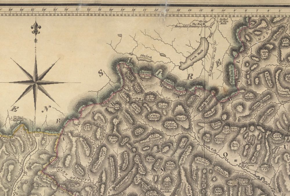
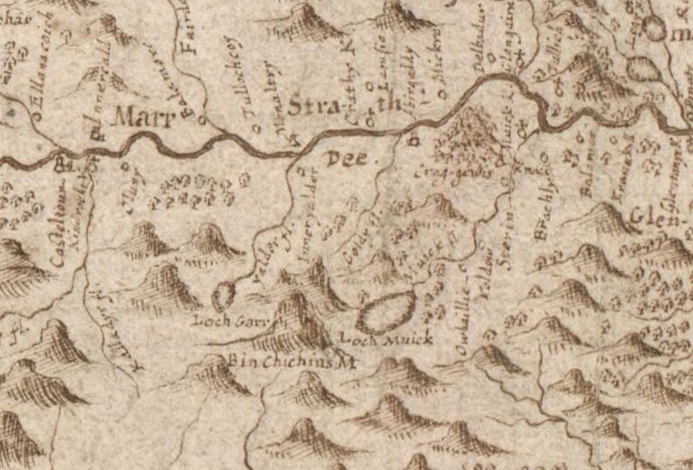
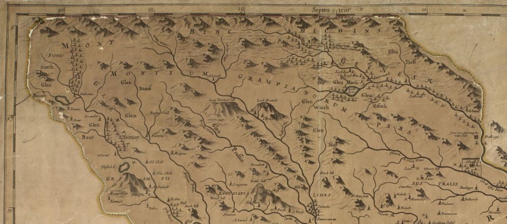
This notion was solidified when, in 1678, Robert Edward wrote that the 'very lofty mountains of Binchichins' as formed '...the boundary between Angus and Aberdeenshire, for the space of nineteen [Scotch] miles'.
(Two Scotch miles are the equivalent of three English miles)
(Two Scotch miles are the equivalent of three English miles)
October 24, 2025 at 8:39 AM
This notion was solidified when, in 1678, Robert Edward wrote that the 'very lofty mountains of Binchichins' as formed '...the boundary between Angus and Aberdeenshire, for the space of nineteen [Scotch] miles'.
(Two Scotch miles are the equivalent of three English miles)
(Two Scotch miles are the equivalent of three English miles)
On the first detailed maps of the Grampian Mountains made by Robert Gordon, the mountain appears annotated correctly, south of Loch Garr.
But over time, and apparent unfamiliarity with the hill in question, cartographers began to extend the 'Benchichins' out into its own mountain range.
But over time, and apparent unfamiliarity with the hill in question, cartographers began to extend the 'Benchichins' out into its own mountain range.
October 24, 2025 at 8:39 AM
On the first detailed maps of the Grampian Mountains made by Robert Gordon, the mountain appears annotated correctly, south of Loch Garr.
But over time, and apparent unfamiliarity with the hill in question, cartographers began to extend the 'Benchichins' out into its own mountain range.
But over time, and apparent unfamiliarity with the hill in question, cartographers began to extend the 'Benchichins' out into its own mountain range.
The 'Binchichins' is a story of how one Scottish mountain became an entire mountain range, before disappearing from maps entirely.
During the early 17th century, the original Gaelic name used for the mountain recognised today as Lochnagar was Beinn nan Chìochan (the hill of the paps/breasts).
During the early 17th century, the original Gaelic name used for the mountain recognised today as Lochnagar was Beinn nan Chìochan (the hill of the paps/breasts).

October 24, 2025 at 8:39 AM
The 'Binchichins' is a story of how one Scottish mountain became an entire mountain range, before disappearing from maps entirely.
During the early 17th century, the original Gaelic name used for the mountain recognised today as Lochnagar was Beinn nan Chìochan (the hill of the paps/breasts).
During the early 17th century, the original Gaelic name used for the mountain recognised today as Lochnagar was Beinn nan Chìochan (the hill of the paps/breasts).
But did they go on to discover America, some 2 decades before Columbus?
According to a theory pieced together in 1925, inscriptions and suprisingly accurate coastlines of Novia Scotia found on contemporary globes indicate knowledge of the New World already existed before Columbus sailed in 1492.
According to a theory pieced together in 1925, inscriptions and suprisingly accurate coastlines of Novia Scotia found on contemporary globes indicate knowledge of the New World already existed before Columbus sailed in 1492.


October 19, 2025 at 1:28 PM
But did they go on to discover America, some 2 decades before Columbus?
According to a theory pieced together in 1925, inscriptions and suprisingly accurate coastlines of Novia Scotia found on contemporary globes indicate knowledge of the New World already existed before Columbus sailed in 1492.
According to a theory pieced together in 1925, inscriptions and suprisingly accurate coastlines of Novia Scotia found on contemporary globes indicate knowledge of the New World already existed before Columbus sailed in 1492.
Historic maps alude to Didrik Pining and Hans Pothorst reaching the Greenland-Icelandic frontier, where they erected a sea-mark on the high cliffs of Hvitsarc.


October 19, 2025 at 1:28 PM
Historic maps alude to Didrik Pining and Hans Pothorst reaching the Greenland-Icelandic frontier, where they erected a sea-mark on the high cliffs of Hvitsarc.
📣 NEW BLOG POST
Did German pirates beat Columbus to America?
Sometime in the 1470s, King Christian I of Denmark hired two German privateers "at the request of his majesty of Portugal...to explore new countries and islands in the north".
Did German pirates beat Columbus to America?
Sometime in the 1470s, King Christian I of Denmark hired two German privateers "at the request of his majesty of Portugal...to explore new countries and islands in the north".

October 19, 2025 at 1:28 PM
📣 NEW BLOG POST
Did German pirates beat Columbus to America?
Sometime in the 1470s, King Christian I of Denmark hired two German privateers "at the request of his majesty of Portugal...to explore new countries and islands in the north".
Did German pirates beat Columbus to America?
Sometime in the 1470s, King Christian I of Denmark hired two German privateers "at the request of his majesty of Portugal...to explore new countries and islands in the north".
The map was part of Engelbert Kaempfer's collection, a German naturalist whose works 'introduced Japan to the West', before his death in 1716.
Perhaps it was Kaempfer's kitty craving some attention during a long writing session.
Perhaps it was Kaempfer's kitty craving some attention during a long writing session.


October 13, 2025 at 4:05 PM
The map was part of Engelbert Kaempfer's collection, a German naturalist whose works 'introduced Japan to the West', before his death in 1716.
Perhaps it was Kaempfer's kitty craving some attention during a long writing session.
Perhaps it was Kaempfer's kitty craving some attention during a long writing session.
No map is safe from a cat's curiosity!
Ultraviolet photography of this 17th-century Japanese map of Nagasaki has revealed the unsuspected paw prints of a cat.
Ultraviolet photography of this 17th-century Japanese map of Nagasaki has revealed the unsuspected paw prints of a cat.
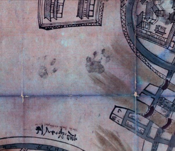
![Map: Nagasaki ezu [長崎絵図], 1680-1688. A large-scale pictorial map of the port of Nagasaki, hand-coloured, with sketches of Dutch and Chinese ships, showing also the island of Deshima. Panels at bottom left show Chinese, Dutch and other foreigners in costume, and two tables giving distances in ri of foreign ports from Japan and details of the town of Nagasaki. Source: British Library](https://cdn.bsky.app/img/feed_thumbnail/plain/did:plc:gohbwk2wlwrjiqejxg3femmz/bafkreicguuhkpniw73yb2mqgtlbjozr77xqftpilgcwfymfs6w2rm6qdxu@jpeg)
October 13, 2025 at 4:05 PM
No map is safe from a cat's curiosity!
Ultraviolet photography of this 17th-century Japanese map of Nagasaki has revealed the unsuspected paw prints of a cat.
Ultraviolet photography of this 17th-century Japanese map of Nagasaki has revealed the unsuspected paw prints of a cat.
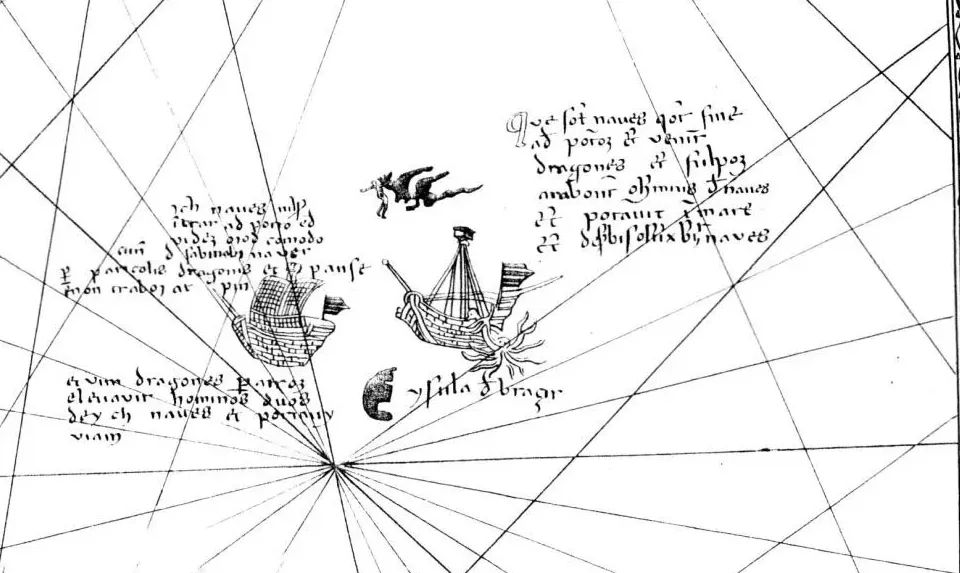
For Olaus and his contemporaries, the sea was not an empty void but a living, dangerous, and mysterious domain. The Age of Discovery was just beginning, and many of the animals depicted were considered to be real, albeit poorly understood, creatures.


September 29, 2025 at 4:17 PM
For Olaus and his contemporaries, the sea was not an empty void but a living, dangerous, and mysterious domain. The Age of Discovery was just beginning, and many of the animals depicted were considered to be real, albeit poorly understood, creatures.
📣 NEW BLOG POST
In the sixteenth century, enormous man-eating monsters ruled the oceans. Nowhere else are these fear-inducing creatures better depicted than on the 1539 "Carta Marina" by Olaus Magnus.
In the sixteenth century, enormous man-eating monsters ruled the oceans. Nowhere else are these fear-inducing creatures better depicted than on the 1539 "Carta Marina" by Olaus Magnus.

September 29, 2025 at 4:17 PM
📣 NEW BLOG POST
In the sixteenth century, enormous man-eating monsters ruled the oceans. Nowhere else are these fear-inducing creatures better depicted than on the 1539 "Carta Marina" by Olaus Magnus.
In the sixteenth century, enormous man-eating monsters ruled the oceans. Nowhere else are these fear-inducing creatures better depicted than on the 1539 "Carta Marina" by Olaus Magnus.
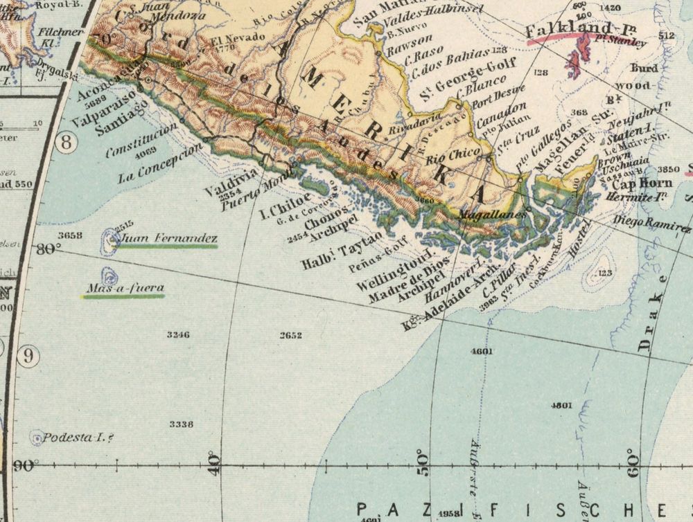
The US Hydrographic Office list of 1891 had already marked Podesta Island as 'probably non-existent' after several ships had failed to find it again.
Yet the island still persisted on charts through the 20th century, and remarkably still remains on Google Maps with a not too undecent rating of 3.8.
Yet the island still persisted on charts through the 20th century, and remarkably still remains on Google Maps with a not too undecent rating of 3.8.

September 23, 2025 at 3:20 PM
The US Hydrographic Office list of 1891 had already marked Podesta Island as 'probably non-existent' after several ships had failed to find it again.
Yet the island still persisted on charts through the 20th century, and remarkably still remains on Google Maps with a not too undecent rating of 3.8.
Yet the island still persisted on charts through the 20th century, and remarkably still remains on Google Maps with a not too undecent rating of 3.8.
Like a flat-earth conspiracy theory, Podesta is one phantom island that has refused to die, and has even recently been 'annexed'.
Discovered by the aptly named Captain Pinocchio* in 1879 off the coast of Chile, it was supposedly 1 km in circumference.
*Finocchio, according to some sources
Discovered by the aptly named Captain Pinocchio* in 1879 off the coast of Chile, it was supposedly 1 km in circumference.
*Finocchio, according to some sources

September 23, 2025 at 3:20 PM
Like a flat-earth conspiracy theory, Podesta is one phantom island that has refused to die, and has even recently been 'annexed'.
Discovered by the aptly named Captain Pinocchio* in 1879 off the coast of Chile, it was supposedly 1 km in circumference.
*Finocchio, according to some sources
Discovered by the aptly named Captain Pinocchio* in 1879 off the coast of Chile, it was supposedly 1 km in circumference.
*Finocchio, according to some sources
A further search for the island in 1909 by Shackleton's Nimrod, and Amundsen in 1910, also turned up nothing, suggesting the original sighting was likely a mistaken iceberg.
The abyssal plain on the ocean floor beneath the location of this phantom island is now named Emerald Basin.
The abyssal plain on the ocean floor beneath the location of this phantom island is now named Emerald Basin.

September 12, 2025 at 12:06 PM
A further search for the island in 1909 by Shackleton's Nimrod, and Amundsen in 1910, also turned up nothing, suggesting the original sighting was likely a mistaken iceberg.
The abyssal plain on the ocean floor beneath the location of this phantom island is now named Emerald Basin.
The abyssal plain on the ocean floor beneath the location of this phantom island is now named Emerald Basin.
Lt Wilkes of the US Exploring Expedition of 1838-42 later attempted to use Emerald Island as a rendezvous point for his fleet during its approach to Antarctica, without success.

September 12, 2025 at 12:06 PM
Lt Wilkes of the US Exploring Expedition of 1838-42 later attempted to use Emerald Island as a rendezvous point for his fleet during its approach to Antarctica, without success.
The 'semblance' of an island, thirty miles long with high peaked mountains, was sighted by C.J. Nockells of the British sealing ship Emerald, in December 1821.

September 12, 2025 at 12:06 PM
The 'semblance' of an island, thirty miles long with high peaked mountains, was sighted by C.J. Nockells of the British sealing ship Emerald, in December 1821.
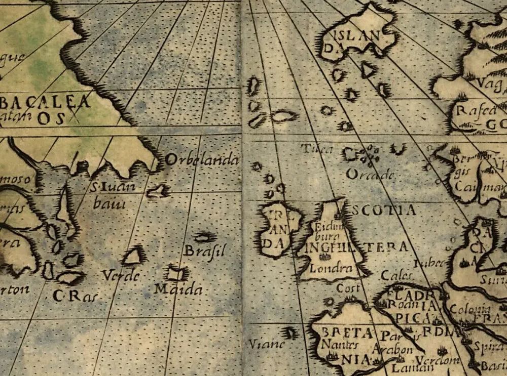
Was it really a mythological land though? In 1948, a 45 km-wide point of land at coordinates of 46°23′N 37°20′W was found submerged only 36.5 m below the ocean surface. Significantly, this location due west of Brittany tallies with the earliest map drawings.
📖 mapmyths.com#mayda
📖 mapmyths.com#mayda

September 1, 2025 at 1:51 PM
Was it really a mythological land though? In 1948, a 45 km-wide point of land at coordinates of 46°23′N 37°20′W was found submerged only 36.5 m below the ocean surface. Significantly, this location due west of Brittany tallies with the earliest map drawings.
📖 mapmyths.com#mayda
📖 mapmyths.com#mayda
Despite its popularity with cartographers for over five centuries, no accounts exist of anyone having visited its shores.
Some have speculated Mayda could have been a very early depiction of Corvo in the Azores, or even the crescent-shaped lands of Bermuda, Cape Cod or Cape Breton in the Americas.
Some have speculated Mayda could have been a very early depiction of Corvo in the Azores, or even the crescent-shaped lands of Bermuda, Cape Cod or Cape Breton in the Americas.

September 1, 2025 at 1:51 PM
Despite its popularity with cartographers for over five centuries, no accounts exist of anyone having visited its shores.
Some have speculated Mayda could have been a very early depiction of Corvo in the Azores, or even the crescent-shaped lands of Bermuda, Cape Cod or Cape Breton in the Americas.
Some have speculated Mayda could have been a very early depiction of Corvo in the Azores, or even the crescent-shaped lands of Bermuda, Cape Cod or Cape Breton in the Americas.
Mayda, with its many pseudonyms, is one of the most enduring phantom islands of the North Atlantic, though its origin is largely unknown.
Its signature crescent shape first appears in 1367 with the label Brazir, with the more common name of Mayda appearing only later in 1553.
Its signature crescent shape first appears in 1367 with the label Brazir, with the more common name of Mayda appearing only later in 1553.

September 1, 2025 at 1:51 PM
Mayda, with its many pseudonyms, is one of the most enduring phantom islands of the North Atlantic, though its origin is largely unknown.
Its signature crescent shape first appears in 1367 with the label Brazir, with the more common name of Mayda appearing only later in 1553.
Its signature crescent shape first appears in 1367 with the label Brazir, with the more common name of Mayda appearing only later in 1553.
Charting mistakes along this coastline were likely due to the abundance of shallow coral reefs here preventing access to deep ocean-going vessels.
The duplication of the major island of Bahrain as Samak (translated to fish) can be traced to an early alternative name that was used for this island.
The duplication of the major island of Bahrain as Samak (translated to fish) can be traced to an early alternative name that was used for this island.

August 17, 2025 at 7:12 PM
Charting mistakes along this coastline were likely due to the abundance of shallow coral reefs here preventing access to deep ocean-going vessels.
The duplication of the major island of Bahrain as Samak (translated to fish) can be traced to an early alternative name that was used for this island.
The duplication of the major island of Bahrain as Samak (translated to fish) can be traced to an early alternative name that was used for this island.
Although the peninsula had been included on some maps from two centuries earlier, this particular error (perpetuated mostly on French maps) appears to have stemmed from an influential chart of the Persian Gulf prepared by Jean Baptiste Nicolas Denis d'Apres de Mannevillette in 1745.

August 17, 2025 at 7:12 PM
Although the peninsula had been included on some maps from two centuries earlier, this particular error (perpetuated mostly on French maps) appears to have stemmed from an influential chart of the Persian Gulf prepared by Jean Baptiste Nicolas Denis d'Apres de Mannevillette in 1745.