


Map Myths
@mapmyths.com
Map Myths delves into the stories and people behind the phantom geography found on maps - by @rhewlif.xyz
Myth map 👉 https://mapmyths.com
Long reads 👉 https://mapmyths.com/blog
Myth map 👉 https://mapmyths.com
Long reads 👉 https://mapmyths.com/blog
Enchuyser would go on to appear on several Dutch maps during the 17th century. But by the 18th century, its status had been downgraded to doubtful.
Possible candidates for Enchuyser include the sandbars Hvalbakur or Færabakur, both of which lie significantly closer to the Icelandic coast.
Possible candidates for Enchuyser include the sandbars Hvalbakur or Færabakur, both of which lie significantly closer to the Icelandic coast.

November 6, 2025 at 10:01 PM
Enchuyser would go on to appear on several Dutch maps during the 17th century. But by the 18th century, its status had been downgraded to doubtful.
Possible candidates for Enchuyser include the sandbars Hvalbakur or Færabakur, both of which lie significantly closer to the Icelandic coast.
Possible candidates for Enchuyser include the sandbars Hvalbakur or Færabakur, both of which lie significantly closer to the Icelandic coast.
Though 'New Holland' was likely a sighting of the east coast of Greenland, Carolus included Opdams Island on his 1634 chart, renaming it Enchuyser.
The name change was apparently an homage to Carolus' hometown of Enkhuizen.
The name change was apparently an homage to Carolus' hometown of Enkhuizen.

November 6, 2025 at 10:01 PM
Though 'New Holland' was likely a sighting of the east coast of Greenland, Carolus included Opdams Island on his 1634 chart, renaming it Enchuyser.
The name change was apparently an homage to Carolus' hometown of Enkhuizen.
The name change was apparently an homage to Carolus' hometown of Enkhuizen.
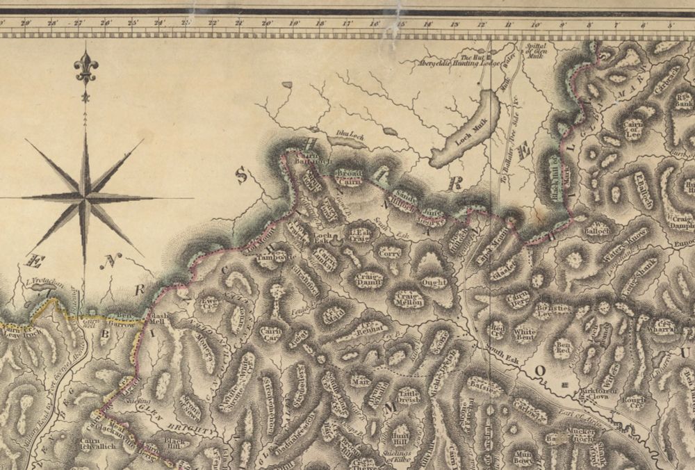
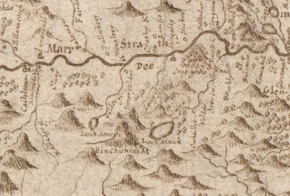
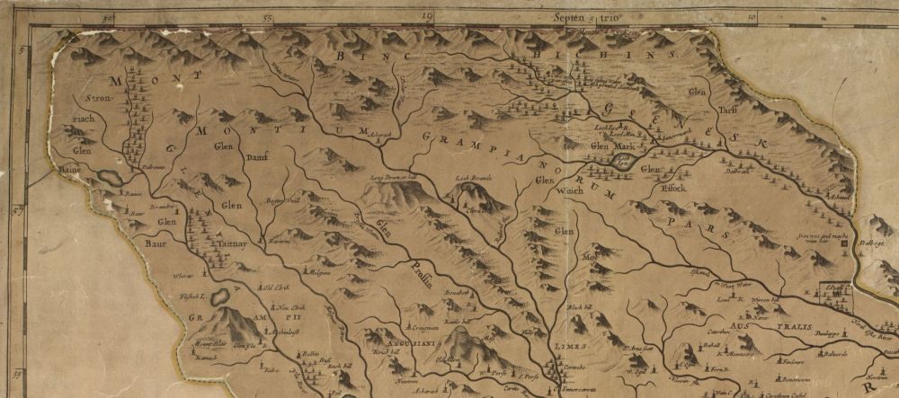
The mountain range of Binchichins continued to persist on maps through to the mid-19th century, until more accurate surveys were carried out and the name of Binchichin disappeared entirely.
📖 mapmyths.com#binchichins
📖 mapmyths.com#binchichins
October 24, 2025 at 8:39 AM
The mountain range of Binchichins continued to persist on maps through to the mid-19th century, until more accurate surveys were carried out and the name of Binchichin disappeared entirely.
📖 mapmyths.com#binchichins
📖 mapmyths.com#binchichins
And so the mountain formerly known as Beinn nan Chìochan began to adopt the name of the loch below, made famous by the 1807 poem 'Dark Lochnagar' by Lord Byron.

The Corries Lochnagar
YouTube video by Iain40
youtu.be
October 24, 2025 at 8:39 AM
And so the mountain formerly known as Beinn nan Chìochan began to adopt the name of the loch below, made famous by the 1807 poem 'Dark Lochnagar' by Lord Byron.
This notion was solidified when, in 1678, Robert Edward wrote that the 'very lofty mountains of Binchichins' as formed '...the boundary between Angus and Aberdeenshire, for the space of nineteen [Scotch] miles'.
(Two Scotch miles are the equivalent of three English miles)
(Two Scotch miles are the equivalent of three English miles)
October 24, 2025 at 8:39 AM
This notion was solidified when, in 1678, Robert Edward wrote that the 'very lofty mountains of Binchichins' as formed '...the boundary between Angus and Aberdeenshire, for the space of nineteen [Scotch] miles'.
(Two Scotch miles are the equivalent of three English miles)
(Two Scotch miles are the equivalent of three English miles)
On the first detailed maps of the Grampian Mountains made by Robert Gordon, the mountain appears annotated correctly, south of Loch Garr.
But over time, and apparent unfamiliarity with the hill in question, cartographers began to extend the 'Benchichins' out into its own mountain range.
But over time, and apparent unfamiliarity with the hill in question, cartographers began to extend the 'Benchichins' out into its own mountain range.
October 24, 2025 at 8:39 AM
On the first detailed maps of the Grampian Mountains made by Robert Gordon, the mountain appears annotated correctly, south of Loch Garr.
But over time, and apparent unfamiliarity with the hill in question, cartographers began to extend the 'Benchichins' out into its own mountain range.
But over time, and apparent unfamiliarity with the hill in question, cartographers began to extend the 'Benchichins' out into its own mountain range.
Today this mysterious voyage is celebrated on a wood carving on the Glockenspiel House in Bremen, Germany.
Although there is significant cirucmstantial evidence, the jury remains out as to the true discoveries made by these German pirates in 1473.
Read more via the link below:
Although there is significant cirucmstantial evidence, the jury remains out as to the true discoveries made by these German pirates in 1473.
Read more via the link below:

Did German pirates beat Columbus to America?
On a building in Bremen, Germany, a large carving of two sailors meeting a Native American can be found. What is this scene about? It is, in fact, the controver
mapmyths.com
October 19, 2025 at 1:28 PM
Today this mysterious voyage is celebrated on a wood carving on the Glockenspiel House in Bremen, Germany.
Although there is significant cirucmstantial evidence, the jury remains out as to the true discoveries made by these German pirates in 1473.
Read more via the link below:
Although there is significant cirucmstantial evidence, the jury remains out as to the true discoveries made by these German pirates in 1473.
Read more via the link below:
But did they go on to discover America, some 2 decades before Columbus?
According to a theory pieced together in 1925, inscriptions and suprisingly accurate coastlines of Novia Scotia found on contemporary globes indicate knowledge of the New World already existed before Columbus sailed in 1492.
According to a theory pieced together in 1925, inscriptions and suprisingly accurate coastlines of Novia Scotia found on contemporary globes indicate knowledge of the New World already existed before Columbus sailed in 1492.


October 19, 2025 at 1:28 PM
But did they go on to discover America, some 2 decades before Columbus?
According to a theory pieced together in 1925, inscriptions and suprisingly accurate coastlines of Novia Scotia found on contemporary globes indicate knowledge of the New World already existed before Columbus sailed in 1492.
According to a theory pieced together in 1925, inscriptions and suprisingly accurate coastlines of Novia Scotia found on contemporary globes indicate knowledge of the New World already existed before Columbus sailed in 1492.
Historic maps alude to Didrik Pining and Hans Pothorst reaching the Greenland-Icelandic frontier, where they erected a sea-mark on the high cliffs of Hvitsarc.


October 19, 2025 at 1:28 PM
Historic maps alude to Didrik Pining and Hans Pothorst reaching the Greenland-Icelandic frontier, where they erected a sea-mark on the high cliffs of Hvitsarc.
The map was part of Engelbert Kaempfer's collection, a German naturalist whose works 'introduced Japan to the West', before his death in 1716.
Perhaps it was Kaempfer's kitty craving some attention during a long writing session.
Perhaps it was Kaempfer's kitty craving some attention during a long writing session.


October 13, 2025 at 4:05 PM
The map was part of Engelbert Kaempfer's collection, a German naturalist whose works 'introduced Japan to the West', before his death in 1716.
Perhaps it was Kaempfer's kitty craving some attention during a long writing session.
Perhaps it was Kaempfer's kitty craving some attention during a long writing session.
And check out our phantom atlas to learn about all these imaginary islands, and more

Map Myths
An interactive map delving into the tales behind the cartographic myths, blunders and imaginations that shaped our view of the world during past centuries.
Www.mapmyths.com
October 13, 2025 at 1:34 PM
And check out our phantom atlas to learn about all these imaginary islands, and more
Sign up now!
Get new blog posts like this straight to your inbox by signing up to our mailing list below.
No ads, no subscriptions, just pure map myths.
Get new blog posts like this straight to your inbox by signing up to our mailing list below.
No ads, no subscriptions, just pure map myths.

Mailing list signup
Never miss a Map Myths blog post - by signing up to our mailing list below, be the first to read new posts published at mapmyths.com.
mapmyths.com
October 4, 2025 at 8:24 AM
Sign up now!
Get new blog posts like this straight to your inbox by signing up to our mailing list below.
No ads, no subscriptions, just pure map myths.
Get new blog posts like this straight to your inbox by signing up to our mailing list below.
No ads, no subscriptions, just pure map myths.
Follow the link below to uncover more about this iconic bestiary of the North Atlantic.
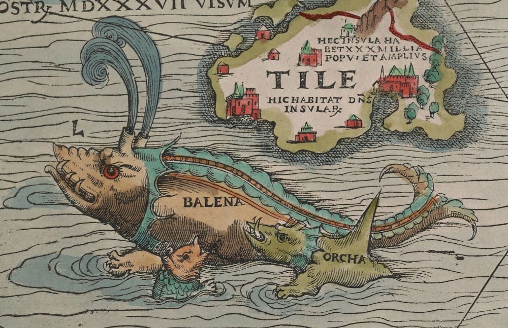
Fear and loathing for sea monsters
Within the collective imagination of the sixteenth century, enormous man-eating monsters commanded the oceans. Nowhere is this mashup of science and folklore de
mapmyths.com
September 29, 2025 at 4:17 PM
Follow the link below to uncover more about this iconic bestiary of the North Atlantic.
For Olaus and his contemporaries, the sea was not an empty void but a living, dangerous, and mysterious domain. The Age of Discovery was just beginning, and many of the animals depicted were considered to be real, albeit poorly understood, creatures.


September 29, 2025 at 4:17 PM
For Olaus and his contemporaries, the sea was not an empty void but a living, dangerous, and mysterious domain. The Age of Discovery was just beginning, and many of the animals depicted were considered to be real, albeit poorly understood, creatures.
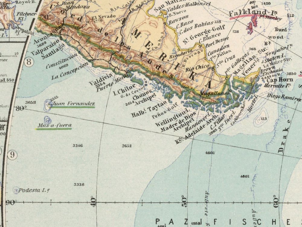
The micronation of Rino Island, founded in 2009, supposedly claims sovereignty over Podesta Island to this day, along with other phantom islands of the South Pacific.
Declaracion de Soberania sobre la Isla Podesta, la Roca Emily
Micronación sudamericana establecida en 2009, formada por una serie de islas del Océano Pacífico y un Territorio de Ultramar.
rinoislandgov.blogspot.com
September 23, 2025 at 3:20 PM
The micronation of Rino Island, founded in 2009, supposedly claims sovereignty over Podesta Island to this day, along with other phantom islands of the South Pacific.
The US Hydrographic Office list of 1891 had already marked Podesta Island as 'probably non-existent' after several ships had failed to find it again.
Yet the island still persisted on charts through the 20th century, and remarkably still remains on Google Maps with a not too undecent rating of 3.8.
Yet the island still persisted on charts through the 20th century, and remarkably still remains on Google Maps with a not too undecent rating of 3.8.

September 23, 2025 at 3:20 PM
The US Hydrographic Office list of 1891 had already marked Podesta Island as 'probably non-existent' after several ships had failed to find it again.
Yet the island still persisted on charts through the 20th century, and remarkably still remains on Google Maps with a not too undecent rating of 3.8.
Yet the island still persisted on charts through the 20th century, and remarkably still remains on Google Maps with a not too undecent rating of 3.8.