


Quentin E. Cummings, AICP, GISP, CFM
@makedataspatial.bsky.social
Professional in sustainability, climate mitigation & adaptation, and Geospatial Information Sciences & Technology (GIS&T). Planning commissioner. Housing affordability advocate.
Day 1 #30DayMapChallenge
Mapping the countless homes in the US where a language other than English is spoken; a tribute to immigrant voices.
From the first foreign-language newspaper in 1732 through thousands by 1900, the US's story is multilingual.
Full post: www.linkedin.com/posts/quenti...
Mapping the countless homes in the US where a language other than English is spoken; a tribute to immigrant voices.
From the first foreign-language newspaper in 1732 through thousands by 1900, the US's story is multilingual.
Full post: www.linkedin.com/posts/quenti...

November 2, 2025 at 4:04 AM
Day 1 #30DayMapChallenge
Mapping the countless homes in the US where a language other than English is spoken; a tribute to immigrant voices.
From the first foreign-language newspaper in 1732 through thousands by 1900, the US's story is multilingual.
Full post: www.linkedin.com/posts/quenti...
Mapping the countless homes in the US where a language other than English is spoken; a tribute to immigrant voices.
From the first foreign-language newspaper in 1732 through thousands by 1900, the US's story is multilingual.
Full post: www.linkedin.com/posts/quenti...
Join retired and former USAID and State Dept. staff, implementers, and supporters of US foreign
aid on February 5th from 11:30-12:30 to protest the
halt in foreign aid assistance.
UPPER SENATE PARK
CONSTITUTION & DELAWARE AVES NE
WEDNESDAY, FEBRUARY 5
11:30 AM
aid on February 5th from 11:30-12:30 to protest the
halt in foreign aid assistance.
UPPER SENATE PARK
CONSTITUTION & DELAWARE AVES NE
WEDNESDAY, FEBRUARY 5
11:30 AM

February 4, 2025 at 9:40 PM
Join retired and former USAID and State Dept. staff, implementers, and supporters of US foreign
aid on February 5th from 11:30-12:30 to protest the
halt in foreign aid assistance.
UPPER SENATE PARK
CONSTITUTION & DELAWARE AVES NE
WEDNESDAY, FEBRUARY 5
11:30 AM
aid on February 5th from 11:30-12:30 to protest the
halt in foreign aid assistance.
UPPER SENATE PARK
CONSTITUTION & DELAWARE AVES NE
WEDNESDAY, FEBRUARY 5
11:30 AM
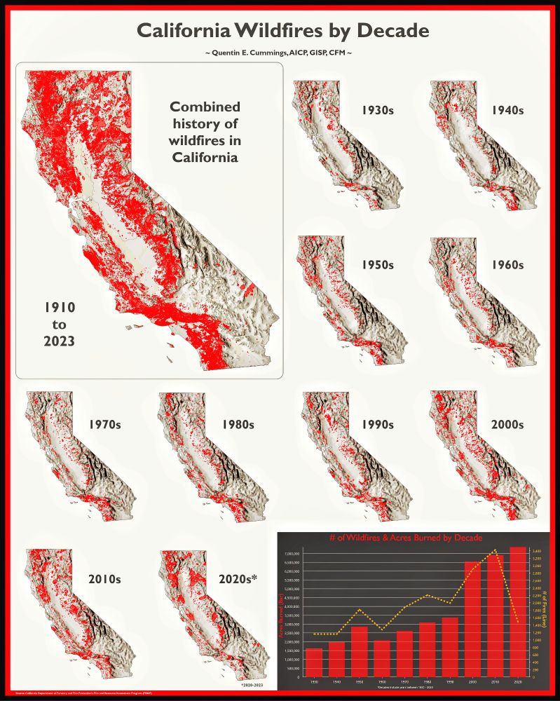
Wildfires in California have grown more frequent and devastating over the last century, fueled by several factors:
🔥 Climate Change
🔥 Development into the Wildland-Urban Interface (WUI)
🔥 Conflagration
lnkd.in/eH7w_AVv
#Wildfire #ClimateChange #WUI #Resilience #FirstResponders
🔥 Climate Change
🔥 Development into the Wildland-Urban Interface (WUI)
🔥 Conflagration
lnkd.in/eH7w_AVv
#Wildfire #ClimateChange #WUI #Resilience #FirstResponders
January 15, 2025 at 7:58 PM
Wildfires in California have grown more frequent and devastating over the last century, fueled by several factors:
🔥 Climate Change
🔥 Development into the Wildland-Urban Interface (WUI)
🔥 Conflagration
lnkd.in/eH7w_AVv
#Wildfire #ClimateChange #WUI #Resilience #FirstResponders
🔥 Climate Change
🔥 Development into the Wildland-Urban Interface (WUI)
🔥 Conflagration
lnkd.in/eH7w_AVv
#Wildfire #ClimateChange #WUI #Resilience #FirstResponders
Day 27 #30DayMapChallenge: Micromapping
Today’s challenge was all about mapping something on a much smaller scale than usual, so I turned to one of my favorite pastimes (outside of mapping, of course): tennis.
Longer post: bit.ly/3OBlfXL
#Tennis #GIS #ArcGISPro
Today’s challenge was all about mapping something on a much smaller scale than usual, so I turned to one of my favorite pastimes (outside of mapping, of course): tennis.
Longer post: bit.ly/3OBlfXL
#Tennis #GIS #ArcGISPro

November 30, 2024 at 11:00 PM
Day 27 #30DayMapChallenge: Micromapping
Today’s challenge was all about mapping something on a much smaller scale than usual, so I turned to one of my favorite pastimes (outside of mapping, of course): tennis.
Longer post: bit.ly/3OBlfXL
#Tennis #GIS #ArcGISPro
Today’s challenge was all about mapping something on a much smaller scale than usual, so I turned to one of my favorite pastimes (outside of mapping, of course): tennis.
Longer post: bit.ly/3OBlfXL
#Tennis #GIS #ArcGISPro
Day 26 of the #30DayMapChallenge: Projections
“All models are wrong, but some are useful.” This is especially true for maps. While often viewed as objective truths, maps are shaped by countless choices that can influence how viewers interpret them.
More at: bit.ly/4fS03sm
#GIS #DataViz #ArcGISPro
“All models are wrong, but some are useful.” This is especially true for maps. While often viewed as objective truths, maps are shaped by countless choices that can influence how viewers interpret them.
More at: bit.ly/4fS03sm
#GIS #DataViz #ArcGISPro

November 30, 2024 at 4:07 PM
Day 26 of the #30DayMapChallenge: Projections
“All models are wrong, but some are useful.” This is especially true for maps. While often viewed as objective truths, maps are shaped by countless choices that can influence how viewers interpret them.
More at: bit.ly/4fS03sm
#GIS #DataViz #ArcGISPro
“All models are wrong, but some are useful.” This is especially true for maps. While often viewed as objective truths, maps are shaped by countless choices that can influence how viewers interpret them.
More at: bit.ly/4fS03sm
#GIS #DataViz #ArcGISPro
Day 25 of the #30DayMapChallenge: Heat
Left & right columns are variables used to create composite indices found in top center. Bottom center is a bivariate map of the indices: physical (heat) & demographic vulnerabilities.
bit.ly/4iajONr
#ExtremeHeat #GIS #Climate #Chicago #DataViz #ArcGISPro
Left & right columns are variables used to create composite indices found in top center. Bottom center is a bivariate map of the indices: physical (heat) & demographic vulnerabilities.
bit.ly/4iajONr
#ExtremeHeat #GIS #Climate #Chicago #DataViz #ArcGISPro

November 30, 2024 at 11:55 AM
Day 25 of the #30DayMapChallenge: Heat
Left & right columns are variables used to create composite indices found in top center. Bottom center is a bivariate map of the indices: physical (heat) & demographic vulnerabilities.
bit.ly/4iajONr
#ExtremeHeat #GIS #Climate #Chicago #DataViz #ArcGISPro
Left & right columns are variables used to create composite indices found in top center. Bottom center is a bivariate map of the indices: physical (heat) & demographic vulnerabilities.
bit.ly/4iajONr
#ExtremeHeat #GIS #Climate #Chicago #DataViz #ArcGISPro
Day 24 #30DayMapChallenge: Circular Shapes
A circular globe, circular legend, & background full of circular stars & galaxies. Take that, flat earthers 😎
Data -> @freedomhouse.bsky.social based on:
1) Electoral process
2) Political pluralism & participation
3) Functioning of government
#ArcGISPro
A circular globe, circular legend, & background full of circular stars & galaxies. Take that, flat earthers 😎
Data -> @freedomhouse.bsky.social based on:
1) Electoral process
2) Political pluralism & participation
3) Functioning of government
#ArcGISPro

November 29, 2024 at 11:16 PM
Day 24 #30DayMapChallenge: Circular Shapes
A circular globe, circular legend, & background full of circular stars & galaxies. Take that, flat earthers 😎
Data -> @freedomhouse.bsky.social based on:
1) Electoral process
2) Political pluralism & participation
3) Functioning of government
#ArcGISPro
A circular globe, circular legend, & background full of circular stars & galaxies. Take that, flat earthers 😎
Data -> @freedomhouse.bsky.social based on:
1) Electoral process
2) Political pluralism & participation
3) Functioning of government
#ArcGISPro
Day 23 #30DayMapChallenge: Memory
Mapped memories from 1 of my #military deployments. Mission: stabilize the region by working w/ local govts to build #infrastructure necessary for #communities to care for, educate, employ & protect their people.
More: bit.ly/49f9ujc
#GIS #ArcGISPro #Afghanistan
Mapped memories from 1 of my #military deployments. Mission: stabilize the region by working w/ local govts to build #infrastructure necessary for #communities to care for, educate, employ & protect their people.
More: bit.ly/49f9ujc
#GIS #ArcGISPro #Afghanistan

November 29, 2024 at 8:53 PM
Day 23 #30DayMapChallenge: Memory
Mapped memories from 1 of my #military deployments. Mission: stabilize the region by working w/ local govts to build #infrastructure necessary for #communities to care for, educate, employ & protect their people.
More: bit.ly/49f9ujc
#GIS #ArcGISPro #Afghanistan
Mapped memories from 1 of my #military deployments. Mission: stabilize the region by working w/ local govts to build #infrastructure necessary for #communities to care for, educate, employ & protect their people.
More: bit.ly/49f9ujc
#GIS #ArcGISPro #Afghanistan
Day 22 of the #30DayMapChallenge: 2 Colors
I used just 2 colors to map the North American Rail Network #NARN, a dataset from the National #NGDA, provided by the #BTS.
Longer post: bit.ly/4ianM8M
#Railroads #Transportation #Infrastructure #GIS #ArcGISPro
I used just 2 colors to map the North American Rail Network #NARN, a dataset from the National #NGDA, provided by the #BTS.
Longer post: bit.ly/4ianM8M
#Railroads #Transportation #Infrastructure #GIS #ArcGISPro

November 29, 2024 at 9:51 AM
Day 22 of the #30DayMapChallenge: 2 Colors
I used just 2 colors to map the North American Rail Network #NARN, a dataset from the National #NGDA, provided by the #BTS.
Longer post: bit.ly/4ianM8M
#Railroads #Transportation #Infrastructure #GIS #ArcGISPro
I used just 2 colors to map the North American Rail Network #NARN, a dataset from the National #NGDA, provided by the #BTS.
Longer post: bit.ly/4ianM8M
#Railroads #Transportation #Infrastructure #GIS #ArcGISPro
Day 21 of the #30DayMapChallenge: #Conflict
Focus: #Kurdistan. A land w/out official borders but home to the Kurdish people—a group with a rich history, culture, & enduring struggle for recognition.
Longer post: bit.ly/498vI6t
#Kurds #Iraq #Iran #Syria #Türkiye #Turkey #Armenia #GIS #ArcGISPro
Focus: #Kurdistan. A land w/out official borders but home to the Kurdish people—a group with a rich history, culture, & enduring struggle for recognition.
Longer post: bit.ly/498vI6t
#Kurds #Iraq #Iran #Syria #Türkiye #Turkey #Armenia #GIS #ArcGISPro

November 28, 2024 at 3:58 PM
Day 21 of the #30DayMapChallenge: #Conflict
Focus: #Kurdistan. A land w/out official borders but home to the Kurdish people—a group with a rich history, culture, & enduring struggle for recognition.
Longer post: bit.ly/498vI6t
#Kurds #Iraq #Iran #Syria #Türkiye #Turkey #Armenia #GIS #ArcGISPro
Focus: #Kurdistan. A land w/out official borders but home to the Kurdish people—a group with a rich history, culture, & enduring struggle for recognition.
Longer post: bit.ly/498vI6t
#Kurds #Iraq #Iran #Syria #Türkiye #Turkey #Armenia #GIS #ArcGISPro
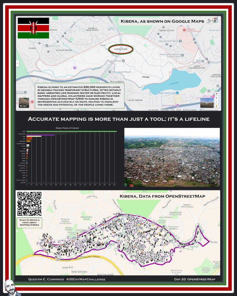
Day 20 of the #30DayMapChallenge: OpenStreetMap
I focused on Kibera, an informal settlement in Nairobi, Kenya, often described as one of the largest urban slums in Africa. Being "on the map" matters.
Longer post: bit.ly/3V9tON2
#OSM #GIS #Kibera #Kenya #ArcGISPro
I focused on Kibera, an informal settlement in Nairobi, Kenya, often described as one of the largest urban slums in Africa. Being "on the map" matters.
Longer post: bit.ly/3V9tON2
#OSM #GIS #Kibera #Kenya #ArcGISPro
November 28, 2024 at 3:54 PM
Day 20 of the #30DayMapChallenge: OpenStreetMap
I focused on Kibera, an informal settlement in Nairobi, Kenya, often described as one of the largest urban slums in Africa. Being "on the map" matters.
Longer post: bit.ly/3V9tON2
#OSM #GIS #Kibera #Kenya #ArcGISPro
I focused on Kibera, an informal settlement in Nairobi, Kenya, often described as one of the largest urban slums in Africa. Being "on the map" matters.
Longer post: bit.ly/3V9tON2
#OSM #GIS #Kibera #Kenya #ArcGISPro
Day 19 of the #30DayMapChallenge: Typography
Got creative with typography by making a map where the streets themselves are words. The focus? Washington, DC, the nation’s capital, a city rich in history and intrigue.
To learn more about DC: bit.ly/4fMlTO4
#WashingtonDC #GIS #ArcGISPro
Got creative with typography by making a map where the streets themselves are words. The focus? Washington, DC, the nation’s capital, a city rich in history and intrigue.
To learn more about DC: bit.ly/4fMlTO4
#WashingtonDC #GIS #ArcGISPro

November 28, 2024 at 3:49 PM
Day 19 of the #30DayMapChallenge: Typography
Got creative with typography by making a map where the streets themselves are words. The focus? Washington, DC, the nation’s capital, a city rich in history and intrigue.
To learn more about DC: bit.ly/4fMlTO4
#WashingtonDC #GIS #ArcGISPro
Got creative with typography by making a map where the streets themselves are words. The focus? Washington, DC, the nation’s capital, a city rich in history and intrigue.
To learn more about DC: bit.ly/4fMlTO4
#WashingtonDC #GIS #ArcGISPro
Day 18 of the #30DayMapChallenge: 3D
For today’s challenge, I decided to dive into some trippy 3D effects using contours, and what better city to showcase than one of my favorites: Pittsburgh 🏈🏒⚾
Longer post: bit.ly/3ZasiLZ
#Pittsburgh #SteelCity #GIS #ArcGISPro
For today’s challenge, I decided to dive into some trippy 3D effects using contours, and what better city to showcase than one of my favorites: Pittsburgh 🏈🏒⚾
Longer post: bit.ly/3ZasiLZ
#Pittsburgh #SteelCity #GIS #ArcGISPro

November 28, 2024 at 3:45 PM
Day 18 of the #30DayMapChallenge: 3D
For today’s challenge, I decided to dive into some trippy 3D effects using contours, and what better city to showcase than one of my favorites: Pittsburgh 🏈🏒⚾
Longer post: bit.ly/3ZasiLZ
#Pittsburgh #SteelCity #GIS #ArcGISPro
For today’s challenge, I decided to dive into some trippy 3D effects using contours, and what better city to showcase than one of my favorites: Pittsburgh 🏈🏒⚾
Longer post: bit.ly/3ZasiLZ
#Pittsburgh #SteelCity #GIS #ArcGISPro
Day 17 of the #30DayMapChallenge: Collaborative Map
I pulled from my Google Maps saved locations, a collection that’s grown from collaborating with friends - planning vacations, discovering food spots, etc., maps have been at the ❤️ of our adventures.
Longer post: bit.ly/4fMROhk
#GIS #ArcGISPro
I pulled from my Google Maps saved locations, a collection that’s grown from collaborating with friends - planning vacations, discovering food spots, etc., maps have been at the ❤️ of our adventures.
Longer post: bit.ly/4fMROhk
#GIS #ArcGISPro

November 28, 2024 at 3:40 PM
Day 17 of the #30DayMapChallenge: Collaborative Map
I pulled from my Google Maps saved locations, a collection that’s grown from collaborating with friends - planning vacations, discovering food spots, etc., maps have been at the ❤️ of our adventures.
Longer post: bit.ly/4fMROhk
#GIS #ArcGISPro
I pulled from my Google Maps saved locations, a collection that’s grown from collaborating with friends - planning vacations, discovering food spots, etc., maps have been at the ❤️ of our adventures.
Longer post: bit.ly/4fMROhk
#GIS #ArcGISPro
Day 16 of the #30DayMapChallenge: Choropleth
The inspiration for today’s map came from a conversation with a friend. She joked, “Can you make a map of where all the single people are?” Challenge accepted! 😂
To learn more: bit.ly/3Z7ncjv
#GIS #ArcGISPro #single
The inspiration for today’s map came from a conversation with a friend. She joked, “Can you make a map of where all the single people are?” Challenge accepted! 😂
To learn more: bit.ly/3Z7ncjv
#GIS #ArcGISPro #single

November 28, 2024 at 3:34 PM
Day 16 of the #30DayMapChallenge: Choropleth
The inspiration for today’s map came from a conversation with a friend. She joked, “Can you make a map of where all the single people are?” Challenge accepted! 😂
To learn more: bit.ly/3Z7ncjv
#GIS #ArcGISPro #single
The inspiration for today’s map came from a conversation with a friend. She joked, “Can you make a map of where all the single people are?” Challenge accepted! 😂
To learn more: bit.ly/3Z7ncjv
#GIS #ArcGISPro #single
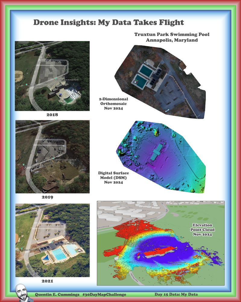
Day 15 of the #30DayMapChallenge: My Data
I created a map using data I personally collected with a #drone today. Drones—where implemented—have revolutionized how we can capture and analyze spatial data.
To learn more: bit.ly/3CNHcAd
#RemoteSensing #Orthomosaics #ArcGISPro
I created a map using data I personally collected with a #drone today. Drones—where implemented—have revolutionized how we can capture and analyze spatial data.
To learn more: bit.ly/3CNHcAd
#RemoteSensing #Orthomosaics #ArcGISPro
November 28, 2024 at 3:30 PM
Day 15 of the #30DayMapChallenge: My Data
I created a map using data I personally collected with a #drone today. Drones—where implemented—have revolutionized how we can capture and analyze spatial data.
To learn more: bit.ly/3CNHcAd
#RemoteSensing #Orthomosaics #ArcGISPro
I created a map using data I personally collected with a #drone today. Drones—where implemented—have revolutionized how we can capture and analyze spatial data.
To learn more: bit.ly/3CNHcAd
#RemoteSensing #Orthomosaics #ArcGISPro
Day 14 of the #30DayMapChallenge: A World Map
With recent events, I wanted to speak to our shared origins. While my artistic skills might need some work, I think my heart is in the right place.
May we all remember & embrace our common humanity.
Longer post: bit.ly/3Ouo2lm
#Africa #GIS
With recent events, I wanted to speak to our shared origins. While my artistic skills might need some work, I think my heart is in the right place.
May we all remember & embrace our common humanity.
Longer post: bit.ly/3Ouo2lm
#Africa #GIS

November 28, 2024 at 3:25 PM
Day 14 of the #30DayMapChallenge: A World Map
With recent events, I wanted to speak to our shared origins. While my artistic skills might need some work, I think my heart is in the right place.
May we all remember & embrace our common humanity.
Longer post: bit.ly/3Ouo2lm
#Africa #GIS
With recent events, I wanted to speak to our shared origins. While my artistic skills might need some work, I think my heart is in the right place.
May we all remember & embrace our common humanity.
Longer post: bit.ly/3Ouo2lm
#Africa #GIS
Day 13 of the #30DayMapChallenge: A New Tool
My thoughts go out to the Asheville, NC area & all impacted by #Helene. I worked with the #Flood Simulation tool in #ArcGISPro, a relatively new resource that some may not yet know about.
To learn more about my analysis: bit.ly/3VezIwx
#Climate
My thoughts go out to the Asheville, NC area & all impacted by #Helene. I worked with the #Flood Simulation tool in #ArcGISPro, a relatively new resource that some may not yet know about.
To learn more about my analysis: bit.ly/3VezIwx
#Climate

November 28, 2024 at 3:19 PM
Day 13 of the #30DayMapChallenge: A New Tool
My thoughts go out to the Asheville, NC area & all impacted by #Helene. I worked with the #Flood Simulation tool in #ArcGISPro, a relatively new resource that some may not yet know about.
To learn more about my analysis: bit.ly/3VezIwx
#Climate
My thoughts go out to the Asheville, NC area & all impacted by #Helene. I worked with the #Flood Simulation tool in #ArcGISPro, a relatively new resource that some may not yet know about.
To learn more about my analysis: bit.ly/3VezIwx
#Climate
Day 12 of the #30DayMapChallenge: Time & Space
Space Time Cubes open up incredible possibilities for analyzing trends & patterns. For this map, I applied it to #earthquake data in #Alaska—the most seismically active state in the U.S.
To learn more: bit.ly/3VejiUG
#ArcGISPro
Space Time Cubes open up incredible possibilities for analyzing trends & patterns. For this map, I applied it to #earthquake data in #Alaska—the most seismically active state in the U.S.
To learn more: bit.ly/3VejiUG
#ArcGISPro

November 28, 2024 at 3:02 PM
Day 12 of the #30DayMapChallenge: Time & Space
Space Time Cubes open up incredible possibilities for analyzing trends & patterns. For this map, I applied it to #earthquake data in #Alaska—the most seismically active state in the U.S.
To learn more: bit.ly/3VejiUG
#ArcGISPro
Space Time Cubes open up incredible possibilities for analyzing trends & patterns. For this map, I applied it to #earthquake data in #Alaska—the most seismically active state in the U.S.
To learn more: bit.ly/3VejiUG
#ArcGISPro
Day 11 of the #30DayMapChallenge: Arctic
Today’s theme took us to a region facing dramatic changes with profound global impacts. I created a map showing the decreasing Annual Arctic Sea Ice Minimum Extent from 1980 to present.
To learn more: bit.ly/4g5RHNr
#Arctic #COP29 #Climate #ArcGISPro
Today’s theme took us to a region facing dramatic changes with profound global impacts. I created a map showing the decreasing Annual Arctic Sea Ice Minimum Extent from 1980 to present.
To learn more: bit.ly/4g5RHNr
#Arctic #COP29 #Climate #ArcGISPro

November 28, 2024 at 2:57 PM
Day 11 of the #30DayMapChallenge: Arctic
Today’s theme took us to a region facing dramatic changes with profound global impacts. I created a map showing the decreasing Annual Arctic Sea Ice Minimum Extent from 1980 to present.
To learn more: bit.ly/4g5RHNr
#Arctic #COP29 #Climate #ArcGISPro
Today’s theme took us to a region facing dramatic changes with profound global impacts. I created a map showing the decreasing Annual Arctic Sea Ice Minimum Extent from 1980 to present.
To learn more: bit.ly/4g5RHNr
#Arctic #COP29 #Climate #ArcGISPro
Day 10 of the #30DayMapChallenge: Pen & Paper
My handwriting/art could be classified as a secret code. So, I decided to cheat a little and created a digital version that somewhat looks like a drawing of my city, Annapolis.
Longer post: bit.ly/3OulLqk
#PenAndPaper #Annapolis #Maryland #ArcGISPro
My handwriting/art could be classified as a secret code. So, I decided to cheat a little and created a digital version that somewhat looks like a drawing of my city, Annapolis.
Longer post: bit.ly/3OulLqk
#PenAndPaper #Annapolis #Maryland #ArcGISPro

November 28, 2024 at 2:53 PM
Day 10 of the #30DayMapChallenge: Pen & Paper
My handwriting/art could be classified as a secret code. So, I decided to cheat a little and created a digital version that somewhat looks like a drawing of my city, Annapolis.
Longer post: bit.ly/3OulLqk
#PenAndPaper #Annapolis #Maryland #ArcGISPro
My handwriting/art could be classified as a secret code. So, I decided to cheat a little and created a digital version that somewhat looks like a drawing of my city, Annapolis.
Longer post: bit.ly/3OulLqk
#PenAndPaper #Annapolis #Maryland #ArcGISPro
Day 9 of the #30DayMapChallenge: Artificial Intelligence
I experimented with blending AI-generated design with #GIS to create a vintage-style map of Europe, to establish GCP to georeference the AI-generated image.
To learn more: bit.ly/3ZnQStX
#ArcGISPro
I experimented with blending AI-generated design with #GIS to create a vintage-style map of Europe, to establish GCP to georeference the AI-generated image.
To learn more: bit.ly/3ZnQStX
#ArcGISPro

November 28, 2024 at 2:47 PM
Day 9 of the #30DayMapChallenge: Artificial Intelligence
I experimented with blending AI-generated design with #GIS to create a vintage-style map of Europe, to establish GCP to georeference the AI-generated image.
To learn more: bit.ly/3ZnQStX
#ArcGISPro
I experimented with blending AI-generated design with #GIS to create a vintage-style map of Europe, to establish GCP to georeference the AI-generated image.
To learn more: bit.ly/3ZnQStX
#ArcGISPro
Day 8 of the #30DayMapChallenge: Humanitarian Data Exchange
I wrestled with whether to highlight the crisis in Gaza, knowing how polarizing the subject can be. But many of us entered the GIS field to address difficult truths.
To see the #s: bit.ly/3ZdDirV
#ArcGISPro #Gaza #Palestine #Israel
I wrestled with whether to highlight the crisis in Gaza, knowing how polarizing the subject can be. But many of us entered the GIS field to address difficult truths.
To see the #s: bit.ly/3ZdDirV
#ArcGISPro #Gaza #Palestine #Israel

November 28, 2024 at 2:40 PM
Day 8 of the #30DayMapChallenge: Humanitarian Data Exchange
I wrestled with whether to highlight the crisis in Gaza, knowing how polarizing the subject can be. But many of us entered the GIS field to address difficult truths.
To see the #s: bit.ly/3ZdDirV
#ArcGISPro #Gaza #Palestine #Israel
I wrestled with whether to highlight the crisis in Gaza, knowing how polarizing the subject can be. But many of us entered the GIS field to address difficult truths.
To see the #s: bit.ly/3ZdDirV
#ArcGISPro #Gaza #Palestine #Israel
✨🗺 Day 7 of the #30DayMapChallenge: Vintage Style 🗺✨
I dove into the world of bifocal hemisphere maps—a classic in early cartography that brings both beauty and practicality to global visualization.
Click to learn more: bit.ly/4fRWKSg
#Esri #LivingAtlas #DataViz #Art #ArcGISPro
I dove into the world of bifocal hemisphere maps—a classic in early cartography that brings both beauty and practicality to global visualization.
Click to learn more: bit.ly/4fRWKSg
#Esri #LivingAtlas #DataViz #Art #ArcGISPro

November 28, 2024 at 5:39 AM
✨🗺 Day 7 of the #30DayMapChallenge: Vintage Style 🗺✨
I dove into the world of bifocal hemisphere maps—a classic in early cartography that brings both beauty and practicality to global visualization.
Click to learn more: bit.ly/4fRWKSg
#Esri #LivingAtlas #DataViz #Art #ArcGISPro
I dove into the world of bifocal hemisphere maps—a classic in early cartography that brings both beauty and practicality to global visualization.
Click to learn more: bit.ly/4fRWKSg
#Esri #LivingAtlas #DataViz #Art #ArcGISPro
🌊✨ Day 6 of the #30DayMapChallenge: Raster ✨🌊
For today’s theme, I created a rasterized map of my favorite body of water—the Chesapeake Bay! Data source from USGS.
Click to learn more: bit.ly/3D00Yby
#ChesapeakeBay #Environment #GIS
For today’s theme, I created a rasterized map of my favorite body of water—the Chesapeake Bay! Data source from USGS.
Click to learn more: bit.ly/3D00Yby
#ChesapeakeBay #Environment #GIS

November 28, 2024 at 5:36 AM
🌊✨ Day 6 of the #30DayMapChallenge: Raster ✨🌊
For today’s theme, I created a rasterized map of my favorite body of water—the Chesapeake Bay! Data source from USGS.
Click to learn more: bit.ly/3D00Yby
#ChesapeakeBay #Environment #GIS
For today’s theme, I created a rasterized map of my favorite body of water—the Chesapeake Bay! Data source from USGS.
Click to learn more: bit.ly/3D00Yby
#ChesapeakeBay #Environment #GIS