


𝚖𝚊𝚌𝚔𝚊 𝚜𝚣𝚎𝚌𝚑𝚗𝚘
@mackaszechno.bsky.social
#rstats geospatial data analyst. GIS expert, of a sort. Sci-fi fan and would be writer. Black cat owner. Occasionally apocalyptical. Can't DM.
WORDS ARE QUICK AND WORDS ARE VAIN, THE SINGLE SURE AND FINAL ANSWER MUST BE PAIN. -Dan Simmons, Olympos
WORDS ARE QUICK AND WORDS ARE VAIN, THE SINGLE SURE AND FINAL ANSWER MUST BE PAIN. -Dan Simmons, Olympos
Another pic of Alice. She likes to wait at the door of my home office so she can follow me downstairs and demand treats.

November 22, 2025 at 10:00 PM
Another pic of Alice. She likes to wait at the door of my home office so she can follow me downstairs and demand treats.
My work setup. My process is constantly referring back to saved snippets of code that worked, reviewing help in RStudio and online, and deleting off all the non-working stuff until I get something I think is acceptable 😜
#30DayMapChallenge | Day 23 - Process
#30DayMapChallenge | Day 23 - Process

November 22, 2025 at 8:10 PM
My work setup. My process is constantly referring back to saved snippets of code that worked, reviewing help in RStudio and online, and deleting off all the non-working stuff until I get something I think is acceptable 😜
#30DayMapChallenge | Day 23 - Process
#30DayMapChallenge | Day 23 - Process
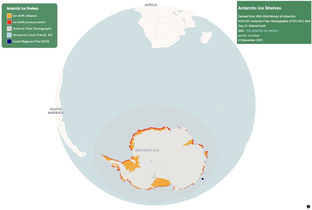
Ice shelf collapses in Antarctica using {mapgl}.
#30DayMapChallenge | Day 22 - Data challenge: Natural Earth #rstats
(code in reply)
#30DayMapChallenge | Day 22 - Data challenge: Natural Earth #rstats
(code in reply)

November 22, 2025 at 7:47 PM
Ice shelf collapses in Antarctica using {mapgl}.
#30DayMapChallenge | Day 22 - Data challenge: Natural Earth #rstats
(code in reply)
#30DayMapChallenge | Day 22 - Data challenge: Natural Earth #rstats
(code in reply)
Crawley and Gatwick...

November 21, 2025 at 3:09 PM
Crawley and Gatwick...

November 21, 2025 at 3:07 PM
Natural Earth to the rescue with rivers_lake_centerline, lakes, ocean, and bathy from 0-10000m.
#30DayMapChallenge | Day 20 - Water #rstats
(code in alt)
#30DayMapChallenge | Day 20 - Water #rstats
(code in alt)


November 20, 2025 at 6:10 PM
Natural Earth to the rescue with rivers_lake_centerline, lakes, ocean, and bathy from 0-10000m.
#30DayMapChallenge | Day 20 - Water #rstats
(code in alt)
#30DayMapChallenge | Day 20 - Water #rstats
(code in alt)
A day late due to man flu. West Sussex in one correct project (BNG 27700) and 3 inappropriate projections with area calculations showing how the deformation affects the total.
Note: I don't use {ggplot} much so plots are fairly basic.
#30DayMapChallenge | Day 19 - Projections #rstats
(code in alt)
Note: I don't use {ggplot} much so plots are fairly basic.
#30DayMapChallenge | Day 19 - Projections #rstats
(code in alt)

November 20, 2025 at 10:13 AM
A day late due to man flu. West Sussex in one correct project (BNG 27700) and 3 inappropriate projections with area calculations showing how the deformation affects the total.
Note: I don't use {ggplot} much so plots are fairly basic.
#30DayMapChallenge | Day 19 - Projections #rstats
(code in alt)
Note: I don't use {ggplot} much so plots are fairly basic.
#30DayMapChallenge | Day 19 - Projections #rstats
(code in alt)
Left a message on the moon too as a bit of a running gag...


November 18, 2025 at 9:40 PM
Left a message on the moon too as a bit of a running gag...
And a view of the moon in QGIS as a WMS layer courtesy of webmap.lroc.asu.edu. Instructions at lunaserv.im-ldi.com/getting_star....

November 18, 2025 at 9:18 PM
And a view of the moon in QGIS as a WMS layer courtesy of webmap.lroc.asu.edu. Instructions at lunaserv.im-ldi.com/getting_star....
Planning out interrelations between scenes, chapters, books, and associated notes.
#30DayMapChallenge | Day 18 - Out of this world #obsidian
#30DayMapChallenge | Day 18 - Out of this world #obsidian


November 18, 2025 at 9:14 PM
Planning out interrelations between scenes, chapters, books, and associated notes.
#30DayMapChallenge | Day 18 - Out of this world #obsidian
#30DayMapChallenge | Day 18 - Out of this world #obsidian
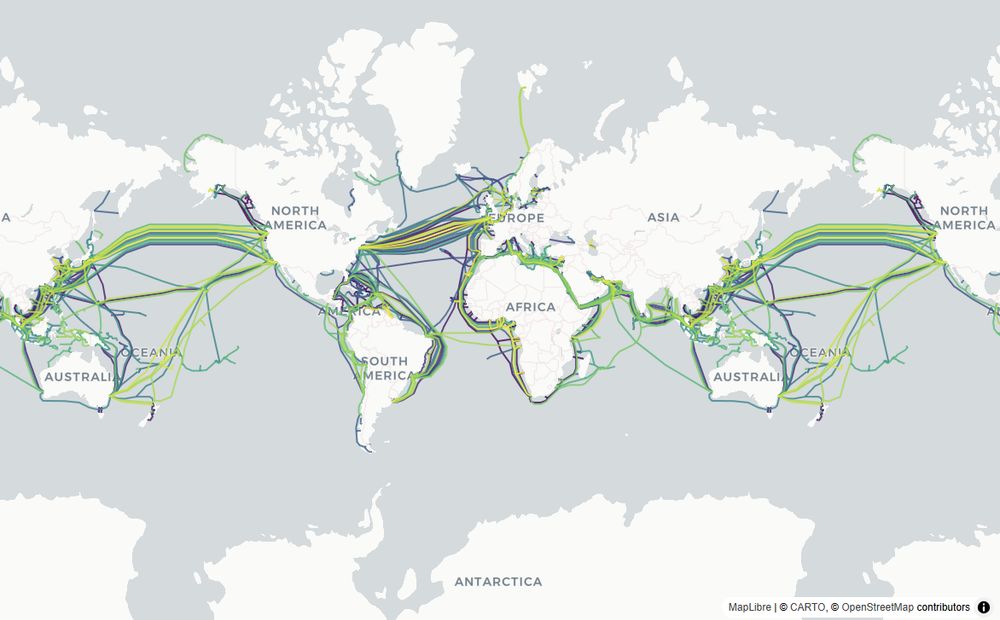
Okay, phoning this one in as got bored of all the necessary setup required to get Python spatial working, so kept to the absolute basics. Undersea cables in Python (image1) and with R (image2). Two lines of code in each.
#30DayMapChallenge | Day 17 - A new tool #python
(code in alt)
#30DayMapChallenge | Day 17 - A new tool #python
(code in alt)

November 17, 2025 at 3:48 PM
Okay, phoning this one in as got bored of all the necessary setup required to get Python spatial working, so kept to the absolute basics. Undersea cables in Python (image1) and with R (image2). Two lines of code in each.
#30DayMapChallenge | Day 17 - A new tool #python
(code in alt)
#30DayMapChallenge | Day 17 - A new tool #python
(code in alt)

Reusing ONS Output Areas with pop density data from Day 8 to create cells colour-coded to pop density. Also could be considered a 10-minute map as used only maplibre_view.
#30DayMapChallenge | Day 16 - Cells #rstats
(code in alt)
#30DayMapChallenge | Day 16 - Cells #rstats
(code in alt)

November 16, 2025 at 9:06 PM
Reusing ONS Output Areas with pop density data from Day 8 to create cells colour-coded to pop density. Also could be considered a 10-minute map as used only maplibre_view.
#30DayMapChallenge | Day 16 - Cells #rstats
(code in alt)
#30DayMapChallenge | Day 16 - Cells #rstats
(code in alt)
Now with megawatts as circle radius (still very basic).
November 15, 2025 at 10:11 PM
Now with megawatts as circle radius (still very basic).
Randomly found myself face-to-face with this culprit today following the wife's decision that we take the bus to Littlehampton during the unseasonably warm weather. Had to get a photo or two before leaving 🤣


November 15, 2025 at 9:43 PM
Randomly found myself face-to-face with this culprit today following the wife's decision that we take the bus to Littlehampton during the unseasonably warm weather. Had to get a photo or two before leaving 🤣
Okay in the end the simplest solution was to add in extra columns to the dataset, one for each decade ie S1920 for the 1920s, and then use set_filter to modify the original map.
Each section then becomes...
Each section then becomes...

November 15, 2025 at 9:06 PM
Okay in the end the simplest solution was to add in extra columns to the dataset, one for each decade ie S1920 for the 1920s, and then use set_filter to modify the original map.
Each section then becomes...
Each section then becomes...
Maplibre in storymap mode showing changes in fuel-types for power generation in the UK.
Kudos to @kylewalker.bsky.social for the {mapgl} package and examples 😁
Data: www.gov.uk/government/c...
#30DayMapChallenge | Day 15 - Fire #rstats
Kudos to @kylewalker.bsky.social for the {mapgl} package and examples 😁
Data: www.gov.uk/government/c...
#30DayMapChallenge | Day 15 - Fire #rstats
November 15, 2025 at 8:57 PM
Maplibre in storymap mode showing changes in fuel-types for power generation in the UK.
Kudos to @kylewalker.bsky.social for the {mapgl} package and examples 😁
Data: www.gov.uk/government/c...
#30DayMapChallenge | Day 15 - Fire #rstats
Kudos to @kylewalker.bsky.social for the {mapgl} package and examples 😁
Data: www.gov.uk/government/c...
#30DayMapChallenge | Day 15 - Fire #rstats
The exception that proves the rule?

November 14, 2025 at 10:36 PM
The exception that proves the rule?
Power Stations operational before or on 1920 in the UK.

November 14, 2025 at 9:21 PM
Power Stations operational before or on 1920 in the UK.
Okay, sometimes it feels like that episode of Angel when Wes has to translate four languages at once to arrive at the vague answer but I will never tire of how beautiful maplibre is and how accessible it is because of {mapgl} ❤️

November 14, 2025 at 9:16 PM
Okay, sometimes it feels like that episode of Angel when Wes has to translate four languages at once to arrive at the vague answer but I will never tire of how beautiful maplibre is and how accessible it is because of {mapgl} ❤️
![# replace specific character with na
# fecking bracket placement important
# 1. old style
mutate(across(site:fuel, ~ifelse(. == "[x]", NA, .)))
# 2. new style
mutate(across(site:fuel, \(x) ifelse(x == "[x]", NA, x)))
# and repeated using set_units on character column
d |> mutate(across(start:end, \(x) x |> as.integer() |> set_units("Year")))](https://cdn.bsky.app/img/feed_thumbnail/plain/did:plc:lxpjtgfvz63z7zauo673qkfo/bafkreige37iuwhmcwyf43h63boy3mozujjokzwtwob6hlumr7gozr5jgem@jpeg)
Shinyapp using OSM data showing.
#30DayMapChallenge | Day 14 - Data challenge: OpenStreetMap #rstats
(key:values in alt)
#30DayMapChallenge | Day 14 - Data challenge: OpenStreetMap #rstats
(key:values in alt)

November 14, 2025 at 9:37 AM
Shinyapp using OSM data showing.
#30DayMapChallenge | Day 14 - Data challenge: OpenStreetMap #rstats
(key:values in alt)
#30DayMapChallenge | Day 14 - Data challenge: OpenStreetMap #rstats
(key:values in alt)
Ah, so different tags in OpenStreetMap
Tag:tunnel=culvert and, possibly, name includes 'beck'... ie 'Clow Beck' which appears as waterway:river.
Try this link for becks: www.openstreetmap.org/search?query...
Tag:tunnel=culvert and, possibly, name includes 'beck'... ie 'Clow Beck' which appears as waterway:river.
Try this link for becks: www.openstreetmap.org/search?query...

November 13, 2025 at 2:22 PM
Ah, so different tags in OpenStreetMap
Tag:tunnel=culvert and, possibly, name includes 'beck'... ie 'Clow Beck' which appears as waterway:river.
Try this link for becks: www.openstreetmap.org/search?query...
Tag:tunnel=culvert and, possibly, name includes 'beck'... ie 'Clow Beck' which appears as waterway:river.
Try this link for becks: www.openstreetmap.org/search?query...
Used in conjunction with the EA's Northumbria dataset...
Any use? If so, I'll tidy up and email you a copy.
Any use? If so, I'll tidy up and email you a copy.


November 13, 2025 at 11:37 AM
Used in conjunction with the EA's Northumbria dataset...
Any use? If so, I'll tidy up and email you a copy.
Any use? If so, I'll tidy up and email you a copy.
Prime Meridian displayed against backdrop of all time zones. Plus image of a magnet I brought back with me from Greenwich a couple of years ago :)
#30DayMapChallenge | Day 13 - 10 minute map #rstats
(code in alt)
#30DayMapChallenge | Day 13 - 10 minute map #rstats
(code in alt)


November 13, 2025 at 9:23 AM
Prime Meridian displayed against backdrop of all time zones. Plus image of a magnet I brought back with me from Greenwich a couple of years ago :)
#30DayMapChallenge | Day 13 - 10 minute map #rstats
(code in alt)
#30DayMapChallenge | Day 13 - 10 minute map #rstats
(code in alt)