


Laura N. Sotomayor
@lauransotomayor.bsky.social
Currently PhD Geomatic Engineering at University of Tasmania. Remote sensing + Deep learning 🤓🌏🛰️--> https://linktr.ee/lauransotomayor

🏌🏻♀️Proud to share PhD project 'Mapping Ecosystem Resilience with High-Resolution Remote Sensing Data' was selected for the
NVIDIA Academic Grant Program 👩🏻💻
Thanks to #NVIDIA, I’ll have 1K A100 GPU-Hours on Brev 🚀 #NVIDIAGrant #DeepLearningAlgorithms #ComputerVision #Robotics #GenerativeAI @NVIDIAAIDev
NVIDIA Academic Grant Program 👩🏻💻
Thanks to #NVIDIA, I’ll have 1K A100 GPU-Hours on Brev 🚀 #NVIDIAGrant #DeepLearningAlgorithms #ComputerVision #Robotics #GenerativeAI @NVIDIAAIDev

September 19, 2025 at 11:14 AM
🏌🏻♀️Proud to share PhD project 'Mapping Ecosystem Resilience with High-Resolution Remote Sensing Data' was selected for the
NVIDIA Academic Grant Program 👩🏻💻
Thanks to #NVIDIA, I’ll have 1K A100 GPU-Hours on Brev 🚀 #NVIDIAGrant #DeepLearningAlgorithms #ComputerVision #Robotics #GenerativeAI @NVIDIAAIDev
NVIDIA Academic Grant Program 👩🏻💻
Thanks to #NVIDIA, I’ll have 1K A100 GPU-Hours on Brev 🚀 #NVIDIAGrant #DeepLearningAlgorithms #ComputerVision #Robotics #GenerativeAI @NVIDIAAIDev
Implementation of the Monte Carlo Dropout as Uncertainty estimation in FVC segmentation mapping 🗺️#DeepLearning #RemoteSensing
[6/8]
[6/8]

August 10, 2025 at 1:10 AM
Implementation of the Monte Carlo Dropout as Uncertainty estimation in FVC segmentation mapping 🗺️#DeepLearning #RemoteSensing
[6/8]
[6/8]
Cm-scale FVC maps🌱from our best CNN models predictions on 3072×3072 px UAS multispectral tiles for each site (site-specific models).
[5/8]
[5/8]

August 10, 2025 at 1:09 AM
Cm-scale FVC maps🌱from our best CNN models predictions on 3072×3072 px UAS multispectral tiles for each site (site-specific models).
[5/8]
[5/8]
Model generalisation & transferability 🛰️ We tested 2 setups (A & B) to see when site-specific models beat generic ones. Expanded discussion on limitations + showed how data augmentation can boost robustness as a proof-of-concept.
[4/8]
[4/8]

August 10, 2025 at 1:08 AM
Model generalisation & transferability 🛰️ We tested 2 setups (A & B) to see when site-specific models beat generic ones. Expanded discussion on limitations + showed how data augmentation can boost robustness as a proof-of-concept.
[4/8]
[4/8]
U-Net models were trained & validated with spatial block CV, including both site-specific and generic models across all sites, to produce more realistic and transferable evaluations. Random CV inflated performance estimates by up to 28%.
[3/8]
[3/8]

August 10, 2025 at 1:07 AM
U-Net models were trained & validated with spatial block CV, including both site-specific and generic models across all sites, to produce more realistic and transferable evaluations. Random CV inflated performance estimates by up to 28%.
[3/8]
[3/8]
🌱📍We tested our CNN approach at 3 AusPlots sites in Calperum Station, South Australia, each representing a different National Vegetation Information System (NVIS) vegetation type: A (low), C (medium), E (dense). Together they cover 29 ha of semi-arid landscape.
[2/8]
[2/8]

August 10, 2025 at 1:06 AM
🌱📍We tested our CNN approach at 3 AusPlots sites in Calperum Station, South Australia, each representing a different National Vegetation Information System (NVIS) vegetation type: A (low), C (medium), E (dense). Together they cover 29 ha of semi-arid landscape.
[2/8]
[2/8]

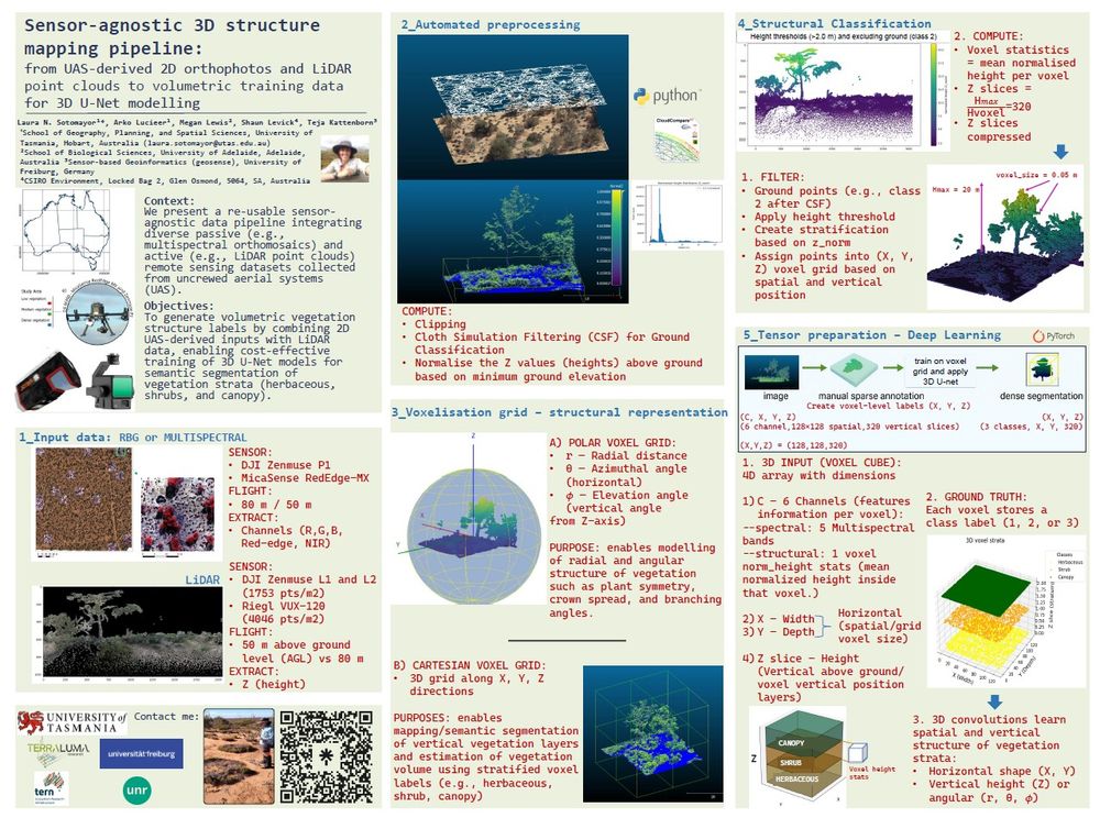
[Session BG9.2]"Remote Sensing for forest applications" Hall X1.73| 3D voxel cubes from #UAS imagery and #LiDAR to train a 3D U-Net for dense segmentation of vegetation strata, enabling scalable ecosystem mapping across sensors and landscapes.🌿📡 #RemoteSensing #DeepLearning #drone #EGU25 @egu.eu
April 29, 2025 at 6:50 AM
[Session BG9.2]"Remote Sensing for forest applications" Hall X1.73| 3D voxel cubes from #UAS imagery and #LiDAR to train a 3D U-Net for dense segmentation of vegetation strata, enabling scalable ecosystem mapping across sensors and landscapes.🌿📡 #RemoteSensing #DeepLearning #drone #EGU25 @egu.eu