


K Griffin
@kgriffin.dev
Meteorologist, homebrewer, Forward Madison, Chelsea, USA, AFC Wimbledon. Data data data.
The dozens (?) of NVDOT traffic cameras along the strip are a fun way to watch F1 qualifying without worrying about your ESPN subscription - all have real-time video feeds.
www.nvroads.com
www.nvroads.com

November 22, 2025 at 4:12 AM
The dozens (?) of NVDOT traffic cameras along the strip are a fun way to watch F1 qualifying without worrying about your ESPN subscription - all have real-time video feeds.
www.nvroads.com
www.nvroads.com
That's never a good way to start your day.

November 20, 2025 at 2:07 PM
That's never a good way to start your day.
Another sign of an intense event - when SWPC goes _hard_ down. Reminds of the NHC site during big events way back in the day.

November 12, 2025 at 3:44 AM
Another sign of an intense event - when SWPC goes _hard_ down. Reminds of the NHC site during big events way back in the day.
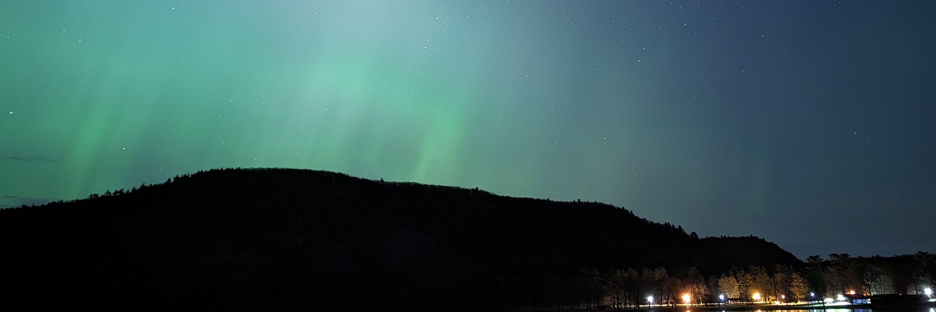
I already got some great clear-sky shots earlier this evening before the clouds came back in a second time, but views like this of the current substorm are just a tease

November 12, 2025 at 2:37 AM
I already got some great clear-sky shots earlier this evening before the clouds came back in a second time, but views like this of the current substorm are just a tease
This photo from Sept 2022 was surfaced to me and, uhm, I think we're going to need more of this beverage all too soon...

October 31, 2025 at 5:19 PM
This photo from Sept 2022 was surfaced to me and, uhm, I think we're going to need more of this beverage all too soon...
Nauseatingly intense winds. That ML150 value is likely what supported the 10a ET bump to 160kt.
Remember dropsonde winds are the equivalent of gusts, but 172kt gust at the surface is beyond insane.
Remember dropsonde winds are the equivalent of gusts, but 172kt gust at the surface is beyond insane.

October 28, 2025 at 2:27 PM
Nauseatingly intense winds. That ML150 value is likely what supported the 10a ET bump to 160kt.
Remember dropsonde winds are the equivalent of gusts, but 172kt gust at the surface is beyond insane.
Remember dropsonde winds are the equivalent of gusts, but 172kt gust at the surface is beyond insane.
Finally a dropsonde message got out. 892mb.
Lightning continues across much of the western semicircle.
Lightning continues across much of the western semicircle.

October 28, 2025 at 1:48 PM
Finally a dropsonde message got out. 892mb.
Lightning continues across much of the western semicircle.
Lightning continues across much of the western semicircle.
Must've been some mess that got made on the way through the eyewall to have this long of a hold inside the eye. Typically it's either a cleanup or, on occasion, an equipment check.
The up-and-down blue lines and low red line values in the top left chart indicates the time spent circling in the eye.
The up-and-down blue lines and low red line values in the top left chart indicates the time spent circling in the eye.


October 28, 2025 at 1:14 PM
Must've been some mess that got made on the way through the eyewall to have this long of a hold inside the eye. Typically it's either a cleanup or, on occasion, an equipment check.
The up-and-down blue lines and low red line values in the top left chart indicates the time spent circling in the eye.
The up-and-down blue lines and low red line values in the top left chart indicates the time spent circling in the eye.
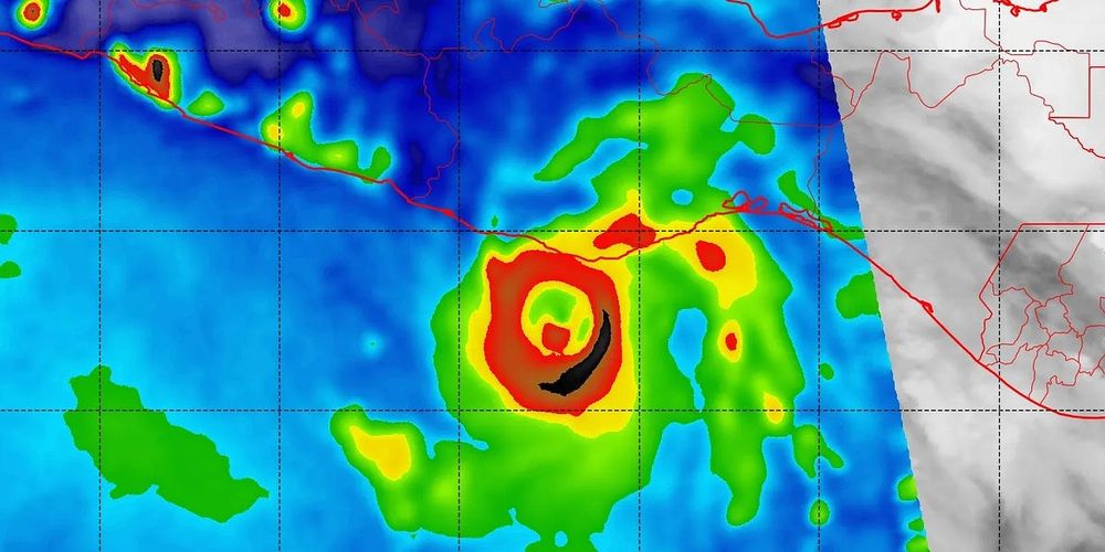
The satellite images remain unparalleled - yet also utterly sickening when you see the outline of Jamaica just a half degree of latitude (so, ~30 miles) north of the northern edge of the pink truck tire.
October 28, 2025 at 3:05 AM
The satellite images remain unparalleled - yet also utterly sickening when you see the outline of Jamaica just a half degree of latitude (so, ~30 miles) north of the northern edge of the pink truck tire.
Lightning only now beginning to encompass the entire eyewall of Melissa, or at least an uptick in lightning counts if you don't fully trust the GOES lightning mappers.

October 27, 2025 at 2:54 PM
Lightning only now beginning to encompass the entire eyewall of Melissa, or at least an uptick in lightning counts if you don't fully trust the GOES lightning mappers.
I've seen a lot of dropsondes over my years, and a peak wind of 210kt - even at the top of/just beyond the boundary layer - is wild to see. Might be up there in the ranks of all-time strongest dropsonde-measured gusts as well.

October 27, 2025 at 1:47 PM
I've seen a lot of dropsondes over my years, and a peak wind of 210kt - even at the top of/just beyond the boundary layer - is wild to see. Might be up there in the ranks of all-time strongest dropsonde-measured gusts as well.
The chargers on the AF 223 fleet has a leg up on the KLM 195s. Also makes sense given that AF bans all in-flight use of power banks.

September 19, 2025 at 12:35 PM
The chargers on the AF 223 fleet has a leg up on the KLM 195s. Also makes sense given that AF bans all in-flight use of power banks.
It might seem modern to only have the "universal" plug but these USB-A ports went out of style 5-10 years ago for charging. I don't even have a cable worthy of traveling that is compatible.

September 14, 2025 at 12:31 PM
It might seem modern to only have the "universal" plug but these USB-A ports went out of style 5-10 years ago for charging. I don't even have a cable worthy of traveling that is compatible.
This is one of the saddest public transit headlines I've ever seen.
Major sporting event? Either drive home from the massive parking lot, or take a train that can only run because of a sports betting company.
The SEPTA funding situation is so beyond sad at this point.
Major sporting event? Either drive home from the massive parking lot, or take a train that can only run because of a sports betting company.
The SEPTA funding situation is so beyond sad at this point.

September 4, 2025 at 3:58 PM
This is one of the saddest public transit headlines I've ever seen.
Major sporting event? Either drive home from the massive parking lot, or take a train that can only run because of a sports betting company.
The SEPTA funding situation is so beyond sad at this point.
Major sporting event? Either drive home from the massive parking lot, or take a train that can only run because of a sports betting company.
The SEPTA funding situation is so beyond sad at this point.
Reposted by K Griffin

Inter Miami is disgusting. Luis Suarez is disgusting. Spitting on a Sounders coach. #LeaguesCup #MLS
September 1, 2025 at 2:09 AM
Inter Miami is disgusting. Luis Suarez is disgusting. Spitting on a Sounders coach. #LeaguesCup #MLS
Reposted by K Griffin

Unbelievable footage from NOAA’s Hurricane Hunters inside the eye of Hurricane Erin.
Simply incredible.
Simply incredible.
August 16, 2025 at 9:22 PM
Unbelievable footage from NOAA’s Hurricane Hunters inside the eye of Hurricane Erin.
Simply incredible.
Simply incredible.

Reposted by K Griffin

The Corporation for Public Broadcasting is shutting down operations after loss of federal funding:

August 1, 2025 at 5:12 PM
The Corporation for Public Broadcasting is shutting down operations after loss of federal funding:
Lake Michigan is on the way.

July 4, 2025 at 12:51 AM
Lake Michigan is on the way.
Big @forwardmadisonfc.bsky.social win - three months after the last win, and the first at home, finally! Jacob Crull man of the match with all those headed clearances.
June 29, 2025 at 1:42 AM
Big @forwardmadisonfc.bsky.social win - three months after the last win, and the first at home, finally! Jacob Crull man of the match with all those headed clearances.
Reposted by K Griffin

Not going to lie, I cried a bit when I got the email that SSMIS was being discontinued. I developed D-MINT with a toddler in tow, showing her pretty pictures of hurricanes so she knew what Mommy did while she's playing with friends at school. This one hurts.
A huge blow was dealt to hurricane forecasters this week as a critical tool was abruptly terminated by the Department of Defense and NOAA. The immediate discontinuation of data from three weather satellites will severely impact hurricane forecasts this season and beyond. More ⬇️
Critical Hurricane Forecast Tool Abruptly Terminated
U.S. Department of Defense announced Tuesday it would no longer process and deliver data essential to most hurricane forecasts
michaelrlowry.substack.com
June 26, 2025 at 2:11 PM
Not going to lie, I cried a bit when I got the email that SSMIS was being discontinued. I developed D-MINT with a toddler in tow, showing her pretty pictures of hurricanes so she knew what Mommy did while she's playing with friends at school. This one hurts.
Reposted by K Griffin

A huge blow was dealt to hurricane forecasters this week as a critical tool was abruptly terminated by the Department of Defense and NOAA. The immediate discontinuation of data from three weather satellites will severely impact hurricane forecasts this season and beyond. More ⬇️
Critical Hurricane Forecast Tool Abruptly Terminated
U.S. Department of Defense announced Tuesday it would no longer process and deliver data essential to most hurricane forecasts
michaelrlowry.substack.com
June 26, 2025 at 1:17 PM
A huge blow was dealt to hurricane forecasters this week as a critical tool was abruptly terminated by the Department of Defense and NOAA. The immediate discontinuation of data from three weather satellites will severely impact hurricane forecasts this season and beyond. More ⬇️
Reposted by K Griffin

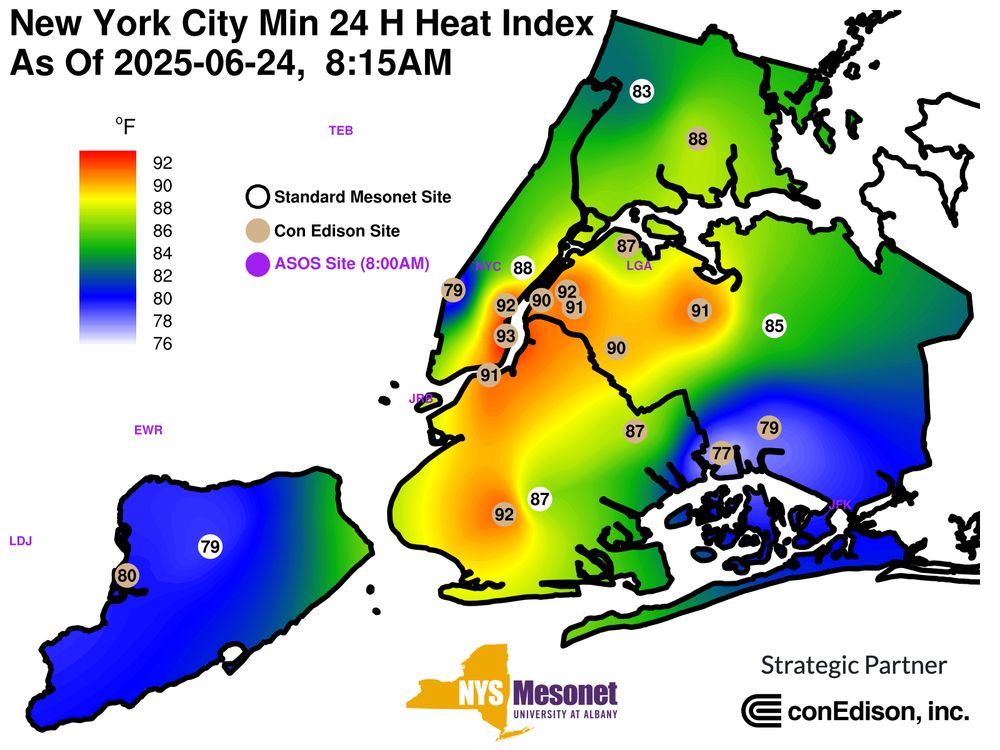
If you're in New York City and you're stepping out for work, to go vote, or just for a stroll ... it's possible you haven't experienced a below 90F feels-like temperature in over 24 hours. Today won't be any different.
Find a cooling center near you here: finder.nyc.gov/coolingcente...
Find a cooling center near you here: finder.nyc.gov/coolingcente...
June 24, 2025 at 12:27 PM
If you're in New York City and you're stepping out for work, to go vote, or just for a stroll ... it's possible you haven't experienced a below 90F feels-like temperature in over 24 hours. Today won't be any different.
Find a cooling center near you here: finder.nyc.gov/coolingcente...
Find a cooling center near you here: finder.nyc.gov/coolingcente...
Sure, it's already produced a gust to 101mph and has a rear inflow jet of 130mph+ and several tornadoes from that blob out ahead of it, and perhaps embedded in the main line as well, but JEEZ is this a beautiful confluence of dynamics in North Dakota tonight.

June 21, 2025 at 4:03 AM
Sure, it's already produced a gust to 101mph and has a rear inflow jet of 130mph+ and several tornadoes from that blob out ahead of it, and perhaps embedded in the main line as well, but JEEZ is this a beautiful confluence of dynamics in North Dakota tonight.
