


Jon Dollery
@jrdollery.bsky.social
Mapping Officer @rcahmwales.bsky.social | Landscape Archaeology | Historical GIS | Historical Cartography | FRGS | Board Game Enthusiast | Proud Cat Dad 🐱
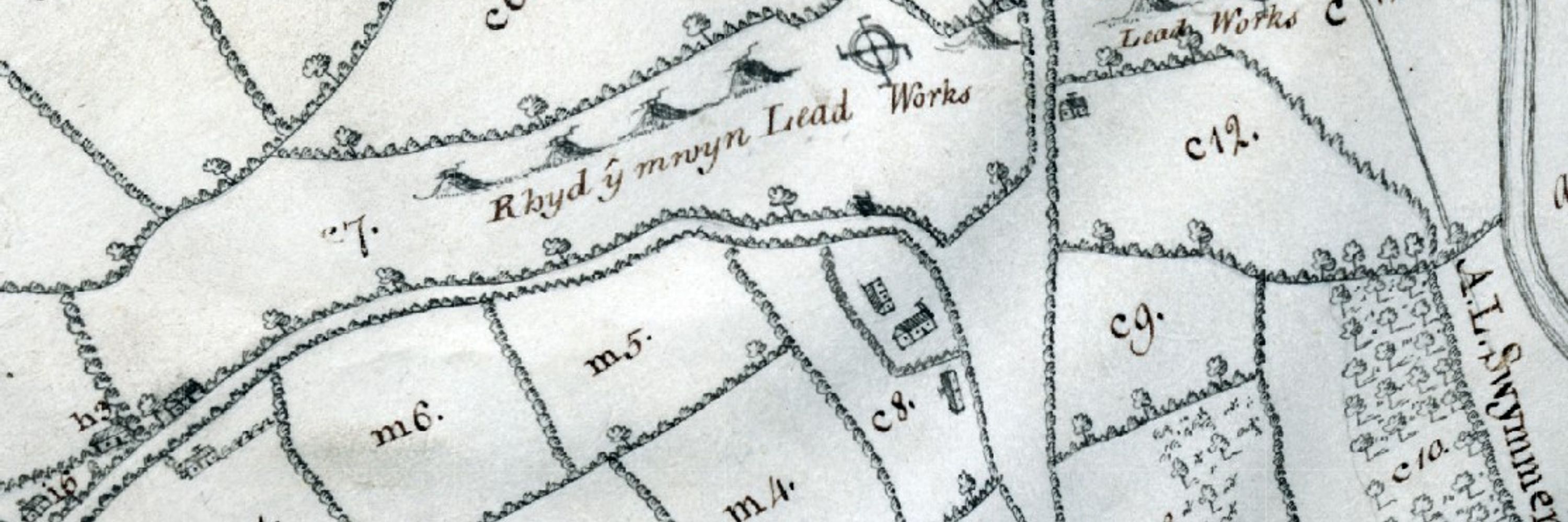
It's certainly been one of the most confusing places to map the boundaries for as you have a bit of Caernarfonshire surrounded by Denbighshire, surrounded by Carnarfonshire which is also surrounded by Denbighshire!!!
May 7, 2025 at 9:21 AM
It's certainly been one of the most confusing places to map the boundaries for as you have a bit of Caernarfonshire surrounded by Denbighshire, surrounded by Carnarfonshire which is also surrounded by Denbighshire!!!
Ah, that's strange as I'm using Chrome browser and it loads fine for me and people I've tested it with also using Chrome. The only thing I can think of is that your browser may be out of date? Here is the latest link: historical-boundaries-of-wales-rcahmw.hub.arcgis.com

Historical Boundaries of Wales
Discover, analyze and download data from Historical Boundaries of Wales. Download in CSV, KML, Zip, GeoJSON, GeoTIFF or PNG. Find API links for GeoServices, WMS, and WFS. Analyze with charts and thema...
historical-boundaries-of-wales-rcahmw.hub.arcgis.com
April 11, 2025 at 9:00 AM
Ah, that's strange as I'm using Chrome browser and it loads fine for me and people I've tested it with also using Chrome. The only thing I can think of is that your browser may be out of date? Here is the latest link: historical-boundaries-of-wales-rcahmw.hub.arcgis.com
Hi @davidelis-williams.bsky.social. I have been doing some updating today, but it should be working. Just a quick question, when you first open the web map, have you expanded the arrows next to each layer? These will reveal the specific layers that you can turn on and off by using the tick box.
April 10, 2025 at 4:02 PM
Hi @davidelis-williams.bsky.social. I have been doing some updating today, but it should be working. Just a quick question, when you first open the web map, have you expanded the arrows next to each layer? These will reveal the specific layers that you can turn on and off by using the tick box.
Ah, just checking as you made it to the licencing page, did you check the tick box? I've included a screen shot. If this box isn't checked it wont let you progress to the mapping.

November 28, 2024 at 1:08 PM
Ah, just checking as you made it to the licencing page, did you check the tick box? I've included a screen shot. If this box isn't checked it wont let you progress to the mapping.
Hi @hibiscus2586.bsky.social Sorry to hear that and thanks for letting me know. I'll have a poke around on the web mapping to see if there is a setting that is defaulted or if there is something I can change. Will keep you posted.
November 28, 2024 at 1:04 PM
Hi @hibiscus2586.bsky.social Sorry to hear that and thanks for letting me know. I'll have a poke around on the web mapping to see if there is a setting that is defaulted or if there is something I can change. Will keep you posted.
Hi @peterreavill.bsky.social. Depending upon the date of 1st Edition 25" OS, there may be mapping that overlap's into England or it may just go the county edge (much early mapping was mapped to the county boundary). Even then the overlap may not be significant. So it going to be pot luck I'm afraid
November 27, 2024 at 4:38 PM
Hi @peterreavill.bsky.social. Depending upon the date of 1st Edition 25" OS, there may be mapping that overlap's into England or it may just go the county edge (much early mapping was mapped to the county boundary). Even then the overlap may not be significant. So it going to be pot luck I'm afraid
I appreciate that & in time we may be able to make the mapping available under Open Government licence. Please do watch this space. Additionally, any digital (vector) datasets we create from these maps (such as historical boundaries) are made available under Open Gov Licence. Hope that helps.
November 27, 2024 at 4:02 PM
I appreciate that & in time we may be able to make the mapping available under Open Government licence. Please do watch this space. Additionally, any digital (vector) datasets we create from these maps (such as historical boundaries) are made available under Open Gov Licence. Hope that helps.
Hi Dai. The Anglesey mapping is a pilot project which we have made mapping available under the Non-Com Gov licence. You are able to copy, publish, distribute & transmit information & exploit the information for non-com purposes. This should cover anyone wanting to use this for an educational use.
November 27, 2024 at 3:56 PM
Hi Dai. The Anglesey mapping is a pilot project which we have made mapping available under the Non-Com Gov licence. You are able to copy, publish, distribute & transmit information & exploit the information for non-com purposes. This should cover anyone wanting to use this for an educational use.