


Jon Dollery
@jrdollery.bsky.social
Mapping Officer @rcahmwales.bsky.social | Landscape Archaeology | Historical GIS | Historical Cartography | FRGS | Board Game Enthusiast | Proud Cat Dad 🐱
👏📣🥁!!!JOB CLAXON ALERT!!!🥁📣👏
RCAHMW (@rcahmwales.bsky.social) are recruiting x2 Georeferencing Assistant Posts who will be working with yours truly to make some fantastic old maps publicly available. For more information, see the link below:
rcahmw.gov.uk/about-us/wor...
RCAHMW (@rcahmwales.bsky.social) are recruiting x2 Georeferencing Assistant Posts who will be working with yours truly to make some fantastic old maps publicly available. For more information, see the link below:
rcahmw.gov.uk/about-us/wor...
RCAHMW | Working for the Commission | Current Vacancies
rcahmw.gov.uk
June 24, 2025 at 10:14 AM
👏📣🥁!!!JOB CLAXON ALERT!!!🥁📣👏
RCAHMW (@rcahmwales.bsky.social) are recruiting x2 Georeferencing Assistant Posts who will be working with yours truly to make some fantastic old maps publicly available. For more information, see the link below:
rcahmw.gov.uk/about-us/wor...
RCAHMW (@rcahmwales.bsky.social) are recruiting x2 Georeferencing Assistant Posts who will be working with yours truly to make some fantastic old maps publicly available. For more information, see the link below:
rcahmw.gov.uk/about-us/wor...
Hello All. It's been a while since my last post as I've been working on several things. I've just completed the mapping of the medieval Commotes & Cantrefs of Wales which are now available on the Historical Boundaries of Wales website! historical-boundaries-of-wales-rcahmw.hub.arcgis.com

June 18, 2025 at 8:41 AM
Hello All. It's been a while since my last post as I've been working on several things. I've just completed the mapping of the medieval Commotes & Cantrefs of Wales which are now available on the Historical Boundaries of Wales website! historical-boundaries-of-wales-rcahmw.hub.arcgis.com
It's certainly been one of the most confusing places to map the boundaries for as you have a bit of Caernarfonshire surrounded by Denbighshire, surrounded by Carnarfonshire which is also surrounded by Denbighshire!!!
May 7, 2025 at 9:21 AM
It's certainly been one of the most confusing places to map the boundaries for as you have a bit of Caernarfonshire surrounded by Denbighshire, surrounded by Carnarfonshire which is also surrounded by Denbighshire!!!
Happy Friday Everyone! We've been working hard to recreate the historical townships of Wales from various historical sources and map.
The pre-1840 Township boundaries for Denbighshire, Flintshire, Montgomeryshire & Radnorshire are now available on the Historical Boundaries of Wales website!!!
The pre-1840 Township boundaries for Denbighshire, Flintshire, Montgomeryshire & Radnorshire are now available on the Historical Boundaries of Wales website!!!


April 25, 2025 at 9:35 AM
Happy Friday Everyone! We've been working hard to recreate the historical townships of Wales from various historical sources and map.
The pre-1840 Township boundaries for Denbighshire, Flintshire, Montgomeryshire & Radnorshire are now available on the Historical Boundaries of Wales website!!!
The pre-1840 Township boundaries for Denbighshire, Flintshire, Montgomeryshire & Radnorshire are now available on the Historical Boundaries of Wales website!!!
Happy Friday Everyone 🥳 Although I've been making some tweaks to the Historical Boundaries of Wales web map, I thought I'd have a play today with 3D web map, especially with the Anglesey 1st Edition 25inch OS Mapping with is available to view for free. Holyhead mountain in 1889 looks amazing in 3D!

April 11, 2025 at 9:10 AM
Happy Friday Everyone 🥳 Although I've been making some tweaks to the Historical Boundaries of Wales web map, I thought I'd have a play today with 3D web map, especially with the Anglesey 1st Edition 25inch OS Mapping with is available to view for free. Holyhead mountain in 1889 looks amazing in 3D!
Ah, that's strange as I'm using Chrome browser and it loads fine for me and people I've tested it with also using Chrome. The only thing I can think of is that your browser may be out of date? Here is the latest link: historical-boundaries-of-wales-rcahmw.hub.arcgis.com

Historical Boundaries of Wales
Discover, analyze and download data from Historical Boundaries of Wales. Download in CSV, KML, Zip, GeoJSON, GeoTIFF or PNG. Find API links for GeoServices, WMS, and WFS. Analyze with charts and thema...
historical-boundaries-of-wales-rcahmw.hub.arcgis.com
April 11, 2025 at 9:00 AM
Ah, that's strange as I'm using Chrome browser and it loads fine for me and people I've tested it with also using Chrome. The only thing I can think of is that your browser may be out of date? Here is the latest link: historical-boundaries-of-wales-rcahmw.hub.arcgis.com
Hi @davidelis-williams.bsky.social. I have been doing some updating today, but it should be working. Just a quick question, when you first open the web map, have you expanded the arrows next to each layer? These will reveal the specific layers that you can turn on and off by using the tick box.
April 10, 2025 at 4:02 PM
Hi @davidelis-williams.bsky.social. I have been doing some updating today, but it should be working. Just a quick question, when you first open the web map, have you expanded the arrows next to each layer? These will reveal the specific layers that you can turn on and off by using the tick box.
Hello All! I've been deliberately quiet for the past few months as I've been busily mapping historical boundaries of Wales from the 2nd Edition OS 6inch mapping (1889-1906). These are now live on the Historical Boundaries of Wales website! New boundaries include Civil Parishes & Poor Law Unions.

April 10, 2025 at 11:57 AM
Hello All! I've been deliberately quiet for the past few months as I've been busily mapping historical boundaries of Wales from the 2nd Edition OS 6inch mapping (1889-1906). These are now live on the Historical Boundaries of Wales website! New boundaries include Civil Parishes & Poor Law Unions.
Hello All.
Finally gotten over the backlog of e-mails and other bits and bobs. So today I can get back into the process of Georeferencing the 1st Edition 25" OS Maps, starting with the beautiful county of Flintshire. Haven't done this since Anglesey last year so looking forward to cracking on!
Finally gotten over the backlog of e-mails and other bits and bobs. So today I can get back into the process of Georeferencing the 1st Edition 25" OS Maps, starting with the beautiful county of Flintshire. Haven't done this since Anglesey last year so looking forward to cracking on!

January 15, 2025 at 1:12 PM
Hello All.
Finally gotten over the backlog of e-mails and other bits and bobs. So today I can get back into the process of Georeferencing the 1st Edition 25" OS Maps, starting with the beautiful county of Flintshire. Haven't done this since Anglesey last year so looking forward to cracking on!
Finally gotten over the backlog of e-mails and other bits and bobs. So today I can get back into the process of Georeferencing the 1st Edition 25" OS Maps, starting with the beautiful county of Flintshire. Haven't done this since Anglesey last year so looking forward to cracking on!
Happy New Year! Back in work today. #MapMonday, I thought I'd share an image of a GIS finding aid I've been working on for North Wales. Each dot represents a aerial photo taken by the @ordnancesurvey.bsky.social between 1970-2009. There are 61,662 points on this map!!! And this is only N. Wales!

January 13, 2025 at 3:15 PM
Happy New Year! Back in work today. #MapMonday, I thought I'd share an image of a GIS finding aid I've been working on for North Wales. Each dot represents a aerial photo taken by the @ordnancesurvey.bsky.social between 1970-2009. There are 61,662 points on this map!!! And this is only N. Wales!
Seasons Greetings from all the Staff at the Royal Commission who are out enjoying the festive mood this afternoon for our annual Christmas meal. Nadolig Llawen!
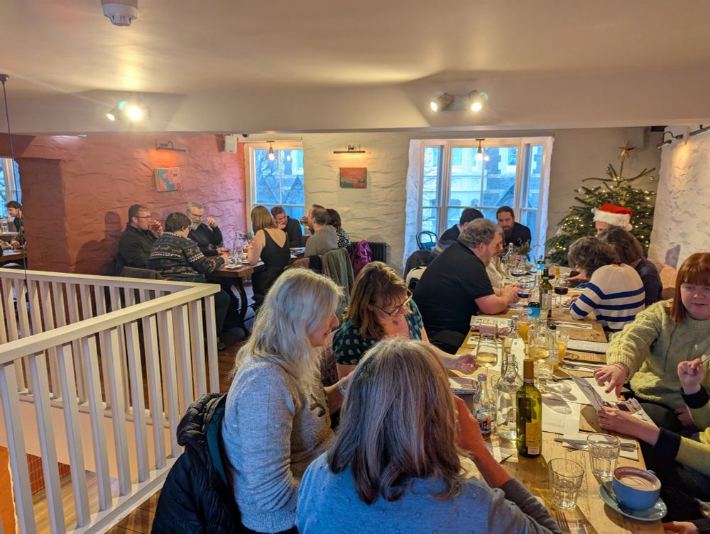
December 12, 2024 at 3:00 PM
Seasons Greetings from all the Staff at the Royal Commission who are out enjoying the festive mood this afternoon for our annual Christmas meal. Nadolig Llawen!
Out of the office today in sunny Bristol at the Engineers House with the @mappingthemarch.bsky.social @latemedievalist.bsky.social team for a workshop and our Advisory Board meeting. Very nice location for it.

December 6, 2024 at 10:47 AM
Out of the office today in sunny Bristol at the Engineers House with the @mappingthemarch.bsky.social @latemedievalist.bsky.social team for a workshop and our Advisory Board meeting. Very nice location for it.
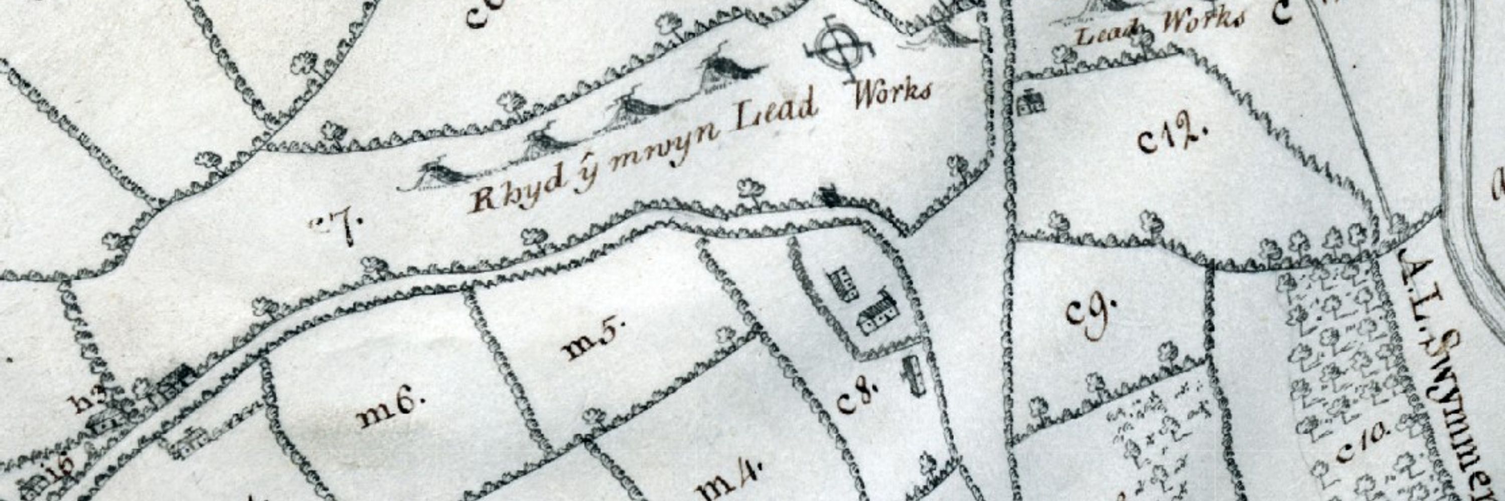
Hello All.
Just thought I'd share this screen shot from #DeepMappingEstateArchives webmap of the Thomas Badeslade map created in 1740 for the Duke of Westminster showing their landholdings of the uplands of Denbighshire. Love that there are 'old shafts' indicated on this map, how old are they!?
Just thought I'd share this screen shot from #DeepMappingEstateArchives webmap of the Thomas Badeslade map created in 1740 for the Duke of Westminster showing their landholdings of the uplands of Denbighshire. Love that there are 'old shafts' indicated on this map, how old are they!?

December 4, 2024 at 11:47 AM
Hello All.
Just thought I'd share this screen shot from #DeepMappingEstateArchives webmap of the Thomas Badeslade map created in 1740 for the Duke of Westminster showing their landholdings of the uplands of Denbighshire. Love that there are 'old shafts' indicated on this map, how old are they!?
Just thought I'd share this screen shot from #DeepMappingEstateArchives webmap of the Thomas Badeslade map created in 1740 for the Duke of Westminster showing their landholdings of the uplands of Denbighshire. Love that there are 'old shafts' indicated on this map, how old are they!?
It's #MapMonday!
Today I'd thought I'd share with you the nuggets that historical maps can give us about the past, antiquities & in this case gruesome discoveries. The OS Town Plan of Mold c.1871 gives details of 'Human Skeletons Found' near Mold Castle.
You can view this on Deep Mapping Website!
Today I'd thought I'd share with you the nuggets that historical maps can give us about the past, antiquities & in this case gruesome discoveries. The OS Town Plan of Mold c.1871 gives details of 'Human Skeletons Found' near Mold Castle.
You can view this on Deep Mapping Website!

December 2, 2024 at 11:08 AM
It's #MapMonday!
Today I'd thought I'd share with you the nuggets that historical maps can give us about the past, antiquities & in this case gruesome discoveries. The OS Town Plan of Mold c.1871 gives details of 'Human Skeletons Found' near Mold Castle.
You can view this on Deep Mapping Website!
Today I'd thought I'd share with you the nuggets that historical maps can give us about the past, antiquities & in this case gruesome discoveries. The OS Town Plan of Mold c.1871 gives details of 'Human Skeletons Found' near Mold Castle.
You can view this on Deep Mapping Website!
Something a bit different today.
I've been digitising the Ordnance Survey Aerial Imagery finding aids for Wales. I've been working on SJ (North Wales) & have done many sortie plots dating from 1970-2004. Only got a few more to do before finishing in 2009.
Each dot represents an Aerial Photo!
I've been digitising the Ordnance Survey Aerial Imagery finding aids for Wales. I've been working on SJ (North Wales) & have done many sortie plots dating from 1970-2004. Only got a few more to do before finishing in 2009.
Each dot represents an Aerial Photo!

November 28, 2024 at 1:20 PM
Something a bit different today.
I've been digitising the Ordnance Survey Aerial Imagery finding aids for Wales. I've been working on SJ (North Wales) & have done many sortie plots dating from 1970-2004. Only got a few more to do before finishing in 2009.
Each dot represents an Aerial Photo!
I've been digitising the Ordnance Survey Aerial Imagery finding aids for Wales. I've been working on SJ (North Wales) & have done many sortie plots dating from 1970-2004. Only got a few more to do before finishing in 2009.
Each dot represents an Aerial Photo!
Ah, just checking as you made it to the licencing page, did you check the tick box? I've included a screen shot. If this box isn't checked it wont let you progress to the mapping.

November 28, 2024 at 1:08 PM
Ah, just checking as you made it to the licencing page, did you check the tick box? I've included a screen shot. If this box isn't checked it wont let you progress to the mapping.
Hi @hibiscus2586.bsky.social Sorry to hear that and thanks for letting me know. I'll have a poke around on the web mapping to see if there is a setting that is defaulted or if there is something I can change. Will keep you posted.
November 28, 2024 at 1:04 PM
Hi @hibiscus2586.bsky.social Sorry to hear that and thanks for letting me know. I'll have a poke around on the web mapping to see if there is a setting that is defaulted or if there is something I can change. Will keep you posted.
Hi @peterreavill.bsky.social. Depending upon the date of 1st Edition 25" OS, there may be mapping that overlap's into England or it may just go the county edge (much early mapping was mapped to the county boundary). Even then the overlap may not be significant. So it going to be pot luck I'm afraid
November 27, 2024 at 4:38 PM
Hi @peterreavill.bsky.social. Depending upon the date of 1st Edition 25" OS, there may be mapping that overlap's into England or it may just go the county edge (much early mapping was mapped to the county boundary). Even then the overlap may not be significant. So it going to be pot luck I'm afraid
I appreciate that & in time we may be able to make the mapping available under Open Government licence. Please do watch this space. Additionally, any digital (vector) datasets we create from these maps (such as historical boundaries) are made available under Open Gov Licence. Hope that helps.
November 27, 2024 at 4:02 PM
I appreciate that & in time we may be able to make the mapping available under Open Government licence. Please do watch this space. Additionally, any digital (vector) datasets we create from these maps (such as historical boundaries) are made available under Open Gov Licence. Hope that helps.
Hi Dai. The Anglesey mapping is a pilot project which we have made mapping available under the Non-Com Gov licence. You are able to copy, publish, distribute & transmit information & exploit the information for non-com purposes. This should cover anyone wanting to use this for an educational use.
November 27, 2024 at 3:56 PM
Hi Dai. The Anglesey mapping is a pilot project which we have made mapping available under the Non-Com Gov licence. You are able to copy, publish, distribute & transmit information & exploit the information for non-com purposes. This should cover anyone wanting to use this for an educational use.
The Royal Commission has funded the National Library of Wales to scan all of it's 1st Edition 25" OS mapping. The plan in the new year is to begin georeferencing them & make them freely available. We have made a start with Anglesey which you can view here:
rcahmw.maps.arcgis.com/apps/webappv...
rcahmw.maps.arcgis.com/apps/webappv...

November 27, 2024 at 11:47 AM
The Royal Commission has funded the National Library of Wales to scan all of it's 1st Edition 25" OS mapping. The plan in the new year is to begin georeferencing them & make them freely available. We have made a start with Anglesey which you can view here:
rcahmw.maps.arcgis.com/apps/webappv...
rcahmw.maps.arcgis.com/apps/webappv...
Shwmae All!
Continuing my quest to share some mapping info with you I thought I'd share our customer success story about the
#DeepMapping project that was produced by @EsriUK a few weeks ago. It's a great read & sums up everything about the project.
resource.esriuk.com/esri-resourc...
Continuing my quest to share some mapping info with you I thought I'd share our customer success story about the
#DeepMapping project that was produced by @EsriUK a few weeks ago. It's a great read & sums up everything about the project.
resource.esriuk.com/esri-resourc...

November 26, 2024 at 2:03 PM
Shwmae All!
Continuing my quest to share some mapping info with you I thought I'd share our customer success story about the
#DeepMapping project that was produced by @EsriUK a few weeks ago. It's a great read & sums up everything about the project.
resource.esriuk.com/esri-resourc...
Continuing my quest to share some mapping info with you I thought I'd share our customer success story about the
#DeepMapping project that was produced by @EsriUK a few weeks ago. It's a great read & sums up everything about the project.
resource.esriuk.com/esri-resourc...
It's #MapMonday! I thought I'd reshare the link to the Historical Boundaries of Wales website which launched a few weeks ago. Here you can explore a variety of 19th century boundaries such as Hundreds, Parishes, Townships & Municipal Wards.
historical-boundaries-of-wales-rcahmw.hub.arcgis.com
historical-boundaries-of-wales-rcahmw.hub.arcgis.com
Historical Boundaries of Wales
Discover, analyze and download data from Historical Boundaries of Wales. Download in CSV, KML, Zip, GeoJSON, GeoTIFF or PNG. Find API links for GeoServices, WMS, and WFS. Analyze with charts and thema...
historical-boundaries-of-wales-rcahmw.hub.arcgis.com
November 25, 2024 at 11:45 AM
It's #MapMonday! I thought I'd reshare the link to the Historical Boundaries of Wales website which launched a few weeks ago. Here you can explore a variety of 19th century boundaries such as Hundreds, Parishes, Townships & Municipal Wards.
historical-boundaries-of-wales-rcahmw.hub.arcgis.com
historical-boundaries-of-wales-rcahmw.hub.arcgis.com
Hello All.
Just thought I'd share a link for blog I wrote for Royal Commission Wales about the Launching of the Historical Boundaries of Wales website. This outlines the need / challenges of mapping historical boundaries from the 19th Century. Please do have a read.
rcahmw.gov.uk/launch-of-th...
Just thought I'd share a link for blog I wrote for Royal Commission Wales about the Launching of the Historical Boundaries of Wales website. This outlines the need / challenges of mapping historical boundaries from the 19th Century. Please do have a read.
rcahmw.gov.uk/launch-of-th...
RCAHMW | Launch of the Historical Boundaries of Wales website
rcahmw.gov.uk
November 23, 2024 at 8:31 AM
Hello All.
Just thought I'd share a link for blog I wrote for Royal Commission Wales about the Launching of the Historical Boundaries of Wales website. This outlines the need / challenges of mapping historical boundaries from the 19th Century. Please do have a read.
rcahmw.gov.uk/launch-of-th...
Just thought I'd share a link for blog I wrote for Royal Commission Wales about the Launching of the Historical Boundaries of Wales website. This outlines the need / challenges of mapping historical boundaries from the 19th Century. Please do have a read.
rcahmw.gov.uk/launch-of-th...
Hello All.
Hope you are all well on this Friday and looking forward to the Weekend.
Just thought I'd share with you that the #DeepMappingEstateArchives web mapping has been updated and now includes 3D mapping!!! You can explore the mapping here: deep-mapping-estate-archives-rcahmw.hub.arcgis.com
Hope you are all well on this Friday and looking forward to the Weekend.
Just thought I'd share with you that the #DeepMappingEstateArchives web mapping has been updated and now includes 3D mapping!!! You can explore the mapping here: deep-mapping-estate-archives-rcahmw.hub.arcgis.com


November 22, 2024 at 1:15 PM
Hello All.
Hope you are all well on this Friday and looking forward to the Weekend.
Just thought I'd share with you that the #DeepMappingEstateArchives web mapping has been updated and now includes 3D mapping!!! You can explore the mapping here: deep-mapping-estate-archives-rcahmw.hub.arcgis.com
Hope you are all well on this Friday and looking forward to the Weekend.
Just thought I'd share with you that the #DeepMappingEstateArchives web mapping has been updated and now includes 3D mapping!!! You can explore the mapping here: deep-mapping-estate-archives-rcahmw.hub.arcgis.com