


Recently I stumbled upon the web serial api! Supported in Chromium browsers, it allows you to hook into a devices attached to serial ports on your machine through the browser! I've implemented logic to read in a gps nmea stream directly into our SIIS web app!
November 11, 2025 at 1:15 PM
Recently I stumbled upon the web serial api! Supported in Chromium browsers, it allows you to hook into a devices attached to serial ports on your machine through the browser! I've implemented logic to read in a gps nmea stream directly into our SIIS web app!
More timelines! Two way interaction between our custom Imagery Collection Layer and the timeline! #timelines #arcgisdev
October 31, 2025 at 4:02 PM
More timelines! Two way interaction between our custom Imagery Collection Layer and the timeline! #timelines #arcgisdev
Working on adding some timeline user interface components to simplify the process of choosing relevant data. In this case we a bring COGs directly into the app from a STAC api! #arcgisdev
October 29, 2025 at 4:25 PM
Working on adding some timeline user interface components to simplify the process of choosing relevant data. In this case we a bring COGs directly into the app from a STAC api! #arcgisdev
Building a timeline using d3.js. Sometimes its easier to roll your own then search for that golden goose library that someone else has built! Pretty much unstyled at the moment, but has the functionality I need for handling interactions.
October 1, 2025 at 4:31 PM
Building a timeline using d3.js. Sometimes its easier to roll your own then search for that golden goose library that someone else has built! Pretty much unstyled at the moment, but has the functionality I need for handling interactions.
Whilst updating an app to the latest version of the ArcGIS JS API (4.33) we picked up a minor regression in labelling for a super niche situation. I would call that one epic win for our automated testing setup! Check out our setup here: github.com/antarctica/e... #Arcgis #Dev #Playwright
July 3, 2025 at 5:11 PM
Whilst updating an app to the latest version of the ArcGIS JS API (4.33) we picked up a minor regression in labelling for a super niche situation. I would call that one epic win for our automated testing setup! Check out our setup here: github.com/antarctica/e... #Arcgis #Dev #Playwright
I always like to get in early with implementing a responsive UI - usually it means that the actual extra code is pretty minimal! #arcgis #responsive
June 25, 2025 at 3:02 PM
I always like to get in early with implementing a responsive UI - usually it means that the actual extra code is pretty minimal! #arcgis #responsive
Ever wondered how to do snapshot end-to-end testing when you have live map data? If you are using Playwright you can try capturing the HAR traffic and replaying this when the tests are rerun: playwright.dev/docs/mock#mo.... We use this with ArcGIS where it wouldn't be possible to mock .pbf responses

March 28, 2025 at 2:23 PM
Ever wondered how to do snapshot end-to-end testing when you have live map data? If you are using Playwright you can try capturing the HAR traffic and replaying this when the tests are rerun: playwright.dev/docs/mock#mo.... We use this with ArcGIS where it wouldn't be possible to mock .pbf responses
Steal this implementation of a Labelled Graticule Layer for you arcgis apps. It utilises a client side feature layer and the new display filter to control which lines/labels to show. It works for any projection. gist.github.com/JonnyDawe/be... #arcgis #arcgisjs

March 26, 2025 at 1:21 PM
Steal this implementation of a Labelled Graticule Layer for you arcgis apps. It utilises a client side feature layer and the new display filter to control which lines/labels to show. It works for any projection. gist.github.com/JonnyDawe/be... #arcgis #arcgisjs
New workflows for adding points in different formats (DDM, DD, DMS etc.) We've implemented a custom graphics layer which persists graphics in local storage - check it out here: gist.github.com/JonnyDawe/8d.... #arcgis #arcgisJS
March 25, 2025 at 11:50 AM
New workflows for adding points in different formats (DDM, DD, DMS etc.) We've implemented a custom graphics layer which persists graphics in local storage - check it out here: gist.github.com/JonnyDawe/8d.... #arcgis #arcgisJS
How would you alert a user to new data being available into a long running application? I've been building a simple notification and synchronise workflow for our Sea Ice Information application that could be up on a ship's bridge running for days.
March 11, 2025 at 5:14 PM
How would you alert a user to new data being available into a long running application? I've been building a simple notification and synchronise workflow for our Sea Ice Information application that could be up on a ship's bridge running for days.
Revisiting my measurements interaction in our ArcGIS JS application - added in some simple logic to remove text that is longer than the segment length. All just subclassed from the Esri Measurements Sketch View Model! #ArcGIS #ArcGISJSAPI
March 7, 2025 at 4:42 PM
Revisiting my measurements interaction in our ArcGIS JS application - added in some simple logic to remove text that is longer than the segment length. All just subclassed from the Esri Measurements Sketch View Model! #ArcGIS #ArcGISJSAPI
Sooo many gems in this release! Map components now work perfectly with React - including jsx types coming through. The general typescript changes are such a great improvement on DX. The new geometry operators continue to delight me - already found a use for shape-preserving projection. Great Job!

February 25, 2025 at 5:10 PM
Sooo many gems in this release! Map components now work perfectly with React - including jsx types coming through. The general typescript changes are such a great improvement on DX. The new geometry operators continue to delight me - already found a use for shape-preserving projection. Great Job!
We use Playwright for end-to-end testing our ArcGIS Applications. This includes some screenshot testing in our CICD process. It was pretty fiddly to get working, has already been catching bugs we weren't even aware off! Check it out here: github.com/antarctica/e... #Arcgis #ArcGISDev
February 25, 2025 at 4:50 PM
We use Playwright for end-to-end testing our ArcGIS Applications. This includes some screenshot testing in our CICD process. It was pretty fiddly to get working, has already been catching bugs we weren't even aware off! Check it out here: github.com/antarctica/e... #Arcgis #ArcGISDev
Especially in the South West…

January 26, 2025 at 5:30 PM
Especially in the South West…
Sometimes you have to take joy in the small things... For example watching the dev console fill up because some dependency left a console.log("here") in their library code! 🫣

January 17, 2025 at 12:57 PM
Sometimes you have to take joy in the small things... For example watching the dev console fill up because some dependency left a console.log("here") in their library code! 🫣
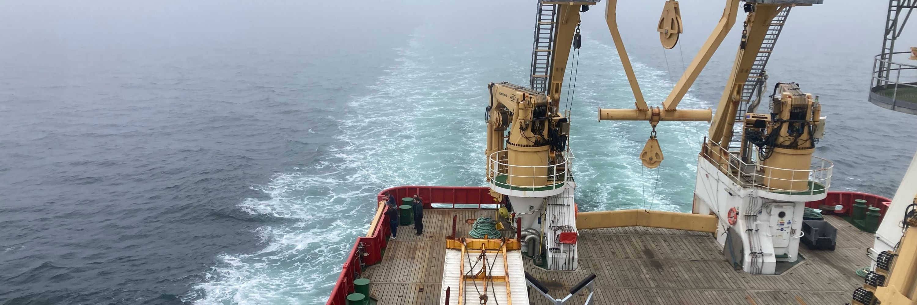
Just shipped a new mapping application to a literal ship – the RRS Sir David Attenborough 🚢! Super proud of the collaborative effort that came together to make this happen at the British Antarctic Survey!
December 20, 2024 at 11:27 AM
Just shipped a new mapping application to a literal ship – the RRS Sir David Attenborough 🚢! Super proud of the collaborative effort that came together to make this happen at the British Antarctic Survey!
Refactored some line measurement controls. I took the approach of extending the Esri Sketchviewmodel with extra labelling functionality loosely based off logic from this blog: www.esri.com/arcgis-blog/.... (Albeit I am not using an arcade profile anymore!). #ArcGIS #MapDev
December 18, 2024 at 3:26 PM
Refactored some line measurement controls. I took the approach of extending the Esri Sketchviewmodel with extra labelling functionality loosely based off logic from this blog: www.esri.com/arcgis-blog/.... (Albeit I am not using an arcade profile anymore!). #ArcGIS #MapDev
Always a nice touch being able to add your application to be launched from the user's homescreen!
December 13, 2024 at 10:57 AM
Always a nice touch being able to add your application to be launched from the user's homescreen!
I'm a strong proponent of making mapping applications work seamlessly across all screen sizes. I'm yet to experience an application which has not had at least equal usage across mobile/desktop devices. If you ignore mobile, you ignore half your user base...
December 9, 2024 at 12:24 PM
I'm a strong proponent of making mapping applications work seamlessly across all screen sizes. I'm yet to experience an application which has not had at least equal usage across mobile/desktop devices. If you ignore mobile, you ignore half your user base...
Building up a neat little editing workflow by directly plugging into the ArcGIS SketchView Model in the JS API. The trickiest bit has been getting the user interface nice and "React-ive", I'll try and get a snippet shared soon! #arcgis
December 6, 2024 at 4:25 PM
Building up a neat little editing workflow by directly plugging into the ArcGIS SketchView Model in the JS API. The trickiest bit has been getting the user interface nice and "React-ive", I'll try and get a snippet shared soon! #arcgis
Adding a visual timeline interface to map layer controls is a game-changer for exploring the temporal dimension of your data! 🗺️⏳ I built this one with @visjs: visjs.org
December 4, 2024 at 1:28 PM
Adding a visual timeline interface to map layer controls is a game-changer for exploring the temporal dimension of your data! 🗺️⏳ I built this one with @visjs: visjs.org
Really happy with how dark mode / light mode toggling has turned out. I've fully embraced Panda CSS, which makes creating semantic color tokens crazy simple. #PandaCSS
November 29, 2024 at 4:28 PM
Really happy with how dark mode / light mode toggling has turned out. I've fully embraced Panda CSS, which makes creating semantic color tokens crazy simple. #PandaCSS
