


Jonas Oesch
@jonasoesch.ch
Visual journalist at @visuals.nzz.ch
Personal: jonasoesch.ch
Personal: jonasoesch.ch
Maybe it will be in a few years – but for now it has been just another set of tools. So, "use AI" would feel like telling people to use Figma instead of Photoshop to design interactives.
August 29, 2025 at 8:18 AM
Maybe it will be in a few years – but for now it has been just another set of tools. So, "use AI" would feel like telling people to use Figma instead of Photoshop to design interactives.
"Recognizing these historical parallels can point to potential future developments […] we can comment on something that statistical graphics can learn from comics, which is how to add some structure to the viewing experience." 2/2
August 15, 2025 at 12:38 PM
"Recognizing these historical parallels can point to potential future developments […] we can comment on something that statistical graphics can learn from comics, which is how to add some structure to the viewing experience." 2/2
No, you didn't miss anything. We haven't tested different orders. Would be very interesting to see if it has an influence.
July 4, 2025 at 2:45 PM
No, you didn't miss anything. We haven't tested different orders. Would be very interesting to see if it has an influence.
+1 for Readwise Reader. For notes I have been with Bear.app since 2017 and I still enjoy it.

Bear
Bear is a beautiful, powerfully simple Markdown note taking app to capture, write, and organize your life.
Bear.app
May 26, 2025 at 9:25 AM
+1 for Readwise Reader. For notes I have been with Bear.app since 2017 and I still enjoy it.
That was one of our favorites too! The split hemispheres/-continents allowed us to show the continents even slightly larger – so we went with them.
May 19, 2025 at 6:32 AM
That was one of our favorites too! The split hemispheres/-continents allowed us to show the continents even slightly larger – so we went with them.
I can totally relate. We took pretty long to come up with the split-hemispheres. In hindsight it is so obvious 😅
May 16, 2025 at 3:59 PM
I can totally relate. We took pretty long to come up with the split-hemispheres. In hindsight it is so obvious 😅
Ah, these are interesting! What’s the egg-shaped projection called? We explored the two-globe version too (Figure 4), but the split hemispheres/continents were more space-efficient.
www.tandfonline.com/doi/figure/1...
www.tandfonline.com/doi/figure/1...
www.tandfonline.com
May 16, 2025 at 3:55 PM
Ah, these are interesting! What’s the egg-shaped projection called? We explored the two-globe version too (Figure 4), but the split hemispheres/continents were more space-efficient.
www.tandfonline.com/doi/figure/1...
www.tandfonline.com/doi/figure/1...
Reposted by Jonas Oesch
Very nice!
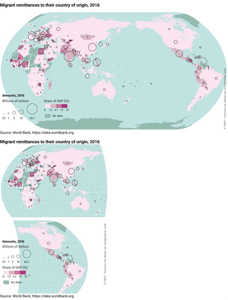
A few years back we faced the same problem and tried different solutions.
From using a different projection to cutting the map and even rotating it.
espace-mondial-atlas.sciencespo.fr/en/topic-res...
A few years back we faced the same problem and tried different solutions.
From using a different projection to cutting the map and even rotating it.
espace-mondial-atlas.sciencespo.fr/en/topic-res...


April 28, 2025 at 9:39 AM
Very nice!
A few years back we faced the same problem and tried different solutions.
From using a different projection to cutting the map and even rotating it.
espace-mondial-atlas.sciencespo.fr/en/topic-res...
A few years back we faced the same problem and tried different solutions.
From using a different projection to cutting the map and even rotating it.
espace-mondial-atlas.sciencespo.fr/en/topic-res...
Thanks for the examples, Lisa. I hadn’t seen these! We actually tried the rotated map (Figure 4), but it made us feel dizzy pretty quickly, so we abandoned it :-)
www.tandfonline.com/doi/figure/1...
www.tandfonline.com/doi/figure/1...
Figures & data: Thematic World Maps in the News: How Effective are They on Smartphones?
Figures and data for Thematic World Maps in the News: How Effective are They on Smartphones?
www.tandfonline.com
May 16, 2025 at 3:48 PM
Thanks for the examples, Lisa. I hadn’t seen these! We actually tried the rotated map (Figure 4), but it made us feel dizzy pretty quickly, so we abandoned it :-)
www.tandfonline.com/doi/figure/1...
www.tandfonline.com/doi/figure/1...
Full paper here → www.tandfonline.com/doi/full/10....
Big thanks to @sarahschoettler.com & @arzucoltekin.bsky.social for for helping write up the paper. 3/3
Big thanks to @sarahschoettler.com & @arzucoltekin.bsky.social for for helping write up the paper. 3/3
Thematic World Maps in the News: How Effective are They on Smartphones?
Thematic world maps are commonly used in online news media, but rarely optimized for mobile devices. Scaling down world maps to fit small screens makes many smaller countries difficult to identify,...
www.tandfonline.com
May 14, 2025 at 9:38 AM
Full paper here → www.tandfonline.com/doi/full/10....
Big thanks to @sarahschoettler.com & @arzucoltekin.bsky.social for for helping write up the paper. 3/3
Big thanks to @sarahschoettler.com & @arzucoltekin.bsky.social for for helping write up the paper. 3/3
We found:
• Splitting and resizing continents makes small countries easier to spot – and is still readable
• Bubble maps are more accurate – but people really don’t like them 2/3
• Splitting and resizing continents makes small countries easier to spot – and is still readable
• Bubble maps are more accurate – but people really don’t like them 2/3
May 14, 2025 at 9:38 AM
We found:
• Splitting and resizing continents makes small countries easier to spot – and is still readable
• Bubble maps are more accurate – but people really don’t like them 2/3
• Splitting and resizing continents makes small countries easier to spot – and is still readable
• Bubble maps are more accurate – but people really don’t like them 2/3