


Julien C
@jjcwpg.bsky.social
Meteorologist instructor and local climate specialist. Posts my own. Winnipeg MB
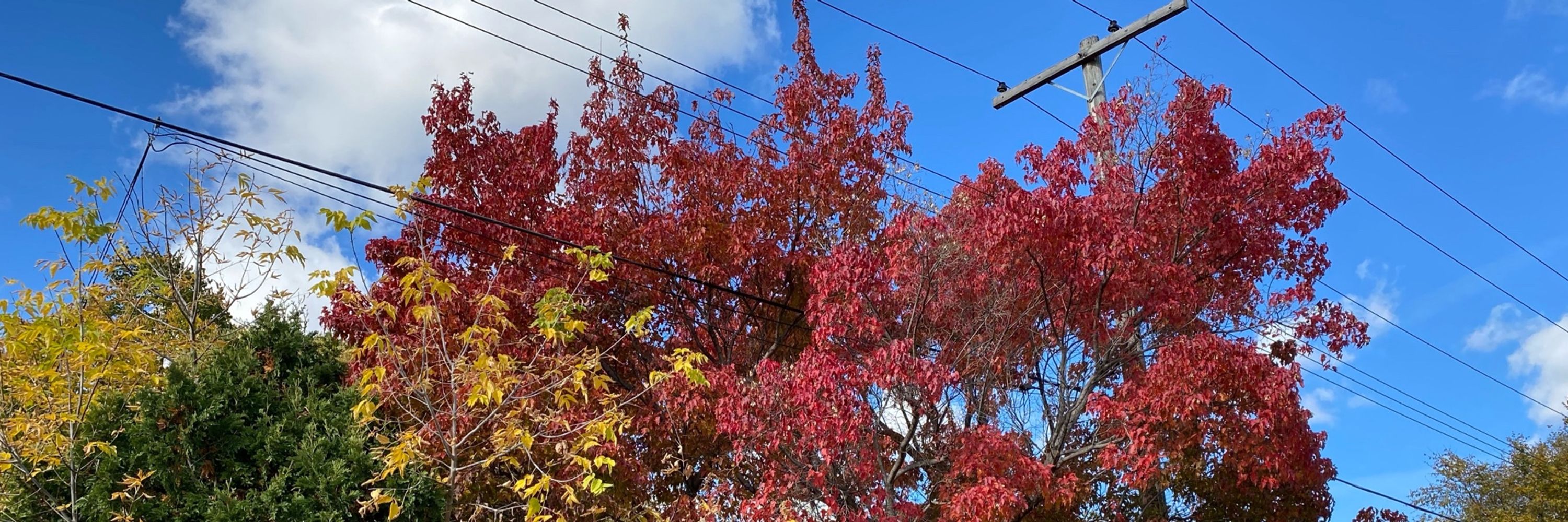
The HIGH of 9.0°C in Winnipeg yesterday not only broke the daily record of 10.6 in 1889, it was the earliest single digit high on record since records began in 1872. It was the only single digit high ever recorded between June 9 and September 6.
September 5, 2025 at 12:42 PM
The HIGH of 9.0°C in Winnipeg yesterday not only broke the daily record of 10.6 in 1889, it was the earliest single digit high on record since records began in 1872. It was the only single digit high ever recorded between June 9 and September 6.
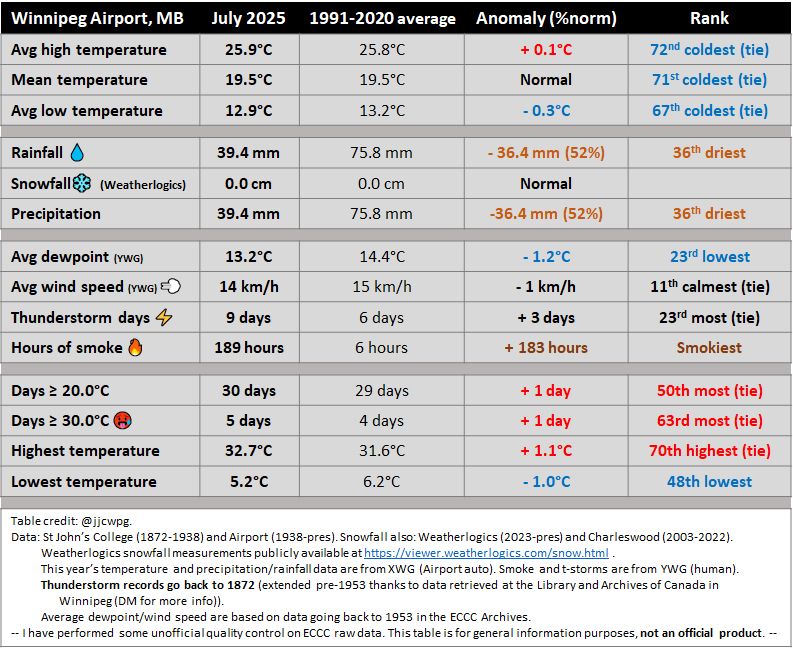
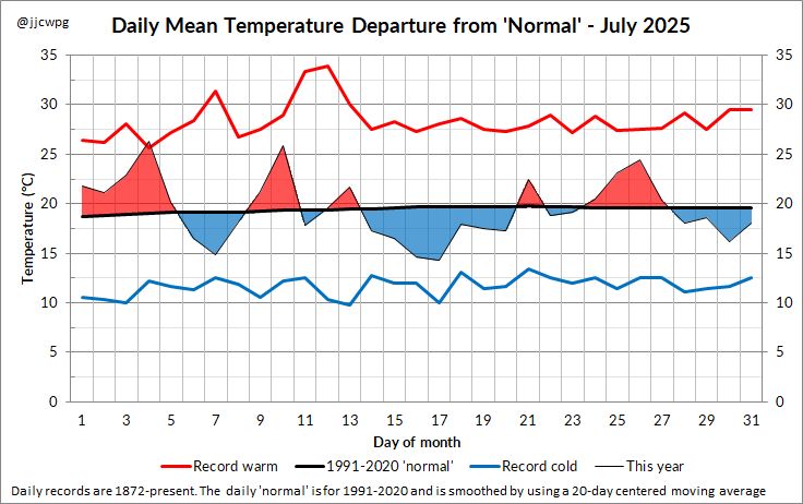
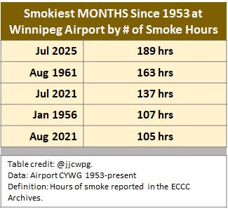
July was the smokiest month on record in Winnipeg with 189 hours of smoke at the Airport. Temperatures were average, but it was much drier than normal.
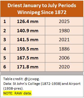
It was also the driest January to July on record at the Airport with 126mm of precip. Normal is close to 300mm
It was also the driest January to July on record at the Airport with 126mm of precip. Normal is close to 300mm
August 1, 2025 at 1:01 PM
July was the smokiest month on record in Winnipeg with 189 hours of smoke at the Airport. Temperatures were average, but it was much drier than normal.
It was also the driest January to July on record at the Airport with 126mm of precip. Normal is close to 300mm
It was also the driest January to July on record at the Airport with 126mm of precip. Normal is close to 300mm
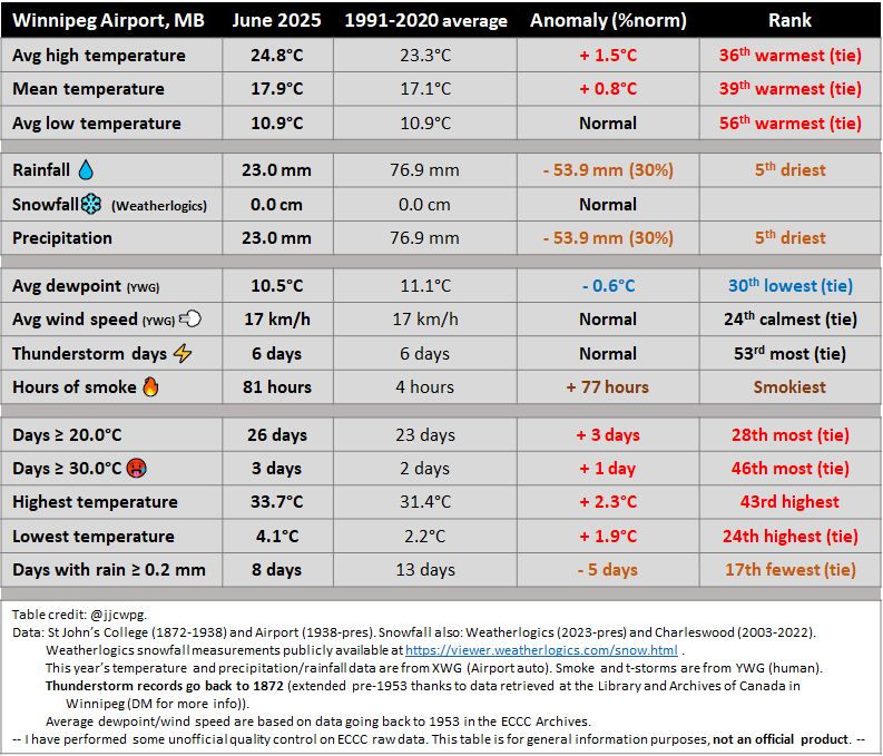
June was very dry and historically smoky in Winnipeg. 81 hours of smoke at the Airport was easily a record since 1953. Rainfall varied from 20 mm in western parts of the city to 60 mm in eastern parts, but the 23 mm at the Airport was the driest in over 50 years (since 1974).


July 1, 2025 at 8:27 PM
June was very dry and historically smoky in Winnipeg. 81 hours of smoke at the Airport was easily a record since 1953. Rainfall varied from 20 mm in western parts of the city to 60 mm in eastern parts, but the 23 mm at the Airport was the driest in over 50 years (since 1974).
We're only 6 days into June, but it's already the smokiest June on record since 1953 in Winnipeg. 58 hours of smoke and counting as of 6am this morning.


June 6, 2025 at 11:42 AM
We're only 6 days into June, but it's already the smokiest June on record since 1953 in Winnipeg. 58 hours of smoke and counting as of 6am this morning.
It was the 6th warmest May since 1872 in Winnipeg with a mean temperature of 14.7°C, 3.6°C above normal. Note we just had the 2nd warmest May two years ago in 2023.
Measurable rain fell on only 3 days, the fewest in over a century. It was also the 3rd consecutive May to be in the top 5 smokiest.
Measurable rain fell on only 3 days, the fewest in over a century. It was also the 3rd consecutive May to be in the top 5 smokiest.


June 1, 2025 at 10:51 PM
It was the 6th warmest May since 1872 in Winnipeg with a mean temperature of 14.7°C, 3.6°C above normal. Note we just had the 2nd warmest May two years ago in 2023.
Measurable rain fell on only 3 days, the fewest in over a century. It was also the 3rd consecutive May to be in the top 5 smokiest.
Measurable rain fell on only 3 days, the fewest in over a century. It was also the 3rd consecutive May to be in the top 5 smokiest.
It was the warmest first two weeks of May on record in Winnipeg since 1872, beating 1977. This was the case for both mean temperature and average daily high temperature.
Note that the month overall won't be nearly as impressive due to colder weather starting tomorrow.
Note that the month overall won't be nearly as impressive due to colder weather starting tomorrow.


May 15, 2025 at 2:04 PM
It was the warmest first two weeks of May on record in Winnipeg since 1872, beating 1977. This was the case for both mean temperature and average daily high temperature.
Note that the month overall won't be nearly as impressive due to colder weather starting tomorrow.
Note that the month overall won't be nearly as impressive due to colder weather starting tomorrow.
Incredible temperatures in the Red River Valley and Interlake yesterday... Reaching almost 38°C at some stations. Winnipeg's 37.0°C was the earliest 37°C, beating May 22, 1980.
May 14, 2025 at 12:09 PM
Incredible temperatures in the Red River Valley and Interlake yesterday... Reaching almost 38°C at some stations. Winnipeg's 37.0°C was the earliest 37°C, beating May 22, 1980.
A very average April in Winnipeg, but dry. Less than half the normal precipitation fell. If April felt warm, it was only because we had so many cold ones in the past decade that we've forgotten what's normal.


May 1, 2025 at 12:01 PM
A very average April in Winnipeg, but dry. Less than half the normal precipitation fell. If April felt warm, it was only because we had so many cold ones in the past decade that we've forgotten what's normal.
A mild March overall in Winnipeg with average snowfall. Most of the winter snow pack was gone by mid March.
Note that the Weatherlogics snow measurement site is in southwestern parts of the city where amounts were lower in last week's event. North and east parts of the city received over 20 cm.
Note that the Weatherlogics snow measurement site is in southwestern parts of the city where amounts were lower in last week's event. North and east parts of the city received over 20 cm.


April 1, 2025 at 12:16 PM
A mild March overall in Winnipeg with average snowfall. Most of the winter snow pack was gone by mid March.
Note that the Weatherlogics snow measurement site is in southwestern parts of the city where amounts were lower in last week's event. North and east parts of the city received over 20 cm.
Note that the Weatherlogics snow measurement site is in southwestern parts of the city where amounts were lower in last week's event. North and east parts of the city received over 20 cm.


It was generally another mild meteorological winter in Winnipeg, but much colder than last year. The worst cold snap was in February. Snowfall was around normal, but most of it fell in December. It was also windier than normal, tied 6th windiest winter since 1953.


March 1, 2025 at 4:32 PM
It was generally another mild meteorological winter in Winnipeg, but much colder than last year. The worst cold snap was in February. Snowfall was around normal, but most of it fell in December. It was also windier than normal, tied 6th windiest winter since 1953.
At almost 2 degrees below normal, February was the most colder than normal month since April 2023 in Winnipeg, which shows the impressive warm streak we've had the past couple years. It was also the coldest month in 3 years, since February 2022.
February was also very dry with half the normal snow.
February was also very dry with half the normal snow.


March 1, 2025 at 4:09 PM
At almost 2 degrees below normal, February was the most colder than normal month since April 2023 in Winnipeg, which shows the impressive warm streak we've had the past couple years. It was also the coldest month in 3 years, since February 2022.
February was also very dry with half the normal snow.
February was also very dry with half the normal snow.
January was a roller coaster ride of temperatures in Winnipeg, but was very average by 21st century norms. However, it was the first time since 1872 that we had two consecutive Januarys with one or fewer days below -30°C. There were far more days below -30°C in southwestern Manitoba (9 in Brandon).


February 1, 2025 at 3:17 PM
January was a roller coaster ride of temperatures in Winnipeg, but was very average by 21st century norms. However, it was the first time since 1872 that we had two consecutive Januarys with one or fewer days below -30°C. There were far more days below -30°C in southwestern Manitoba (9 in Brandon).
With a high of 3.4c at Winnipeg airport earlier this afternoon, we just squeezed in a record high for today breaking 3.3C in 1976. Cold front from the north has already dropped us below freezing.
January 28, 2025 at 9:35 PM
With a high of 3.4c at Winnipeg airport earlier this afternoon, we just squeezed in a record high for today breaking 3.3C in 1976. Cold front from the north has already dropped us below freezing.
Those were quite some winds in southern Manitoba yesterday... Widespread gusts of 90 to 100 km/h through south-central Manitoba. Winnipeg Airport gusted to 87 km/h, the strongest gust in January since 2009 (though 85 km/h was recorded during a blizzard on Jan 12, 2017)


January 18, 2025 at 6:47 PM
Those were quite some winds in southern Manitoba yesterday... Widespread gusts of 90 to 100 km/h through south-central Manitoba. Winnipeg Airport gusted to 87 km/h, the strongest gust in January since 2009 (though 85 km/h was recorded during a blizzard on Jan 12, 2017)
Welcome to 2025!
2024 was an exceptionally warm year in southern Mb. In Winnipeg, the 2nd warmest since 1872 & warmest since 1987
Cold was distinctly infrequent with the number of -10c and -20c days being nearly a month less than average. It was also the foggiest year since 2001
2024 was an exceptionally warm year in southern Mb. In Winnipeg, the 2nd warmest since 1872 & warmest since 1987
Cold was distinctly infrequent with the number of -10c and -20c days being nearly a month less than average. It was also the foggiest year since 2001


January 1, 2025 at 7:21 PM
Welcome to 2025!
2024 was an exceptionally warm year in southern Mb. In Winnipeg, the 2nd warmest since 1872 & warmest since 1987
Cold was distinctly infrequent with the number of -10c and -20c days being nearly a month less than average. It was also the foggiest year since 2001
2024 was an exceptionally warm year in southern Mb. In Winnipeg, the 2nd warmest since 1872 & warmest since 1987
Cold was distinctly infrequent with the number of -10c and -20c days being nearly a month less than average. It was also the foggiest year since 2001
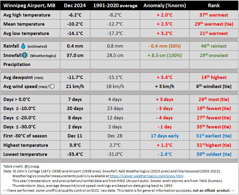
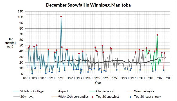
It was a mild, snowy, foggy & windy December in Winnipeg.
-Windiest since 2016.
-6 days had freezing drizzle (most since 2005) and 6 days had fog. Normal only 2 days for each
-Overall, it was a roller coaster ride for temperatures with some wild ups and downs.
-Warmest Dec 27
-Windiest since 2016.
-6 days had freezing drizzle (most since 2005) and 6 days had fog. Normal only 2 days for each
-Overall, it was a roller coaster ride for temperatures with some wild ups and downs.
-Warmest Dec 27


January 1, 2025 at 7:17 PM
It was a mild, snowy, foggy & windy December in Winnipeg.
-Windiest since 2016.
-6 days had freezing drizzle (most since 2005) and 6 days had fog. Normal only 2 days for each
-Overall, it was a roller coaster ride for temperatures with some wild ups and downs.
-Warmest Dec 27
-Windiest since 2016.
-6 days had freezing drizzle (most since 2005) and 6 days had fog. Normal only 2 days for each
-Overall, it was a roller coaster ride for temperatures with some wild ups and downs.
-Warmest Dec 27
2024 goes down as the 2nd warmest year on record since 1872 in Winnipeg with a mean temperature of 5.4°C. Only two other years, 1987 and 1931, averaged over 5°C (also El Nino years). Every month except June (only 0.6°C below normal) was warmer than normal.


December 31, 2024 at 2:55 PM
2024 goes down as the 2nd warmest year on record since 1872 in Winnipeg with a mean temperature of 5.4°C. Only two other years, 1987 and 1931, averaged over 5°C (also El Nino years). Every month except June (only 0.6°C below normal) was warmer than normal.


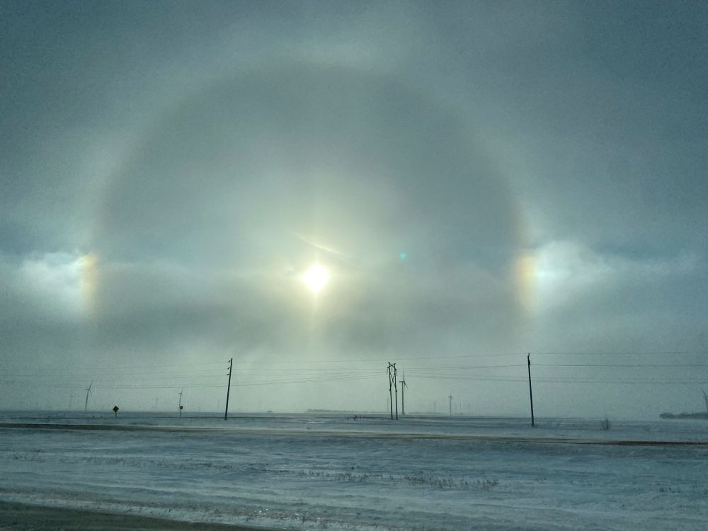
First -30°C of season at Winnipeg Airport with a low of -30.7°C so far this morning. 17 days earlier than average but within the range of expected.
Warmer inside the city but still cold, more like -25 to -27°C.
Coldest temperatures are around Riding Mountain, as low as -34°C.
Warmer inside the city but still cold, more like -25 to -27°C.
Coldest temperatures are around Riding Mountain, as low as -34°C.


December 11, 2024 at 12:56 PM
First -30°C of season at Winnipeg Airport with a low of -30.7°C so far this morning. 17 days earlier than average but within the range of expected.
Warmer inside the city but still cold, more like -25 to -27°C.
Coldest temperatures are around Riding Mountain, as low as -34°C.
Warmer inside the city but still cold, more like -25 to -27°C.
Coldest temperatures are around Riding Mountain, as low as -34°C.
Despite a cold end to the month, November still tied 16th warmest in Winnipeg since 1872.
The big stories were the rainfall and the late first snowfalls.
-2nd rainiest Nov at airport with almost ten times the normal. ☔️
-2nd latest first snowflakes ❄️
-latest first measurable snow ☃️
The big stories were the rainfall and the late first snowfalls.
-2nd rainiest Nov at airport with almost ten times the normal. ☔️
-2nd latest first snowflakes ❄️
-latest first measurable snow ☃️


December 1, 2024 at 5:49 PM
Despite a cold end to the month, November still tied 16th warmest in Winnipeg since 1872.
The big stories were the rainfall and the late first snowfalls.
-2nd rainiest Nov at airport with almost ten times the normal. ☔️
-2nd latest first snowflakes ❄️
-latest first measurable snow ☃️
The big stories were the rainfall and the late first snowfalls.
-2nd rainiest Nov at airport with almost ten times the normal. ☔️
-2nd latest first snowflakes ❄️
-latest first measurable snow ☃️
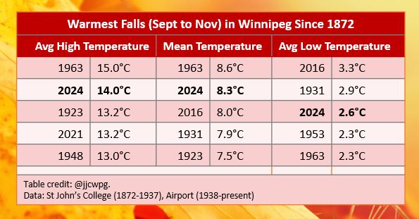
Fall (Sept to Nov) was the 2nd warmest on record in Winnipeg since 1872, beating 2016 but just shy of 1963. It was essentially the cold weather of the past week that prevented us from beating 1963.


December 1, 2024 at 3:58 PM
Fall (Sept to Nov) was the 2nd warmest on record in Winnipeg since 1872, beating 2016 but just shy of 1963. It was essentially the cold weather of the past week that prevented us from beating 1963.
First -30s of the season southwest of Riding Mountain this morning. They may be more widespread tonight in SW Mb. The Red River Valley is much warmer due to cloud cover. Pick your poison, either cloudy skies or extreme cold... Colourful attachment is infrared satellite.


November 29, 2024 at 1:03 PM
First -30s of the season southwest of Riding Mountain this morning. They may be more widespread tonight in SW Mb. The Red River Valley is much warmer due to cloud cover. Pick your poison, either cloudy skies or extreme cold... Colourful attachment is infrared satellite.