


Harald Zandler
@hzandler.bsky.social
Remote Sensing, Geography, Natural Science, Environment. Scientist @ Department of Geography and Regional Science @Uni-Graz.at


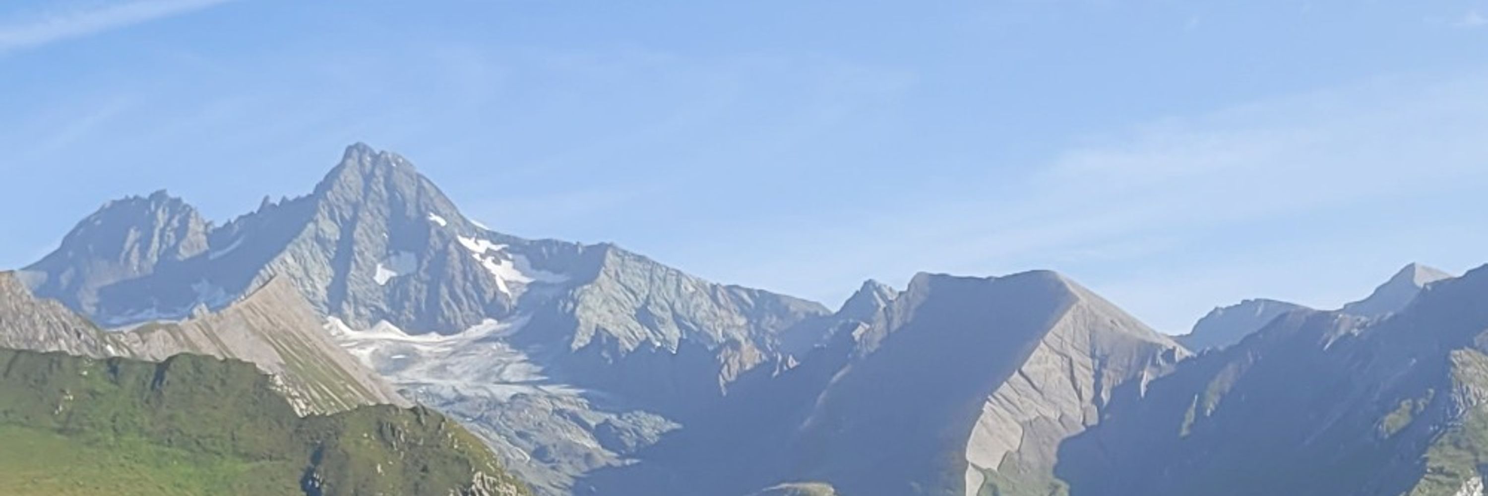
Autumn Time - Mushroom Time 😀


September 27, 2025 at 2:19 PM
Autumn Time - Mushroom Time 😀
Inspired by previous posts of @subfossilguy.bsky.social sky.social and nice visualizations of @stim3on.bsky.social, I created a before and after 3D visualization of the tragic events at Blatten & Birchgletscher. Made possible b#swisstopopo Rapid Mapping imagery and their open data policy
June 2, 2025 at 4:17 PM
Inspired by previous posts of @subfossilguy.bsky.social sky.social and nice visualizations of @stim3on.bsky.social, I created a before and after 3D visualization of the tragic events at Blatten & Birchgletscher. Made possible b#swisstopopo Rapid Mapping imagery and their open data policy
Spring is here at 2470 m.a.s.l.😳 Location: Border Rätikon-Silvretta, Vorarlberg


April 19, 2025 at 12:40 PM
Spring is here at 2470 m.a.s.l.😳 Location: Border Rätikon-Silvretta, Vorarlberg
Today is the first World Day for Glaciers. However, in Austria, glaciers are rapidly vanishing. Here is a 3D comparison of Pasterze 1969-2018. In 2018, the glacier tongue was still well connected to the accumulation area of higher areas. This will soon change:
www.derstandard.de/story/300000...
www.derstandard.de/story/300000...
March 21, 2025 at 7:51 AM
Today is the first World Day for Glaciers. However, in Austria, glaciers are rapidly vanishing. Here is a 3D comparison of Pasterze 1969-2018. In 2018, the glacier tongue was still well connected to the accumulation area of higher areas. This will soon change:
www.derstandard.de/story/300000...
www.derstandard.de/story/300000...
Geographers’ achievement unlocked 😉: had the chance to make a (tiny tiny) contribution to the new school’s atlas for Styria by compiling and coloring the Sentinel-2 mosaic for this nice remote sensing map www.schulatlas.at

November 22, 2024 at 8:16 AM
Geographers’ achievement unlocked 😉: had the chance to make a (tiny tiny) contribution to the new school’s atlas for Styria by compiling and coloring the Sentinel-2 mosaic for this nice remote sensing map www.schulatlas.at
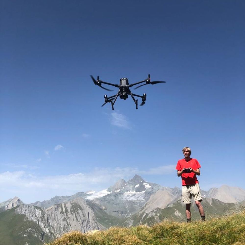
End of summer is field work season. This is our drone mapping #rockglaciers, which are important climate indicators, in Hohe Tauern National Park. The resulting orthophotos allow us to derive flow velocities and compare them with climate trends. #GeoGraz #Permafrost Monitoring

September 3, 2024 at 12:28 PM
End of summer is field work season. This is our drone mapping #rockglaciers, which are important climate indicators, in Hohe Tauern National Park. The resulting orthophotos allow us to derive flow velocities and compare them with climate trends. #GeoGraz #Permafrost Monitoring
Do trees still cool cities despite extreme heat and drought? Yes, but tree species cooling potential strongly varies. This and more in our new #thermal remote sensing publication - covering the current #heatrecord in Franconia in 2022 www.mdpi.com/2072-4292/16...

June 10, 2024 at 9:30 AM
Do trees still cool cities despite extreme heat and drought? Yes, but tree species cooling potential strongly varies. This and more in our new #thermal remote sensing publication - covering the current #heatrecord in Franconia in 2022 www.mdpi.com/2072-4292/16...
Etwas Eigenwerbung: diesen Donnerstag werde ich - im Rahmen des Kolloquiums des Instituts für Geographie und Raumforschung @UniGraz - über Geographische (Fern-)Erkundung im Hindukusch und Pamir sprechen (30.11., 18:00 Uhr, Heinrichstr. 36, Graz, HS 11.03, Foto: Sayeed©WCS 2016)

November 27, 2023 at 2:09 PM
Etwas Eigenwerbung: diesen Donnerstag werde ich - im Rahmen des Kolloquiums des Instituts für Geographie und Raumforschung @UniGraz - über Geographische (Fern-)Erkundung im Hindukusch und Pamir sprechen (30.11., 18:00 Uhr, Heinrichstr. 36, Graz, HS 11.03, Foto: Sayeed©WCS 2016)
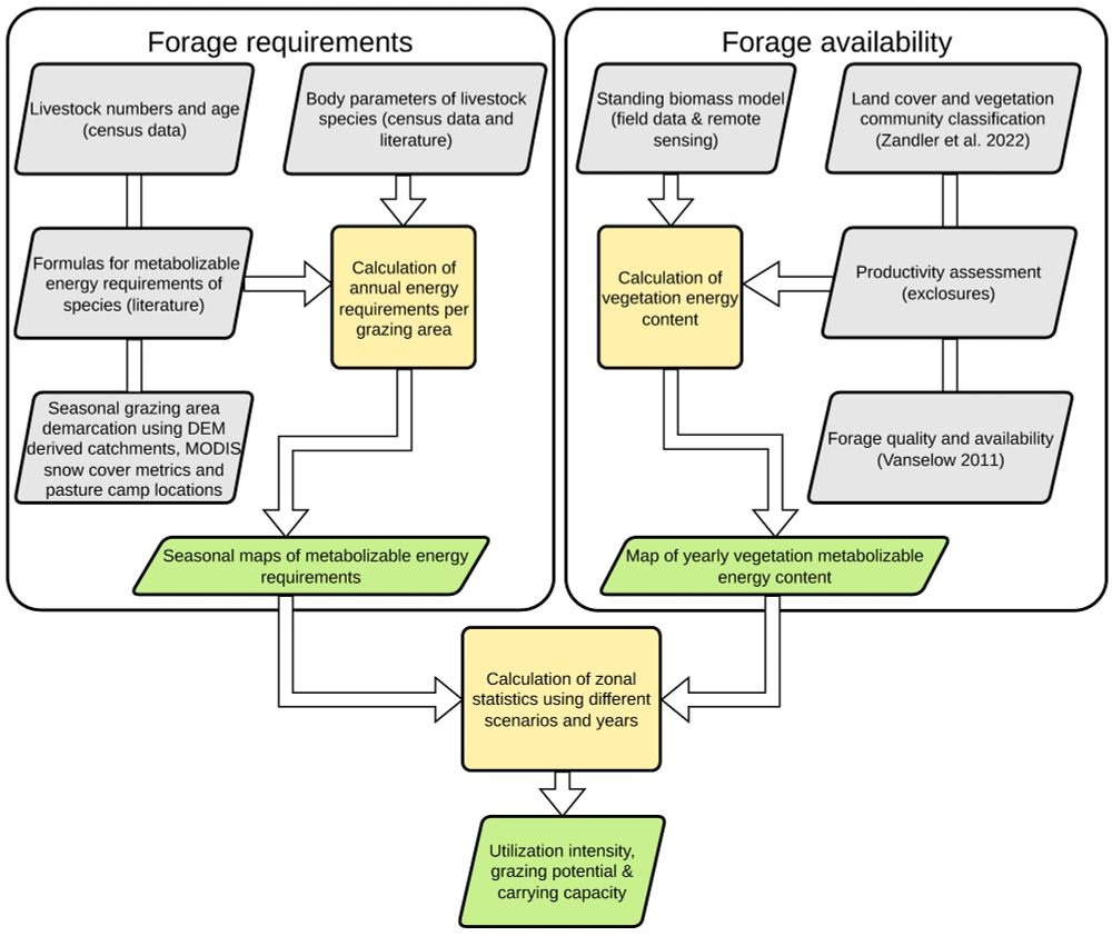
The presented methodology is also applicable in comparable mountain rangelands & allows the identification of unsustainable utilization areas with remote sensing. Warm thanks to all the people involved for making such an assessment possible (10/10)

November 6, 2023 at 5:09 PM
The presented methodology is also applicable in comparable mountain rangelands & allows the identification of unsustainable utilization areas with remote sensing. Warm thanks to all the people involved for making such an assessment possible (10/10)
Another finding was that forage requirements of wild herbivores (ungulates and marmots) were estimated to be negligible compared to livestock, with one tenth of the biomass consumption & no increase in unsustainably grazed pastures due to the wider distribution of animals (9/10)

November 6, 2023 at 5:09 PM
Another finding was that forage requirements of wild herbivores (ungulates and marmots) were estimated to be negligible compared to livestock, with one tenth of the biomass consumption & no increase in unsustainably grazed pastures due to the wider distribution of animals (9/10)
We compared forage amounts consumed by livestock & wild herbivores with availability, which is represented by metabolizable energy content of the vegetation. This showed that several areas experience unsustainable rates of grazing, but also areas with low grazing pressure (8/10)

November 6, 2023 at 5:08 PM
We compared forage amounts consumed by livestock & wild herbivores with availability, which is represented by metabolizable energy content of the vegetation. This showed that several areas experience unsustainable rates of grazing, but also areas with low grazing pressure (8/10)
The transhumance system includes spring, summer and winter pastures. We used field surveys, topographic data and snow maps to demarcate the different grazing areas for a temporal analysis (7/10)

November 6, 2023 at 5:07 PM
The transhumance system includes spring, summer and winter pastures. We used field surveys, topographic data and snow maps to demarcate the different grazing areas for a temporal analysis (7/10)
To gain quantitative insights on fodder demand, extensive surveys of livestock numbers and wild herbivores were performed since 2006. Additional field surveys were used to map pasture camps and grazing areas (6/10)

November 6, 2023 at 5:07 PM
To gain quantitative insights on fodder demand, extensive surveys of livestock numbers and wild herbivores were performed since 2006. Additional field surveys were used to map pasture camps and grazing areas (6/10)
Biomass productivity is also an important variable. To assess yearly productivity of various sites in the field, we also established exclosures in the region with the help of pack animals + yearly clipping. Lab-analysis is also required to derive nutritive value of biomass (5/10)

November 6, 2023 at 5:06 PM
Biomass productivity is also an important variable. To assess yearly productivity of various sites in the field, we also established exclosures in the region with the help of pack animals + yearly clipping. Lab-analysis is also required to derive nutritive value of biomass (5/10)
Assessing forage amounts requires maps on quality & quantity of plant biomass derived by remote sensing models. These models need field data for training & testing, so we mapped vegetation & biomass in 3 expeditions in 2016, 2018 & 2020, walking > 600 km per expedition (4/10)

November 6, 2023 at 5:06 PM
Assessing forage amounts requires maps on quality & quantity of plant biomass derived by remote sensing models. These models need field data for training & testing, so we mapped vegetation & biomass in 3 expeditions in 2016, 2018 & 2020, walking > 600 km per expedition (4/10)
Overgrazing is a threat to biodiversity & productivity, making maps on this issue a key tool for conservation & sustainable management. Remote sensing methods are great for creating spatial information, but a detailed approach requires immense field data and many variables (3/10)
November 6, 2023 at 5:06 PM
Overgrazing is a threat to biodiversity & productivity, making maps on this issue a key tool for conservation & sustainable management. Remote sensing methods are great for creating spatial information, but a detailed approach requires immense field data and many variables (3/10)
Globally, dry rangelands provide resources for half of the world’s livestock. This study was conducted in Wakhan National Park in Afghanistan, which also serves as refugium for rare species, such as the Marco Polo sheep or the snow leopard in addition to many other species (2/10)

November 6, 2023 at 5:05 PM
Globally, dry rangelands provide resources for half of the world’s livestock. This study was conducted in Wakhan National Park in Afghanistan, which also serves as refugium for rare species, such as the Marco Polo sheep or the snow leopard in addition to many other species (2/10)
An intense, fun and successful summer field season is slowly ending - surveying glaciers & rockglaciers with cm accurate RTK UAVs. This week we contributed to the over 100 year long glacier survey of @oeav (gletschermessdienst) by photogrammetrically deriving the edge of Pasterze


September 16, 2023 at 3:41 PM
An intense, fun and successful summer field season is slowly ending - surveying glaciers & rockglaciers with cm accurate RTK UAVs. This week we contributed to the over 100 year long glacier survey of @oeav (gletschermessdienst) by photogrammetrically deriving the edge of Pasterze