


HickmanSevereWx
@hickmanseverewx.bsky.social
Severe weather nowcasting for Hickman Co TN. NWSNashville VERIFIED #tspotter coordinator. NOAA WRN Ambassador. NWS Distinguished Service Award Recipient 2017.
I think the weather is getting just a bit ahead of itself as winter doesn’t start until December 21st.

December 11, 2025 at 6:57 PM
I think the weather is getting just a bit ahead of itself as winter doesn’t start until December 21st.
The rain/sleet/snow line is upon us which could lead to some travel issues over the next several hours.

December 4, 2025 at 8:59 PM
The rain/sleet/snow line is upon us which could lead to some travel issues over the next several hours.
Getting to see this for the third time in the last two years has just been amazing. Barely caught the peak before it faded and now changing to some greens.

November 12, 2025 at 4:31 AM
Getting to see this for the third time in the last two years has just been amazing. Barely caught the peak before it faded and now changing to some greens.
Yall head outside and look north northeast for the northern lights, visible to the naked eye!
This is my view from Bon Aqua with some light pollution.
This is my view from Bon Aqua with some light pollution.

November 12, 2025 at 2:03 AM
Yall head outside and look north northeast for the northern lights, visible to the naked eye!
This is my view from Bon Aqua with some light pollution.
This is my view from Bon Aqua with some light pollution.
The storm in Coble is trying to strengthen as it moves through the area.

November 7, 2025 at 10:21 PM
The storm in Coble is trying to strengthen as it moves through the area.
Sharing at the request of Hickman County EMA for residents of Bucksnort/McEwen.
Controlled detonations are expected throughout the day today. Black smoke can be expected.
Controlled detonations are expected throughout the day today. Black smoke can be expected.

October 12, 2025 at 2:22 PM
Sharing at the request of Hickman County EMA for residents of Bucksnort/McEwen.
Controlled detonations are expected throughout the day today. Black smoke can be expected.
Controlled detonations are expected throughout the day today. Black smoke can be expected.
Sharing at the request of Hickman County EMA:
Residents near Bucksnort/McEwen may hear controlled explosions at times related to the ongoing investigation from yesterday’s incident.
Advance notice will be posted on social media channels.
I will do my best to share those here.
Residents near Bucksnort/McEwen may hear controlled explosions at times related to the ongoing investigation from yesterday’s incident.
Advance notice will be posted on social media channels.
I will do my best to share those here.

October 11, 2025 at 8:04 PM
Sharing at the request of Hickman County EMA:
Residents near Bucksnort/McEwen may hear controlled explosions at times related to the ongoing investigation from yesterday’s incident.
Advance notice will be posted on social media channels.
I will do my best to share those here.
Residents near Bucksnort/McEwen may hear controlled explosions at times related to the ongoing investigation from yesterday’s incident.
Advance notice will be posted on social media channels.
I will do my best to share those here.
New: Severe Thunderstorm Warning for Hickman County until 6:30pm.

September 5, 2025 at 10:28 PM
New: Severe Thunderstorm Warning for Hickman County until 6:30pm.
Non severe storms moving through the county now. Some of the severe warned activity may clip us to the south over the coming hours.

September 5, 2025 at 9:58 PM
Non severe storms moving through the county now. Some of the severe warned activity may clip us to the south over the coming hours.
Excessive Heat Warning for Hickman County until 8pm.
Dangerously hot conditions with heat index values up to 113.
Heat related illnesses increase significantly during
extreme heat and high humidity events.
Dangerously hot conditions with heat index values up to 113.
Heat related illnesses increase significantly during
extreme heat and high humidity events.

July 29, 2025 at 12:31 PM
Excessive Heat Warning for Hickman County until 8pm.
Dangerously hot conditions with heat index values up to 113.
Heat related illnesses increase significantly during
extreme heat and high humidity events.
Dangerously hot conditions with heat index values up to 113.
Heat related illnesses increase significantly during
extreme heat and high humidity events.
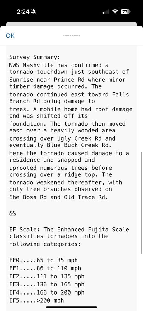
NWSNashville determined an EF0 tornado touched down in the Sunrise Community, including the roads of:
Prince Rd
Falls Branch Rd
Ugly Creek Rd
Blue Buck Creek Rd
She Boss Rd
Old Trace Rd.
Tornado had max winds of 80mph, on the ground for 7 miles, and was 175 yards wide.
Prince Rd
Falls Branch Rd
Ugly Creek Rd
Blue Buck Creek Rd
She Boss Rd
Old Trace Rd.
Tornado had max winds of 80mph, on the ground for 7 miles, and was 175 yards wide.

June 20, 2025 at 7:27 PM
NWSNashville determined an EF0 tornado touched down in the Sunrise Community, including the roads of:
Prince Rd
Falls Branch Rd
Ugly Creek Rd
Blue Buck Creek Rd
She Boss Rd
Old Trace Rd.
Tornado had max winds of 80mph, on the ground for 7 miles, and was 175 yards wide.
Prince Rd
Falls Branch Rd
Ugly Creek Rd
Blue Buck Creek Rd
She Boss Rd
Old Trace Rd.
Tornado had max winds of 80mph, on the ground for 7 miles, and was 175 yards wide.
Rotation has fallen apart in recent scans but as long as the tornado warning is active remain sheltered in your safe spot.

June 19, 2025 at 2:05 AM
Rotation has fallen apart in recent scans but as long as the tornado warning is active remain sheltered in your safe spot.
Rotation will come right through the heart of Duck River/Shady Grove

June 19, 2025 at 2:02 AM
Rotation will come right through the heart of Duck River/Shady Grove
Rotation becoming much more
Clear on radar as this marches toward Jackson Falls and Duck River
Clear on radar as this marches toward Jackson Falls and Duck River

June 19, 2025 at 1:48 AM
Rotation becoming much more
Clear on radar as this marches toward Jackson Falls and Duck River
Clear on radar as this marches toward Jackson Falls and Duck River
Rotation will be headed toward Duck River so everyone in the southern part of the county should be sheltered

June 19, 2025 at 1:35 AM
Rotation will be headed toward Duck River so everyone in the southern part of the county should be sheltered
New: Tornado Warning for Southern Hickman County until 9pm.
Rotation has strengthen in the Brushy community.
Rotation has strengthen in the Brushy community.

June 19, 2025 at 1:32 AM
New: Tornado Warning for Southern Hickman County until 9pm.
Rotation has strengthen in the Brushy community.
Rotation has strengthen in the Brushy community.
No tornado warnings for this rotation, but if I was near this I would be seeking shelter to be extra safe.

June 19, 2025 at 1:31 AM
No tornado warnings for this rotation, but if I was near this I would be seeking shelter to be extra safe.
Watching rotation in the Brushy community.

June 19, 2025 at 1:28 AM
Watching rotation in the Brushy community.
Still watching this area of rotation coming up on the Brushy community.
No warning but is being carefully watched
No warning but is being carefully watched

June 19, 2025 at 1:17 AM
Still watching this area of rotation coming up on the Brushy community.
No warning but is being carefully watched
No warning but is being carefully watched
Rotation still evident in the Pleasantville area. It’s being watched closely

June 19, 2025 at 1:07 AM
Rotation still evident in the Pleasantville area. It’s being watched closely
Some rotation still evident on radar but the warning was allowed to expire.
Storm might be cycling or it could be weakening.
Stay away from windows and doors and stay in the center of your home just in case
Storm might be cycling or it could be weakening.
Stay away from windows and doors and stay in the center of your home just in case

June 19, 2025 at 1:03 AM
Some rotation still evident on radar but the warning was allowed to expire.
Storm might be cycling or it could be weakening.
Stay away from windows and doors and stay in the center of your home just in case
Storm might be cycling or it could be weakening.
Stay away from windows and doors and stay in the center of your home just in case
Rotation is weakening which is good but still watching them.

June 19, 2025 at 12:58 AM
Rotation is weakening which is good but still watching them.
Rotation coming into Pleasantville now still fairly evident.

June 19, 2025 at 12:53 AM
Rotation coming into Pleasantville now still fairly evident.
New: Tornado Warning for Southern Hickman County until 8:00pm
Take shelter if you’re in Centerville or south
Take shelter if you’re in Centerville or south

June 19, 2025 at 12:40 AM
New: Tornado Warning for Southern Hickman County until 8:00pm
Take shelter if you’re in Centerville or south
Take shelter if you’re in Centerville or south
Rotation signature in this tornado warning for Perry County still evident. Would not be surprised if a tornado warning is issued soon.

June 19, 2025 at 12:32 AM
Rotation signature in this tornado warning for Perry County still evident. Would not be surprised if a tornado warning is issued soon.