


Hans Hack
@hanshack.bsky.social
web developer, data visualizer, map maker, artist
hanshack.com
works @ odis-berlin.de
hanshack.com
works @ odis-berlin.de
🚗➡️🌳 Berlin wants to plant a million new trees by 2040.
But why wait? Let’s start now.
In P2T (Parking to Tree) you’ve got 60 seconds to turn parking spaces into trees.
Play the tiny game turning asphalt into green friends 💚
🔗 hanshack.com/p2t
But why wait? Let’s start now.
In P2T (Parking to Tree) you’ve got 60 seconds to turn parking spaces into trees.
Play the tiny game turning asphalt into green friends 💚
🔗 hanshack.com/p2t

P2T — Parking to Tree Game 🌳
Turn parking spaces into trees in 60 seconds 🌳 P2T (Parking to Tree) is a tiny browser game inspired by Berlin’s goal to plant 1 million new trees by 2040.
hanshack.com
November 7, 2025 at 2:03 PM
🚗➡️🌳 Berlin wants to plant a million new trees by 2040.
But why wait? Let’s start now.
In P2T (Parking to Tree) you’ve got 60 seconds to turn parking spaces into trees.
Play the tiny game turning asphalt into green friends 💚
🔗 hanshack.com/p2t
But why wait? Let’s start now.
In P2T (Parking to Tree) you’ve got 60 seconds to turn parking spaces into trees.
Play the tiny game turning asphalt into green friends 💚
🔗 hanshack.com/p2t
🌍 Maptime Berlin 2025 🌍
The popular Maptime Meetup returns to CityLAB Berlin
📅 When: Wednesday, November 12, 2025, 5:30–9:00 p.m.
📍 Where: CityLAB Berlin, Platz der Luftbrücke 4, 12101 Berlin
The popular Maptime Meetup returns to CityLAB Berlin
📅 When: Wednesday, November 12, 2025, 5:30–9:00 p.m.
📍 Where: CityLAB Berlin, Platz der Luftbrücke 4, 12101 Berlin
October 9, 2025 at 3:57 PM
🌍 Maptime Berlin 2025 🌍
The popular Maptime Meetup returns to CityLAB Berlin
📅 When: Wednesday, November 12, 2025, 5:30–9:00 p.m.
📍 Where: CityLAB Berlin, Platz der Luftbrücke 4, 12101 Berlin
The popular Maptime Meetup returns to CityLAB Berlin
📅 When: Wednesday, November 12, 2025, 5:30–9:00 p.m.
📍 Where: CityLAB Berlin, Platz der Luftbrücke 4, 12101 Berlin
Reposted by Hans Hack

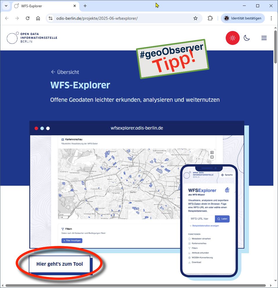
ODIS Berlin: Der WFS-Explorer! / The WFS-Explorer! geoobserver.de/2025/07/22/o... #wfs #webfeatureservice #ogc #gistribe #gischat #fossgis #foss4g #OSGeo #spatial #geospatial #opensource #gis #geo #geoObserver pls RT via @hanshack@troet.cafe
July 22, 2025 at 7:02 AM
ODIS Berlin: Der WFS-Explorer! / The WFS-Explorer! geoobserver.de/2025/07/22/o... #wfs #webfeatureservice #ogc #gistribe #gischat #fossgis #foss4g #OSGeo #spatial #geospatial #opensource #gis #geo #geoObserver pls RT via @hanshack@troet.cafe
🌐 New Tool: The WFS Explorer
WFS (Web Feature Services) deliver geodata over the web — but require complex tools and can be a pain to work with.
WFS Explorer is a free, open source, browser-based tool to search, explore, and analyze WFS data — quickly and without the need for expert knowledge.
WFS (Web Feature Services) deliver geodata over the web — but require complex tools and can be a pain to work with.
WFS Explorer is a free, open source, browser-based tool to search, explore, and analyze WFS data — quickly and without the need for expert knowledge.
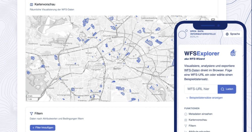
WFS-Explorer
Visualize, analyze and export WFS Data directly in the browser.
wfsexplorer.odis-berlin.de
July 3, 2025 at 8:41 AM
🌐 New Tool: The WFS Explorer
WFS (Web Feature Services) deliver geodata over the web — but require complex tools and can be a pain to work with.
WFS Explorer is a free, open source, browser-based tool to search, explore, and analyze WFS data — quickly and without the need for expert knowledge.
WFS (Web Feature Services) deliver geodata over the web — but require complex tools and can be a pain to work with.
WFS Explorer is a free, open source, browser-based tool to search, explore, and analyze WFS data — quickly and without the need for expert knowledge.
Reposted by Hans Hack

People tell me nobody wants to look at climate curves anymore, yet here we are!!! Please enjoy our interactive journey through 485 million years of climate history and dive into the fascinating and important work of paleoclimate scientists.
🎁 www.zeit.de/wissen/umwel...
🎁 www.zeit.de/wissen/umwel...
June 20, 2025 at 9:32 AM
People tell me nobody wants to look at climate curves anymore, yet here we are!!! Please enjoy our interactive journey through 485 million years of climate history and dive into the fascinating and important work of paleoclimate scientists.
🎁 www.zeit.de/wissen/umwel...
🎁 www.zeit.de/wissen/umwel...
Reposted by Hans Hack
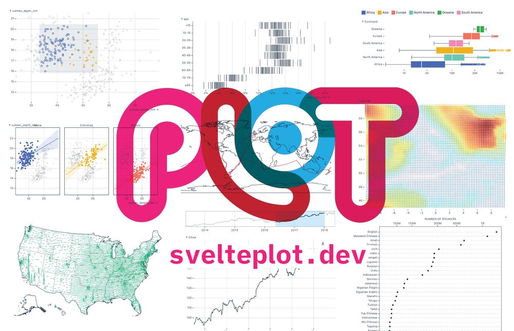
Last week I had the pleasure of finally releasing the #SveltePlot alpha version during my talk at the #SvelteSummit in Barcelona. It's a new visualization framework for @svelte.dev that I've been working on for the past 18 months, so it's about time for a 🧵
May 13, 2025 at 11:21 AM
Last week I had the pleasure of finally releasing the #SveltePlot alpha version during my talk at the #SvelteSummit in Barcelona. It's a new visualization framework for @svelte.dev that I've been working on for the past 18 months, so it's about time for a 🧵
How much space do car parks actually take up compared to playgrounds and green spaces? I made a tool that allows you to explore and compare these public spaces in Berlin.
www.hanshack.com/parking/
www.hanshack.com/parking/
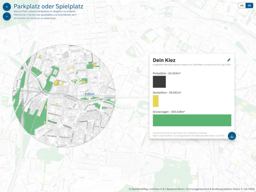
Parking or Playground
This map allows you to compare the size of parking areas, playgrounds, and green spaces in your neighborhood.
www.hanshack.com
July 11, 2024 at 6:48 AM
How much space do car parks actually take up compared to playgrounds and green spaces? I made a tool that allows you to explore and compare these public spaces in Berlin.
www.hanshack.com/parking/
www.hanshack.com/parking/
Reposted by Hans Hack

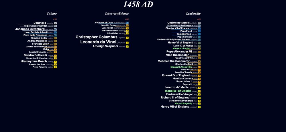
NEW Very quick and small #dataviz experiment: parallel-lives, an interactive timeline of nearly 5000 years of notable people in history. janwillemtulp.github.io/parallel-liv... 3 reasons what I like about this approach:
March 6, 2024 at 9:28 AM
NEW Very quick and small #dataviz experiment: parallel-lives, an interactive timeline of nearly 5000 years of notable people in history. janwillemtulp.github.io/parallel-liv... 3 reasons what I like about this approach:
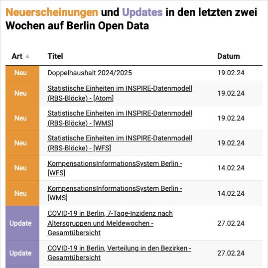
Keep updated with the newest publications and updates on the Berlin Open Data Portal. The new Chart keeps you informed on a daily basis, as it updates automatically and is easy to embed. odis-berlin.de/projekte/dat...
February 28, 2024 at 8:42 AM
Keep updated with the newest publications and updates on the Berlin Open Data Portal. The new Chart keeps you informed on a daily basis, as it updates automatically and is easy to embed. odis-berlin.de/projekte/dat...
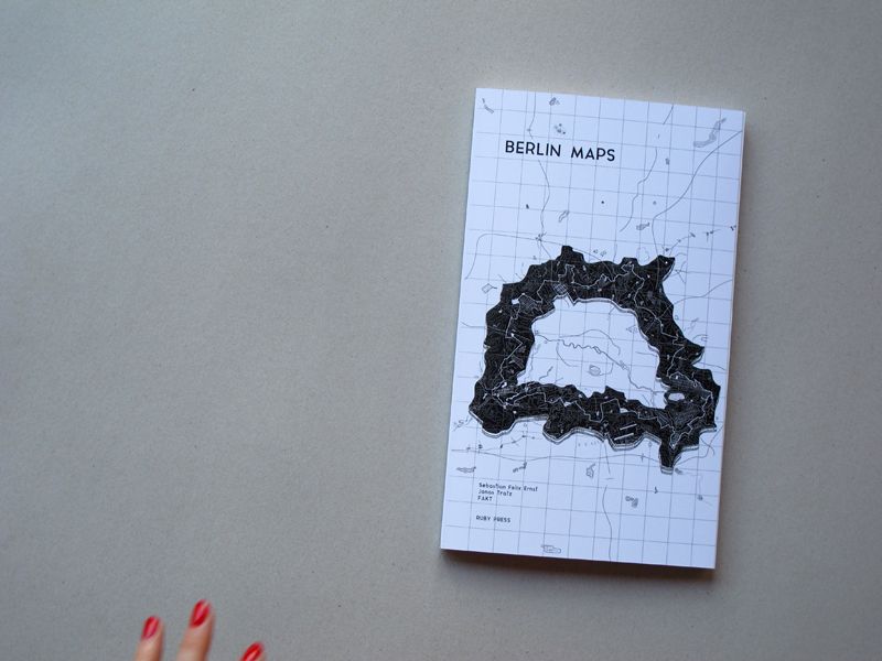
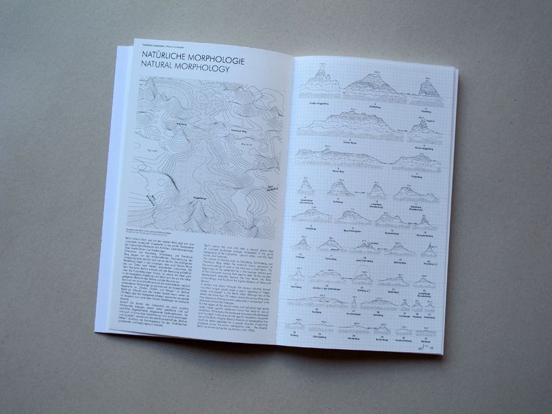
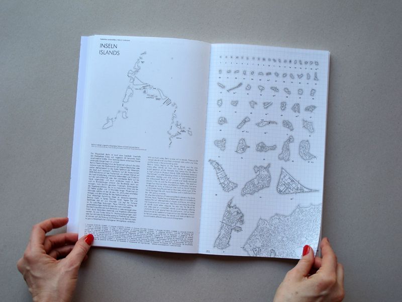
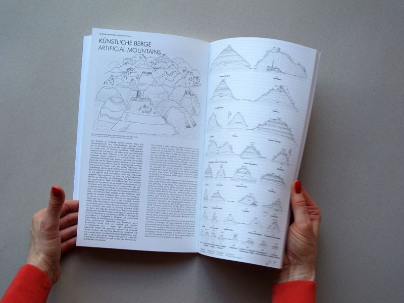
I recently discovered the book "Berlin Maps", which explores Berlin’s distinctive geography, history, and hidden treasures through beautiful maps and short texts. If you're intrigued by maps and urban development, I recommend checking it out: ruby-press.com/shop/berlin-...
February 9, 2024 at 7:11 AM
I recently discovered the book "Berlin Maps", which explores Berlin’s distinctive geography, history, and hidden treasures through beautiful maps and short texts. If you're intrigued by maps and urban development, I recommend checking it out: ruby-press.com/shop/berlin-...
🌍 Maptime Berlin is back!
When: Thursday, 29. February from 6 p.m.
Where: CityLAB Berlin, Platz der Luftbrücke 4, 12101 Berlin
Food: 🍕
Register here: citylab-berlin.org/de/events/ma... or on meetup.com
When: Thursday, 29. February from 6 p.m.
Where: CityLAB Berlin, Platz der Luftbrücke 4, 12101 Berlin
Food: 🍕
Register here: citylab-berlin.org/de/events/ma... or on meetup.com
February 1, 2024 at 10:52 AM
🌍 Maptime Berlin is back!
When: Thursday, 29. February from 6 p.m.
Where: CityLAB Berlin, Platz der Luftbrücke 4, 12101 Berlin
Food: 🍕
Register here: citylab-berlin.org/de/events/ma... or on meetup.com
When: Thursday, 29. February from 6 p.m.
Where: CityLAB Berlin, Platz der Luftbrücke 4, 12101 Berlin
Food: 🍕
Register here: citylab-berlin.org/de/events/ma... or on meetup.com
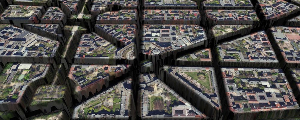
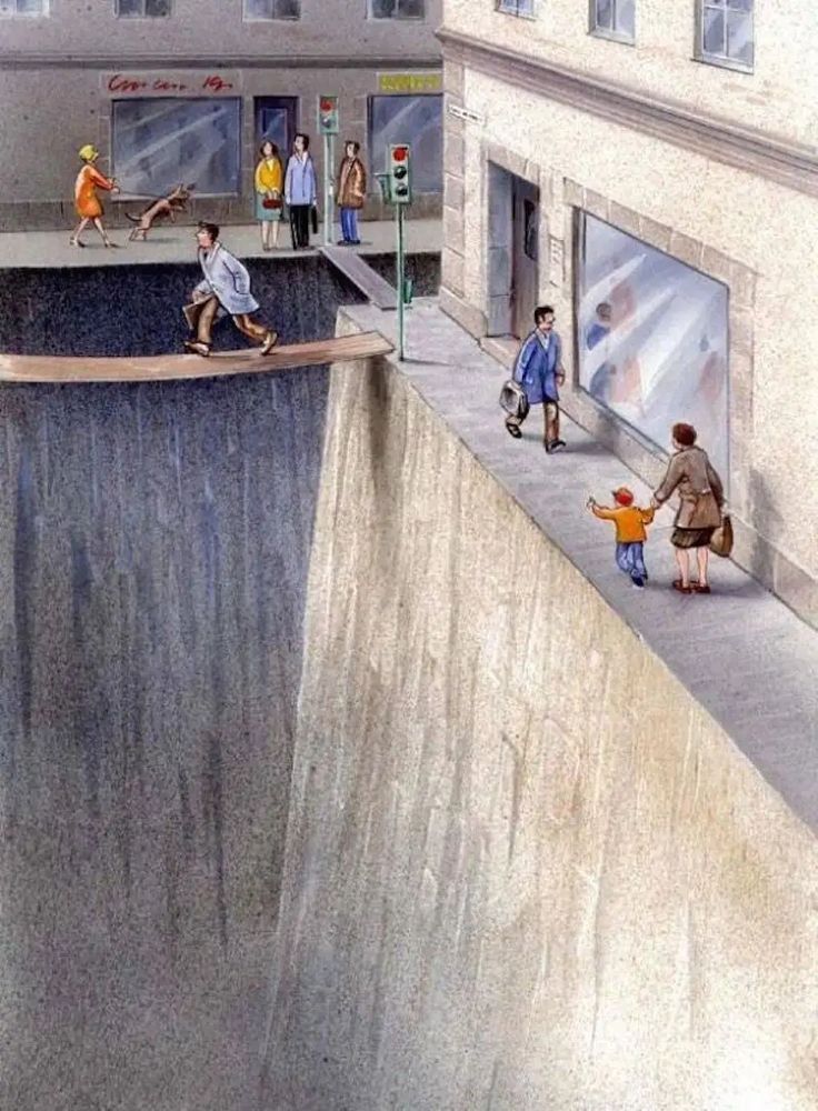
Street Canyons:
A map experiment depicting Berlins streets as canyons, carving through the city's landscape. Inspired by a drawing from Karl Jilg.
hanshack.com/street-canyo...
A map experiment depicting Berlins streets as canyons, carving through the city's landscape. Inspired by a drawing from Karl Jilg.
hanshack.com/street-canyo...
November 14, 2023 at 8:54 AM
Street Canyons:
A map experiment depicting Berlins streets as canyons, carving through the city's landscape. Inspired by a drawing from Karl Jilg.
hanshack.com/street-canyo...
A map experiment depicting Berlins streets as canyons, carving through the city's landscape. Inspired by a drawing from Karl Jilg.
hanshack.com/street-canyo...