


Geoff Wallace
@geoffmakesmaps.bsky.social
Cartographer with a PhD in history, vintage cycling enthusiast, and problem vinyl hoarder in Durham, UK. landscapearchive.com
It's #StarTrek Day. I can't overstate how important this franchise was to me growing up and how relevant it remains to me today. But the fact that the weasels at Paramount are profiting from its utopian vision of the future makes my skin crawl. It's also mostly kept me away from the new shows.
September 8, 2025 at 9:51 AM
It's #StarTrek Day. I can't overstate how important this franchise was to me growing up and how relevant it remains to me today. But the fact that the weasels at Paramount are profiting from its utopian vision of the future makes my skin crawl. It's also mostly kept me away from the new shows.
Hugo Ikehara–Tsukayama, Sofia Ortega-Guerrero, and I wrote an article about our decisions and the production process behind the animated map of the Americas for the Met Museum's Michael C. Rockefeller Wing!
#gischat #history #arthistory #gis #cartography #maps
#gischat #history #arthistory #gis #cartography #maps

Visualizing the History of Connections in the Ancient American Art Galleries - The Metropolitan Museum of Art
A new state-of-the-art digital map welcomes and orients visitors upon entering the Ancient American Art galleries.
www.metmuseum.org
June 5, 2025 at 10:32 AM
Hugo Ikehara–Tsukayama, Sofia Ortega-Guerrero, and I wrote an article about our decisions and the production process behind the animated map of the Americas for the Met Museum's Michael C. Rockefeller Wing!
#gischat #history #arthistory #gis #cartography #maps
#gischat #history #arthistory #gis #cartography #maps
Early colonial Yucatán. This map appears in "The Friar and the Maya: Diego de Landa and the Account of the Things of Yucatan" by @restall.bsky.social, Amara Solari, John F. Chuchiak, and Traci Ardren (2023, Univ. Press of Colorado).
#mapmonday #GISchat #history
#mapmonday #GISchat #history

December 16, 2024 at 10:44 PM
Early colonial Yucatán. This map appears in "The Friar and the Maya: Diego de Landa and the Account of the Things of Yucatan" by @restall.bsky.social, Amara Solari, John F. Chuchiak, and Traci Ardren (2023, Univ. Press of Colorado).
#mapmonday #GISchat #history
#mapmonday #GISchat #history
Reposted by Geoff Wallace
AGU put out a press release about our #AGU2024 presentations on the Bering Land Bridge (which, ICYMI is it a massive amount of exposed land during sea level lowstands!)
Check out the teaser below and come see our posters if you are in town! PP23C-0564 to 0569 (Tuesday afternoon)
Check out the teaser below and come see our posters if you are in town! PP23C-0564 to 0569 (Tuesday afternoon)

Bering Bog Bridge? New research rewrites key crossing’s landscape
New research finds Bering Land Bridge was boggy with meandering rivers, not an arid steppe as previously thought
news.agu.org
December 9, 2024 at 2:53 PM
AGU put out a press release about our #AGU2024 presentations on the Bering Land Bridge (which, ICYMI is it a massive amount of exposed land during sea level lowstands!)
Check out the teaser below and come see our posters if you are in town! PP23C-0564 to 0569 (Tuesday afternoon)
Check out the teaser below and come see our posters if you are in town! PP23C-0564 to 0569 (Tuesday afternoon)
The Pacific. This map appears as a double-page frontispiece in "Migrant Ecologies: Environmental Histories of the Pacific World" (ed. Beattie, Jones, & Melillo, University of Hawai'i Press, 2022).
#mapmonday #cartography #envhist #GISchat
#mapmonday #cartography #envhist #GISchat

December 2, 2024 at 4:47 PM
The Pacific. This map appears as a double-page frontispiece in "Migrant Ecologies: Environmental Histories of the Pacific World" (ed. Beattie, Jones, & Melillo, University of Hawai'i Press, 2022).
#mapmonday #cartography #envhist #GISchat
#mapmonday #cartography #envhist #GISchat
I'm currently working on an atlas of environmental history with a few historian colleagues of mine. It won't be ready for a few years, but here's a sneak peek.
#envhist #history #maps #gischat #cartography
#envhist #history #maps #gischat #cartography

November 18, 2024 at 12:54 PM
I'm currently working on an atlas of environmental history with a few historian colleagues of mine. It won't be ready for a few years, but here's a sneak peek.
#envhist #history #maps #gischat #cartography
#envhist #history #maps #gischat #cartography
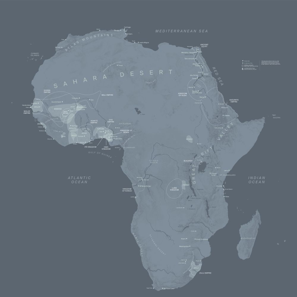
I do maps for museums too! This map of early civilizations in Africa was on the wall at the @metmuseum.bsky.social last year, and I've got another 30-or-so maps going up at the Met when they finish the Rockefeller Wing renovations later this year!
#maps #cartography #history #gischat
#maps #cartography #history #gischat
November 18, 2024 at 12:52 PM
I do maps for museums too! This map of early civilizations in Africa was on the wall at the @metmuseum.bsky.social last year, and I've got another 30-or-so maps going up at the Met when they finish the Rockefeller Wing renovations later this year!
#maps #cartography #history #gischat
#maps #cartography #history #gischat

November 18, 2024 at 12:50 PM
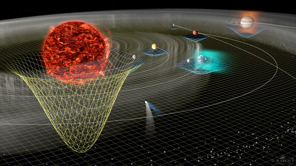
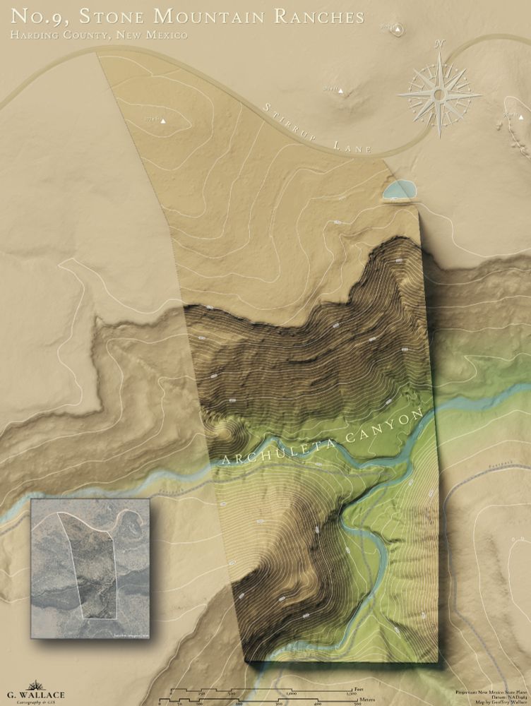
I also occasionally faff about in Blender, where I made this map of the solar system for @dagomardegroot.bsky.social and this wall map of a land parcel in New Mexico for a friend.
#gischat #cartography #maps #geosky
#gischat #cartography #maps #geosky
November 18, 2024 at 12:49 PM
I also occasionally faff about in Blender, where I made this map of the solar system for @dagomardegroot.bsky.social and this wall map of a land parcel in New Mexico for a friend.
#gischat #cartography #maps #geosky
#gischat #cartography #maps #geosky
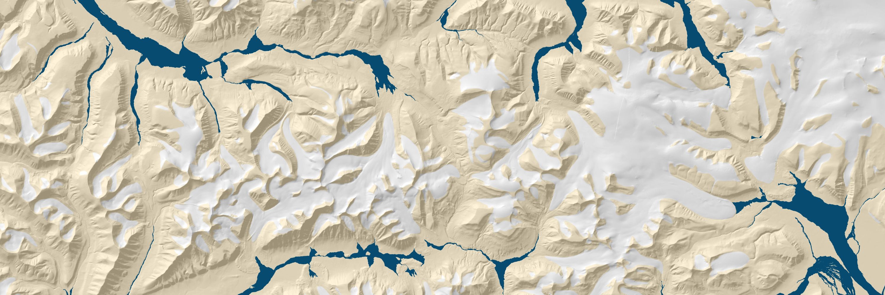
I also make maps for print publications, most recently a huge set of 30 different maps for an upcoming collection on climate history from Oxford University Press.
#gischat #maps #cartography #geosky
#gischat #maps #cartography #geosky

November 18, 2024 at 12:47 PM
I also make maps for print publications, most recently a huge set of 30 different maps for an upcoming collection on climate history from Oxford University Press.
#gischat #maps #cartography #geosky
#gischat #maps #cartography #geosky
Intro time! I'm a mapmaker who works mostly on historical cartography, but occasionally does more contemporary stuff (like this map of ESNET6 I made for the US Department of Energy a few years back)!
#gischat #cartography #maps
#gischat #cartography #maps

November 18, 2024 at 12:22 PM
Intro time! I'm a mapmaker who works mostly on historical cartography, but occasionally does more contemporary stuff (like this map of ESNET6 I made for the US Department of Energy a few years back)!
#gischat #cartography #maps
#gischat #cartography #maps