


Tom Swetnam
@firescar.bsky.social
Tree-ring scientist, forest ecologist, forest fires, climate and human interactions. Regents Professor Emeritus Univ AZ; home in New Mexico.
Last, this study demonstrates (again) that fire scar networks in Southwestern ponderosa pine dominant fire regimes can provide highly reliable and accurate estimates of fire extent and related fire regime metrics (e.g., fire frequency, fire rotation, etc.). 6/6

February 5, 2026 at 9:17 PM
Last, this study demonstrates (again) that fire scar networks in Southwestern ponderosa pine dominant fire regimes can provide highly reliable and accurate estimates of fire extent and related fire regime metrics (e.g., fire frequency, fire rotation, etc.). 6/6
All models performed very well, demonstrating that even relatively low spatial density fire scar networks can be used to quantitatively and accurately estimate area burned over time. Prescribed fire programs in these two wilderness areas have effectively restored the pre-1900 fire regimes. 4/6

February 5, 2026 at 9:17 PM
All models performed very well, demonstrating that even relatively low spatial density fire scar networks can be used to quantitatively and accurately estimate area burned over time. Prescribed fire programs in these two wilderness areas have effectively restored the pre-1900 fire regimes. 4/6
This is a new and important advance in dendrochronology, because, to my knowledge, this is the first time a spatial ecological process has been reconstructed using tree-ring event networks at these scales, resolutions, and with very high levels of statistical accuracy (r-squared = 0.88 to 0.98). 3/6

February 5, 2026 at 9:17 PM
This is a new and important advance in dendrochronology, because, to my knowledge, this is the first time a spatial ecological process has been reconstructed using tree-ring event networks at these scales, resolutions, and with very high levels of statistical accuracy (r-squared = 0.88 to 0.98). 3/6
Spatial networks of fire scarred trees and twentieth-century burned area observations in the form of mapped fire perimeters (fire atlases) were used to calibrate and validate reconstructions of area burned in absolute values, that is hectares burned per year, extending back to the early 1700s. 2/6

February 5, 2026 at 9:17 PM
Spatial networks of fire scarred trees and twentieth-century burned area observations in the form of mapped fire perimeters (fire atlases) were used to calibrate and validate reconstructions of area burned in absolute values, that is hectares burned per year, extending back to the early 1700s. 2/6
My colleagues Calvin Farris (NPS) and Ellis Margolis (USGS) led a landmark study in paleofire reconstruction. In addition to showing that fire management can restore past fire regimes, the demonstrated methods are a first in dendrochronology. 1/6 esajournals.onlinelibrary.wiley.com/doi/10.1002/...

February 5, 2026 at 9:17 PM
My colleagues Calvin Farris (NPS) and Ellis Margolis (USGS) led a landmark study in paleofire reconstruction. In addition to showing that fire management can restore past fire regimes, the demonstrated methods are a first in dendrochronology. 1/6 esajournals.onlinelibrary.wiley.com/doi/10.1002/...
The continued destruction of science by the US administration is beyond appalling and disgusting. This includes the withdrawal of the the US from IAI, Inter-American Institute for Global Change Research. This is a massive mistake and loss for all.

January 9, 2026 at 1:54 AM
The continued destruction of science by the US administration is beyond appalling and disgusting. This includes the withdrawal of the the US from IAI, Inter-American Institute for Global Change Research. This is a massive mistake and loss for all.
References and further reading about Gila fire history and ecology studies: 18/18

July 20, 2025 at 1:36 PM
References and further reading about Gila fire history and ecology studies: 18/18
However, initial burns in parts of this landscape have exacted a cost in tree mortality in some large patches. Where can the Gila exemplar be replicated? Undoubtedly, a different tack including other management strategies is needed in smaller Wilderness areas and the Wildland Urban Interface.17/18

July 20, 2025 at 1:36 PM
However, initial burns in parts of this landscape have exacted a cost in tree mortality in some large patches. Where can the Gila exemplar be replicated? Undoubtedly, a different tack including other management strategies is needed in smaller Wilderness areas and the Wildland Urban Interface.17/18
In sum, the Gila is an exemplar of a “restored” high-frequency surface fire regime. Wildfires burning today, even during drought, are generally constrained in severity by previous burns. This photo is from 2013 on Iron Creek Mesa, with previous burns in 1985, 2003, 2012, and now again in 2025. 16/18

July 20, 2025 at 1:36 PM
In sum, the Gila is an exemplar of a “restored” high-frequency surface fire regime. Wildfires burning today, even during drought, are generally constrained in severity by previous burns. This photo is from 2013 on Iron Creek Mesa, with previous burns in 1985, 2003, 2012, and now again in 2025. 16/18
Approximate same view as previous image from an airplane in about 2000, prior to managed and wildfires burning large canopy holes on the ponderosa pine/mixed conifer mesas, and up over the spruce-fir forests on the high ridges and peaks of the Mogollons. 15/18

July 20, 2025 at 1:36 PM
Approximate same view as previous image from an airplane in about 2000, prior to managed and wildfires burning large canopy holes on the ponderosa pine/mixed conifer mesas, and up over the spruce-fir forests on the high ridges and peaks of the Mogollons. 15/18
Although the Turkeyfeather Fire seems to have burned mostly low severity, past fires that were managed or were designated wildfires, have created a mosaic of high, moderate, and low severity burn patches. The Whitewater Baldy Fire of 2012 burned very severely across parts of the Mogollon Mtns. 14/18

July 20, 2025 at 1:36 PM
Although the Turkeyfeather Fire seems to have burned mostly low severity, past fires that were managed or were designated wildfires, have created a mosaic of high, moderate, and low severity burn patches. The Whitewater Baldy Fire of 2012 burned very severely across parts of the Mogollon Mtns. 14/18
Fire spread limited by the multiple previous burns is evident in the 2025 Turkeyfeather Fire footprint. The perimeter within the Wilderness and just outside to the north extends to the perimeters of several previous fires within the past few decades. 13/18

July 20, 2025 at 1:36 PM
Fire spread limited by the multiple previous burns is evident in the 2025 Turkeyfeather Fire footprint. The perimeter within the Wilderness and just outside to the north extends to the perimeters of several previous fires within the past few decades. 13/18
Using the fire scar network data and spatial models calibrated with fire atlas data, Farris et al (in review) reconstruct area burned in the White Creek Watershed since 1750. The modern era of fire reintroduction in the Gila is now within the range of area burned that occurred pre-1900. 12/18

July 20, 2025 at 1:36 PM
Using the fire scar network data and spatial models calibrated with fire atlas data, Farris et al (in review) reconstruct area burned in the White Creek Watershed since 1750. The modern era of fire reintroduction in the Gila is now within the range of area burned that occurred pre-1900. 12/18
White Creek study area encompassing the Langstroth Mesa and Snow Park fire scar transect, showing fire scar plots and number of times burned since 1909. 11/18

July 20, 2025 at 1:36 PM
White Creek study area encompassing the Langstroth Mesa and Snow Park fire scar transect, showing fire scar plots and number of times burned since 1909. 11/18
Molly Hunter, Jose Iniguez, and Cal Farris (2014) updated the Gila Fire atlas, 1909-2013, showing some areas burned as frequently as 8 times, with many large managed and wildfires during the dry and hot 2000s. 10/18

July 20, 2025 at 1:36 PM
Molly Hunter, Jose Iniguez, and Cal Farris (2014) updated the Gila Fire atlas, 1909-2013, showing some areas burned as frequently as 8 times, with many large managed and wildfires during the dry and hot 2000s. 10/18
Since 1977 the Gila has allowed many lightning-ignited fires to burn, resulting in a transformed landscape. Matt Rollins studied the Gila-Aldo Leopold 20th-century burn patterns for his PhD dissertation work at UA. Set of maps of the 6 largest fire years in the Gila, Rollins et al. 2001. 9/18

July 20, 2025 at 1:36 PM
Since 1977 the Gila has allowed many lightning-ignited fires to burn, resulting in a transformed landscape. Matt Rollins studied the Gila-Aldo Leopold 20th-century burn patterns for his PhD dissertation work at UA. Set of maps of the 6 largest fire years in the Gila, Rollins et al. 2001. 9/18
Another study was done by MS degree student Rena Ann Abolt in 1997. This was a transect of collections from ponderosa pine on Langstroth Mesa at about 2,400 m up to mixed conifer forests at Snow Park 3,200 m. Fires spread across the elevation gradient, with fewer events at high elevations. 8/18

July 20, 2025 at 1:36 PM
Another study was done by MS degree student Rena Ann Abolt in 1997. This was a transect of collections from ponderosa pine on Langstroth Mesa at about 2,400 m up to mixed conifer forests at Snow Park 3,200 m. Fires spread across the elevation gradient, with fewer events at high elevations. 8/18
The master fire scar chronology charts from all three study areas shows 1 or 2 fires per decade burning most of the study area from the 1700s to ca. 1900. Livestock grazing and organized firefighting by the Forest Service by 1910 effectively eliminated the frequent, low-intensity surface fires. 7/18

July 20, 2025 at 1:36 PM
The master fire scar chronology charts from all three study areas shows 1 or 2 fires per decade burning most of the study area from the 1700s to ca. 1900. Livestock grazing and organized firefighting by the Forest Service by 1910 effectively eliminated the frequent, low-intensity surface fires. 7/18
The Gila fire scars showed widespread fires over the study areas prior to 1900, then a sharp cessation in burning. The McKenna Park fire chronology, with the Little Creek Fire showing up in the samples east of the old airstrip. My father Fred, who was with the FS, was on that 1951 fire. 6/18

July 20, 2025 at 1:36 PM
The Gila fire scars showed widespread fires over the study areas prior to 1900, then a sharp cessation in burning. The McKenna Park fire chronology, with the Little Creek Fire showing up in the samples east of the old airstrip. My father Fred, who was with the FS, was on that 1951 fire. 6/18
My graduate studies were at the University of Arizona’s Laboratory of Tree-Ring Research. My master’s thesis (1983) “Fire History of the Gila Wilderness” included a description of past fire frequencies and extent over three sub-areas within the Wilderness. Map from Swetnam and Dieterich 1985. 5/18

July 20, 2025 at 1:36 PM
My graduate studies were at the University of Arizona’s Laboratory of Tree-Ring Research. My master’s thesis (1983) “Fire History of the Gila Wilderness” included a description of past fire frequencies and extent over three sub-areas within the Wilderness. Map from Swetnam and Dieterich 1985. 5/18
After a horse & mule pack trip in the Wilderness with scientist Jack Dieterich I decided to attend graduate school and study fire history using tree rings. In 1980-81 we collected fire-scarred tree samples from 3 study areas. Peter Brown and me using the misery whip on Langstroth Mesa. 4/18

July 20, 2025 at 1:36 PM
After a horse & mule pack trip in the Wilderness with scientist Jack Dieterich I decided to attend graduate school and study fire history using tree rings. In 1980-81 we collected fire-scarred tree samples from 3 study areas. Peter Brown and me using the misery whip on Langstroth Mesa. 4/18
Initial attack firefighting in the Gila was an awesome experience. We flew to wildfires and put them out using hand tools, including the “misery whip.” Then we hiked out of the Wilderness. Chris Baisan, a firefighting buddy on the Gila, and later my tree-ring colleague for nearly 40 years. 3/18

July 20, 2025 at 1:36 PM
Initial attack firefighting in the Gila was an awesome experience. We flew to wildfires and put them out using hand tools, including the “misery whip.” Then we hiked out of the Wilderness. Chris Baisan, a firefighting buddy on the Gila, and later my tree-ring colleague for nearly 40 years. 3/18
I was on a helitack crew located at the Gila Cliff Dwellings for 3 seasons (1978-80). (I’m 3rd from the right, standing.) My boss was Lawrence Garcia, a legendary FMO (4th from left, standing). We fought fire through the summer, and then we monitored “prescribed natural fires” in the fall. 2/18

July 20, 2025 at 1:36 PM
I was on a helitack crew located at the Gila Cliff Dwellings for 3 seasons (1978-80). (I’m 3rd from the right, standing.) My boss was Lawrence Garcia, a legendary FMO (4th from left, standing). We fought fire through the summer, and then we monitored “prescribed natural fires” in the fall. 2/18
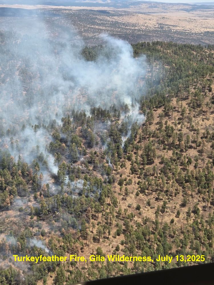
The Turkeyfeather Fire in the Gila Wilderness, NM has burned as a low-severity fire over about 24,000 acres (so far). This is a continuation of a fire regime that existed for millennia before the 20th century. This 🧵reviews the fire history of the Gila, as my colleagues and I have studied it. 1/18
July 20, 2025 at 1:36 PM
The Turkeyfeather Fire in the Gila Wilderness, NM has burned as a low-severity fire over about 24,000 acres (so far). This is a continuation of a fire regime that existed for millennia before the 20th century. This 🧵reviews the fire history of the Gila, as my colleagues and I have studied it. 1/18
Consecutive-year fire scars on a ponderosa pine from the Chuska Mtns, AZ. This is a rare occurrence within trees in the SW, but more common in central AZ where ignitions were added by Western Apache. Likewise, multiple examples of every-other-year fire scars within trees. #FireScarFriday (belated)

February 8, 2025 at 4:47 PM
Consecutive-year fire scars on a ponderosa pine from the Chuska Mtns, AZ. This is a rare occurrence within trees in the SW, but more common in central AZ where ignitions were added by Western Apache. Likewise, multiple examples of every-other-year fire scars within trees. #FireScarFriday (belated)