


FireMap.live
@firemap.bsky.social
Real-wildfire data at your fingertips 🌍 | Visualize global wildfire activity instantly 🔥 | Bushfire Map | #GeoINT #GeoAI| Currently in Beta
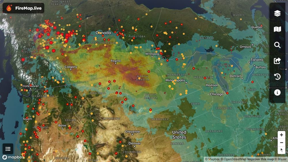
🌬️ Smoke Alert: Ever wonder how wildfire smoke travels so far? Right now, smoke from Alberta & BC wildfires stretches across the Prairies, affecting Calgary & Edmonton, and reaching as far as Chicago & Toronto. Hourly monitoring available now on FireMap
June 11, 2025 at 4:44 PM
🌬️ Smoke Alert: Ever wonder how wildfire smoke travels so far? Right now, smoke from Alberta & BC wildfires stretches across the Prairies, affecting Calgary & Edmonton, and reaching as far as Chicago & Toronto. Hourly monitoring available now on FireMap
Absolutely—tracking these fires is challenging. We've linked authoritative data with real-time satellite sensors on FireMap.live, letting you quickly pinpoint which fires are most active, boundary-free. Stay informed and safe! 🔥🛰️🌎
May 30, 2025 at 8:40 PM
Absolutely—tracking these fires is challenging. We've linked authoritative data with real-time satellite sensors on FireMap.live, letting you quickly pinpoint which fires are most active, boundary-free. Stay informed and safe! 🔥🛰️🌎
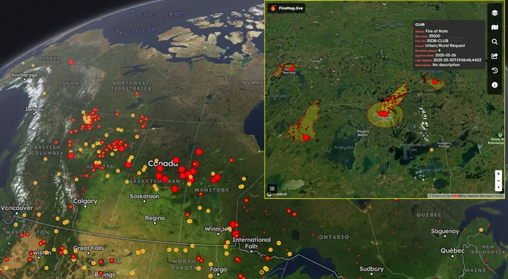
Wildfires continue to significantly impact communities across Canada, particularly in Manitoba, Alberta, and Saskatchewan. FireMap provides real-time satellite data and boundary-free tracking, offering critical insights for emergency responders and affected communities.
📍 Explore now: FireMap.live
📍 Explore now: FireMap.live
May 30, 2025 at 8:35 PM
Wildfires continue to significantly impact communities across Canada, particularly in Manitoba, Alberta, and Saskatchewan. FireMap provides real-time satellite data and boundary-free tracking, offering critical insights for emergency responders and affected communities.
📍 Explore now: FireMap.live
📍 Explore now: FireMap.live
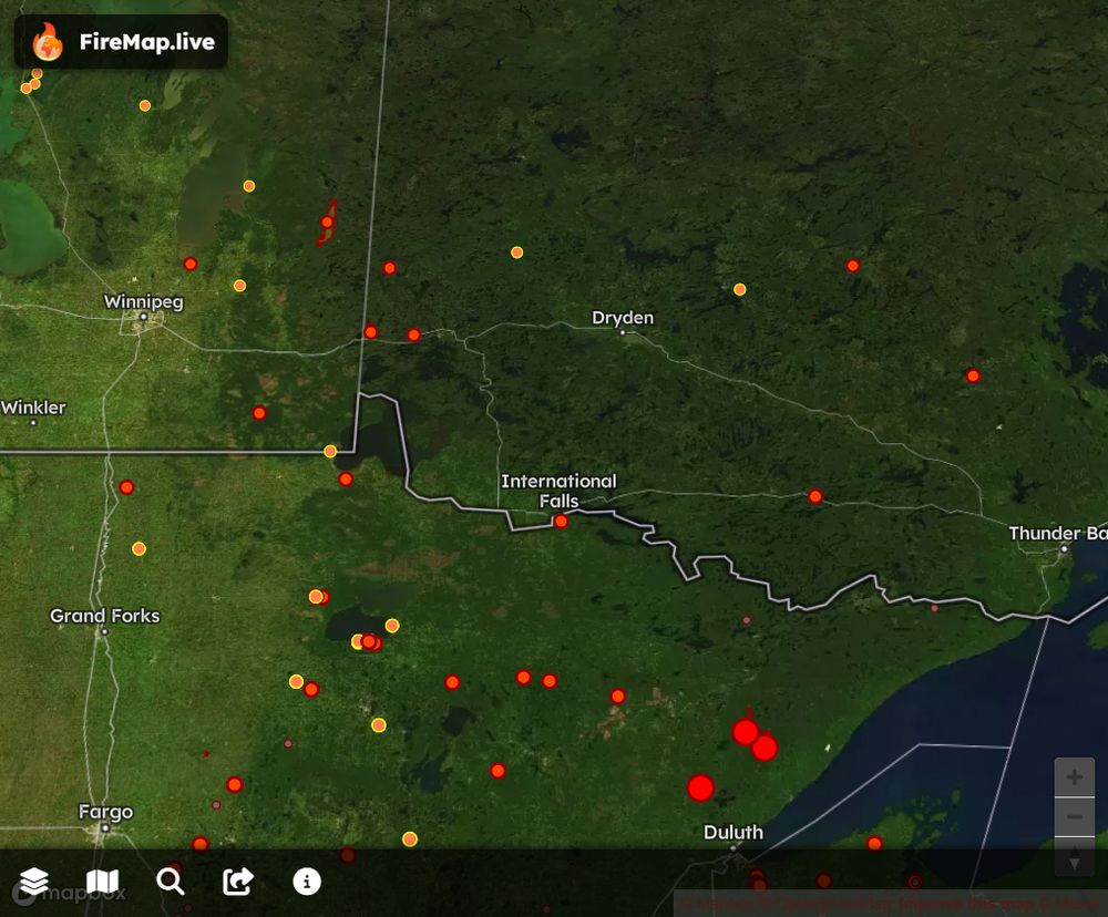
Feel fire to check FireMap for satellite hotspots and burned area boundary updates.
firemap.live?lng=-93.4505...
firemap.live?lng=-93.4505...
May 13, 2025 at 10:25 PM
Feel fire to check FireMap for satellite hotspots and burned area boundary updates.
firemap.live?lng=-93.4505...
firemap.live?lng=-93.4505...
When your friend catches a lava fountain on his birthday… shout out to Scott Malis for this insane Kīlauea footage. Volcano gods delivered 🔥🌋
April 3, 2025 at 1:36 AM
When your friend catches a lava fountain on his birthday… shout out to Scott Malis for this insane Kīlauea footage. Volcano gods delivered 🔥🌋
Table Rock, Persimmon Ridge, Big Ridge—& countless others. Wildfires are raging across the Carolinas & Georgia NOW. FireMap.live gives you live satellite hotspots & epic 3D views. We’ve got every blaze here—and worldwide—covered. Watch, share, stay alert—see FireMap
March 28, 2025 at 8:36 PM
Table Rock, Persimmon Ridge, Big Ridge—& countless others. Wildfires are raging across the Carolinas & Georgia NOW. FireMap.live gives you live satellite hotspots & epic 3D views. We’ve got every blaze here—and worldwide—covered. Watch, share, stay alert—see FireMap
A wildfire burning in Alpine National Park, west of Avon Wilderness Area and east of Licola, 200 miles northeast of Melbourne, Australia has reached 3,000+ acres. See the initial 3D boundaries on FireMap. Satellites detected 184 hotspots in the last 24 hours.
February 24, 2025 at 7:45 PM
A wildfire burning in Alpine National Park, west of Avon Wilderness Area and east of Licola, 200 miles northeast of Melbourne, Australia has reached 3,000+ acres. See the initial 3D boundaries on FireMap. Satellites detected 184 hotspots in the last 24 hours.
Wildfires in Northwestern Tasmania Australia🔥
Dry lightning has sparked multiple large fires in northwestern Tasmania, including the 8,000-hectare Yellowband Plain Fire and another near Canning Peak, closing the Overland Track. See FireMap.live for 3D burned area boundaries and real-time updates
Dry lightning has sparked multiple large fires in northwestern Tasmania, including the 8,000-hectare Yellowband Plain Fire and another near Canning Peak, closing the Overland Track. See FireMap.live for 3D burned area boundaries and real-time updates
February 11, 2025 at 11:29 PM
Wildfires in Northwestern Tasmania Australia🔥
Dry lightning has sparked multiple large fires in northwestern Tasmania, including the 8,000-hectare Yellowband Plain Fire and another near Canning Peak, closing the Overland Track. See FireMap.live for 3D burned area boundaries and real-time updates
Dry lightning has sparked multiple large fires in northwestern Tasmania, including the 8,000-hectare Yellowband Plain Fire and another near Canning Peak, closing the Overland Track. See FireMap.live for 3D burned area boundaries and real-time updates
Initial burn area boundary mapped for #LagunaFire near California State University Channel Islands campus in Ventura County. See #FireMap for updates
January 23, 2025 at 6:42 PM
Initial burn area boundary mapped for #LagunaFire near California State University Channel Islands campus in Ventura County. See #FireMap for updates
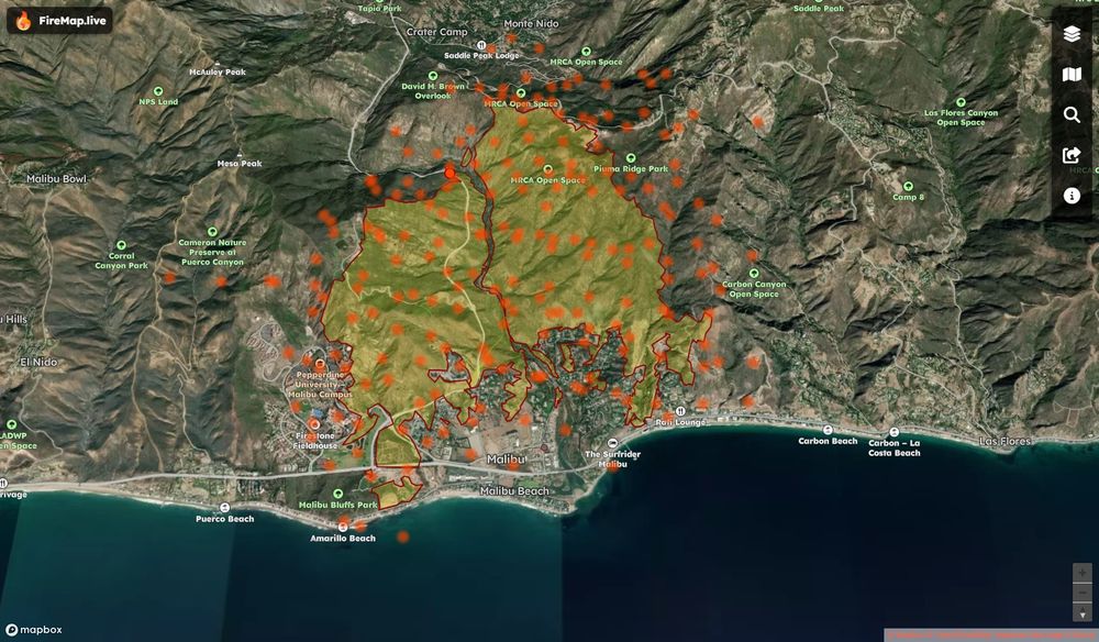
See 3D Franklin Fire Boundaries & Hotspots Mapped
-Malibu’s Franklin Fire Explodes: Residents Flee, Pepperdine Shelters in Place
#FranklinFire #MalibuFire #FireMap
-Malibu’s Franklin Fire Explodes: Residents Flee, Pepperdine Shelters in Place
#FranklinFire #MalibuFire #FireMap
December 10, 2024 at 6:43 PM
See 3D Franklin Fire Boundaries & Hotspots Mapped
-Malibu’s Franklin Fire Explodes: Residents Flee, Pepperdine Shelters in Place
#FranklinFire #MalibuFire #FireMap
-Malibu’s Franklin Fire Explodes: Residents Flee, Pepperdine Shelters in Place
#FranklinFire #MalibuFire #FireMap