


Fernando Primo Forgioni
@ferforgioni.bsky.social
Climate Scientist. Interested in Climate change and Atmospheric Teleconnections. Former Professor at UNVM 🇦🇷. Currently work on UFSM 🇧🇷
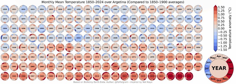
The COP30 is coming up, and a few months ago I made this chart for several countries (including Argentina) based on @berkeleyearth.org data. Like the rest of the planet, for much of the year we were above 1.5 degrees Celsius compared to the pre-industrial period (1850-1900).
November 4, 2025 at 10:13 PM
The COP30 is coming up, and a few months ago I made this chart for several countries (including Argentina) based on @berkeleyearth.org data. Like the rest of the planet, for much of the year we were above 1.5 degrees Celsius compared to the pre-industrial period (1850-1900).
I have three papers under review. I hope they all have minor revisions (please God hear my prayers 🙏🏻)

July 30, 2025 at 8:08 PM
I have three papers under review. I hope they all have minor revisions (please God hear my prayers 🙏🏻)
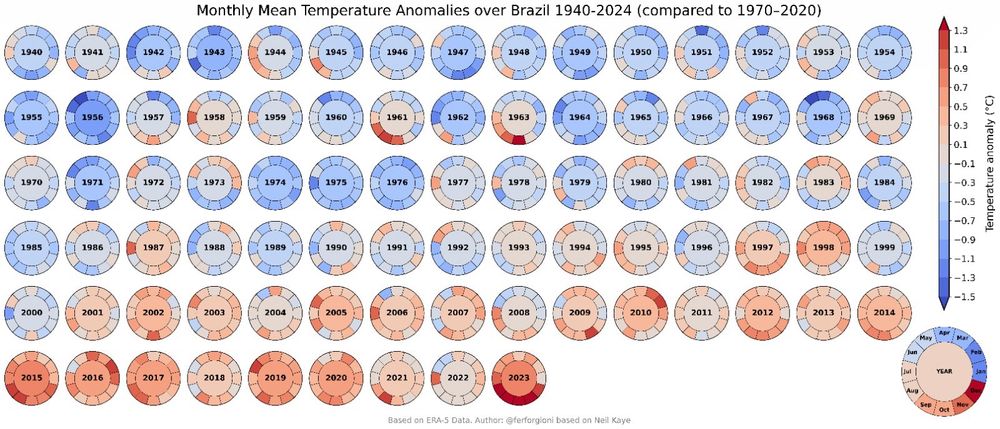
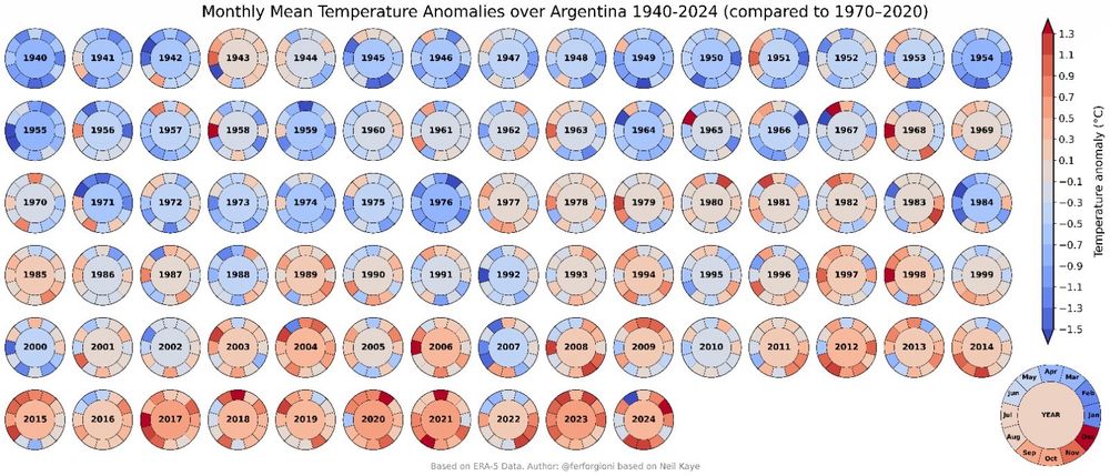
I take this idea from @neilrkaye.bsky.social (all credits go to him, i just adapt it). Using ERA5 data, the anomalies from 1940 to 2024 are shown for Brazil and Argentina. While the signal is not as robust as the global average, the influence of climate change on temperatures is evident.
March 21, 2025 at 6:51 AM
I take this idea from @neilrkaye.bsky.social (all credits go to him, i just adapt it). Using ERA5 data, the anomalies from 1940 to 2024 are shown for Brazil and Argentina. While the signal is not as robust as the global average, the influence of climate change on temperatures is evident.
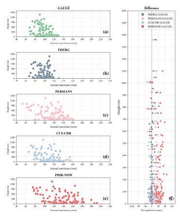
When graphing the probability distribution functions of each of the data sources, we see that IMERG is once again the one that best fits the distribution of observed data.

January 3, 2025 at 6:04 PM
When graphing the probability distribution functions of each of the data sources, we see that IMERG is once again the one that best fits the distribution of observed data.
Adding another layer of difficulty to the analysis, the difficulty of the satellites to represent precipitation extremes as altitude increased was also tested (orography is always a limitation in this type of data). Once again, IMERG takes the lead.
January 3, 2025 at 6:04 PM
Adding another layer of difficulty to the analysis, the difficulty of the satellites to represent precipitation extremes as altitude increased was also tested (orography is always a limitation in this type of data). Once again, IMERG takes the lead.
Here the scatter plots of the products and observed data show the same thing again. (Do not forget that these are extreme precipitation events, i.e. higher than the p95 of each location).

January 3, 2025 at 6:04 PM
Here the scatter plots of the products and observed data show the same thing again. (Do not forget that these are extreme precipitation events, i.e. higher than the p95 of each location).
Here you can see the correlation coefficients, bias, and root mean square error. While satellites have some major difficulties compared to daily data, the final IMERG Run V.06 product from NASA performs extremely well. Far above the others.

January 3, 2025 at 6:04 PM
Here you can see the correlation coefficients, bias, and root mean square error. While satellites have some major difficulties compared to daily data, the final IMERG Run V.06 product from NASA performs extremely well. Far above the others.
Continuing previous work (where we validated daily data: (rmets.onlinelibrary.wiley.com/doi/10.1002/... ) we used these 4 satellite products.

January 3, 2025 at 6:04 PM
Continuing previous work (where we validated daily data: (rmets.onlinelibrary.wiley.com/doi/10.1002/... ) we used these 4 satellite products.
The region chosen was the Southeast of South America. Again, 120 observation stations from different official organism from Argentina, Uruguay, Brazil and Paraguay were used. (C) average annual precipitation and (d) maximum precipitation recorded in 1 day.

January 3, 2025 at 6:04 PM
The region chosen was the Southeast of South America. Again, 120 observation stations from different official organism from Argentina, Uruguay, Brazil and Paraguay were used. (C) average annual precipitation and (d) maximum precipitation recorded in 1 day.
Line of instability associated with the passage of a cold front, reaching the border of Uruguay and Brazil. Causing severe storms. This record was near 21:00 UTC
December 2, 2024 at 3:22 AM
Line of instability associated with the passage of a cold front, reaching the border of Uruguay and Brazil. Causing severe storms. This record was near 21:00 UTC
It is amazing that most works on future projections of climate change or compound events only uses the most pessimistic emissions scenario. It is good to have “good” results, but it is limiting the view of the future too much
Me as a reviewer…
Me as a reviewer…
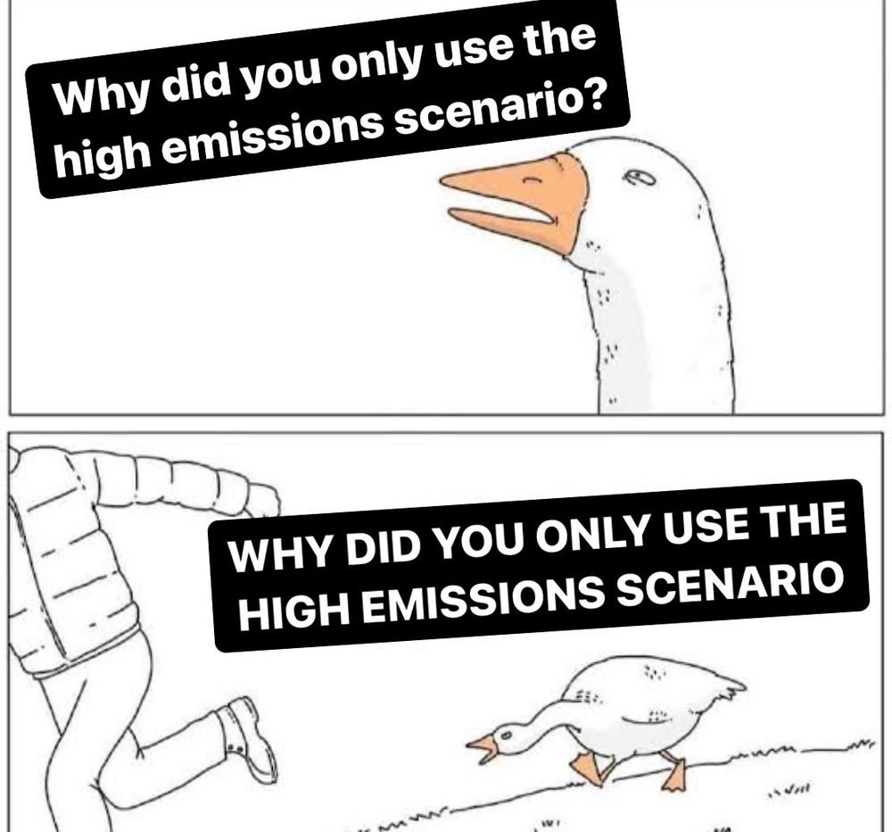
December 1, 2024 at 1:49 AM
It is amazing that most works on future projections of climate change or compound events only uses the most pessimistic emissions scenario. It is good to have “good” results, but it is limiting the view of the future too much
Me as a reviewer…
Me as a reviewer…
Thank you YESS community for this invitation. These spaces for conversation are necessary in view of the next COP29. So that we understand where the discussions are going and how we can take part in them. Demanding stronger and more real commitments.

November 1, 2024 at 7:25 PM
Thank you YESS community for this invitation. These spaces for conversation are necessary in view of the next COP29. So that we understand where the discussions are going and how we can take part in them. Demanding stronger and more real commitments.
In extreme drought conditions, aerosols are deposited and travel long distances transported by this mechanism. Depending on the synoptic conditions, they penetrate further south or east of the continent.


October 22, 2024 at 12:45 AM
In extreme drought conditions, aerosols are deposited and travel long distances transported by this mechanism. Depending on the synoptic conditions, they penetrate further south or east of the continent.
These aerosols can be dispersed over large regions transported by circulation mechanisms such as the South American low-level jet, causing serious impacts on populations. And reaching very remote places like Buenos Aires in Argentina

October 22, 2024 at 12:42 AM
These aerosols can be dispersed over large regions transported by circulation mechanisms such as the South American low-level jet, causing serious impacts on populations. And reaching very remote places like Buenos Aires in Argentina
Sadly, not only Brazil but all of South America has a “season” of fires. Mainly associated with practices such as fires started by farmers to create space for livestock.

October 22, 2024 at 12:32 AM
Sadly, not only Brazil but all of South America has a “season” of fires. Mainly associated with practices such as fires started by farmers to create space for livestock.
The occurrence of fires in Brazil is nothing new. Prolonged drought conditions in much of the north of the country have caused havoc in the already hard-hit Amazon region.

October 22, 2024 at 12:28 AM
The occurrence of fires in Brazil is nothing new. Prolonged drought conditions in much of the north of the country have caused havoc in the already hard-hit Amazon region.
Tomorrow we will have our workshop on wildfires ocurrence and the main circulation mechanisms associated with aerosol transport over long distances. This project brought us important cooperation between France, Argentina, Brazil and Peru.
I am very excited to share these results.
I am very excited to share these results.

October 22, 2024 at 12:25 AM
Tomorrow we will have our workshop on wildfires ocurrence and the main circulation mechanisms associated with aerosol transport over long distances. This project brought us important cooperation between France, Argentina, Brazil and Peru.
I am very excited to share these results.
I am very excited to share these results.
Our last paper is out!, which includes a careful spatial analysis in the interpolation...
#Niño/#Niña do not correlate equally in much of the agricultural production region of #Argentina Link: authors.elsevier.com/a/1jyDFB8cdOWYk
#Niño/#Niña do not correlate equally in much of the agricultural production region of #Argentina Link: authors.elsevier.com/a/1jyDFB8cdOWYk

October 21, 2024 at 5:30 AM
Our last paper is out!, which includes a careful spatial analysis in the interpolation...
#Niño/#Niña do not correlate equally in much of the agricultural production region of #Argentina Link: authors.elsevier.com/a/1jyDFB8cdOWYk
#Niño/#Niña do not correlate equally in much of the agricultural production region of #Argentina Link: authors.elsevier.com/a/1jyDFB8cdOWYk