


Efpeel
@efpeel.bsky.social
Geophysicist, working on CCUS projects.
The "Hunneschans" (Gelderland) is thought to be linked to 10th century AD iron production under control of the counts of Hamaland.
Archaeological finds (flint tools and burial mounts) are mainly from the Late Mesolithic and Mid-Neolithic, with limited finds from later periods.
#hillfortswednesday
Archaeological finds (flint tools and burial mounts) are mainly from the Late Mesolithic and Mid-Neolithic, with limited finds from later periods.
#hillfortswednesday

December 10, 2025 at 4:31 PM
The "Hunneschans" (Gelderland) is thought to be linked to 10th century AD iron production under control of the counts of Hamaland.
Archaeological finds (flint tools and burial mounts) are mainly from the Late Mesolithic and Mid-Neolithic, with limited finds from later periods.
#hillfortswednesday
Archaeological finds (flint tools and burial mounts) are mainly from the Late Mesolithic and Mid-Neolithic, with limited finds from later periods.
#hillfortswednesday
On this #HillfortsWednesday not a hillfort
sensu stricto, but a site that shows the ritual landscape of an Norwegian ironage burial site. At the Hå site a slope runs up a slope from the paleo-shoreline (indicated by red line) to a series of boat- or star shaped burial mounds.
snl.no/H%C3%A5_-_ar...
sensu stricto, but a site that shows the ritual landscape of an Norwegian ironage burial site. At the Hå site a slope runs up a slope from the paleo-shoreline (indicated by red line) to a series of boat- or star shaped burial mounds.
snl.no/H%C3%A5_-_ar...

December 3, 2025 at 1:53 PM
On this #HillfortsWednesday not a hillfort
sensu stricto, but a site that shows the ritual landscape of an Norwegian ironage burial site. At the Hå site a slope runs up a slope from the paleo-shoreline (indicated by red line) to a series of boat- or star shaped burial mounds.
snl.no/H%C3%A5_-_ar...
sensu stricto, but a site that shows the ritual landscape of an Norwegian ironage burial site. At the Hå site a slope runs up a slope from the paleo-shoreline (indicated by red line) to a series of boat- or star shaped burial mounds.
snl.no/H%C3%A5_-_ar...
Reposted by Efpeel

#Oops: The seminal paper that has been used for 25 years to justify that the use of #Glyphosate is safe has been retracted.
▶️ www.sciencedirect.com/science/arti...
"Concerns were raised regarding the authorship of this paper, validity of the research findings…"
▶️ www.sciencedirect.com/science/arti...
"Concerns were raised regarding the authorship of this paper, validity of the research findings…"

December 1, 2025 at 1:11 PM
#Oops: The seminal paper that has been used for 25 years to justify that the use of #Glyphosate is safe has been retracted.
▶️ www.sciencedirect.com/science/arti...
"Concerns were raised regarding the authorship of this paper, validity of the research findings…"
▶️ www.sciencedirect.com/science/arti...
"Concerns were raised regarding the authorship of this paper, validity of the research findings…"
Reposted by Efpeel

We have upgraded our geomagnetic forecast today (12 November 2025) to the highest intensity level amid an ongoing solar storm.
Current predictions suggest that the activity will result in potentially the largest solar storm to hit our planet in over two decades.
Current predictions suggest that the activity will result in potentially the largest solar storm to hit our planet in over two decades.
November 12, 2025 at 2:55 PM
We have upgraded our geomagnetic forecast today (12 November 2025) to the highest intensity level amid an ongoing solar storm.
Current predictions suggest that the activity will result in potentially the largest solar storm to hit our planet in over two decades.
Current predictions suggest that the activity will result in potentially the largest solar storm to hit our planet in over two decades.
In the Netherlands when people contemplate climate impact they tend to look out to the sea, or over their shoulders to the rivers. It may be prudent though to start looking at the sky!

November 9, 2025 at 12:28 PM
In the Netherlands when people contemplate climate impact they tend to look out to the sea, or over their shoulders to the rivers. It may be prudent though to start looking at the sky!
In 1976 Courtillot and Le Mouël [1] noted the occurrence of geomagnetic jerks. A jerk is a relative sudden change in the 2nd derivative of the geomagnetic field with respect to time.
If such a behaviour would occur in a time series, what would be an appropriate statistical method to detect it?
If such a behaviour would occur in a time series, what would be an appropriate statistical method to detect it?

September 30, 2025 at 12:33 PM
In 1976 Courtillot and Le Mouël [1] noted the occurrence of geomagnetic jerks. A jerk is a relative sudden change in the 2nd derivative of the geomagnetic field with respect to time.
If such a behaviour would occur in a time series, what would be an appropriate statistical method to detect it?
If such a behaviour would occur in a time series, what would be an appropriate statistical method to detect it?
Amazing that this became so relevant 2 months later!
(Left) Illustration from The Ladies' home journal (1948) by Albert Dorne. (Middle) Still from "Real Snow White" a short video by the award winning Finnish performance artist Pilve Takala
(Right) Television series "The Handmaid's Tale"
pilvitakala.com/real-snow-wh...
tinyurl.com/pilviRSW
(Right) Television series "The Handmaid's Tale"
pilvitakala.com/real-snow-wh...
tinyurl.com/pilviRSW

September 21, 2025 at 3:48 PM
Amazing that this became so relevant 2 months later!
In the June New Scientist (https://tinyurl.com/botanyone), paleobiologist Colin Barras reports that there's growing evidence that the big five mass extinctions may, for plants at least, never have happened. This would put us in unchartered territory with the current biodiversity loss. (1/4)
August 10, 2025 at 2:47 PM
In the June New Scientist (https://tinyurl.com/botanyone), paleobiologist Colin Barras reports that there's growing evidence that the big five mass extinctions may, for plants at least, never have happened. This would put us in unchartered territory with the current biodiversity loss. (1/4)
(Left) Illustration from The Ladies' home journal (1948) by Albert Dorne. (Middle) Still from "Real Snow White" a short video by the award winning Finnish performance artist Pilve Takala
(Right) Television series "The Handmaid's Tale"
pilvitakala.com/real-snow-wh...
tinyurl.com/pilviRSW
(Right) Television series "The Handmaid's Tale"
pilvitakala.com/real-snow-wh...
tinyurl.com/pilviRSW
July 23, 2025 at 11:47 AM
(Left) Illustration from The Ladies' home journal (1948) by Albert Dorne. (Middle) Still from "Real Snow White" a short video by the award winning Finnish performance artist Pilve Takala
(Right) Television series "The Handmaid's Tale"
pilvitakala.com/real-snow-wh...
tinyurl.com/pilviRSW
(Right) Television series "The Handmaid's Tale"
pilvitakala.com/real-snow-wh...
tinyurl.com/pilviRSW
🧪⚒️Google AI: Are you serious??? Two screenshots of Google’s AI overview made minutes appart:

June 22, 2025 at 11:18 AM
🧪⚒️Google AI: Are you serious??? Two screenshots of Google’s AI overview made minutes appart:
**** NEW PAPER ALERT *****
Detection of CO2 distribution by seismic pulse width analysis using mollifier functions
issuu.com/eage/docs/fi...
Detection of CO2 distribution by seismic pulse width analysis using mollifier functions
issuu.com/eage/docs/fi...

First Break June 2025 - Navigating Change: Geosciences Shaping a Sustainable Transition
issuu.com
June 1, 2025 at 1:25 PM
**** NEW PAPER ALERT *****
Detection of CO2 distribution by seismic pulse width analysis using mollifier functions
issuu.com/eage/docs/fi...
Detection of CO2 distribution by seismic pulse width analysis using mollifier functions
issuu.com/eage/docs/fi...
Reposted by Efpeel
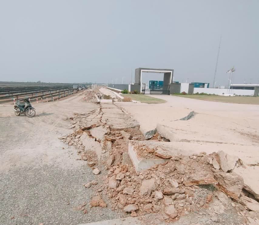
This is a photo of the surface rupture we saw in the webcam footage of the Myanmar #earthquake. The webcam was positioned on the opposite side behind the gate. Source is the YouTube channel that also posted the footage. 🧪⚒️
youtube.com/@sagaingeart...
youtube.com/@sagaingeart...
May 15, 2025 at 5:42 PM
This is a photo of the surface rupture we saw in the webcam footage of the Myanmar #earthquake. The webcam was positioned on the opposite side behind the gate. Source is the YouTube channel that also posted the footage. 🧪⚒️
youtube.com/@sagaingeart...
youtube.com/@sagaingeart...
🧪 ⚒️The location (red symbol) of the first ever footage of the fault rupture of the 2025 Sagaing #earthquake shows the Tharzi solar farm is right on top of the surface expression of the Meiktila segment recorded in 2000 by the Space Shuttle Topography Mission. Video: www.youtube.com/watch?v=77ub...

May 14, 2025 at 3:29 PM
🧪 ⚒️The location (red symbol) of the first ever footage of the fault rupture of the 2025 Sagaing #earthquake shows the Tharzi solar farm is right on top of the surface expression of the Meiktila segment recorded in 2000 by the Space Shuttle Topography Mission. Video: www.youtube.com/watch?v=77ub...
🧪⚒️ Comparison 23/4 #Turkey #earthquake foreshock (top) and main shock (middle/blue curve) recorded by station KCTX. The middle track also shows in red the foreshock matched to main shock with a short filter (bottom plot). The location of the recent quakes are shown coloured with magnitude.

May 3, 2025 at 9:58 AM
🧪⚒️ Comparison 23/4 #Turkey #earthquake foreshock (top) and main shock (middle/blue curve) recorded by station KCTX. The middle track also shows in red the foreshock matched to main shock with a short filter (bottom plot). The location of the recent quakes are shown coloured with magnitude.
Seismic arrivals of Myanmar earthquake @ Thailand stations plotted against distance. The onset strongest arrivals line up with Rayleigh wave arrival time apart from stations near Bangkok (PRAC & NAYO) where arrival is earlier.

March 31, 2025 at 1:19 PM
Seismic arrivals of Myanmar earthquake @ Thailand stations plotted against distance. The onset strongest arrivals line up with Rayleigh wave arrival time apart from stations near Bangkok (PRAC & NAYO) where arrival is earlier.
Those of you dumbfounded by the present attitude towards science should remember the sentiment voiced by 18th century French Revolutionary Marat: Science is to be guided by public opinion and mathematics to be suppressed because of “servile devotion to formulae”
- No Need for Geniuses (Steve Jones)
- No Need for Geniuses (Steve Jones)
March 23, 2025 at 11:37 AM
Those of you dumbfounded by the present attitude towards science should remember the sentiment voiced by 18th century French Revolutionary Marat: Science is to be guided by public opinion and mathematics to be suppressed because of “servile devotion to formulae”
- No Need for Geniuses (Steve Jones)
- No Need for Geniuses (Steve Jones)
The occurance of two earthquakes in rapid succession or along connected fault segments can increase the seismic hazard (Chaussard, et al. 2015: doi.org/10.1002/2015...).
Graves (2024) modelled a scenario for a 7.1 Moment Magnitude Calaveras Fault earthquake "Doublet". doi.org/10.5066/P1YK....
Graves (2024) modelled a scenario for a 7.1 Moment Magnitude Calaveras Fault earthquake "Doublet". doi.org/10.5066/P1YK....
March 4, 2025 at 4:34 PM
The occurance of two earthquakes in rapid succession or along connected fault segments can increase the seismic hazard (Chaussard, et al. 2015: doi.org/10.1002/2015...).
Graves (2024) modelled a scenario for a 7.1 Moment Magnitude Calaveras Fault earthquake "Doublet". doi.org/10.5066/P1YK....
Graves (2024) modelled a scenario for a 7.1 Moment Magnitude Calaveras Fault earthquake "Doublet". doi.org/10.5066/P1YK....
Experts interpret the #santorini earthquake swarm to be primarly caused by tectonic processes. One of the attributes to distinguish earthquakes associated with volcanisms from these tectonic processes is the distribution of earthquake magnitudes. (1/6)

February 8, 2025 at 3:49 PM
Experts interpret the #santorini earthquake swarm to be primarly caused by tectonic processes. One of the attributes to distinguish earthquakes associated with volcanisms from these tectonic processes is the distribution of earthquake magnitudes. (1/6)
Reposted by Efpeel
Earthquake activity offshore Santorini, Greece, imaged in high-resolution and processed by Marius Isken in our team at GFZ using github.com/pyrocko/qseek

February 6, 2025 at 6:10 AM
Earthquake activity offshore Santorini, Greece, imaged in high-resolution and processed by Marius Isken in our team at GFZ using github.com/pyrocko/qseek
🧪The #Santorini earthquake swarm is interpreted to be associated with normal fault (extension) earthquakes. These earthquakes are located along the Anhydros Fault which runs towards the NE away from Santorini. (1/5)

February 4, 2025 at 2:06 PM
🧪The #Santorini earthquake swarm is interpreted to be associated with normal fault (extension) earthquakes. These earthquakes are located along the Anhydros Fault which runs towards the NE away from Santorini. (1/5)
#santorini earthquakes are getting shallower, more often and more towards the NE since last month. Loci colour denotes depth.
Earthquake data from bbnet.gein.noa.gr real time catalogue.
Earthquake data from bbnet.gein.noa.gr real time catalogue.

February 3, 2025 at 5:05 PM
#santorini earthquakes are getting shallower, more often and more towards the NE since last month. Loci colour denotes depth.
Earthquake data from bbnet.gein.noa.gr real time catalogue.
Earthquake data from bbnet.gein.noa.gr real time catalogue.
The Mossy Tree by the enigmatic 17th century artist Hercules Segers. The tree is covered with Bearded Lichen which is an indicator of SO2 and NH3 pollution. In polluted areas they may grow no larger than a few millimetres, if they survive at all. In unpolluted areas, they can grow to 10–20 cm long.

December 28, 2024 at 7:50 AM
The Mossy Tree by the enigmatic 17th century artist Hercules Segers. The tree is covered with Bearded Lichen which is an indicator of SO2 and NH3 pollution. In polluted areas they may grow no larger than a few millimetres, if they survive at all. In unpolluted areas, they can grow to 10–20 cm long.
For the #geomorphology enthusiasts: A comparison between two #LIDAR vintages and a #photogrammetry made using a drone video showing the limitations of getting the steep walls with airborne lidar..
November 24, 2024 at 8:46 AM
For the #geomorphology enthusiasts: A comparison between two #LIDAR vintages and a #photogrammetry made using a drone video showing the limitations of getting the steep walls with airborne lidar..
The elevation map looking north towards Bonn shows earthquake surface locations that occurred in the past 25 years. The light colours indicate quakes at kilometres depth and the dark colours 10s of kilometres depth. The site of the 12900 year BP Laacher See eruption is highlighted in the black box.

November 9, 2024 at 1:29 PM
The elevation map looking north towards Bonn shows earthquake surface locations that occurred in the past 25 years. The light colours indicate quakes at kilometres depth and the dark colours 10s of kilometres depth. The site of the 12900 year BP Laacher See eruption is highlighted in the black box.
The #earthquakes recorded a month ago near the #Grindavik eruption plotted w.r.t. the fissure observed last night (red/yellow surface).
en.vedur.is/about-imo/ne...
en.vedur.is/about-imo/ne...

December 19, 2023 at 2:15 PM
The #earthquakes recorded a month ago near the #Grindavik eruption plotted w.r.t. the fissure observed last night (red/yellow surface).
en.vedur.is/about-imo/ne...
en.vedur.is/about-imo/ne...