


Eddie Sheerr
@eddiesheerr.bsky.social
Founder of Sheerr Weather | Digital Meteorologist | Newfoundland & Labrador, Canada
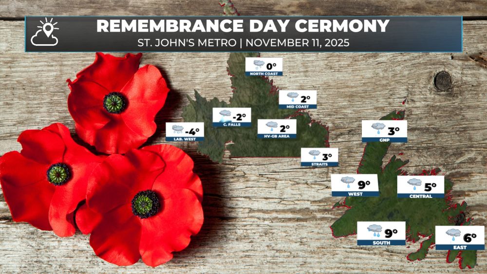
November 11, 2025 at 11:27 AM
RAIN AND SNOW AMOUNT CHARTS
These images will give you an idea of where the most rain and snow will fall over the next 48 or more hours. #nlwx
These images will give you an idea of where the most rain and snow will fall over the next 48 or more hours. #nlwx


November 10, 2025 at 2:05 PM
RAIN AND SNOW AMOUNT CHARTS
These images will give you an idea of where the most rain and snow will fall over the next 48 or more hours. #nlwx
These images will give you an idea of where the most rain and snow will fall over the next 48 or more hours. #nlwx
Today will be a good day to make any last-minute preparations before the next weather system arrives.
A developing area of low pressure located over eastern Long Island this morning will send rain into Newfoundland and snow into Labrador by this evening.
#nlwx
A developing area of low pressure located over eastern Long Island this morning will send rain into Newfoundland and snow into Labrador by this evening.
#nlwx
November 10, 2025 at 10:21 AM
Today will be a good day to make any last-minute preparations before the next weather system arrives.
A developing area of low pressure located over eastern Long Island this morning will send rain into Newfoundland and snow into Labrador by this evening.
#nlwx
A developing area of low pressure located over eastern Long Island this morning will send rain into Newfoundland and snow into Labrador by this evening.
#nlwx
Some flakes have been spotted on Kenmount Road, near the border of St. John's and Paradise. #nlwx #nltraffic

November 6, 2025 at 9:07 PM
Some flakes have been spotted on Kenmount Road, near the border of St. John's and Paradise. #nlwx #nltraffic
Some tidal flooding on the go this morning in the Placentia / Danville areas.
📸 Vanessa Mooney | NOV 6, 2025
📸 Vanessa Mooney | NOV 6, 2025


November 6, 2025 at 2:26 PM
Some tidal flooding on the go this morning in the Placentia / Danville areas.
📸 Vanessa Mooney | NOV 6, 2025
📸 Vanessa Mooney | NOV 6, 2025
The wind is still howling around the intense low located north of the Island. Central pressure up to 952 mb, which is higher than it was as it crossed Newfoundland last night. #nlwx


November 5, 2025 at 9:47 AM
The wind is still howling around the intense low located north of the Island. Central pressure up to 952 mb, which is higher than it was as it crossed Newfoundland last night. #nlwx
The radar shows our record-breaking November low swirling over eastern Newfoundland this evening. Pretty wild to see, even from my chair! #nlwx
NOV 4, 2025 | 10:17 PM NST
NOV 4, 2025 | 10:17 PM NST
November 5, 2025 at 1:48 AM
The radar shows our record-breaking November low swirling over eastern Newfoundland this evening. Pretty wild to see, even from my chair! #nlwx
NOV 4, 2025 | 10:17 PM NST
NOV 4, 2025 | 10:17 PM NST
Private weather stations on the southern Avalon at Cape St. Mary's and Powles Head Lighthouse are measuring gusts well over Hurricane-force this evening!
NOV 4, 2025 | 6:04 PM
#nlwx
NOV 4, 2025 | 6:04 PM
#nlwx

November 4, 2025 at 9:36 PM
Private weather stations on the southern Avalon at Cape St. Mary's and Powles Head Lighthouse are measuring gusts well over Hurricane-force this evening!
NOV 4, 2025 | 6:04 PM
#nlwx
NOV 4, 2025 | 6:04 PM
#nlwx
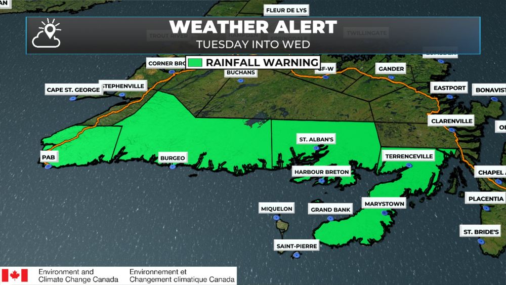
SNOWFALL WARNING ISSUED
NOV 4, 2025 | 5:37 PM NST
A Snowfall Warning has been issued for central and western Newfoundland for tonight. Up to 20 cm of snow is expected over higher terrain. Less will be found in the lower elevations. Rain should be falling near the coast. #nlwx
NOV 4, 2025 | 5:37 PM NST
A Snowfall Warning has been issued for central and western Newfoundland for tonight. Up to 20 cm of snow is expected over higher terrain. Less will be found in the lower elevations. Rain should be falling near the coast. #nlwx

November 4, 2025 at 9:09 PM
SNOWFALL WARNING ISSUED
NOV 4, 2025 | 5:37 PM NST
A Snowfall Warning has been issued for central and western Newfoundland for tonight. Up to 20 cm of snow is expected over higher terrain. Less will be found in the lower elevations. Rain should be falling near the coast. #nlwx
NOV 4, 2025 | 5:37 PM NST
A Snowfall Warning has been issued for central and western Newfoundland for tonight. Up to 20 cm of snow is expected over higher terrain. Less will be found in the lower elevations. Rain should be falling near the coast. #nlwx


Various Coastal Flooding Alerts are in effect for NL, and additional alerts have been issued. I'm most concerned about the southern and southeast Avalon when it comes to the high tide this evening. #nlwx
Updated alerts: weather.gc.ca?layers=alert...
Updated alerts: weather.gc.ca?layers=alert...


November 4, 2025 at 10:39 AM
Various Coastal Flooding Alerts are in effect for NL, and additional alerts have been issued. I'm most concerned about the southern and southeast Avalon when it comes to the high tide this evening. #nlwx
Updated alerts: weather.gc.ca?layers=alert...
Updated alerts: weather.gc.ca?layers=alert...
Here is an animation of how the wind gusts are expected to play out from tomorrow morning (November 4, 2025) through Wednesday.
Some areas of southern and eastern Newfoundland will see the wind peak twice. Once tomorrow afternoon/evening and again early Wednesday morning.
#nlwx
Some areas of southern and eastern Newfoundland will see the wind peak twice. Once tomorrow afternoon/evening and again early Wednesday morning.
#nlwx
November 3, 2025 at 8:54 PM
Here is an animation of how the wind gusts are expected to play out from tomorrow morning (November 4, 2025) through Wednesday.
Some areas of southern and eastern Newfoundland will see the wind peak twice. Once tomorrow afternoon/evening and again early Wednesday morning.
#nlwx
Some areas of southern and eastern Newfoundland will see the wind peak twice. Once tomorrow afternoon/evening and again early Wednesday morning.
#nlwx
Wind Warnings are now in effect for much of coastal Newfoundland from tomorrow into Wed for gusts as high as 100 km/h (locally higher).
A Rainfall Warning is now in effect from the Burin Peninsula to PAB for an amount of 50+ mm between tomorrow and late Wed.
#nlwx
A Rainfall Warning is now in effect from the Burin Peninsula to PAB for an amount of 50+ mm between tomorrow and late Wed.
#nlwx

November 3, 2025 at 8:20 PM
Wind Warnings are now in effect for much of coastal Newfoundland from tomorrow into Wed for gusts as high as 100 km/h (locally higher).
A Rainfall Warning is now in effect from the Burin Peninsula to PAB for an amount of 50+ mm between tomorrow and late Wed.
#nlwx
A Rainfall Warning is now in effect from the Burin Peninsula to PAB for an amount of 50+ mm between tomorrow and late Wed.
#nlwx
A Wind Warning has been issued for Tuesday afternoon through midday Wednesday time frame by @ECCCWeatherNL. #nlwx
The alert states that winds will gust as high as 110 km/h on Tuesday afternoon and may exceed 100 km/h on Tuesday night. Winds will gradually diminish on Wed.
The alert states that winds will gust as high as 110 km/h on Tuesday afternoon and may exceed 100 km/h on Tuesday night. Winds will gradually diminish on Wed.

November 3, 2025 at 10:35 AM
A Wind Warning has been issued for Tuesday afternoon through midday Wednesday time frame by @ECCCWeatherNL. #nlwx
The alert states that winds will gust as high as 110 km/h on Tuesday afternoon and may exceed 100 km/h on Tuesday night. Winds will gradually diminish on Wed.
The alert states that winds will gust as high as 110 km/h on Tuesday afternoon and may exceed 100 km/h on Tuesday night. Winds will gradually diminish on Wed.
This animation shows the wind core associated with Hurricane/Post-Tropical Storm Melissa. As long as we don't get a dramatic shift in the track, the hurricane-force gusts (120+ km/h) remain offshore. #nlwx
October 30, 2025 at 7:31 PM
This animation shows the wind core associated with Hurricane/Post-Tropical Storm Melissa. As long as we don't get a dramatic shift in the track, the hurricane-force gusts (120+ km/h) remain offshore. #nlwx
Furthermore, significant rain is likely over other areas of the Island from later Friday into Saturday, driven by a separate weather-maker. #nlwx (3/3)

October 30, 2025 at 11:31 AM
Furthermore, significant rain is likely over other areas of the Island from later Friday into Saturday, driven by a separate weather-maker. #nlwx (3/3)
Current forecasts continue to indicate the centre of the storm will pass over the east Avalon or offshore. While this track will not eliminate winds completely, the highest wind gusts (120+ km/h) remain offshore. Significant rain is likely. #nlwx (2/3)

October 30, 2025 at 11:31 AM
Current forecasts continue to indicate the centre of the storm will pass over the east Avalon or offshore. While this track will not eliminate winds completely, the highest wind gusts (120+ km/h) remain offshore. Significant rain is likely. #nlwx (2/3)


🧵 Forecasts for Hurricane Melissa have started to trend northwest, and the centre of the storm is now forecast to be close enough to the Avalon that direct impacts for portions of Newfoundland between late Friday evening and Saturday morning look more likely. #nlwx (1/7)

October 29, 2025 at 1:25 PM
🧵 Forecasts for Hurricane Melissa have started to trend northwest, and the centre of the storm is now forecast to be close enough to the Avalon that direct impacts for portions of Newfoundland between late Friday evening and Saturday morning look more likely. #nlwx (1/7)
Over 500 mm of rain will fall across parts of Jamaica between tonight and late Tuesday night or early Wednesday morning (October 27-29, 2025) from Hurricane #Melissa.
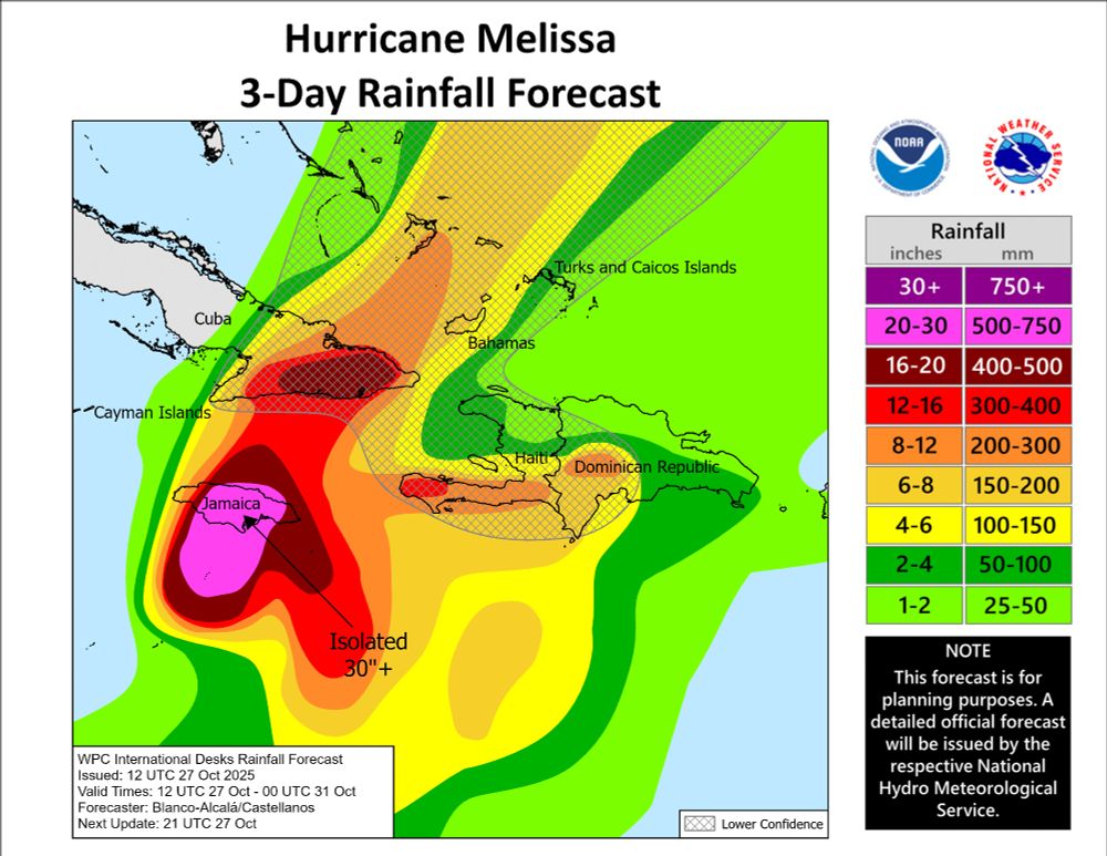
October 27, 2025 at 4:50 PM
Over 500 mm of rain will fall across parts of Jamaica between tonight and late Tuesday night or early Wednesday morning (October 27-29, 2025) from Hurricane #Melissa.
Good Friday morning! Heavy rain will fall on the Avalon Peninsula today. Rainfall Warnings are in effect for southern areas, where over 50 mm of rain is expected by tomorrow. #nlwx
October 24, 2025 at 8:33 AM
Good Friday morning! Heavy rain will fall on the Avalon Peninsula today. Rainfall Warnings are in effect for southern areas, where over 50 mm of rain is expected by tomorrow. #nlwx
Heavy rain is looking VERY likely over the Avalon and possibly the Burin Peninsulas from late Thursday into Saturday. Computer guidance, as of late Wednesday evening, suggests there is a 90 to 100% chance that most of this area sees more than 25 mm of rain. Details to follow! #nlwx

October 23, 2025 at 1:47 AM
Heavy rain is looking VERY likely over the Avalon and possibly the Burin Peninsulas from late Thursday into Saturday. Computer guidance, as of late Wednesday evening, suggests there is a 90 to 100% chance that most of this area sees more than 25 mm of rain. Details to follow! #nlwx
We are going to see another day of warm (for late October) temperatures across NL. Additionally, there will be some showers across the board, with areas of rain expected later today over parts of southeastern Newfoundland. Details in the link below! #nlwx
buff.ly/FVNBoAa
buff.ly/FVNBoAa

October 22, 2025 at 8:42 AM
We are going to see another day of warm (for late October) temperatures across NL. Additionally, there will be some showers across the board, with areas of rain expected later today over parts of southeastern Newfoundland. Details in the link below! #nlwx
buff.ly/FVNBoAa
buff.ly/FVNBoAa
