


David Roth
@drmetwatch.bsky.social
Meteorologist. Into weather records. Soft spot for subtropical 🌀. 😻 and nature imagery, too.
Interesting convective feature north of the Leewards

November 18, 2025 at 9:18 PM
Interesting convective feature north of the Leewards
This time as a .png…

November 14, 2025 at 2:10 AM
This time as a .png…
Progress has been made. Seven state climatologists accept their state’s readings. Still waiting to hear back from numerous others. 🐻⌚️
November 14, 2025 at 1:34 AM
Progress has been made. Seven state climatologists accept their state’s readings. Still waiting to hear back from numerous others. 🐻⌚️
Disturbed weather continues to exist near Central America near the tail end of a front.

November 13, 2025 at 2:01 PM
Disturbed weather continues to exist near Central America near the tail end of a front.
A local Maryland Dwarf Holly has berries now.

November 9, 2025 at 3:31 PM
A local Maryland Dwarf Holly has berries now.
Our first pre 5pm sunset here. It recedes to 4:45 in early December before returning to 5pm January 5.

November 9, 2025 at 3:13 PM
Our first pre 5pm sunset here. It recedes to 4:45 in early December before returning to 5pm January 5.
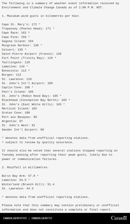
From Environment Canada. Relayed by @cyclone-fogarty.bsky.social. :)

November 5, 2025 at 6:54 PM
From Environment Canada. Relayed by @cyclone-fogarty.bsky.social. :)
Bumper crop of vultures at Hughes in Gburg. It’s still unclear if they’re using the windows for their reflection or hunting something up there. ¯\_(ツ)_/¯

November 5, 2025 at 4:06 PM
Bumper crop of vultures at Hughes in Gburg. It’s still unclear if they’re using the windows for their reflection or hunting something up there. ¯\_(ツ)_/¯
The 00z surface analysis. 944 hPa central pressure. There was a 944.7 hPa observation from Marticot Island at 23z.

November 5, 2025 at 2:48 AM
The 00z surface analysis. 944 hPa central pressure. There was a 944.7 hPa observation from Marticot Island at 23z.
Many Canadian observations keep dropping pressure — probably a QC flag in the MSLP and/or altimeter reading. This cyclone would realistically set November low pressure records for the southeast half of the island. They’re not that low.
The absolute low pressure for the island remains 940.2 hPa.
The absolute low pressure for the island remains 940.2 hPa.

November 4, 2025 at 9:26 PM
Many Canadian observations keep dropping pressure — probably a QC flag in the MSLP and/or altimeter reading. This cyclone would realistically set November low pressure records for the southeast half of the island. They’re not that low.
The absolute low pressure for the island remains 940.2 hPa.
The absolute low pressure for the island remains 940.2 hPa.
St. Pierre, in “oceanic France” just south of Newfoundland, dropped to 946 hPa as this cyclone passed by at 5pm their time (2000 UTC).
They do not seem to be part of the “funky” Newfoundland time zone.
They do not seem to be part of the “funky” Newfoundland time zone.


November 4, 2025 at 8:41 PM
St. Pierre, in “oceanic France” just south of Newfoundland, dropped to 946 hPa as this cyclone passed by at 5pm their time (2000 UTC).
They do not seem to be part of the “funky” Newfoundland time zone.
They do not seem to be part of the “funky” Newfoundland time zone.
Disturbed weather moving west-northwest through the northwest Caribbean.

November 4, 2025 at 6:12 PM
Disturbed weather moving west-northwest through the northwest Caribbean.
Sometimes when you go to take a fall foliage picture, it reverses on you. ¯\_(ツ)_/¯

November 3, 2025 at 7:16 PM
Sometimes when you go to take a fall foliage picture, it reverses on you. ¯\_(ツ)_/¯

Our pair of cyclones continue. Melissa is the eastern one. It clipped Cape Race last night.

November 1, 2025 at 9:59 PM
Our pair of cyclones continue. Melissa is the eastern one. It clipped Cape Race last night.
Fun times. Notice the unnamed storm — which was cold core — didn’t impact their TS count. 🐻⌚️

October 31, 2025 at 9:11 PM
Fun times. Notice the unnamed storm — which was cold core — didn’t impact their TS count. 🐻⌚️
While Post-T.C. Melissa remains hurricane-force well offshore the East Coast this morning, a cyclone nearly as deep continues to strengthen near the border of New England with southeast Canada.

October 31, 2025 at 2:57 PM
While Post-T.C. Melissa remains hurricane-force well offshore the East Coast this morning, a cyclone nearly as deep continues to strengthen near the border of New England with southeast Canada.
Extratropical transition is clearly beginning. Vertical wind shear has increased. Interaction with the upper trough to the west has begun. Melissa’s moisture has reached New England as well. The storm could be post-tropical in 24 hours. 🐻⌚️

October 30, 2025 at 8:13 PM
Extratropical transition is clearly beginning. Vertical wind shear has increased. Interaction with the upper trough to the west has begun. Melissa’s moisture has reached New England as well. The storm could be post-tropical in 24 hours. 🐻⌚️
The Cuba landfall is upon us

October 29, 2025 at 7:10 AM
The Cuba landfall is upon us
Melissa stopped on a dime and turned NNE.
The deluge is ongoing in Jamaica, with an intense feeder band aimed at Hispaniola; day 7 of rain there. Eastern Cuba should see its heaviest rain later today into tomorrow.
Water remains the deadliest hazard associated with tropical cyclones.
🐻⌚️
The deluge is ongoing in Jamaica, with an intense feeder band aimed at Hispaniola; day 7 of rain there. Eastern Cuba should see its heaviest rain later today into tomorrow.
Water remains the deadliest hazard associated with tropical cyclones.
🐻⌚️

October 28, 2025 at 3:07 PM
Melissa stopped on a dime and turned NNE.
The deluge is ongoing in Jamaica, with an intense feeder band aimed at Hispaniola; day 7 of rain there. Eastern Cuba should see its heaviest rain later today into tomorrow.
Water remains the deadliest hazard associated with tropical cyclones.
🐻⌚️
The deluge is ongoing in Jamaica, with an intense feeder band aimed at Hispaniola; day 7 of rain there. Eastern Cuba should see its heaviest rain later today into tomorrow.
Water remains the deadliest hazard associated with tropical cyclones.
🐻⌚️
Melissa moves west, south of western Jamaica. The guidance generally is too early to recurve, but also not sharp enough with recurvature. One would think we’d have a better idea of whether or not a Jamaica landfall was certain tonight. Either way, Jamaica will see significant impacts. 🌊. 🐻⌚️
October 27, 2025 at 4:44 PM
Melissa moves west, south of western Jamaica. The guidance generally is too early to recurve, but also not sharp enough with recurvature. One would think we’d have a better idea of whether or not a Jamaica landfall was certain tonight. Either way, Jamaica will see significant impacts. 🌊. 🐻⌚️
This time with fewer typos…

October 27, 2025 at 2:57 PM
This time with fewer typos…
Still my favorite. All of the cats…
October 27, 2025 at 2:56 PM
Still my favorite. All of the cats…
Truly, it’s the flood…

October 26, 2025 at 1:31 PM
Truly, it’s the flood…
It is heartening to see NHC embrace this concept in its headline. Focus on the most significant impact from Melissa. I look forward to more of this. :)
October 26, 2025 at 1:25 PM
It is heartening to see NHC embrace this concept in its headline. Focus on the most significant impact from Melissa. I look forward to more of this. :)