


Stephen Gadd
@docuracy.co.uk
Technical Director & Lead Software Developer, World Historical Gazetteer @whgazetteer.org
Research Associate, Unlocking Upcycled Medieval Data @ihr.bsky.social
GIS Consultant, Layers of London @layersoflondon.bsky.social
Research Associate, Unlocking Upcycled Medieval Data @ihr.bsky.social
GIS Consultant, Layers of London @layersoflondon.bsky.social
Reposted by Stephen Gadd

(4) Linking Knowledge Through Place: ISHI, WHG, and the Future of Gazetteer Collaboration, with @rmostern.bsky.social @docuracy.co.uk, Alexandra Loranna, Palak Vashist. Look at Institute for Spatial History Innovation & World Historical Gazetteer. Register to participate at forms.gle/dzSq2GibT17n...

Linking Knowledge Through Place: ISHI, WHG, and the Future of Gazetteer Collaboration
Description: This activity focuses on advancing collaborative methods for historical place alignment across gazetteers and related datasets within the Pelagios community. It brings together members of...
forms.gle
November 11, 2025 at 4:21 PM
(4) Linking Knowledge Through Place: ISHI, WHG, and the Future of Gazetteer Collaboration, with @rmostern.bsky.social @docuracy.co.uk, Alexandra Loranna, Palak Vashist. Look at Institute for Spatial History Innovation & World Historical Gazetteer. Register to participate at forms.gle/dzSq2GibT17n...
The website hasn't quite caught up yet: just awaiting approvals before we jump straight to publishing a 3.2 release, complete with a Reconciliation API, hopefully in the coming week.
Thank _you_ for entrusting this exceptionally challenging and rewarding project to me, @kgeographer.bsky.social !
Thank _you_ for entrusting this exceptionally challenging and rewarding project to me, @kgeographer.bsky.social !
October 12, 2025 at 6:50 PM
The website hasn't quite caught up yet: just awaiting approvals before we jump straight to publishing a 3.2 release, complete with a Reconciliation API, hopefully in the coming week.
Thank _you_ for entrusting this exceptionally challenging and rewarding project to me, @kgeographer.bsky.social !
Thank _you_ for entrusting this exceptionally challenging and rewarding project to me, @kgeographer.bsky.social !
Sounds amazing!
I'm curious to see how closely the cross-Channel route and timing match this 4-or-5-day wind-and-current-based prediction from docuracy.github.io/Historical_S...
I'm curious to see how closely the cross-Channel route and timing match this 4-or-5-day wind-and-current-based prediction from docuracy.github.io/Historical_S...
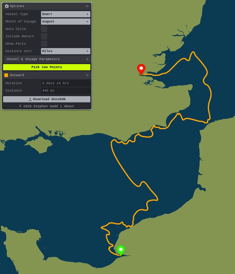
August 2, 2025 at 9:14 AM
Sounds amazing!
I'm curious to see how closely the cross-Channel route and timing match this 4-or-5-day wind-and-current-based prediction from docuracy.github.io/Historical_S...
I'm curious to see how closely the cross-Channel route and timing match this 4-or-5-day wind-and-current-based prediction from docuracy.github.io/Historical_S...
That's not what I see. Apply those unemployment rates to mid-career wages and it's evident that humanities are not a "safe financial bet". The situation is even worse when you factor in underemployment and investment in graduate degrees.

July 17, 2025 at 11:03 PM
That's not what I see. Apply those unemployment rates to mid-career wages and it's evident that humanities are not a "safe financial bet". The situation is even worse when you factor in underemployment and investment in graduate degrees.
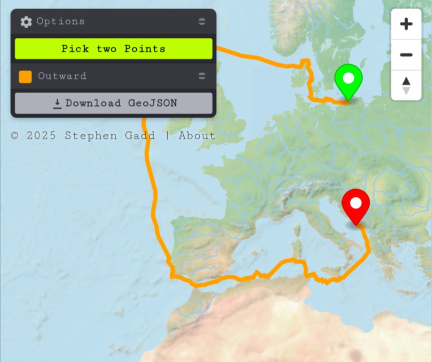
... docuracy.github.io/Historical_S... [4/3!]
Historical Sea Routing
Explore plausible historical sea routes and travel times.
docuracy.github.io
July 4, 2025 at 9:28 PM
... docuracy.github.io/Historical_S... [4/3!]
... 📖 All of the code for extending coverage can be found together with an outline of the methodology at github.com/docuracy/His.... [3/3]


July 4, 2025 at 9:07 PM
... 📖 All of the code for extending coverage can be found together with an outline of the methodology at github.com/docuracy/His.... [3/3]
... 📱It works better on mobile devices now too, using Mercator projection instead of globe, and with an initially-minimised Options panel. The routes and all parameters used can be exported for use in other GIS applications. [2/3]
July 4, 2025 at 9:07 PM
... 📱It works better on mobile devices now too, using Mercator projection instead of globe, and with an initially-minimised Options panel. The routes and all parameters used can be exported for use in other GIS applications. [2/3]
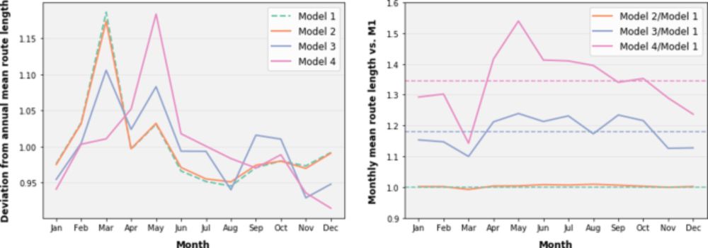
... Time of year makes a big difference too.
Monthly-weighted graphs are switched and new routes computed in less than half a second, all within the browser.
Monthly-weighted graphs are switched and new routes computed in less than half a second, all within the browser.
June 29, 2025 at 8:37 PM
... Time of year makes a big difference too.
Monthly-weighted graphs are switched and new routes computed in less than half a second, all within the browser.
Monthly-weighted graphs are switched and new routes computed in less than half a second, all within the browser.
... I need yet to tune the weighting of various parameters, but it’s striking how the same principles that shaped trans-Atlantic triangular trade routes in the age of sail apply on a more local scale too: prevailing winds, swell, waves, and currents all make return routes diverge from outbound ones.


June 29, 2025 at 7:23 PM
... I need yet to tune the weighting of various parameters, but it’s striking how the same principles that shaped trans-Atlantic triangular trade routes in the age of sail apply on a more local scale too: prevailing winds, swell, waves, and currents all make return routes diverge from outbound ones.
... Inspiration:
doi.org/10.1057/s415...
doi.org/10.1515/9783...
Data sources: @copernicusecmwf.bsky.social, @copernicusmarine.bsky.social
doi.org/10.1057/s415...
doi.org/10.1515/9783...
Data sources: @copernicusecmwf.bsky.social, @copernicusmarine.bsky.social
A multi-criteria simulation of European coastal shipping routes in the ‘age of sail’ - Humanities and Social Sciences Communications
Humanities and Social Sciences Communications - A multi-criteria simulation of European coastal shipping routes in the ‘age of sail’
doi.org
June 28, 2025 at 6:16 AM
... Inspiration:
doi.org/10.1057/s415...
doi.org/10.1515/9783...
Data sources: @copernicusecmwf.bsky.social, @copernicusmarine.bsky.social
doi.org/10.1057/s415...
doi.org/10.1515/9783...
Data sources: @copernicusecmwf.bsky.social, @copernicusmarine.bsky.social
... 🌊Each cell now has bathymetry and DEM-based clear-weather land-visibility data; also month-wise indicators of hourly-average wind, waves, surface current, and nocturnal+meteorological attenuation of visibility.
Thanks to @viabundus.bsky.social and @alexislitvine.bsky.social for inspiration!
Thanks to @viabundus.bsky.social and @alexislitvine.bsky.social for inspiration!

June 28, 2025 at 6:16 AM
... 🌊Each cell now has bathymetry and DEM-based clear-weather land-visibility data; also month-wise indicators of hourly-average wind, waves, surface current, and nocturnal+meteorological attenuation of visibility.
Thanks to @viabundus.bsky.social and @alexislitvine.bsky.social for inspiration!
Thanks to @viabundus.bsky.social and @alexislitvine.bsky.social for inspiration!
... using this graph of interconnected H3 (Hexagonal Hierarchical Geospatial Index) cells, I've computed and plotted a speculative historical sea route from Kilcolgan Castle to Faxfleet in under 2 seconds, all running in the browser. No server infrastructure or internet connection needed! ⛵

June 17, 2025 at 8:27 AM
... using this graph of interconnected H3 (Hexagonal Hierarchical Geospatial Index) cells, I've computed and plotted a speculative historical sea route from Kilcolgan Castle to Faxfleet in under 2 seconds, all running in the browser. No server infrastructure or internet connection needed! ⛵
My understanding is that in respect of markets and fairs such charters granted rights rather than obligations. Historical legal sources (e.g. Chitty, 1820) focus on forfeiture for misuse rather than non-use: there was not legal compulsion to operate what became unprofitable or impractical.
May 20, 2025 at 10:03 PM
My understanding is that in respect of markets and fairs such charters granted rights rather than obligations. Historical legal sources (e.g. Chitty, 1820) focus on forfeiture for misuse rather than non-use: there was not legal compulsion to operate what became unprofitable or impractical.