


Stephen Gadd
@docuracy.co.uk
Technical Director & Lead Software Developer, World Historical Gazetteer @whgazetteer.org
Research Associate, Unlocking Upcycled Medieval Data @ihr.bsky.social
GIS Consultant, Layers of London @layersoflondon.bsky.social
Research Associate, Unlocking Upcycled Medieval Data @ihr.bsky.social
GIS Consultant, Layers of London @layersoflondon.bsky.social
Sounds amazing!
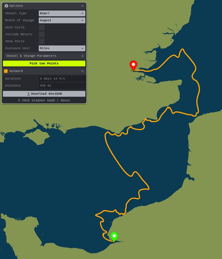
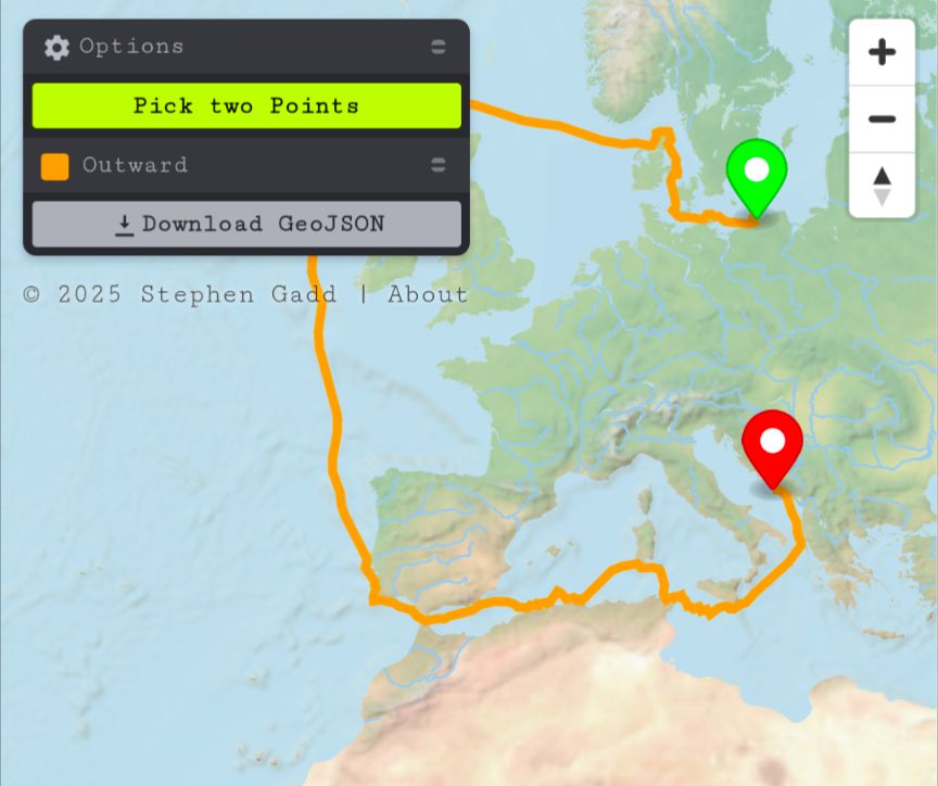
I'm curious to see how closely the cross-Channel route and timing match this 4-or-5-day wind-and-current-based prediction from docuracy.github.io/Historical_S...
I'm curious to see how closely the cross-Channel route and timing match this 4-or-5-day wind-and-current-based prediction from docuracy.github.io/Historical_S...
August 2, 2025 at 9:14 AM
Sounds amazing!
I'm curious to see how closely the cross-Channel route and timing match this 4-or-5-day wind-and-current-based prediction from docuracy.github.io/Historical_S...
I'm curious to see how closely the cross-Channel route and timing match this 4-or-5-day wind-and-current-based prediction from docuracy.github.io/Historical_S...
Hours of fun spent realigning my foolishly London-centric assumptions about medieval European trading networks. Shetland, for example, was far from peripheral: a non-Mercator map-projection helps.
I've rebuilt the journey-timed, square-rigged sailing algorithm for docuracy.github.io/Historical_S...
I've rebuilt the journey-timed, square-rigged sailing algorithm for docuracy.github.io/Historical_S...
July 19, 2025 at 7:01 AM
Hours of fun spent realigning my foolishly London-centric assumptions about medieval European trading networks. Shetland, for example, was far from peripheral: a non-Mercator map-projection helps.
I've rebuilt the journey-timed, square-rigged sailing algorithm for docuracy.github.io/Historical_S...
I've rebuilt the journey-timed, square-rigged sailing algorithm for docuracy.github.io/Historical_S...
That's not what I see. Apply those unemployment rates to mid-career wages and it's evident that humanities are not a "safe financial bet". The situation is even worse when you factor in underemployment and investment in graduate degrees.

July 17, 2025 at 11:03 PM
That's not what I see. Apply those unemployment rates to mid-career wages and it's evident that humanities are not a "safe financial bet". The situation is even worse when you factor in underemployment and investment in graduate degrees.
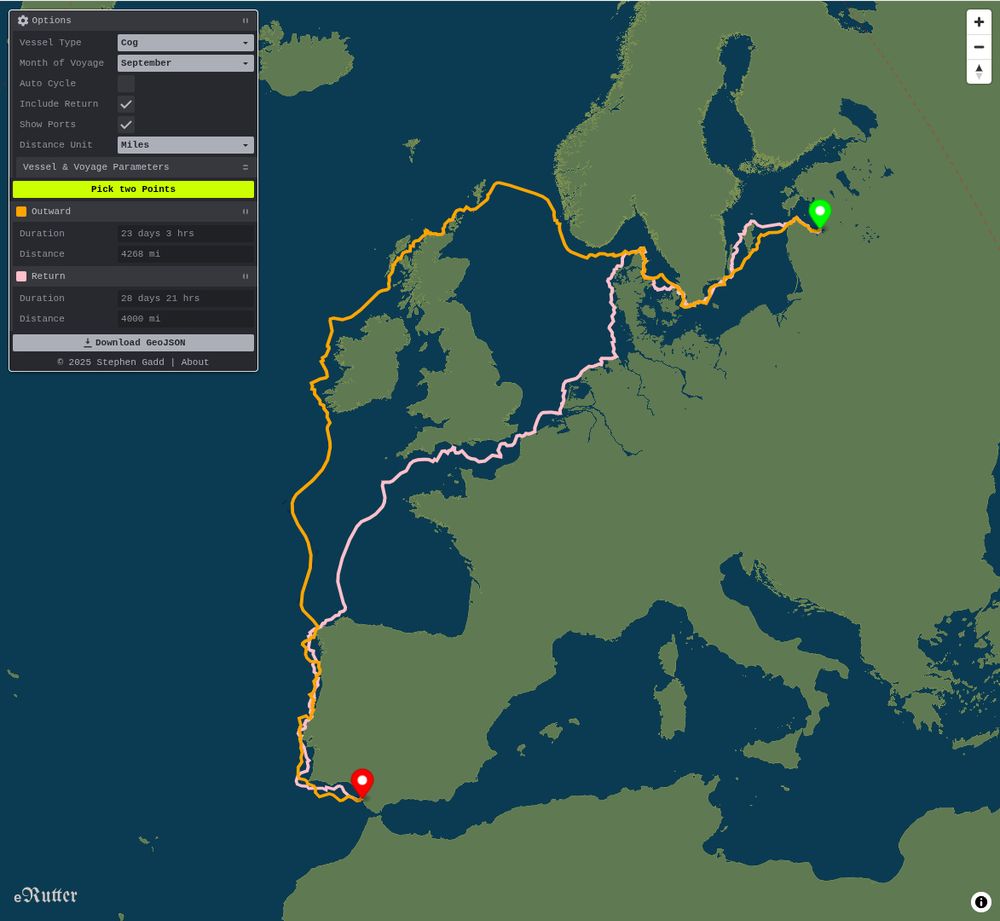
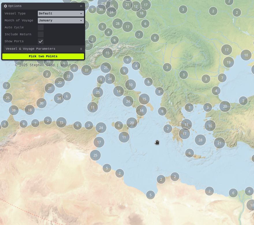
🌍 Ports are now (optionally) shown on the eRutter to help with route picking.
🤔 They're currently fetched from @wikidatacommunity.bsky.social, but this would be a great use case for a @whgazetteer.org temporal API to filter out modern ports and highlight ancient ones.
🤔 They're currently fetched from @wikidatacommunity.bsky.social, but this would be a great use case for a @whgazetteer.org temporal API to filter out modern ports and highlight ancient ones.

July 5, 2025 at 9:57 AM
🌍 Ports are now (optionally) shown on the eRutter to help with route picking.
🤔 They're currently fetched from @wikidatacommunity.bsky.social, but this would be a great use case for a @whgazetteer.org temporal API to filter out modern ports and highlight ancient ones.
🤔 They're currently fetched from @wikidatacommunity.bsky.social, but this would be a great use case for a @whgazetteer.org temporal API to filter out modern ports and highlight ancient ones.
... 📖 All of the code for extending coverage can be found together with an outline of the methodology at github.com/docuracy/His.... [3/3]


July 4, 2025 at 9:07 PM
... 📖 All of the code for extending coverage can be found together with an outline of the methodology at github.com/docuracy/His.... [3/3]
... 📱It works better on mobile devices now too, using Mercator projection instead of globe, and with an initially-minimised Options panel. The routes and all parameters used can be exported for use in other GIS applications. [2/3]
July 4, 2025 at 9:07 PM
... 📱It works better on mobile devices now too, using Mercator projection instead of globe, and with an initially-minimised Options panel. The routes and all parameters used can be exported for use in other GIS applications. [2/3]
🪄Historical Sea Routing is now much quicker to load, reload, and compute seasonally-plausible sailing routes, thanks to some behind-the-scenes browser magic. Find a 6500-mile return trip in under 1 second!
🛟 Do you have historical voyage data which might help with calibration? [1/3]
🛟 Do you have historical voyage data which might help with calibration? [1/3]
July 4, 2025 at 9:07 PM
🪄Historical Sea Routing is now much quicker to load, reload, and compute seasonally-plausible sailing routes, thanks to some behind-the-scenes browser magic. Find a 6500-mile return trip in under 1 second!
🛟 Do you have historical voyage data which might help with calibration? [1/3]
🛟 Do you have historical voyage data which might help with calibration? [1/3]
... Time of year makes a big difference too.
Monthly-weighted graphs are switched and new routes computed in less than half a second, all within the browser.
Monthly-weighted graphs are switched and new routes computed in less than half a second, all within the browser.
June 29, 2025 at 8:37 PM
... Time of year makes a big difference too.
Monthly-weighted graphs are switched and new routes computed in less than half a second, all within the browser.
Monthly-weighted graphs are switched and new routes computed in less than half a second, all within the browser.
... I need yet to tune the weighting of various parameters, but it’s striking how the same principles that shaped trans-Atlantic triangular trade routes in the age of sail apply on a more local scale too: prevailing winds, swell, waves, and currents all make return routes diverge from outbound ones.


June 29, 2025 at 7:23 PM
... I need yet to tune the weighting of various parameters, but it’s striking how the same principles that shaped trans-Atlantic triangular trade routes in the age of sail apply on a more local scale too: prevailing winds, swell, waves, and currents all make return routes diverge from outbound ones.
... 🌊Each cell now has bathymetry and DEM-based clear-weather land-visibility data; also month-wise indicators of hourly-average wind, waves, surface current, and nocturnal+meteorological attenuation of visibility.
Thanks to @viabundus.bsky.social and @alexislitvine.bsky.social for inspiration!
Thanks to @viabundus.bsky.social and @alexislitvine.bsky.social for inspiration!

June 28, 2025 at 6:16 AM
... 🌊Each cell now has bathymetry and DEM-based clear-weather land-visibility data; also month-wise indicators of hourly-average wind, waves, surface current, and nocturnal+meteorological attenuation of visibility.
Thanks to @viabundus.bsky.social and @alexislitvine.bsky.social for inspiration!
Thanks to @viabundus.bsky.social and @alexislitvine.bsky.social for inspiration!
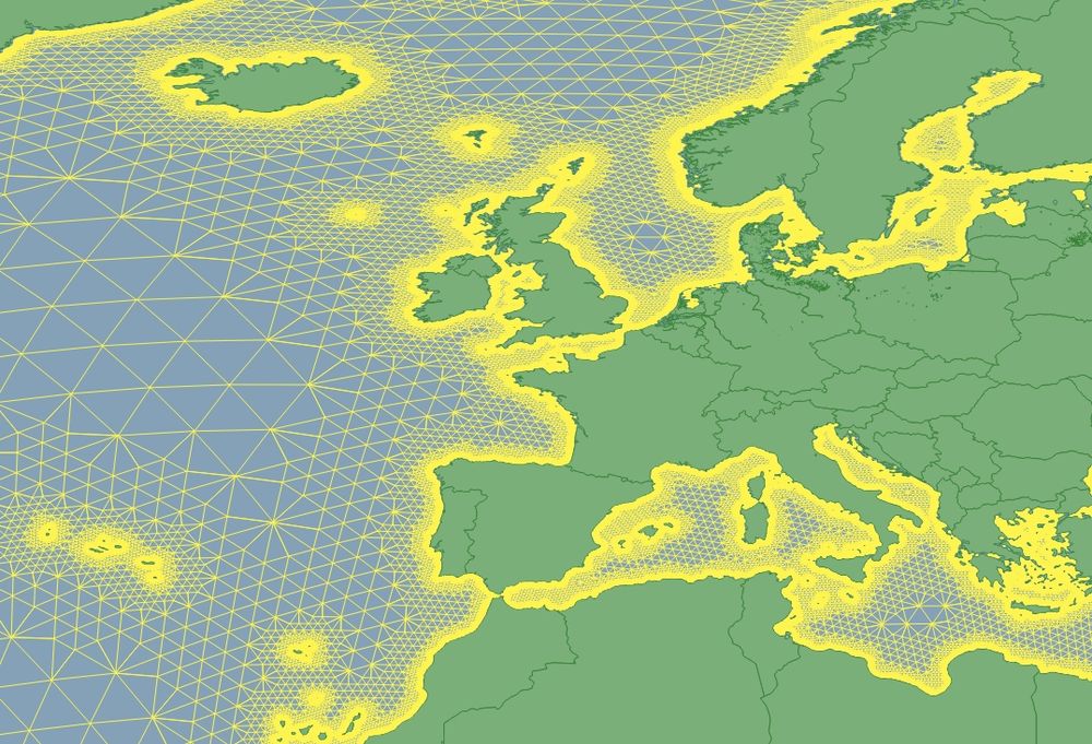
... using this graph of interconnected H3 (Hexagonal Hierarchical Geospatial Index) cells, I've computed and plotted a speculative historical sea route from Kilcolgan Castle to Faxfleet in under 2 seconds, all running in the browser. No server infrastructure or internet connection needed! ⛵

June 17, 2025 at 8:27 AM
... using this graph of interconnected H3 (Hexagonal Hierarchical Geospatial Index) cells, I've computed and plotted a speculative historical sea route from Kilcolgan Castle to Faxfleet in under 2 seconds, all running in the browser. No server infrastructure or internet connection needed! ⛵
🧭 Building a lightweight sea-routing graph for historical GIS & DH use cases beyond simple port-to-port hops. Edges are weighted for ~5km coastal preference. Aiming for serverless exploration of connectivity in historical maritime trade. ⚓️ #MaritimeHistory #HistoricalGIS #DigitalHumanities

June 16, 2025 at 7:26 PM
🧭 Building a lightweight sea-routing graph for historical GIS & DH use cases beyond simple port-to-port hops. Edges are weighted for ~5km coastal preference. Aiming for serverless exploration of connectivity in historical maritime trade. ⚓️ #MaritimeHistory #HistoricalGIS #DigitalHumanities
... although it picks out the Great Eastern lines very clearly.

April 30, 2025 at 6:44 PM
... although it picks out the Great Eastern lines very clearly.
👇Results from my latest version of desCartes, a hybrid machine learning system for detecting roads on old maps. Its 0.76 IoU score for roads is 31% better than the closest benchmark. 🤯
Preprint forthcoming on arXiv.
Preprint forthcoming on arXiv.


March 30, 2025 at 8:32 PM
👇Results from my latest version of desCartes, a hybrid machine learning system for detecting roads on old maps. Its 0.76 IoU score for roads is 31% better than the closest benchmark. 🤯
Preprint forthcoming on arXiv.
Preprint forthcoming on arXiv.
Here it is on @layersoflondon.bsky.social in 1746, where you can also find an overlay of Strype's maps for 1694-1720. The area isn't labelled on those, though.
www.layersoflondon.org/map/overlays...
www.layersoflondon.org/map/overlays...
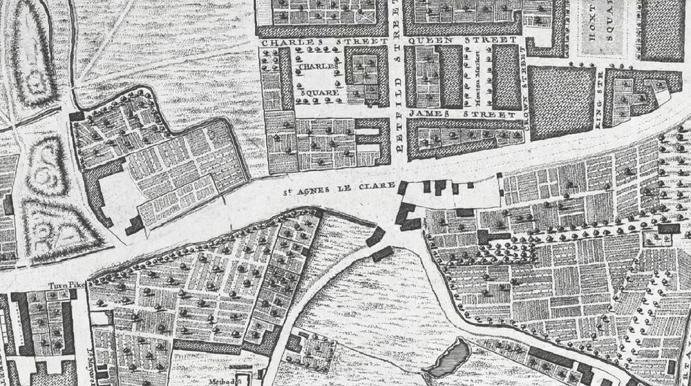

March 28, 2025 at 11:48 PM
Here it is on @layersoflondon.bsky.social in 1746, where you can also find an overlay of Strype's maps for 1694-1720. The area isn't labelled on those, though.
www.layersoflondon.org/map/overlays...
www.layersoflondon.org/map/overlays...
Inventor Alexander Lagerman's beautiful machines in the Matchstick Museum (Tändstickmuseet), Jönköping, including a fairly early (1892) industrial example of non-circular gears. 👌🏻
sv.m.wikipedia.org/wiki/Alexand...
sv.m.wikipedia.org/wiki/Alexand...


January 4, 2025 at 2:42 PM
Inventor Alexander Lagerman's beautiful machines in the Matchstick Museum (Tändstickmuseet), Jönköping, including a fairly early (1892) industrial example of non-circular gears. 👌🏻
sv.m.wikipedia.org/wiki/Alexand...
sv.m.wikipedia.org/wiki/Alexand...
Very nice, but there was an earlier pier as shown here in 1872 [https://www.jp137.com/day/6294.jpg]. Bournemouth Local History page on Facebook is a great resource with photos and possibly some of Birch's plans [https://www.facebook.com/profile/100069362520922/search/?q=pier].

December 21, 2024 at 7:30 PM
Very nice, but there was an earlier pier as shown here in 1872 [https://www.jp137.com/day/6294.jpg]. Bournemouth Local History page on Facebook is a great resource with photos and possibly some of Birch's plans [https://www.facebook.com/profile/100069362520922/search/?q=pier].
... well, this is a fascinating catalogue of (among other things) watermarks: www.memoryofpaper.eu/BernsteinPor...
It led me to what looks like a very close match dated 1752 here: www.academiacolecciones.com/dibujos/inve...
It led me to what looks like a very close match dated 1752 here: www.academiacolecciones.com/dibujos/inve...

February 22, 2024 at 10:14 PM
... well, this is a fascinating catalogue of (among other things) watermarks: www.memoryofpaper.eu/BernsteinPor...
It led me to what looks like a very close match dated 1752 here: www.academiacolecciones.com/dibujos/inve...
It led me to what looks like a very close match dated 1752 here: www.academiacolecciones.com/dibujos/inve...
Help, please? I'm trying to date a ledger by its watermarks and ruled lines (see attached). Does anyone here know how the Villedary marks changed over their long period of production?


February 21, 2024 at 4:50 PM
Help, please? I'm trying to date a ledger by its watermarks and ruled lines (see attached). Does anyone here know how the Villedary marks changed over their long period of production?
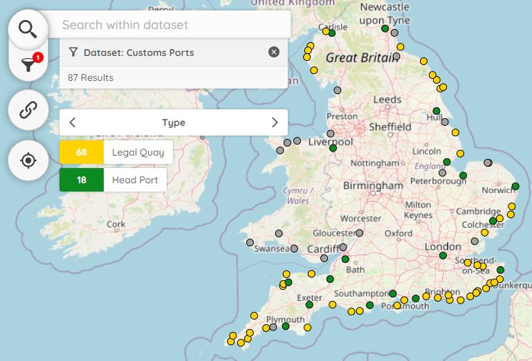
... the map can now show which ports had a Legal Quay.
My 2017 article explores how the lack of a Legal Quay (for import and export of goods) tended to suppress coastal trade too: ehs.org.uk/article/ille...
docuracy.github.io/Elizabethan_...
My 2017 article explores how the lack of a Legal Quay (for import and export of goods) tended to suppress coastal trade too: ehs.org.uk/article/ille...
docuracy.github.io/Elizabethan_...
February 12, 2024 at 5:58 PM
... the map can now show which ports had a Legal Quay.
My 2017 article explores how the lack of a Legal Quay (for import and export of goods) tended to suppress coastal trade too: ehs.org.uk/article/ille...
docuracy.github.io/Elizabethan_...
My 2017 article explores how the lack of a Legal Quay (for import and export of goods) tended to suppress coastal trade too: ehs.org.uk/article/ille...
docuracy.github.io/Elizabethan_...
...fixed the map links so that you can now read the corresponding transcripts without having to download the entire dataset.


February 12, 2024 at 10:29 AM
...fixed the map links so that you can now read the corresponding transcripts without having to download the entire dataset.
I've finally got round to publishing the geolocated transcripts I made of several Elizabethan Coastal Surveys (1565). Primarily for "suppressing pirates and other disorders" and for Customs regulation, they include details of local populations and vessels.
github.com/docuracy/Eli...
github.com/docuracy/Eli...
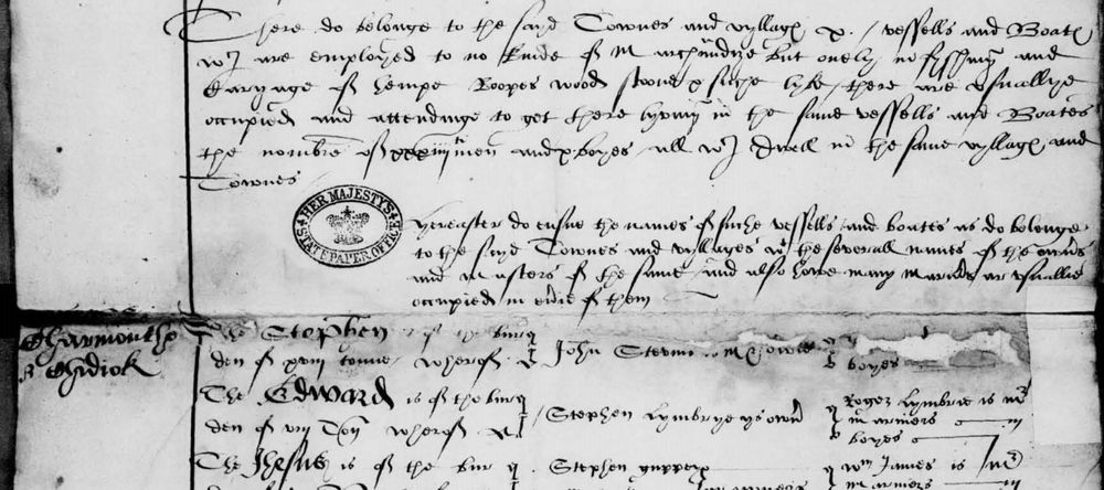

February 12, 2024 at 8:56 AM
I've finally got round to publishing the geolocated transcripts I made of several Elizabethan Coastal Surveys (1565). Primarily for "suppressing pirates and other disorders" and for Customs regulation, they include details of local populations and vessels.
github.com/docuracy/Eli...
github.com/docuracy/Eli...

January 20, 2024 at 11:53 AM