


CycloneCyrus
@cyrusaviatricon.bsky.social
Writing, informing, evaluating about tropical cyclones all over the world.
I write on Medium: https://medium.com/@cyrusaviatricon_edasn
I write on Medium: https://medium.com/@cyrusaviatricon_edasn
#WeatherStory, No.3:
Below is the TIROS satellite picture of Typhoon #Gloria in the Western Pacific basin in 1961, alongside a track of the system. Only limited information is available about Gloria's TIROS satellite image, but it was captured likely at or near its peak intensity.
#tropics
Below is the TIROS satellite picture of Typhoon #Gloria in the Western Pacific basin in 1961, alongside a track of the system. Only limited information is available about Gloria's TIROS satellite image, but it was captured likely at or near its peak intensity.
#tropics


August 4, 2025 at 2:15 PM
#WeatherStory, No.3:
Below is the TIROS satellite picture of Typhoon #Gloria in the Western Pacific basin in 1961, alongside a track of the system. Only limited information is available about Gloria's TIROS satellite image, but it was captured likely at or near its peak intensity.
#tropics
Below is the TIROS satellite picture of Typhoon #Gloria in the Western Pacific basin in 1961, alongside a track of the system. Only limited information is available about Gloria's TIROS satellite image, but it was captured likely at or near its peak intensity.
#tropics
#WeatherStory, No. 2
Below is the TIROS-3 satellite image of the unnamed September 12-15, 1961 tropical storm that impacted the East Coast of the United States on September 12 near the #Bahamas, as a tropical depression.
No deaths tallied, but strong winds downed trees and power lines.
#tropics
Below is the TIROS-3 satellite image of the unnamed September 12-15, 1961 tropical storm that impacted the East Coast of the United States on September 12 near the #Bahamas, as a tropical depression.
No deaths tallied, but strong winds downed trees and power lines.
#tropics

August 4, 2025 at 1:30 PM
#WeatherStory, No. 2
Below is the TIROS-3 satellite image of the unnamed September 12-15, 1961 tropical storm that impacted the East Coast of the United States on September 12 near the #Bahamas, as a tropical depression.
No deaths tallied, but strong winds downed trees and power lines.
#tropics
Below is the TIROS-3 satellite image of the unnamed September 12-15, 1961 tropical storm that impacted the East Coast of the United States on September 12 near the #Bahamas, as a tropical depression.
No deaths tallied, but strong winds downed trees and power lines.
#tropics
The last tropical cyclone to be named in the Central Pacific is in 2024, when Tropical Depression #One-C was named as Tropical Storm #Hone on August 26. It later strengthened to a hurricane and brushed #Hawaii.
After that is back to 2019, with Tropical Storm #Ema on October 12.
2/2
#tropics
After that is back to 2019, with Tropical Storm #Ema on October 12.
2/2
#tropics


July 27, 2025 at 1:37 PM
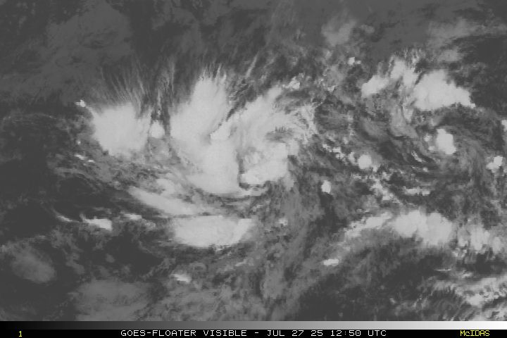
And... the streak for a tropical cyclone being named in the Central Pacific basin will continue this year!
Tropical Depression #One-C formed at 09:00 UTC on July 27, far southeast of #Hawaii. Current forecasts call for the system to intensify steadily to Tropical Storm #Iona today!
1/2
#tropics
Tropical Depression #One-C formed at 09:00 UTC on July 27, far southeast of #Hawaii. Current forecasts call for the system to intensify steadily to Tropical Storm #Iona today!
1/2
#tropics

July 27, 2025 at 1:37 PM
The current view of the Western Pacific basin, as of 05:30 UTC on July 24, 2025.
Three active tropical cyclones can be seen below:
- STS #Co-may ( #EmongPH ) near the #Philippines.
- TS #Francisco ( #DantePH ) near the #RyukyuIslands.
- TS #Krosa near the #NorthernMarianaIslands.
#tropics
Three active tropical cyclones can be seen below:
- STS #Co-may ( #EmongPH ) near the #Philippines.
- TS #Francisco ( #DantePH ) near the #RyukyuIslands.
- TS #Krosa near the #NorthernMarianaIslands.
#tropics

July 24, 2025 at 5:43 AM
The current view of the Western Pacific basin, as of 05:30 UTC on July 24, 2025.
Three active tropical cyclones can be seen below:
- STS #Co-may ( #EmongPH ) near the #Philippines.
- TS #Francisco ( #DantePH ) near the #RyukyuIslands.
- TS #Krosa near the #NorthernMarianaIslands.
#tropics
Three active tropical cyclones can be seen below:
- STS #Co-may ( #EmongPH ) near the #Philippines.
- TS #Francisco ( #DantePH ) near the #RyukyuIslands.
- TS #Krosa near the #NorthernMarianaIslands.
#tropics
#Co-may ( #EmongPH ) is currently intensifying at a quick pace while nearing the #Philippines. Storm Signals 1-3 now in place over a wide swath of #Luzon Island.
As of 03:00 UTC on July 24, the JTWC and PAGASA consider Co-may at #typhoon strength, while the JMA keeps it at STS strength.
#tropics
As of 03:00 UTC on July 24, the JTWC and PAGASA consider Co-may at #typhoon strength, while the JMA keeps it at STS strength.
#tropics


July 24, 2025 at 5:35 AM
#WeatherStory, No. 1
Below is the Cape Muroto, #Kōchi Prefecture radar image of Typhoon #Della as it approached the Japanese archipelago ahead of its landfall on August 29, 1960.
What appears to be the eye of Della can be seen on the photo. The storm killed at least 55 in the country.
#tropics
Below is the Cape Muroto, #Kōchi Prefecture radar image of Typhoon #Della as it approached the Japanese archipelago ahead of its landfall on August 29, 1960.
What appears to be the eye of Della can be seen on the photo. The storm killed at least 55 in the country.
#tropics

July 23, 2025 at 3:38 PM
#WeatherStory, No. 1
Below is the Cape Muroto, #Kōchi Prefecture radar image of Typhoon #Della as it approached the Japanese archipelago ahead of its landfall on August 29, 1960.
What appears to be the eye of Della can be seen on the photo. The storm killed at least 55 in the country.
#tropics
Below is the Cape Muroto, #Kōchi Prefecture radar image of Typhoon #Della as it approached the Japanese archipelago ahead of its landfall on August 29, 1960.
What appears to be the eye of Della can be seen on the photo. The storm killed at least 55 in the country.
#tropics
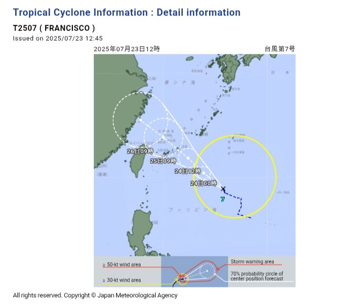
#DantePH has strengthened to a tropical storm inside PAR, now bearing the name #Francisco (right). The LPA near the #Ilocos Region has also intensified to a tropical depression, with the PAGASA naming it #EmongPH (left).
Both are influencing the southwest monsoon in the Philippines.
#tropics
Both are influencing the southwest monsoon in the Philippines.
#tropics


July 23, 2025 at 5:23 AM
#DantePH has strengthened to a tropical storm inside PAR, now bearing the name #Francisco (right). The LPA near the #Ilocos Region has also intensified to a tropical depression, with the PAGASA naming it #EmongPH (left).
Both are influencing the southwest monsoon in the Philippines.
#tropics
Both are influencing the southwest monsoon in the Philippines.
#tropics
The PAGASA debuts their new layout (left) of their Track and Intensity Forecast bulletin, starting with Tropical Depression #DantePH.
The previous layout of the bulletin, last used for Severe Tropical Storm #CrisingPH (international name: #Wipha) is in the right.
The previous layout of the bulletin, last used for Severe Tropical Storm #CrisingPH (international name: #Wipha) is in the right.


July 22, 2025 at 12:23 PM
The PAGASA debuts their new layout (left) of their Track and Intensity Forecast bulletin, starting with Tropical Depression #DantePH.
The previous layout of the bulletin, last used for Severe Tropical Storm #CrisingPH (international name: #Wipha) is in the right.
The previous layout of the bulletin, last used for Severe Tropical Storm #CrisingPH (international name: #Wipha) is in the right.