


CYMS Cyclone Monitoring Service by Sentinel-1
@cyms-s1.bsky.social
CYMS provides SAR-derived ocean surface wind speed data derived along Tropical Cyclone tracks, with NRT and reprocessed data, now funded by MPC-S1.
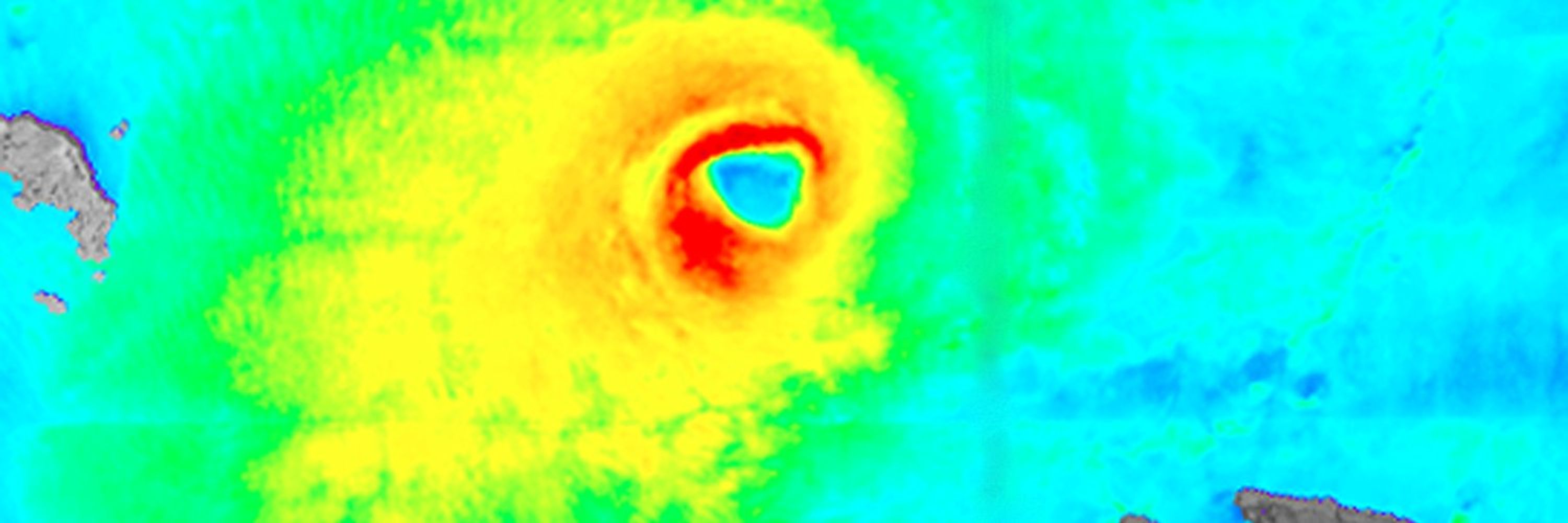
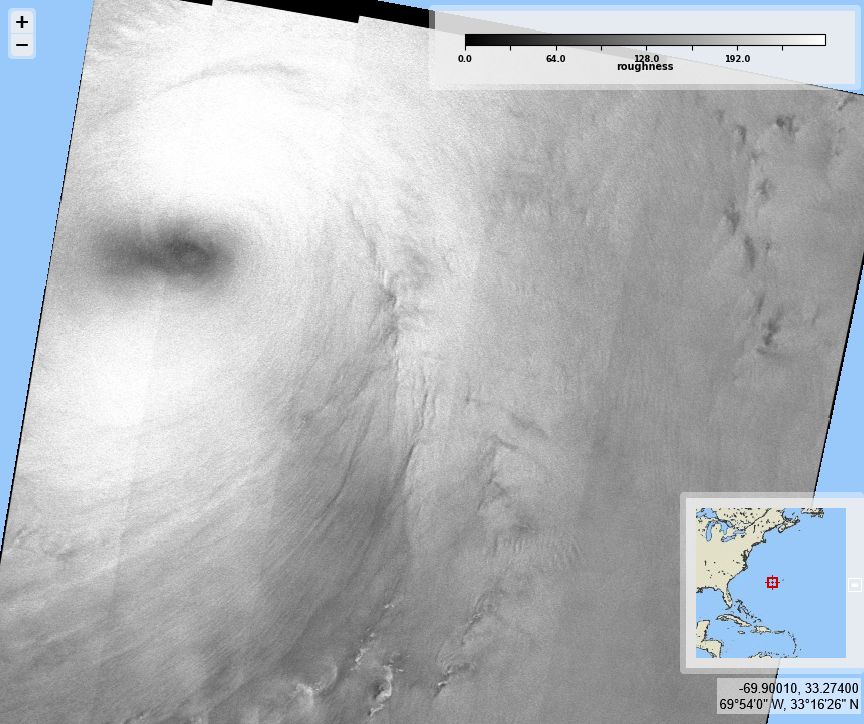
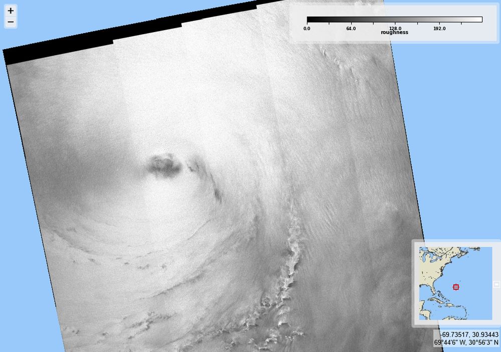
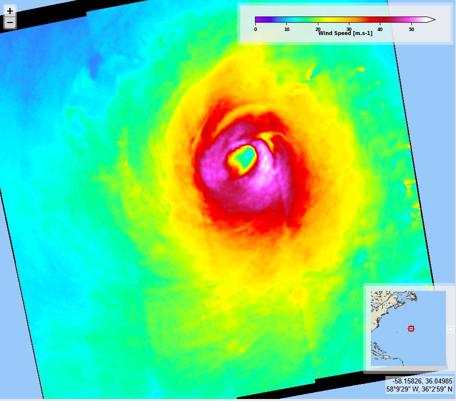
Tropical storm / Typhoon #Koto @esaearth.esa.int acquisitions on 2025/11/25 & 26, 21:54 & 10:21 for #2025SHOC from Copernicus @sentinelonline #Sentinel1 C. Max sustained wind velocities nearing 35 m/s (left), derived from SAR sea surface roughness (right).


November 27, 2025 at 7:50 AM
Tropical storm / Typhoon #Koto @esaearth.esa.int acquisitions on 2025/11/25 & 26, 21:54 & 10:21 for #2025SHOC from Copernicus @sentinelonline #Sentinel1 C. Max sustained wind velocities nearing 35 m/s (left), derived from SAR sea surface roughness (right).
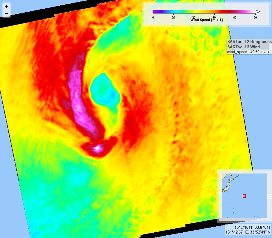
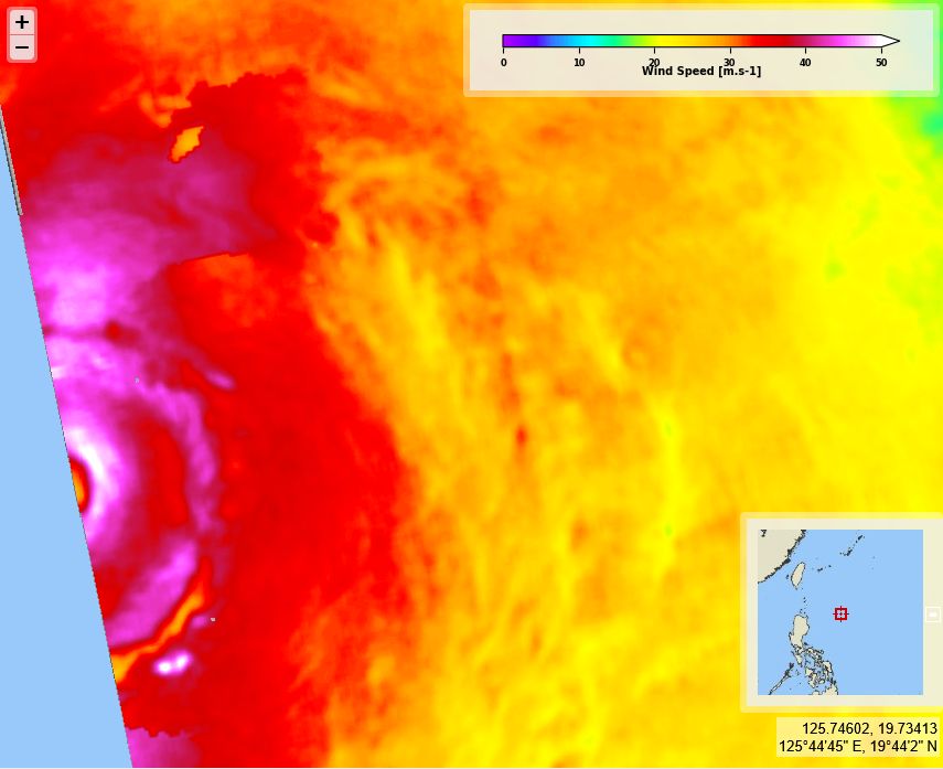
Typhoon #Fung-wong, before and after hitting Philippines. @esaearth.esa.int acquisitions on 2025/11/07, 08 and 10 for #2025SHOC from Copernicus @sentinelonline #Sentinel1 A & C. Max sustained wind velocities nearing 45 m/s on Nov. 8


November 12, 2025 at 8:31 AM
Typhoon #Fung-wong, before and after hitting Philippines. @esaearth.esa.int acquisitions on 2025/11/07, 08 and 10 for #2025SHOC from Copernicus @sentinelonline #Sentinel1 A & C. Max sustained wind velocities nearing 45 m/s on Nov. 8
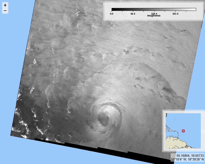
Hurricane #Melissa south of Jamaica. @esaearth.esa.int acquisitions on 2025/10/27 11:04 UTC for #2025SHOC from Copernicus @sentinelonline.bsky.social #Sentinel1 A. Max sustained wind velocities nearing 70 m/s (left), derived from SAR sea surface roughness (right).


October 28, 2025 at 7:24 AM
Hurricane #Melissa south of Jamaica. @esaearth.esa.int acquisitions on 2025/10/27 11:04 UTC for #2025SHOC from Copernicus @sentinelonline.bsky.social #Sentinel1 A. Max sustained wind velocities nearing 70 m/s (left), derived from SAR sea surface roughness (right).
Cyclone #Chenge (still a storm), in the Indian Ocean and Typhoon #Fengshen South of Hainan Island. @esaearth.esa.int acquisitions on 2025/10/21 1:18 & 22:34 UTC for #2025SHOC from Copernicus @sentinelonline.bsky.social #Sentinel1 C. Max sustained winds (left), derived from SAR roughness (right).


October 23, 2025 at 7:11 AM
Cyclone #Chenge (still a storm), in the Indian Ocean and Typhoon #Fengshen South of Hainan Island. @esaearth.esa.int acquisitions on 2025/10/21 1:18 & 22:34 UTC for #2025SHOC from Copernicus @sentinelonline.bsky.social #Sentinel1 C. Max sustained winds (left), derived from SAR roughness (right).
Typhoon #Nakri. @esaearth.esa.int acquisitions on 2025/10/11 9:21 UTC for #2025SHOC from Copernicus #Sentinel1 A. Max sustained wind velocities nearing 35 m/s (left), derived from SAR sea surface roughness (right).


October 13, 2025 at 7:01 AM
Typhoon #Nakri. @esaearth.esa.int acquisitions on 2025/10/11 9:21 UTC for #2025SHOC from Copernicus #Sentinel1 A. Max sustained wind velocities nearing 35 m/s (left), derived from SAR sea surface roughness (right).
Typhoon #Halong south of Japan. @esaearth.esa.int acquisitions on 2025/10/08 8:57 UTC for #2025SHOC from Copernicus @sentinelonline.bsky.social #Sentinel1 A. Max sustained wind velocities over 45 m/s (left), derived from SAR sea surface roughness (right).


October 9, 2025 at 7:30 AM
Typhoon #Halong south of Japan. @esaearth.esa.int acquisitions on 2025/10/08 8:57 UTC for #2025SHOC from Copernicus @sentinelonline.bsky.social #Sentinel1 A. Max sustained wind velocities over 45 m/s (left), derived from SAR sea surface roughness (right).
Hurricane #Priscilla south of Baja California . @esaearth.esa.int
acquisitions on 2025/10/08, 1:03 for #2025SHOC from Copernicus @sentinelonline.bsky.social #Sentinel1 C Max sustained wind velocities just below 40 m/s (left), derived from SAR sea surface roughness (right).
acquisitions on 2025/10/08, 1:03 for #2025SHOC from Copernicus @sentinelonline.bsky.social #Sentinel1 C Max sustained wind velocities just below 40 m/s (left), derived from SAR sea surface roughness (right).


October 8, 2025 at 6:48 AM
Hurricane #Priscilla south of Baja California . @esaearth.esa.int
acquisitions on 2025/10/08, 1:03 for #2025SHOC from Copernicus @sentinelonline.bsky.social #Sentinel1 C Max sustained wind velocities just below 40 m/s (left), derived from SAR sea surface roughness (right).
acquisitions on 2025/10/08, 1:03 for #2025SHOC from Copernicus @sentinelonline.bsky.social #Sentinel1 C Max sustained wind velocities just below 40 m/s (left), derived from SAR sea surface roughness (right).
Typhoon #Matmo landing close to Hainan island.
@esaearth.esa.int acquisitions on 2025/10/04 22:25 UTC for #2025SHOC from Copernicus @sentinelonline.bsky.social #Sentinel1 C. Max sustained wind velocities over 45 m/s (left), derived from SAR sea surface roughness (right).
@esaearth.esa.int acquisitions on 2025/10/04 22:25 UTC for #2025SHOC from Copernicus @sentinelonline.bsky.social #Sentinel1 C. Max sustained wind velocities over 45 m/s (left), derived from SAR sea surface roughness (right).


October 6, 2025 at 6:50 AM
Typhoon #Matmo landing close to Hainan island.
@esaearth.esa.int acquisitions on 2025/10/04 22:25 UTC for #2025SHOC from Copernicus @sentinelonline.bsky.social #Sentinel1 C. Max sustained wind velocities over 45 m/s (left), derived from SAR sea surface roughness (right).
@esaearth.esa.int acquisitions on 2025/10/04 22:25 UTC for #2025SHOC from Copernicus @sentinelonline.bsky.social #Sentinel1 C. Max sustained wind velocities over 45 m/s (left), derived from SAR sea surface roughness (right).
Hurricane #Imelda decreasing in intensity while going north in the Atlantic. @esaearth.esa.int acquisitions on 2025/10/03 & 04 for #2025SHOC from Copernicus @sentinelonline.bsky.social
#Sentinel1 C & A. Max sustained wind velocities from about 37 to 26 m/s, derived from SAR sea surface roughness.
#Sentinel1 C & A. Max sustained wind velocities from about 37 to 26 m/s, derived from SAR sea surface roughness.


October 6, 2025 at 6:44 AM
Hurricane #Imelda decreasing in intensity while going north in the Atlantic. @esaearth.esa.int acquisitions on 2025/10/03 & 04 for #2025SHOC from Copernicus @sentinelonline.bsky.social
#Sentinel1 C & A. Max sustained wind velocities from about 37 to 26 m/s, derived from SAR sea surface roughness.
#Sentinel1 C & A. Max sustained wind velocities from about 37 to 26 m/s, derived from SAR sea surface roughness.
Hurricane #Imelda, again in North Atlantic.
@esaearth.esa.int acquisitions on 2025/10/01 10:25 UTC for #2025SHOC from Copernicus
@sentinelonline.bsky.social #Sentinel1 C. Max sustained wind velocities just under 40 m/s (left), derived from SAR sea surface roughness (right).
@esaearth.esa.int acquisitions on 2025/10/01 10:25 UTC for #2025SHOC from Copernicus
@sentinelonline.bsky.social #Sentinel1 C. Max sustained wind velocities just under 40 m/s (left), derived from SAR sea surface roughness (right).


October 2, 2025 at 6:30 AM
Hurricane #Imelda, again in North Atlantic.
@esaearth.esa.int acquisitions on 2025/10/01 10:25 UTC for #2025SHOC from Copernicus
@sentinelonline.bsky.social #Sentinel1 C. Max sustained wind velocities just under 40 m/s (left), derived from SAR sea surface roughness (right).
@esaearth.esa.int acquisitions on 2025/10/01 10:25 UTC for #2025SHOC from Copernicus
@sentinelonline.bsky.social #Sentinel1 C. Max sustained wind velocities just under 40 m/s (left), derived from SAR sea surface roughness (right).
Hurricane #Humberto in North Atlantic again. @esaearth.esa.int.bsky.social
acquisitions on 2025/09/30 10:35 UTC for #2025SHOC from Copernicus @sentinelonline.bsky.social
#Sentinel1 A. Max sustained wind velocities just over 40 m/s (left), derived from SAR sea surface roughness (right).
acquisitions on 2025/09/30 10:35 UTC for #2025SHOC from Copernicus @sentinelonline.bsky.social
#Sentinel1 A. Max sustained wind velocities just over 40 m/s (left), derived from SAR sea surface roughness (right).

October 1, 2025 at 6:57 AM
Hurricane #Humberto in North Atlantic again. @esaearth.esa.int.bsky.social
acquisitions on 2025/09/30 10:35 UTC for #2025SHOC from Copernicus @sentinelonline.bsky.social
#Sentinel1 A. Max sustained wind velocities just over 40 m/s (left), derived from SAR sea surface roughness (right).
acquisitions on 2025/09/30 10:35 UTC for #2025SHOC from Copernicus @sentinelonline.bsky.social
#Sentinel1 A. Max sustained wind velocities just over 40 m/s (left), derived from SAR sea surface roughness (right).
Hurricane #Humberto continuing its way around North Atlantic. @esaearth.esa.int.bsky.social
acquisitions on 2025/09/29 22:31 UTC for #2025SHOC from Copernicus @sentinelonline.bsky.social
#Sentinel1 A. Max sustained wind velocities over 60 m/s (left), derived from SAR sea surface roughness (right).
acquisitions on 2025/09/29 22:31 UTC for #2025SHOC from Copernicus @sentinelonline.bsky.social
#Sentinel1 A. Max sustained wind velocities over 60 m/s (left), derived from SAR sea surface roughness (right).

September 30, 2025 at 6:32 AM
Hurricane #Humberto continuing its way around North Atlantic. @esaearth.esa.int.bsky.social
acquisitions on 2025/09/29 22:31 UTC for #2025SHOC from Copernicus @sentinelonline.bsky.social
#Sentinel1 A. Max sustained wind velocities over 60 m/s (left), derived from SAR sea surface roughness (right).
acquisitions on 2025/09/29 22:31 UTC for #2025SHOC from Copernicus @sentinelonline.bsky.social
#Sentinel1 A. Max sustained wind velocities over 60 m/s (left), derived from SAR sea surface roughness (right).
Hurricanes and remnants in the North Atlantic, on 2025/09 26, 27 & 28: #Gabrielle remnants, #Humberto and #Imelda. #2025SHOC from Copernicus @sentinelonline #Sentinel1 A & C. Max sustained wind velocities from around 35 m/s to 55 m/s, derived from SAR sea surface roughness.


September 29, 2025 at 7:42 AM
Hurricanes and remnants in the North Atlantic, on 2025/09 26, 27 & 28: #Gabrielle remnants, #Humberto and #Imelda. #2025SHOC from Copernicus @sentinelonline #Sentinel1 A & C. Max sustained wind velocities from around 35 m/s to 55 m/s, derived from SAR sea surface roughness.
Typhoon #Neoguri and Hurricane #Narda on both sides of the Pacific on 2025/09/27 & 28, 14:20 & 7:03 UTC. #2025SHOC from Copernicus @sentinelonline #Sentinel1 A & C. Max sustained wind velocities 35 m/s and over 61 m/s resp., derived from SAR sea surface roughness.


September 29, 2025 at 7:36 AM
Typhoon #Neoguri and Hurricane #Narda on both sides of the Pacific on 2025/09/27 & 28, 14:20 & 7:03 UTC. #2025SHOC from Copernicus @sentinelonline #Sentinel1 A & C. Max sustained wind velocities 35 m/s and over 61 m/s resp., derived from SAR sea surface roughness.
Typhoon #Ragasa on 2025/09/23 22:17 UTC touching the coasts of China. #2025SHOC from Copernicus @sentinelonline.bsky.social
#Sentinel1 A. Max sustained wind velocities (left) around 52 m/s, derived from SAR sea surface roughness (right).
#Sentinel1 A. Max sustained wind velocities (left) around 52 m/s, derived from SAR sea surface roughness (right).


September 24, 2025 at 5:30 PM
Typhoon #Ragasa on 2025/09/23 22:17 UTC touching the coasts of China. #2025SHOC from Copernicus @sentinelonline.bsky.social
#Sentinel1 A. Max sustained wind velocities (left) around 52 m/s, derived from SAR sea surface roughness (right).
#Sentinel1 A. Max sustained wind velocities (left) around 52 m/s, derived from SAR sea surface roughness (right).
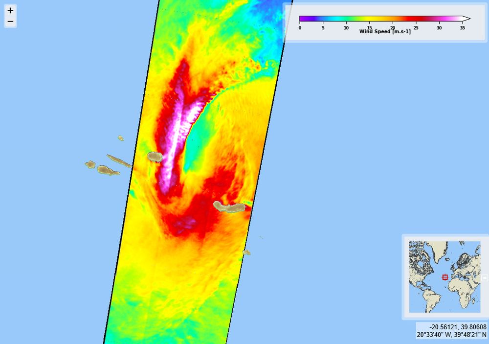
Hurricane #Gabrielle, North Atlantic. @esaearth.esa.int acquisitions on 2025/09/23 9:52 & 21:43 UTC), for #2025SHOC from Copernicus @sentinelonline #Sentinel1 A. Max sustained wind velocities (left) over 50 m/s and 53 m/s, derived from SAR sea surface roughness.


September 24, 2025 at 5:23 PM
Hurricane #Gabrielle, North Atlantic. @esaearth.esa.int acquisitions on 2025/09/23 9:52 & 21:43 UTC), for #2025SHOC from Copernicus @sentinelonline #Sentinel1 A. Max sustained wind velocities (left) over 50 m/s and 53 m/s, derived from SAR sea surface roughness.
Typhoons #Ragasa & #Neoguri again, on 2025/09/19, 23 & 24, for #2025SHOC from Copernicus @sentinelonline #Sentinel1 A & C. Max sustained wind velocities ranging from around 35 to 52 m/s, derived from SAR sea surface roughness.


September 24, 2025 at 5:15 PM
Typhoons #Ragasa & #Neoguri again, on 2025/09/19, 23 & 24, for #2025SHOC from Copernicus @sentinelonline #Sentinel1 A & C. Max sustained wind velocities ranging from around 35 to 52 m/s, derived from SAR sea surface roughness.
Typhoons Ragasa and Neoguri, on 2025/09/21, for #2025SHOC from Copernicus @sentinelonline #Sentinel1 C. Max sustained wind velocities, derived from SAR sea surface roughness using extreme-wind dedicated processing.


September 22, 2025 at 6:06 AM
Typhoons Ragasa and Neoguri, on 2025/09/21, for #2025SHOC from Copernicus @sentinelonline #Sentinel1 C. Max sustained wind velocities, derived from SAR sea surface roughness using extreme-wind dedicated processing.
Hurricane #Kiko, going west to central Pacific. @esaearth.esa.int acquisitions on 2025/09/06 , 07 & 08 (3:23, 15:26 & 3:56 UTC), for #2025SHOC from Copernicus @sentinelonline #Sentinel1 A (09/06) & C (07 & 08). Max wind over 55 m/s (09/06) & 45 m/s (07 & 08), derived from SAR sea surface roughness.


September 9, 2025 at 6:57 AM
Hurricane #Kiko, going west to central Pacific. @esaearth.esa.int acquisitions on 2025/09/06 , 07 & 08 (3:23, 15:26 & 3:56 UTC), for #2025SHOC from Copernicus @sentinelonline #Sentinel1 A (09/06) & C (07 & 08). Max wind over 55 m/s (09/06) & 45 m/s (07 & 08), derived from SAR sea surface roughness.
Hurricane #Kiko, central Pacific. @esaearth.esa.int acquisitions on 2025/09/02 14:30 UTC, for #2025SHOC from Copernicus #Sentinel1 A. Max sustained wind velocities (left) over 36 m/s, derived from SAR sea surface roughness (right).


September 3, 2025 at 7:52 AM
Hurricane #Kiko, central Pacific. @esaearth.esa.int acquisitions on 2025/09/02 14:30 UTC, for #2025SHOC from Copernicus #Sentinel1 A. Max sustained wind velocities (left) over 36 m/s, derived from SAR sea surface roughness (right).
Storm then Hurricane #Erin east and north of Porto Rico. @esaearth.esa.int acquisitions on 2025/08/15 & 17, 9:32 & 22:37UTC, for #2025SHOC from Copernicus #Sentinel1 C & A resp. Max sustained winds velocities just under 30 m/s and 53 m/s, derived from SAR sea surface roughness (right).


August 18, 2025 at 6:57 AM
Storm then Hurricane #Erin east and north of Porto Rico. @esaearth.esa.int acquisitions on 2025/08/15 & 17, 9:32 & 22:37UTC, for #2025SHOC from Copernicus #Sentinel1 C & A resp. Max sustained winds velocities just under 30 m/s and 53 m/s, derived from SAR sea surface roughness (right).
Storm #Floris North of the Bristish Islands. @esaearth.esa.int acquisitions on 2025/08/04 06:45 & 17:58 UTC, for #2025SHOC from Copernicus #Sentinel1 C. Max sustained wind velocities (left) above 30 & 35 m/s, derived from SAR sea surface roughness (right).


August 5, 2025 at 7:18 AM
Storm #Floris North of the Bristish Islands. @esaearth.esa.int acquisitions on 2025/08/04 06:45 & 17:58 UTC, for #2025SHOC from Copernicus #Sentinel1 C. Max sustained wind velocities (left) above 30 & 35 m/s, derived from SAR sea surface roughness (right).
Tropical Storm #Krosa east of Japan. @esaearth.esa.int acquisitions on 2025/07/31 08:31 UTC, for #2025SHOC from Copernicus #Sentinel1 C. Max sustained wind velocities (left) above 27 m/s, derived from SAR sea surface roughness (right).


August 5, 2025 at 6:44 AM
Tropical Storm #Krosa east of Japan. @esaearth.esa.int acquisitions on 2025/07/31 08:31 UTC, for #2025SHOC from Copernicus #Sentinel1 C. Max sustained wind velocities (left) above 27 m/s, derived from SAR sea surface roughness (right).
Tropical Storm #Flossie, not anymore a hurricane, west of Mexico. @esaearth.esa.int acquisitions on 2025/07/04 01:29 & 13:07 UTC, for #2025SHOC from Copernicus #Sentinel1 C. First acquisitions of a tropical storm by Sentinel-1 C for CYMS! (Max sustained wind velocities slightly above 18 m/s)

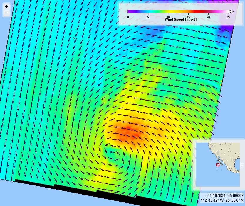


July 5, 2025 at 10:37 AM
Tropical Storm #Flossie, not anymore a hurricane, west of Mexico. @esaearth.esa.int acquisitions on 2025/07/04 01:29 & 13:07 UTC, for #2025SHOC from Copernicus #Sentinel1 C. First acquisitions of a tropical storm by Sentinel-1 C for CYMS! (Max sustained wind velocities slightly above 18 m/s)
Hurricane #Flossie west of Mexico. @esaearth.esa.int
acquisitions on 2025/07/02 13:07 UTC, for #2025SHOC from Copernicus #Sentinel1 A. Max sustained wind velocities (left) nearing 55 m/s, derived from SAR sea surface roughness (right).
acquisitions on 2025/07/02 13:07 UTC, for #2025SHOC from Copernicus #Sentinel1 A. Max sustained wind velocities (left) nearing 55 m/s, derived from SAR sea surface roughness (right).


July 3, 2025 at 10:12 AM
Hurricane #Flossie west of Mexico. @esaearth.esa.int
acquisitions on 2025/07/02 13:07 UTC, for #2025SHOC from Copernicus #Sentinel1 A. Max sustained wind velocities (left) nearing 55 m/s, derived from SAR sea surface roughness (right).
acquisitions on 2025/07/02 13:07 UTC, for #2025SHOC from Copernicus #Sentinel1 A. Max sustained wind velocities (left) nearing 55 m/s, derived from SAR sea surface roughness (right).