


Cédric Vidonne
@cvidonne.bsky.social
Information Management Officer at UNHCR specialized in #DataViz and #maps. Love #rstats stuff, especially making charts with #ggplot2.
Couldn’t resist doing the same for countries of asylum.
Turns out the picture is way more stable, with a few ups and downs.
Turns out the picture is way more stable, with a few ups and downs.

September 10, 2025 at 7:57 AM
Couldn’t resist doing the same for countries of asylum.
Turns out the picture is way more stable, with a few ups and downs.
Turns out the picture is way more stable, with a few ups and downs.
Inspired by @nrennie.bsky.social excellent #TidyTuesday plot on the power of passports, I adapted the idea to look at refugee origins.
This chart ranks countries of origin of refugees, asylum-seekers, and others in need of international protection, grouped by region.
#RStats #ggplot2 #Refugees
This chart ranks countries of origin of refugees, asylum-seekers, and others in need of international protection, grouped by region.
#RStats #ggplot2 #Refugees

September 10, 2025 at 7:14 AM
Inspired by @nrennie.bsky.social excellent #TidyTuesday plot on the power of passports, I adapted the idea to look at refugee origins.
This chart ranks countries of origin of refugees, asylum-seekers, and others in need of international protection, grouped by region.
#RStats #ggplot2 #Refugees
This chart ranks countries of origin of refugees, asylum-seekers, and others in need of international protection, grouped by region.
#RStats #ggplot2 #Refugees
The Learning Divide
Our latest data story explores the stark educational challenges facing refugees in Mauritania and Mexico.
Explore the full story: dataviz.unhcr.org/product-gall...
#refugees #education #unhcr #dataviz
Our latest data story explores the stark educational challenges facing refugees in Mauritania and Mexico.
Explore the full story: dataviz.unhcr.org/product-gall...
#refugees #education #unhcr #dataviz
April 5, 2025 at 8:11 AM
The Learning Divide
Our latest data story explores the stark educational challenges facing refugees in Mauritania and Mexico.
Explore the full story: dataviz.unhcr.org/product-gall...
#refugees #education #unhcr #dataviz
Our latest data story explores the stark educational challenges facing refugees in Mauritania and Mexico.
Explore the full story: dataviz.unhcr.org/product-gall...
#refugees #education #unhcr #dataviz
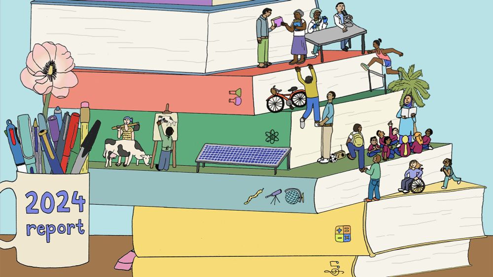
🌍 #30DayMapChallenge 2024 completed!
I’m proud to share a visual summary of all 30 maps I created this year! Nearly all maps were crafted in #rstats, showcasing themes from my work with @unhcr.org and some focused on Switzerland.
Full collection: shorturl.at/fgRlS
#maps #gis #dataviz
I’m proud to share a visual summary of all 30 maps I created this year! Nearly all maps were crafted in #rstats, showcasing themes from my work with @unhcr.org and some focused on Switzerland.
Full collection: shorturl.at/fgRlS
#maps #gis #dataviz

December 13, 2024 at 12:43 PM
🌍 #30DayMapChallenge 2024 completed!
I’m proud to share a visual summary of all 30 maps I created this year! Nearly all maps were crafted in #rstats, showcasing themes from my work with @unhcr.org and some focused on Switzerland.
Full collection: shorturl.at/fgRlS
#maps #gis #dataviz
I’m proud to share a visual summary of all 30 maps I created this year! Nearly all maps were crafted in #rstats, showcasing themes from my work with @unhcr.org and some focused on Switzerland.
Full collection: shorturl.at/fgRlS
#maps #gis #dataviz
🌍 #30DayMapChallenge Day 30: Final Map!
Wrapping up the challenge with a tribute to Swiss cartographer Eduard Imhof’s iconic style created entirely in #rstats!
A big thanks to John Nelson for his inspiring guidance on recreating Imhof's style and @drxeo.eu for making hillshade creation a breeze.
Wrapping up the challenge with a tribute to Swiss cartographer Eduard Imhof’s iconic style created entirely in #rstats!
A big thanks to John Nelson for his inspiring guidance on recreating Imhof's style and @drxeo.eu for making hillshade creation a breeze.

November 30, 2024 at 9:22 AM
🌍 #30DayMapChallenge Day 30: Final Map!
Wrapping up the challenge with a tribute to Swiss cartographer Eduard Imhof’s iconic style created entirely in #rstats!
A big thanks to John Nelson for his inspiring guidance on recreating Imhof's style and @drxeo.eu for making hillshade creation a breeze.
Wrapping up the challenge with a tribute to Swiss cartographer Eduard Imhof’s iconic style created entirely in #rstats!
A big thanks to John Nelson for his inspiring guidance on recreating Imhof's style and @drxeo.eu for making hillshade creation a breeze.
🌍 #30DayMapChallenge Day 29: Overture Data
A minimalist take on Geneva's building footprint, highlighting how natural features like the lake capture attention.
Code: shorturl.at/l6cvQ
#maps #GIS #rstats
A minimalist take on Geneva's building footprint, highlighting how natural features like the lake capture attention.
Code: shorturl.at/l6cvQ
#maps #GIS #rstats

November 29, 2024 at 9:07 AM
🌍 #30DayMapChallenge Day 29: Overture Data
A minimalist take on Geneva's building footprint, highlighting how natural features like the lake capture attention.
Code: shorturl.at/l6cvQ
#maps #GIS #rstats
A minimalist take on Geneva's building footprint, highlighting how natural features like the lake capture attention.
Code: shorturl.at/l6cvQ
#maps #GIS #rstats
🌍 #30DayMapChallenge Day 28: The Blue Planet
A different take on today’s theme—mapping @unhcr.org global presence! This map highlights 649 UNHCR offices across 146 countries, each working tirelessly to support people forced to flee.
Code: shorturl.at/vMG9m
#maps #GIS #rstats #refugees
A different take on today’s theme—mapping @unhcr.org global presence! This map highlights 649 UNHCR offices across 146 countries, each working tirelessly to support people forced to flee.
Code: shorturl.at/vMG9m
#maps #GIS #rstats #refugees

November 28, 2024 at 8:14 AM
🌍 #30DayMapChallenge Day 28: The Blue Planet
A different take on today’s theme—mapping @unhcr.org global presence! This map highlights 649 UNHCR offices across 146 countries, each working tirelessly to support people forced to flee.
Code: shorturl.at/vMG9m
#maps #GIS #rstats #refugees
A different take on today’s theme—mapping @unhcr.org global presence! This map highlights 649 UNHCR offices across 146 countries, each working tirelessly to support people forced to flee.
Code: shorturl.at/vMG9m
#maps #GIS #rstats #refugees
🌍 #30DayMapChallenge Day 27: Micromapping
Zooming in on the Mbera Refugee Camp in Mauritania, today’s map highlights essential infrastructure: health facilities, schools, and sanitation.
Code: shorturl.at/GpTx9
#maps #GIS #rstats
Zooming in on the Mbera Refugee Camp in Mauritania, today’s map highlights essential infrastructure: health facilities, schools, and sanitation.
Code: shorturl.at/GpTx9
#maps #GIS #rstats

November 27, 2024 at 9:00 AM
🌍 #30DayMapChallenge Day 27: Micromapping
Zooming in on the Mbera Refugee Camp in Mauritania, today’s map highlights essential infrastructure: health facilities, schools, and sanitation.
Code: shorturl.at/GpTx9
#maps #GIS #rstats
Zooming in on the Mbera Refugee Camp in Mauritania, today’s map highlights essential infrastructure: health facilities, schools, and sanitation.
Code: shorturl.at/GpTx9
#maps #GIS #rstats
🌍 #30DayMapChallenge Day 26: Map Projection
Today’s maps explore global sea surface temperatures in January and July 2024, using the Spilhaus projection. Big thanks to github.com/rtlemos/spil... for enabling this unique projection in R!
Code: shorturl.at/pKC2S
#maps #GIS #rstats
Today’s maps explore global sea surface temperatures in January and July 2024, using the Spilhaus projection. Big thanks to github.com/rtlemos/spil... for enabling this unique projection in R!
Code: shorturl.at/pKC2S
#maps #GIS #rstats

November 26, 2024 at 7:14 AM
🌍 #30DayMapChallenge Day 26: Map Projection
Today’s maps explore global sea surface temperatures in January and July 2024, using the Spilhaus projection. Big thanks to github.com/rtlemos/spil... for enabling this unique projection in R!
Code: shorturl.at/pKC2S
#maps #GIS #rstats
Today’s maps explore global sea surface temperatures in January and July 2024, using the Spilhaus projection. Big thanks to github.com/rtlemos/spil... for enabling this unique projection in R!
Code: shorturl.at/pKC2S
#maps #GIS #rstats
🌍 #30DayMapChallenge Day 25: Heat
This globe map, in orthographic projection, shows the temperature anomaly for the month of July 2024, highlighting the regions most impacted by the heat. Inspired by @drxeo.eu and @milos-makes-maps.bsky.social tutorials.
Code: shorturl.at/fuBqY
#maps #GIS #rstats
This globe map, in orthographic projection, shows the temperature anomaly for the month of July 2024, highlighting the regions most impacted by the heat. Inspired by @drxeo.eu and @milos-makes-maps.bsky.social tutorials.
Code: shorturl.at/fuBqY
#maps #GIS #rstats

November 25, 2024 at 10:27 AM
🌍 #30DayMapChallenge Day 25: Heat
This globe map, in orthographic projection, shows the temperature anomaly for the month of July 2024, highlighting the regions most impacted by the heat. Inspired by @drxeo.eu and @milos-makes-maps.bsky.social tutorials.
Code: shorturl.at/fuBqY
#maps #GIS #rstats
This globe map, in orthographic projection, shows the temperature anomaly for the month of July 2024, highlighting the regions most impacted by the heat. Inspired by @drxeo.eu and @milos-makes-maps.bsky.social tutorials.
Code: shorturl.at/fuBqY
#maps #GIS #rstats
🌍 #30DayMapChallenge Day 24: Only circular shapes
Inspired by @bjnnowak.bsky.social work, today's map visualizes displacement across Africa in 2024. Each bubble is split to contrast those displaced within a country with those who have sought refuge there.
Code: shorturl.at/TZMkZ
#maps #rstats
Inspired by @bjnnowak.bsky.social work, today's map visualizes displacement across Africa in 2024. Each bubble is split to contrast those displaced within a country with those who have sought refuge there.
Code: shorturl.at/TZMkZ
#maps #rstats

November 24, 2024 at 9:18 AM
🌍 #30DayMapChallenge Day 24: Only circular shapes
Inspired by @bjnnowak.bsky.social work, today's map visualizes displacement across Africa in 2024. Each bubble is split to contrast those displaced within a country with those who have sought refuge there.
Code: shorturl.at/TZMkZ
#maps #rstats
Inspired by @bjnnowak.bsky.social work, today's map visualizes displacement across Africa in 2024. Each bubble is split to contrast those displaced within a country with those who have sought refuge there.
Code: shorturl.at/TZMkZ
#maps #rstats
🌍 #30DayMapChallenge Day 23: Memory
Today’s map captures the places I’ve lived and the locations I’ve visited on mission throughout my UN career.
Code: shorturl.at/cVjvT
#maps #GIS #rstats
Today’s map captures the places I’ve lived and the locations I’ve visited on mission throughout my UN career.
Code: shorturl.at/cVjvT
#maps #GIS #rstats

November 23, 2024 at 8:08 AM
🌍 #30DayMapChallenge Day 23: Memory
Today’s map captures the places I’ve lived and the locations I’ve visited on mission throughout my UN career.
Code: shorturl.at/cVjvT
#maps #GIS #rstats
Today’s map captures the places I’ve lived and the locations I’ve visited on mission throughout my UN career.
Code: shorturl.at/cVjvT
#maps #GIS #rstats
🌍 #30DayMapChallenge Day 22: Two Colors
Today’s map is a tribute to simplicity (or laziness) and symbolism—a representation of Switzerland using just red and white, reflecting the iconic Swiss flag.
Code: shorturl.at/UVEVE
#maps #GIS #rstats
Today’s map is a tribute to simplicity (or laziness) and symbolism—a representation of Switzerland using just red and white, reflecting the iconic Swiss flag.
Code: shorturl.at/UVEVE
#maps #GIS #rstats

November 22, 2024 at 8:30 AM
🌍 #30DayMapChallenge Day 22: Two Colors
Today’s map is a tribute to simplicity (or laziness) and symbolism—a representation of Switzerland using just red and white, reflecting the iconic Swiss flag.
Code: shorturl.at/UVEVE
#maps #GIS #rstats
Today’s map is a tribute to simplicity (or laziness) and symbolism—a representation of Switzerland using just red and white, reflecting the iconic Swiss flag.
Code: shorturl.at/UVEVE
#maps #GIS #rstats
Just in time for the #30DayMapChallenge, I received two stunning beauties: Mappemondes and Le Blanc des Cartes, both featuring the incredible work of @xemartinlaborde.bsky.social Their creativity and design are on another level—makes me feel like I'm barely scribbling in comparison.

November 21, 2024 at 8:26 PM
Just in time for the #30DayMapChallenge, I received two stunning beauties: Mappemondes and Le Blanc des Cartes, both featuring the incredible work of @xemartinlaborde.bsky.social Their creativity and design are on another level—makes me feel like I'm barely scribbling in comparison.
🌍 #30DayMapChallenge Day 21: Conflict
Today’s map visualizes the intensity of conflict in Ukraine, where more than 2,240 events were reported in just the first 15 days of November 2024.
Code: shorturl.at/wLIBR
#maps #GIS #rstats
Today’s map visualizes the intensity of conflict in Ukraine, where more than 2,240 events were reported in just the first 15 days of November 2024.
Code: shorturl.at/wLIBR
#maps #GIS #rstats

November 21, 2024 at 10:33 AM
🌍 #30DayMapChallenge Day 21: Conflict
Today’s map visualizes the intensity of conflict in Ukraine, where more than 2,240 events were reported in just the first 15 days of November 2024.
Code: shorturl.at/wLIBR
#maps #GIS #rstats
Today’s map visualizes the intensity of conflict in Ukraine, where more than 2,240 events were reported in just the first 15 days of November 2024.
Code: shorturl.at/wLIBR
#maps #GIS #rstats
🌍 #30DayMapChallenge Day 20: OpenStreetMap
Today’s map highlights the city of Bern, Switzerland, crafted using OpenStreetMap data.
Code: shorturl.at/DkKlw
#maps #OSM #GIS #rstats
Today’s map highlights the city of Bern, Switzerland, crafted using OpenStreetMap data.
Code: shorturl.at/DkKlw
#maps #OSM #GIS #rstats

November 20, 2024 at 10:30 AM
🌍 #30DayMapChallenge Day 20: OpenStreetMap
Today’s map highlights the city of Bern, Switzerland, crafted using OpenStreetMap data.
Code: shorturl.at/DkKlw
#maps #OSM #GIS #rstats
Today’s map highlights the city of Bern, Switzerland, crafted using OpenStreetMap data.
Code: shorturl.at/DkKlw
#maps #OSM #GIS #rstats
🌍 #30DayMapChallenge Day 19: Typography
Combining typography and Swiss history: Münchenstein, birthplace of the iconic Helvetica font in 1957, and Rütli Meadow, where the Swiss Confederation was founded in 1291.
Code: shorturl.at/9k6hT
#maps #GIS #rstats
Combining typography and Swiss history: Münchenstein, birthplace of the iconic Helvetica font in 1957, and Rütli Meadow, where the Swiss Confederation was founded in 1291.
Code: shorturl.at/9k6hT
#maps #GIS #rstats
![A stylized map of Switzerland titled "HELVETI[c]A," with the subtitle "Swiss Design, Swiss History." The map highlights two locations: Münchenstein, labeled "Münchenstein – Birthplace of the Font Helvetica, 1957," and Rütli Meadow, labeled "Rütli Meadow – Birthplace of Confoederatio Helvetica, 1291." Helvetica font is used throughout, with selective bold and italic styles to emphasize place names and dates. The design nods to Swiss national colors, with a clean, minimalist style inspired by Swiss design principles.](https://cdn.bsky.app/img/feed_thumbnail/plain/did:plc:g5n4fmis4pkozdv2g7bnqqfo/bafkreif2flnud667lwskl77ikkbzcj34r4uxitmoeaq2l67j6ruxxk7fjy@jpeg)
November 19, 2024 at 8:47 AM
🌍 #30DayMapChallenge Day 19: Typography
Combining typography and Swiss history: Münchenstein, birthplace of the iconic Helvetica font in 1957, and Rütli Meadow, where the Swiss Confederation was founded in 1291.
Code: shorturl.at/9k6hT
#maps #GIS #rstats
Combining typography and Swiss history: Münchenstein, birthplace of the iconic Helvetica font in 1957, and Rütli Meadow, where the Swiss Confederation was founded in 1291.
Code: shorturl.at/9k6hT
#maps #GIS #rstats
🌍 #30DayMapChallenge Day 18: 3D!
My first attempt at a 3D map: forest cover in Switzerland! 🌲
Turns out, 3D is tricky, but it’s been a great learning experience. Big thanks to @milos-makes-maps.bsky.social for the tutorials—they were a huge help!
Code: shorturl.at/FO3dw
#maps #GIS #rstats
My first attempt at a 3D map: forest cover in Switzerland! 🌲
Turns out, 3D is tricky, but it’s been a great learning experience. Big thanks to @milos-makes-maps.bsky.social for the tutorials—they were a huge help!
Code: shorturl.at/FO3dw
#maps #GIS #rstats

November 18, 2024 at 10:45 AM
🌍 #30DayMapChallenge Day 18: 3D!
My first attempt at a 3D map: forest cover in Switzerland! 🌲
Turns out, 3D is tricky, but it’s been a great learning experience. Big thanks to @milos-makes-maps.bsky.social for the tutorials—they were a huge help!
Code: shorturl.at/FO3dw
#maps #GIS #rstats
My first attempt at a 3D map: forest cover in Switzerland! 🌲
Turns out, 3D is tricky, but it’s been a great learning experience. Big thanks to @milos-makes-maps.bsky.social for the tutorials—they were a huge help!
Code: shorturl.at/FO3dw
#maps #GIS #rstats
🌍 #30DayMapChallenge Day 17: Collaborative Map!
Today’s map was a family creation! Using LEGO bricks, my kids and I built a map of Switzerland highlighting its four distinct language regions: German, French, Italian, and Romansh.
#maps #LEGO
Today’s map was a family creation! Using LEGO bricks, my kids and I built a map of Switzerland highlighting its four distinct language regions: German, French, Italian, and Romansh.
#maps #LEGO

November 17, 2024 at 9:28 AM
🌍 #30DayMapChallenge Day 17: Collaborative Map!
Today’s map was a family creation! Using LEGO bricks, my kids and I built a map of Switzerland highlighting its four distinct language regions: German, French, Italian, and Romansh.
#maps #LEGO
Today’s map was a family creation! Using LEGO bricks, my kids and I built a map of Switzerland highlighting its four distinct language regions: German, French, Italian, and Romansh.
#maps #LEGO
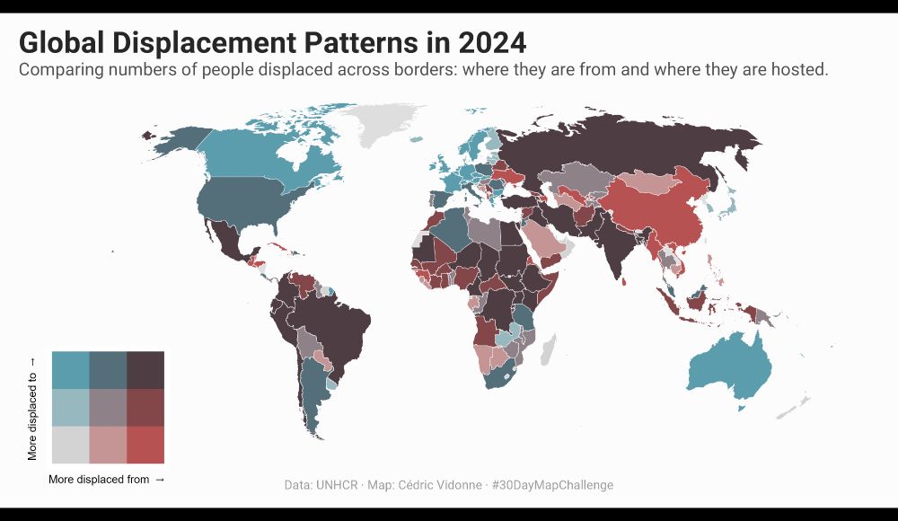
🌍 #30DayMapChallenge Day 16: Choropleth!
This bivariate choropleth highlights the complex flows of forced migration around the world, providing a view into both the origins and destinations of displaced communities.
Code: shorturl.at/rLbbg
#maps #GIS #rstats
This bivariate choropleth highlights the complex flows of forced migration around the world, providing a view into both the origins and destinations of displaced communities.
Code: shorturl.at/rLbbg
#maps #GIS #rstats
November 16, 2024 at 8:46 AM
🌍 #30DayMapChallenge Day 16: Choropleth!
This bivariate choropleth highlights the complex flows of forced migration around the world, providing a view into both the origins and destinations of displaced communities.
Code: shorturl.at/rLbbg
#maps #GIS #rstats
This bivariate choropleth highlights the complex flows of forced migration around the world, providing a view into both the origins and destinations of displaced communities.
Code: shorturl.at/rLbbg
#maps #GIS #rstats
🏊🚴🏃 #30DayMapChallenge Day 15: My Data!
Today’s map dives into a personal milestone—my Ironman Copenhagen 2021 journey!
Code: shorturl.at/RSvqz
#maps #GIS #rstats
Today’s map dives into a personal milestone—my Ironman Copenhagen 2021 journey!
Code: shorturl.at/RSvqz
#maps #GIS #rstats

November 15, 2024 at 9:13 AM
🏊🚴🏃 #30DayMapChallenge Day 15: My Data!
Today’s map dives into a personal milestone—my Ironman Copenhagen 2021 journey!
Code: shorturl.at/RSvqz
#maps #GIS #rstats
Today’s map dives into a personal milestone—my Ironman Copenhagen 2021 journey!
Code: shorturl.at/RSvqz
#maps #GIS #rstats
🌍 #30DayMapChallenge Day 14: World
Today’s map explores the global availability of Common Operational Datasets (CODs). CODs are essential for humanitarian response, providing reliable geographic data to support crisis preparedness and coordination.
Code: shorturl.at/IyKO0
#maps #GIS #rstats
Today’s map explores the global availability of Common Operational Datasets (CODs). CODs are essential for humanitarian response, providing reliable geographic data to support crisis preparedness and coordination.
Code: shorturl.at/IyKO0
#maps #GIS #rstats

November 14, 2024 at 9:21 AM
🌍 #30DayMapChallenge Day 14: World
Today’s map explores the global availability of Common Operational Datasets (CODs). CODs are essential for humanitarian response, providing reliable geographic data to support crisis preparedness and coordination.
Code: shorturl.at/IyKO0
#maps #GIS #rstats
Today’s map explores the global availability of Common Operational Datasets (CODs). CODs are essential for humanitarian response, providing reliable geographic data to support crisis preparedness and coordination.
Code: shorturl.at/IyKO0
#maps #GIS #rstats
🌍 #30DayMapChallenge Day 13: New Tool!
Third take on population density in Switzerland, this time using Bertin.js to create a spike map! Impressed by the functionality of this library.
Code: shorturl.at/ZMuWx
#maps #GIS #bertinjs #quarto
Third take on population density in Switzerland, this time using Bertin.js to create a spike map! Impressed by the functionality of this library.
Code: shorturl.at/ZMuWx
#maps #GIS #bertinjs #quarto

November 13, 2024 at 1:28 PM
🌍 #30DayMapChallenge Day 13: New Tool!
Third take on population density in Switzerland, this time using Bertin.js to create a spike map! Impressed by the functionality of this library.
Code: shorturl.at/ZMuWx
#maps #GIS #bertinjs #quarto
Third take on population density in Switzerland, this time using Bertin.js to create a spike map! Impressed by the functionality of this library.
Code: shorturl.at/ZMuWx
#maps #GIS #bertinjs #quarto
🌍 #30DayMapChallenge Day 12: Time & Space!
Today, I’m exploring refugee arrival trends in EU countries over the past 30 years. This geofacetted line chart captures the evolution of arrivals, showing how patterns have shifted within the EU.
Code: shorturl.at/gWEwr
#maps #GIS #rstats
Today, I’m exploring refugee arrival trends in EU countries over the past 30 years. This geofacetted line chart captures the evolution of arrivals, showing how patterns have shifted within the EU.
Code: shorturl.at/gWEwr
#maps #GIS #rstats

November 12, 2024 at 10:54 AM
🌍 #30DayMapChallenge Day 12: Time & Space!
Today, I’m exploring refugee arrival trends in EU countries over the past 30 years. This geofacetted line chart captures the evolution of arrivals, showing how patterns have shifted within the EU.
Code: shorturl.at/gWEwr
#maps #GIS #rstats
Today, I’m exploring refugee arrival trends in EU countries over the past 30 years. This geofacetted line chart captures the evolution of arrivals, showing how patterns have shifted within the EU.
Code: shorturl.at/gWEwr
#maps #GIS #rstats
🌍 #30DayMapChallenge Day 11: Arctic (or Almost!)
For today, I’m taking a detour from the Arctic to Switzerland’s own glaciers, comparing their extent in 1850 and 2016.
Code: shorturl.at/J25lc
#maps #GIS #rstats
For today, I’m taking a detour from the Arctic to Switzerland’s own glaciers, comparing their extent in 1850 and 2016.
Code: shorturl.at/J25lc
#maps #GIS #rstats

November 11, 2024 at 8:53 AM
🌍 #30DayMapChallenge Day 11: Arctic (or Almost!)
For today, I’m taking a detour from the Arctic to Switzerland’s own glaciers, comparing their extent in 1850 and 2016.
Code: shorturl.at/J25lc
#maps #GIS #rstats
For today, I’m taking a detour from the Arctic to Switzerland’s own glaciers, comparing their extent in 1850 and 2016.
Code: shorturl.at/J25lc
#maps #GIS #rstats