


CrosswalkCrusader
@crosswalkcrusader.bsky.social
The peoples’ hero. Fiercely fighting for pedestrian rights. Pro transit, pro sensible regulation. Boston.
The view from the new Bill Russell N Washington bridge. Very nice bike lane!
Miles better than the experience on the old bridge
Miles better than the experience on the old bridge

November 16, 2025 at 1:29 PM
The view from the new Bill Russell N Washington bridge. Very nice bike lane!
Miles better than the experience on the old bridge
Miles better than the experience on the old bridge
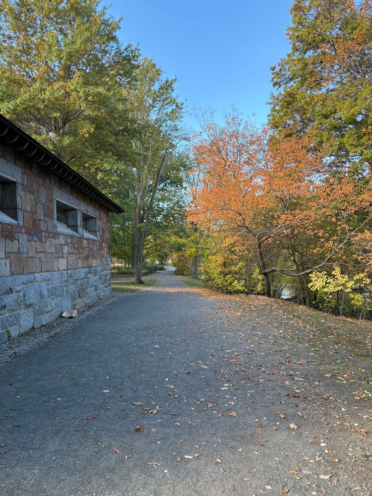
Fall stroll
October 27, 2025 at 3:33 PM
Fall stroll
I love walking through the fens but it’s clear that we prioritize cars over people when we reopen Agassiz as an unnecessary cut through while the walking trail doesn’t have a curb cut or crosswalk

October 27, 2025 at 3:33 PM
I love walking through the fens but it’s clear that we prioritize cars over people when we reopen Agassiz as an unnecessary cut through while the walking trail doesn’t have a curb cut or crosswalk
It seems like the lowest hanging fruit to shrink Memorial to one lane in each direction between the Longfellow and River street.
By MIT it would free up acres of usable parkland that is currently a median
By MIT it would free up acres of usable parkland that is currently a median

September 9, 2025 at 5:19 PM
It seems like the lowest hanging fruit to shrink Memorial to one lane in each direction between the Longfellow and River street.
By MIT it would free up acres of usable parkland that is currently a median
By MIT it would free up acres of usable parkland that is currently a median
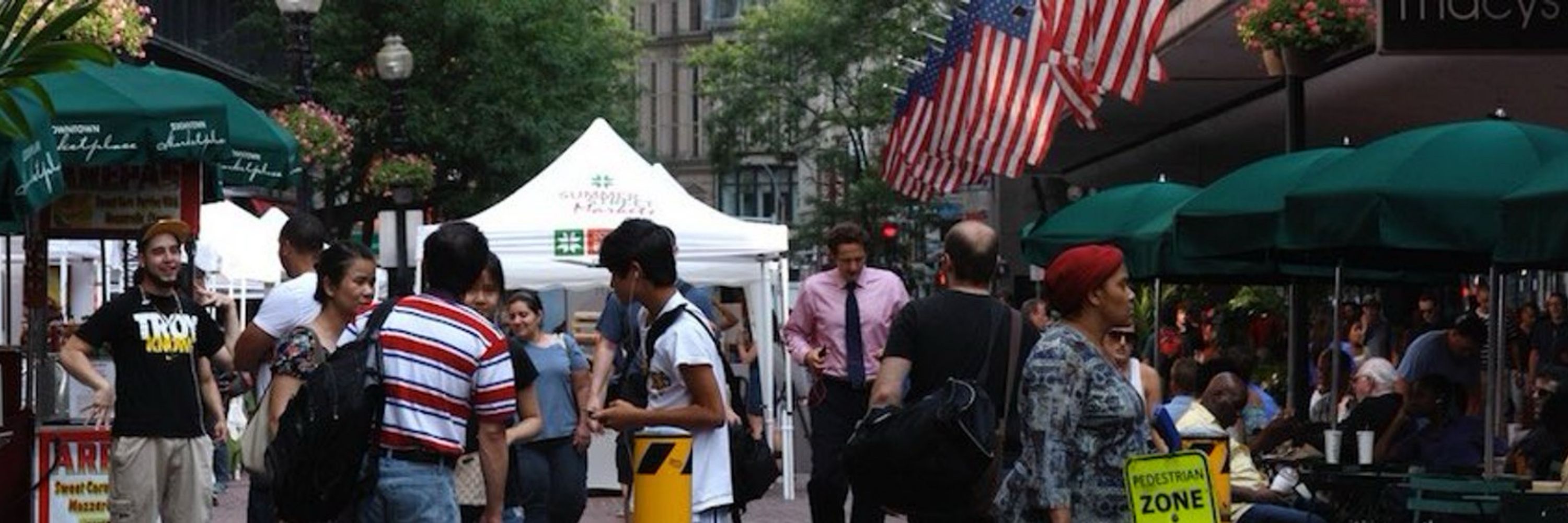
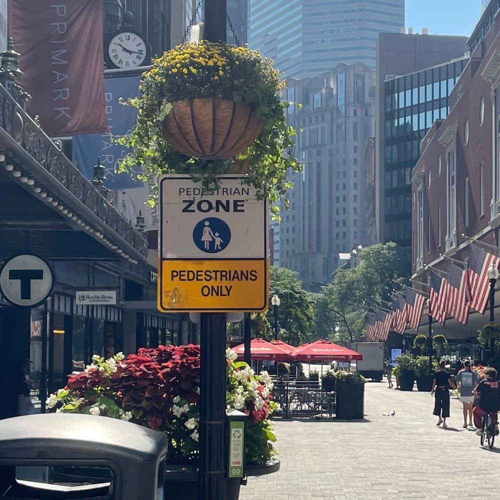
I think I remember there being flexposts which confused me. It is a nice bike lane - Comm Ave could use the same treatment!
I know the Arlington intersection has an overhaul planned but getting there from the Public Garden is not easy yet!
Nice all-walk at Berkeley allowed easy crossing tho
I know the Arlington intersection has an overhaul planned but getting there from the Public Garden is not easy yet!
Nice all-walk at Berkeley allowed easy crossing tho

September 2, 2025 at 2:35 AM
I think I remember there being flexposts which confused me. It is a nice bike lane - Comm Ave could use the same treatment!
I know the Arlington intersection has an overhaul planned but getting there from the Public Garden is not easy yet!
Nice all-walk at Berkeley allowed easy crossing tho
I know the Arlington intersection has an overhaul planned but getting there from the Public Garden is not easy yet!
Nice all-walk at Berkeley allowed easy crossing tho
What’s a better use for the space under Charles MGH than 9 lanes of pavement?

August 22, 2025 at 3:13 AM
What’s a better use for the space under Charles MGH than 9 lanes of pavement?
Giving Goldeneye vibes.
For England, James?
For England, James?

August 21, 2025 at 1:25 AM
Giving Goldeneye vibes.
For England, James?
For England, James?
Drawing overlay below! (assumption all roads are staying, otherwise SFR and Nonantum should go):
Ive heard DCR is planning a community center so this is included this but not much thought into vehicle access for loading. Parking lot for it tucked behind ihop.
Plan involves 2 land takings
Ive heard DCR is planning a community center so this is included this but not much thought into vehicle access for loading. Parking lot for it tucked behind ihop.
Plan involves 2 land takings

August 19, 2025 at 6:52 PM
Drawing overlay below! (assumption all roads are staying, otherwise SFR and Nonantum should go):
Ive heard DCR is planning a community center so this is included this but not much thought into vehicle access for loading. Parking lot for it tucked behind ihop.
Plan involves 2 land takings
Ive heard DCR is planning a community center so this is included this but not much thought into vehicle access for loading. Parking lot for it tucked behind ihop.
Plan involves 2 land takings
A few months ago the DCR came out with a horrible design for the below intersection, featuring a 6 lane highway. Below should be feasible with 4 lanes in the trunk down from 8 today.
Will attempt to learn a mapping software to show turning lanes!
3 phases covering both main intersections.
Will attempt to learn a mapping software to show turning lanes!
3 phases covering both main intersections.

August 18, 2025 at 3:24 AM
A few months ago the DCR came out with a horrible design for the below intersection, featuring a 6 lane highway. Below should be feasible with 4 lanes in the trunk down from 8 today.
Will attempt to learn a mapping software to show turning lanes!
3 phases covering both main intersections.
Will attempt to learn a mapping software to show turning lanes!
3 phases covering both main intersections.
Giant clusterfuck.
Day Blvd incorporated into the park and removed from intersection. Morrissey Blvd bridge removed to support a road diet from 10 lanes to 4. 2 lane access road in front of commercial south of JFK connects with Morrissey around BC High.
Silver bus lane to JFK
Day Blvd incorporated into the park and removed from intersection. Morrissey Blvd bridge removed to support a road diet from 10 lanes to 4. 2 lane access road in front of commercial south of JFK connects with Morrissey around BC High.
Silver bus lane to JFK

August 17, 2025 at 3:18 AM
Giant clusterfuck.
Day Blvd incorporated into the park and removed from intersection. Morrissey Blvd bridge removed to support a road diet from 10 lanes to 4. 2 lane access road in front of commercial south of JFK connects with Morrissey around BC High.
Silver bus lane to JFK
Day Blvd incorporated into the park and removed from intersection. Morrissey Blvd bridge removed to support a road diet from 10 lanes to 4. 2 lane access road in front of commercial south of JFK connects with Morrissey around BC High.
Silver bus lane to JFK
Two separate off ramps feeding into a popular tourist area creates congestion.
Clinton St (Blue east) one lane & North St (black west) two lanes one way from Congress to Surface Road. Losing the opposite lane allows space for a nice bike lane (green).
Clinton St (Blue east) one lane & North St (black west) two lanes one way from Congress to Surface Road. Losing the opposite lane allows space for a nice bike lane (green).

August 16, 2025 at 5:12 PM
Two separate off ramps feeding into a popular tourist area creates congestion.
Clinton St (Blue east) one lane & North St (black west) two lanes one way from Congress to Surface Road. Losing the opposite lane allows space for a nice bike lane (green).
Clinton St (Blue east) one lane & North St (black west) two lanes one way from Congress to Surface Road. Losing the opposite lane allows space for a nice bike lane (green).
No one wins when there are downtown highway off-ramps.
Improve things somewhat by keeping Seaport boulevard exit away from Purchase Street and South Station exit away from Summer Street.
Improve things somewhat by keeping Seaport boulevard exit away from Purchase Street and South Station exit away from Summer Street.


August 16, 2025 at 1:00 PM
No one wins when there are downtown highway off-ramps.
Improve things somewhat by keeping Seaport boulevard exit away from Purchase Street and South Station exit away from Summer Street.
Improve things somewhat by keeping Seaport boulevard exit away from Purchase Street and South Station exit away from Summer Street.
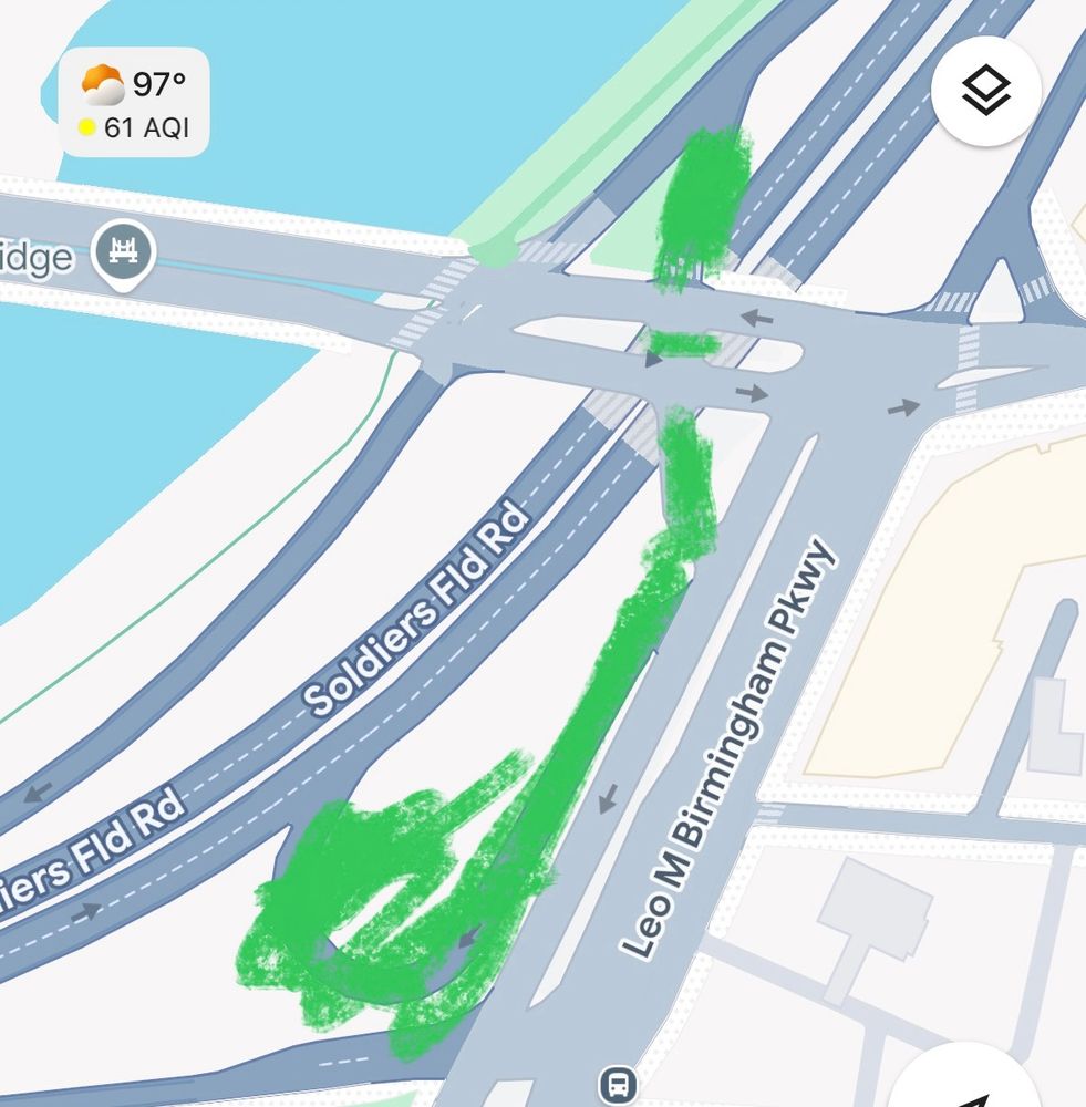
Wherever there is traffic in Boston, there is a spaghetti intersection where traffic engineers overbuild because they refuse to tell people they can’t go left.
Remove the connection from Storrow to the bridge (can get on memorial earlier or use Nashua St), 93 to 28 (can use N Washington)
Remove the connection from Storrow to the bridge (can get on memorial earlier or use Nashua St), 93 to 28 (can use N Washington)

August 15, 2025 at 1:14 PM
Wherever there is traffic in Boston, there is a spaghetti intersection where traffic engineers overbuild because they refuse to tell people they can’t go left.
Remove the connection from Storrow to the bridge (can get on memorial earlier or use Nashua St), 93 to 28 (can use N Washington)
Remove the connection from Storrow to the bridge (can get on memorial earlier or use Nashua St), 93 to 28 (can use N Washington)
Per @mass.streetsblog.org , early stages on a very cool looking river crossing!
Charles River Dam road is a highway on-ramp and always car choked. Getting pedestrians and bikers away from this mess would be a positive.
Between this and Northern Ave, what gets built first?
Charles River Dam road is a highway on-ramp and always car choked. Getting pedestrians and bikers away from this mess would be a positive.
Between this and Northern Ave, what gets built first?

August 15, 2025 at 11:34 AM
Per @mass.streetsblog.org , early stages on a very cool looking river crossing!
Charles River Dam road is a highway on-ramp and always car choked. Getting pedestrians and bikers away from this mess would be a positive.
Between this and Northern Ave, what gets built first?
Charles River Dam road is a highway on-ramp and always car choked. Getting pedestrians and bikers away from this mess would be a positive.
Between this and Northern Ave, what gets built first?
River Street Crayon:
Apologies to @siguida.bsky.social , I’m still using phone markup 😂
Improve the intersection (before complete pike overhaul): Green removes 2nd pike ramp and west bound Cambridge St section except for buses/emergency (silver line). Lane from SF exit becomes expanded path
Apologies to @siguida.bsky.social , I’m still using phone markup 😂
Improve the intersection (before complete pike overhaul): Green removes 2nd pike ramp and west bound Cambridge St section except for buses/emergency (silver line). Lane from SF exit becomes expanded path

August 13, 2025 at 4:04 PM
River Street Crayon:
Apologies to @siguida.bsky.social , I’m still using phone markup 😂
Improve the intersection (before complete pike overhaul): Green removes 2nd pike ramp and west bound Cambridge St section except for buses/emergency (silver line). Lane from SF exit becomes expanded path
Apologies to @siguida.bsky.social , I’m still using phone markup 😂
Improve the intersection (before complete pike overhaul): Green removes 2nd pike ramp and west bound Cambridge St section except for buses/emergency (silver line). Lane from SF exit becomes expanded path
Charles Circle Crayon:
Remove turns under the MBTA station. Narrow Longfellow to one lane.
Remove turns under the MBTA station. Narrow Longfellow to one lane.

August 12, 2025 at 1:47 PM
Charles Circle Crayon:
Remove turns under the MBTA station. Narrow Longfellow to one lane.
Remove turns under the MBTA station. Narrow Longfellow to one lane.
Sullivan Square Redesign:
Keep the under pass, but limit turns. 99 SB exit only goes towards Assembly, not rotary. New bridge straight over tunnel to connect Main Street sections. Cambridge St one way westbound (including offramp) except buses. 99 NB surface road limited to Charlestown.
Keep the under pass, but limit turns. 99 SB exit only goes towards Assembly, not rotary. New bridge straight over tunnel to connect Main Street sections. Cambridge St one way westbound (including offramp) except buses. 99 NB surface road limited to Charlestown.

August 12, 2025 at 4:54 AM
Sullivan Square Redesign:
Keep the under pass, but limit turns. 99 SB exit only goes towards Assembly, not rotary. New bridge straight over tunnel to connect Main Street sections. Cambridge St one way westbound (including offramp) except buses. 99 NB surface road limited to Charlestown.
Keep the under pass, but limit turns. 99 SB exit only goes towards Assembly, not rotary. New bridge straight over tunnel to connect Main Street sections. Cambridge St one way westbound (including offramp) except buses. 99 NB surface road limited to Charlestown.

Mass & Cass crayon:
Remove the slip lanes and left turns!
Remove the slip lanes and left turns!

August 11, 2025 at 8:50 PM
Mass & Cass crayon:
Remove the slip lanes and left turns!
Remove the slip lanes and left turns!
Soldiers field road crayon:
Dangerous and redundant on ramp. Should be a bunch of trees
Soldiers Field WB can access Western Ave from Everett st or N Harvard further off. Don’t need both off ramps.
Dangerous and redundant on ramp. Should be a bunch of trees
Soldiers Field WB can access Western Ave from Everett st or N Harvard further off. Don’t need both off ramps.
August 11, 2025 at 8:25 PM
Soldiers field road crayon:
Dangerous and redundant on ramp. Should be a bunch of trees
Soldiers Field WB can access Western Ave from Everett st or N Harvard further off. Don’t need both off ramps.
Dangerous and redundant on ramp. Should be a bunch of trees
Soldiers Field WB can access Western Ave from Everett st or N Harvard further off. Don’t need both off ramps.
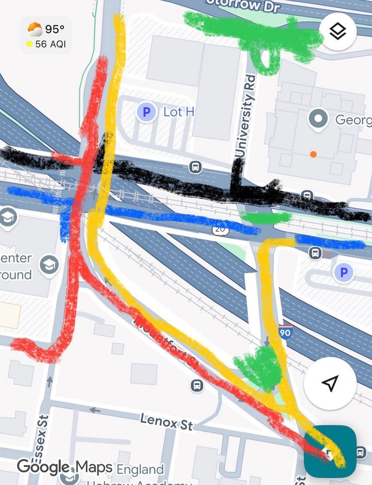
Crayon for BU bridge redesign:
Get rid of the storrow on/off to reduce overall traffic, remove Mountfort loop and multi-stage comm-ave crossings. No left turns accommodated. Carlton can be preserved for bus lane if necessary, but otherwise ped/bike crossing only. 3 phases total. Narrow Comm Ave.
Get rid of the storrow on/off to reduce overall traffic, remove Mountfort loop and multi-stage comm-ave crossings. No left turns accommodated. Carlton can be preserved for bus lane if necessary, but otherwise ped/bike crossing only. 3 phases total. Narrow Comm Ave.
August 11, 2025 at 5:25 PM
Crayon for BU bridge redesign:
Get rid of the storrow on/off to reduce overall traffic, remove Mountfort loop and multi-stage comm-ave crossings. No left turns accommodated. Carlton can be preserved for bus lane if necessary, but otherwise ped/bike crossing only. 3 phases total. Narrow Comm Ave.
Get rid of the storrow on/off to reduce overall traffic, remove Mountfort loop and multi-stage comm-ave crossings. No left turns accommodated. Carlton can be preserved for bus lane if necessary, but otherwise ped/bike crossing only. 3 phases total. Narrow Comm Ave.
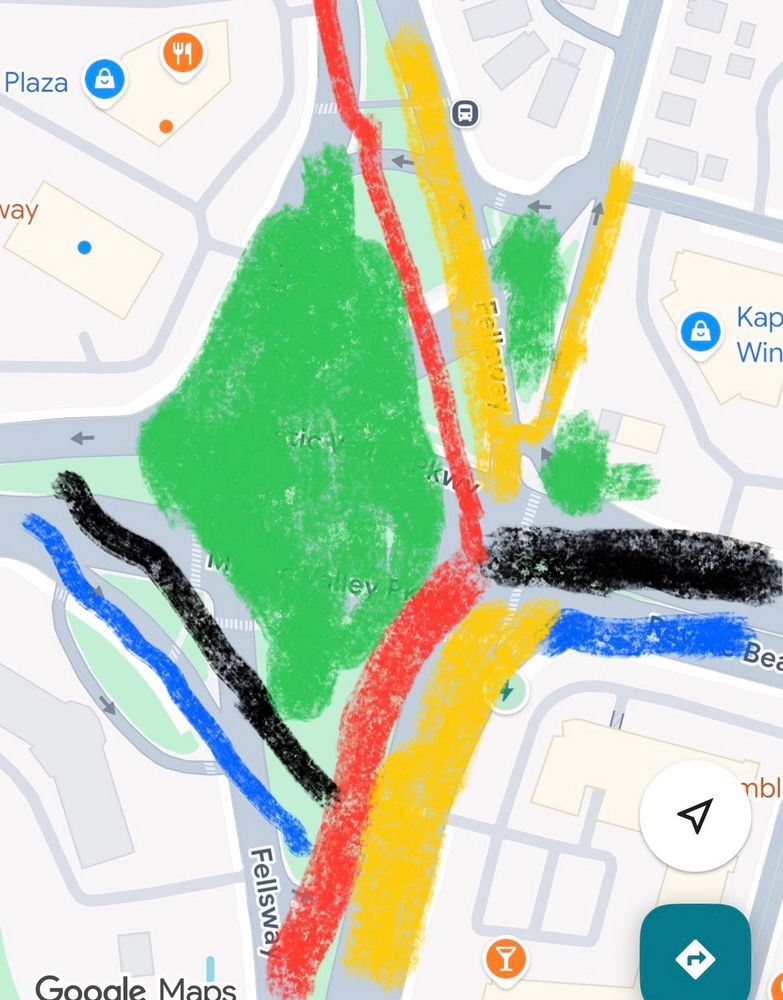
Second Wellington Circle Crayon:
Revere Beach W to Fellsway S as main priority with two intersections. Traffic would need to turn to continue in path of travel N or S. Substantial queues to turn left from Fellsway N but there is space to accommodate.
Green becomes parkland
Revere Beach W to Fellsway S as main priority with two intersections. Traffic would need to turn to continue in path of travel N or S. Substantial queues to turn left from Fellsway N but there is space to accommodate.
Green becomes parkland
August 10, 2025 at 4:50 AM
Second Wellington Circle Crayon:
Revere Beach W to Fellsway S as main priority with two intersections. Traffic would need to turn to continue in path of travel N or S. Substantial queues to turn left from Fellsway N but there is space to accommodate.
Green becomes parkland
Revere Beach W to Fellsway S as main priority with two intersections. Traffic would need to turn to continue in path of travel N or S. Substantial queues to turn left from Fellsway N but there is space to accommodate.
Green becomes parkland
Crayon for redesign of Wellington Circle: simplify the intersection by giving priority to E-W or N-S travel, remove Middlesex Ave into intersection, jug handle for turns. Mystic/Revere in center goes from 12 lanes to 4. 2 main car phases down from the dozens today so less queuing space needed.

August 10, 2025 at 4:09 AM
Crayon for redesign of Wellington Circle: simplify the intersection by giving priority to E-W or N-S travel, remove Middlesex Ave into intersection, jug handle for turns. Mystic/Revere in center goes from 12 lanes to 4. 2 main car phases down from the dozens today so less queuing space needed.
Rough sketch of a reconfig without touching 90 on/off ramps. Green 2 lanes, blue 1. Could vastly improve the Stuart and Dartmouth intersection. Pike becomes only traffic feeding Stuart. Main Huntington traffic going NE towards Copley. Red no cars, bus/bike/ped only.

August 8, 2025 at 7:06 PM
Rough sketch of a reconfig without touching 90 on/off ramps. Green 2 lanes, blue 1. Could vastly improve the Stuart and Dartmouth intersection. Pike becomes only traffic feeding Stuart. Main Huntington traffic going NE towards Copley. Red no cars, bus/bike/ped only.
This on/off ramp combination to connect Storrow with the BU campus should go. It feeds into an already crowded Comm Ave intersection and alternative car connections are readily available.
The land could be used for an accessible connection between the BU bridge and bike path.
The land could be used for an accessible connection between the BU bridge and bike path.

July 16, 2025 at 5:35 PM
This on/off ramp combination to connect Storrow with the BU campus should go. It feeds into an already crowded Comm Ave intersection and alternative car connections are readily available.
The land could be used for an accessible connection between the BU bridge and bike path.
The land could be used for an accessible connection between the BU bridge and bike path.