


Carrie Adair
@carrieis.bsky.social
GIS Geek • Cartographer working in the post wildfire landscape.
Reposted by Carrie Adair

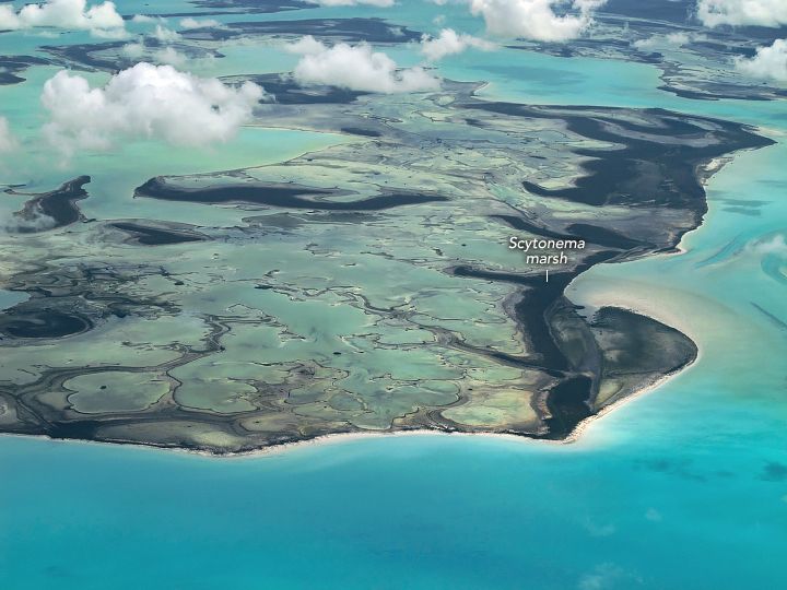
“One of the lessons from what’s happened on Andros is that the effects of sea level rise are not uniform or intuitive,” said one of the researchers, noting that the shorelines saw little change because they were adequately replenished with sediment.
November 19, 2024 at 10:46 PM
“One of the lessons from what’s happened on Andros is that the effects of sea level rise are not uniform or intuitive,” said one of the researchers, noting that the shorelines saw little change because they were adequately replenished with sediment.
Reposted by Carrie Adair
A mind-blowing thread from @rebeccarhelm.bsky.social about under-known ocean animals? Every day, Bluesky is feeling more like home. 🧪

This is SO COOL. Extremely rare soft crystalline seashells are washing up in Northern California right now [a thread 🧵]...
🦑🧪🌊🐙
🦑🧪🌊🐙

November 11, 2024 at 5:59 PM
A mind-blowing thread from @rebeccarhelm.bsky.social about under-known ocean animals? Every day, Bluesky is feeling more like home. 🧪
Reposted by Carrie Adair

Bottom Line: It is all of our interests to support NOAA's codification and funding. From academia to the entire financial sector to emergency managers to law enforcement -- NOAA is a critical agency. Strengthening the link between federal agencies and the private sector should be the goal.
4/4
4/4
November 7, 2024 at 3:32 PM
Bottom Line: It is all of our interests to support NOAA's codification and funding. From academia to the entire financial sector to emergency managers to law enforcement -- NOAA is a critical agency. Strengthening the link between federal agencies and the private sector should be the goal.
4/4
4/4
Reposted by Carrie Adair

I wish people understood how long it takes to make a map. Before the cartography, there's finding the data, then cleaning and prepping it, then any analysis you need to do. Then you get to the making it understandable. The easier the map looks, likely the more time it took to make. #gischat
November 6, 2024 at 11:50 PM
I wish people understood how long it takes to make a map. Before the cartography, there's finding the data, then cleaning and prepping it, then any analysis you need to do. Then you get to the making it understandable. The easier the map looks, likely the more time it took to make. #gischat
#30daymapchallenge | Day 5: Analog Map
This is a map of my dog Atlas's Kingdom and how his behavior influences the behavior of the neighborhood squirrels. He's our Golden Retriever/American Staffordshire mix COVID dog who hates water but loves to sit on the porch and survey his kingdom! #gisgeek
This is a map of my dog Atlas's Kingdom and how his behavior influences the behavior of the neighborhood squirrels. He's our Golden Retriever/American Staffordshire mix COVID dog who hates water but loves to sit on the porch and survey his kingdom! #gisgeek

November 5, 2023 at 5:59 PM
#30daymapchallenge | Day 5: Analog Map
This is a map of my dog Atlas's Kingdom and how his behavior influences the behavior of the neighborhood squirrels. He's our Golden Retriever/American Staffordshire mix COVID dog who hates water but loves to sit on the porch and survey his kingdom! #gisgeek
This is a map of my dog Atlas's Kingdom and how his behavior influences the behavior of the neighborhood squirrels. He's our Golden Retriever/American Staffordshire mix COVID dog who hates water but loves to sit on the porch and survey his kingdom! #gisgeek
My first post to go with the first day of the #30DayMapChallenge!
Points Global Thermal Hotspot points using #VIIRS thermal hotspots and fire activity data for the week of 10-24 through 11-1.
Points Global Thermal Hotspot points using #VIIRS thermal hotspots and fire activity data for the week of 10-24 through 11-1.

November 2, 2023 at 2:07 AM
My first post to go with the first day of the #30DayMapChallenge!
Points Global Thermal Hotspot points using #VIIRS thermal hotspots and fire activity data for the week of 10-24 through 11-1.
Points Global Thermal Hotspot points using #VIIRS thermal hotspots and fire activity data for the week of 10-24 through 11-1.