


Philip Burt
@capecodweather.net
Meteorologist talking about weather, Cape Cod, climate...interested in running, outdoorsy stuff, politics and so on and so forth
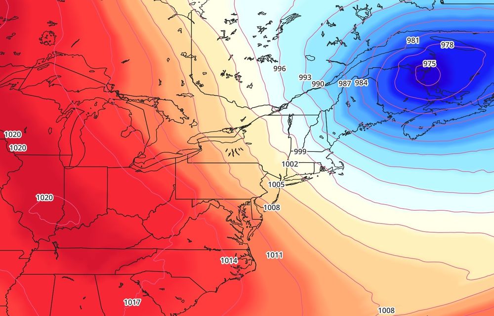
A lot of wind to contend with today and again tomorrow. Strong low pressure anchored to our northeast creating a tight pressure gradient across New England. Still breezy Tuesday but quieter mid-week as high pressure builds east
November 16, 2025 at 11:21 PM
A lot of wind to contend with today and again tomorrow. Strong low pressure anchored to our northeast creating a tight pressure gradient across New England. Still breezy Tuesday but quieter mid-week as high pressure builds east
One more because awesome. View from the Bay

November 12, 2025 at 2:40 AM
One more because awesome. View from the Bay
Could watch this all night. #northernlights

November 12, 2025 at 2:32 AM
Could watch this all night. #northernlights


Downpours and some thunderstorms crossing the area. Some very heavy rain about to impact the Outer Cape

November 10, 2025 at 12:32 AM
Downpours and some thunderstorms crossing the area. Some very heavy rain about to impact the Outer Cape
Rain overspreading the area...some downpours embedded in there and even some flashes of lightning / rumbles of thunder

November 9, 2025 at 9:49 PM
Rain overspreading the area...some downpours embedded in there and even some flashes of lightning / rumbles of thunder
Mild out there today...and we squeeze in another one tomorrow (though wet)... but much colder weather expected for the week ahead. Multiple days stuck in the 40s Tue-Sat


November 9, 2025 at 3:09 PM
Mild out there today...and we squeeze in another one tomorrow (though wet)... but much colder weather expected for the week ahead. Multiple days stuck in the 40s Tue-Sat
Windy night coming up. Gusty from the SW this evening, then post-frontal NW winds after midnight. Atmosphere becomes well mixed overnight...tapping winds in the 950-900 mb layer (45-55 knots)... add in a good pressure rise...likely to be some 50 - 60 mph gusts. Particularly on the Outer Cape

November 5, 2025 at 11:47 PM
Windy night coming up. Gusty from the SW this evening, then post-frontal NW winds after midnight. Atmosphere becomes well mixed overnight...tapping winds in the 950-900 mb layer (45-55 knots)... add in a good pressure rise...likely to be some 50 - 60 mph gusts. Particularly on the Outer Cape
Active weather pattern with a lot of wind. Next round comes tomorrow night / Thursday morning behind a rapidly deepening storm in the Gulf of Maine. Gusts 50-60+ mph likely... probably some tree/limb damage and scattered power outages to deal with

November 4, 2025 at 11:27 PM
Active weather pattern with a lot of wind. Next round comes tomorrow night / Thursday morning behind a rapidly deepening storm in the Gulf of Maine. Gusts 50-60+ mph likely... probably some tree/limb damage and scattered power outages to deal with
Two big rain events in October...good drought-denting-month. CoCoRaHS observer totals for the period:

November 2, 2025 at 12:26 AM
Two big rain events in October...good drought-denting-month. CoCoRaHS observer totals for the period:
While Hurricane Melissa will pass waaay out to sea to our SE, some of the system's tropical moisture will get dragged northward ahead of an approaching cold front Thursday and Thursday night, giving the rain a little extra boost. Some hefty downpours likely Thursday evening/night.

October 29, 2025 at 10:34 PM
While Hurricane Melissa will pass waaay out to sea to our SE, some of the system's tropical moisture will get dragged northward ahead of an approaching cold front Thursday and Thursday night, giving the rain a little extra boost. Some hefty downpours likely Thursday evening/night.

Was pretty mild today (mid 60s) but a stretch of chilly weather coming up this weekend into early next week

October 22, 2025 at 11:12 PM
Was pretty mild today (mid 60s) but a stretch of chilly weather coming up this weekend into early next week
Few showers / downpours approaching the area from the south...damp first half of the day...better in the afternoon.

October 22, 2025 at 11:12 AM
Few showers / downpours approaching the area from the south...damp first half of the day...better in the afternoon.
Quite a Cape Cod sunset

October 8, 2025 at 10:15 PM
Quite a Cape Cod sunset
Soaking rain coming up tomorrow. Good news is we need the rain. Bad news is it kills the October warmth...much cooler air moves in behind it.

October 7, 2025 at 10:48 PM
Soaking rain coming up tomorrow. Good news is we need the rain. Bad news is it kills the October warmth...much cooler air moves in behind it.
Nice shot of (Cat 4) Hurricane Humberto...several hundred miles northeast of Puerto Rico and the Virgin Islands. No threat to land at the moment...could pass near Bermuda during the early to middle part of next week.

September 27, 2025 at 1:50 PM
Nice shot of (Cat 4) Hurricane Humberto...several hundred miles northeast of Puerto Rico and the Virgin Islands. No threat to land at the moment...could pass near Bermuda during the early to middle part of next week.
Mild day coming up tomorrow (Friday). Gradual clearing and an offshore wind should send us well into the 70s. HRRR 2-m temps in the lower to middle 70s suggest 75 to 80F is in play. Still a bit humid too.

September 25, 2025 at 9:46 PM
Mild day coming up tomorrow (Friday). Gradual clearing and an offshore wind should send us well into the 70s. HRRR 2-m temps in the lower to middle 70s suggest 75 to 80F is in play. Still a bit humid too.
@joyf.bsky.social I meant to send this the other day… my first one bloomed right around 6/20… this was 9/8… weird how they can hang on. Same set of bulbs was really late last year too

September 17, 2025 at 10:46 PM
@joyf.bsky.social I meant to send this the other day… my first one bloomed right around 6/20… this was 9/8… weird how they can hang on. Same set of bulbs was really late last year too
Lots of hail with that cell moving east across Barnstable and Yarmouth

August 27, 2025 at 8:29 PM
Lots of hail with that cell moving east across Barnstable and Yarmouth
Good hailer rolling through the Mid-Cape

August 27, 2025 at 8:20 PM
Good hailer rolling through the Mid-Cape
Will have to keep an eye on the moisture associated with this little tropical low near the Carolinas. We'll be *right* on the western edge of its heavy rain shield tonight and early tomorrow. 6z ecmwf notably further west vs earlier runs and gives a good soaking tonight

August 24, 2025 at 2:18 PM
Will have to keep an eye on the moisture associated with this little tropical low near the Carolinas. We'll be *right* on the western edge of its heavy rain shield tonight and early tomorrow. 6z ecmwf notably further west vs earlier runs and gives a good soaking tonight
Very nice late ( 🙁 ) summer day. Near 80F this afternoon with plenty of sunshine (hardly a cloud to be seen on satellite imagery right now) and not much humidity.

August 23, 2025 at 2:14 PM
Very nice late ( 🙁 ) summer day. Near 80F this afternoon with plenty of sunshine (hardly a cloud to be seen on satellite imagery right now) and not much humidity.
While the core of Erin passes WELL southeast of the area, we'll still deal with some gusty winds later today into Friday morning. Decent mixing will tap some of the stronger winds from aloft and yield NE winds 20-30 mph with some 40+ mph gusts. Maybe a spot 50 mph gust somewhere on the Outer Cape.

August 21, 2025 at 3:28 PM
While the core of Erin passes WELL southeast of the area, we'll still deal with some gusty winds later today into Friday morning. Decent mixing will tap some of the stronger winds from aloft and yield NE winds 20-30 mph with some 40+ mph gusts. Maybe a spot 50 mph gust somewhere on the Outer Cape.