


Bryan Schuerman, M.A., M.Ed.
@bryanweather.bsky.social
📺⛈ Meteorologist | 📝 Secondary Ed. Teacher (Science & CTE: FACS) & District Administrator | ⛈ @nwasorg Seal Holder & @ametsoc Certified Teacher | @orangetheory Addict 💪🏻🧡🌈 Pronouns: He/Him/His
STRONG LOW PRESSURE: This is the system causing the travel headaches heading into the #Thanksgiving Holiday. Behind this system, we are getting much colder for the rest of the week & also snow showers come into the forecast.. #MIWX

November 26, 2025 at 7:06 PM
STRONG LOW PRESSURE: This is the system causing the travel headaches heading into the #Thanksgiving Holiday. Behind this system, we are getting much colder for the rest of the week & also snow showers come into the forecast.. #MIWX
STRONG WIND GUSTS: We're already looking at wind gusts in excess of 30-40 MPH behind the cold front this morning, and we are expecting these strong wind gusts to continue as we work through the rest of the day, and also into the start of Thanksgiving on Thursday as well! #MIWX

November 26, 2025 at 2:35 PM
STRONG WIND GUSTS: We're already looking at wind gusts in excess of 30-40 MPH behind the cold front this morning, and we are expecting these strong wind gusts to continue as we work through the rest of the day, and also into the start of Thanksgiving on Thursday as well! #MIWX
LOCAL 4 LIVE - WEATHER COVERAGE: I'm in all morning long and into the afternoon as we have a 4Warn Weather Alert in effect for one of the busiest travel days heading into the holidays. Join Nick Monacelli and I for the latest conditions and forecast until 10:00 AM over on Local 4+! #MIWX

November 26, 2025 at 1:42 PM
LOCAL 4 LIVE - WEATHER COVERAGE: I'm in all morning long and into the afternoon as we have a 4Warn Weather Alert in effect for one of the busiest travel days heading into the holidays. Join Nick Monacelli and I for the latest conditions and forecast until 10:00 AM over on Local 4+! #MIWX
WEDNESDAY PLANNER: Rain showers change over to snow showers as temperatures fall throughout the entire day. We're into the 30s this afternoon & into this evening, with wind chills into the teens early this evening as well, thanks to the windy conditions... #MIWX

November 26, 2025 at 12:45 PM
WEDNESDAY PLANNER: Rain showers change over to snow showers as temperatures fall throughout the entire day. We're into the 30s this afternoon & into this evening, with wind chills into the teens early this evening as well, thanks to the windy conditions... #MIWX
6:30 AM UPDATE: Exact Track 4D Radar shows a broken band of rain showers moving through the heart of the region this morning. This is our cold front, and temperatures are already dropping behind the front. Lower 40s from Howell & Ann Arbor and points west. We've hit our high around 50° this morning.


November 26, 2025 at 11:36 AM
6:30 AM UPDATE: Exact Track 4D Radar shows a broken band of rain showers moving through the heart of the region this morning. This is our cold front, and temperatures are already dropping behind the front. Lower 40s from Howell & Ann Arbor and points west. We've hit our high around 50° this morning.
4WARN WEATHER ALERT: Wind Advisory in effect until 4:00 AM Thursday (Thanksgiving) Morning. Wind gusts are already kicking up this morning in excess of 30-35 MPH as the cold front moves through. These wind gusts will only get stronger as we work through the day... #MIWX

November 26, 2025 at 11:22 AM
4WARN WEATHER ALERT: Wind Advisory in effect until 4:00 AM Thursday (Thanksgiving) Morning. Wind gusts are already kicking up this morning in excess of 30-35 MPH as the cold front moves through. These wind gusts will only get stronger as we work through the day... #MIWX
4WARN WEATHER ALERT: We've declared a 4Warn Weather Alert for Wednesday as we head into the Thanksgiving Travel tomorrow. It's going to be tricky. Rain showers changing to snow showers, falling temperatures, and gusty winds throughout the day are expected... #MIWX #4WarnWeather

November 25, 2025 at 9:58 PM
4WARN WEATHER ALERT: We've declared a 4Warn Weather Alert for Wednesday as we head into the Thanksgiving Travel tomorrow. It's going to be tricky. Rain showers changing to snow showers, falling temperatures, and gusty winds throughout the day are expected... #MIWX #4WarnWeather
BUS STOP FORECAST: We will keep mainly clear skies in the forecast out the door on Monday morning. Colder temperatures as well tomorrow morning, upper 20s to start the day. Increasing clouds in the afternoon hours. High temperatures heading into the 50s by Monday afternoon.. #MIWX #4WarnWeather

November 24, 2025 at 12:30 AM
BUS STOP FORECAST: We will keep mainly clear skies in the forecast out the door on Monday morning. Colder temperatures as well tomorrow morning, upper 20s to start the day. Increasing clouds in the afternoon hours. High temperatures heading into the 50s by Monday afternoon.. #MIWX #4WarnWeather
THE NEXT THREE DAYS: One more dry day after today, and that's Monday, before temperatures remain in the 50s, and we bring rain showers into the forecast looking ahead throughout the day on Tuesday. Once that front moves through on Tuesday, colder changes arrive after Tuesday... #MIWX

November 23, 2025 at 9:40 PM
THE NEXT THREE DAYS: One more dry day after today, and that's Monday, before temperatures remain in the 50s, and we bring rain showers into the forecast looking ahead throughout the day on Tuesday. Once that front moves through on Tuesday, colder changes arrive after Tuesday... #MIWX
THANKSGIVING FORECAST: 40s for Wednesday with some rain showers for the travel day, then we bring in the colder air. 30s for Thursday and into Friday, holding onto the chance of snow showers with the colder air and breezy winds for Thursday. We dry things out for Black Friday.. #MIWX

November 23, 2025 at 8:40 PM
THANKSGIVING FORECAST: 40s for Wednesday with some rain showers for the travel day, then we bring in the colder air. 30s for Thursday and into Friday, holding onto the chance of snow showers with the colder air and breezy winds for Thursday. We dry things out for Black Friday.. #MIWX
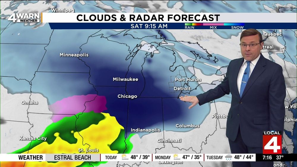
MORE SNOW AHEAD?? It's possible! Most of the major models support another system moving through the region for both Saturday and next Sunday. With the colder air in place with lows into the 20s and highs next Saturday right around freezing, we are putting snow in the forecast (for now) on Saturday..
November 23, 2025 at 8:40 PM
MORE SNOW AHEAD?? It's possible! Most of the major models support another system moving through the region for both Saturday and next Sunday. With the colder air in place with lows into the 20s and highs next Saturday right around freezing, we are putting snow in the forecast (for now) on Saturday..
THANKSGIVING THURSDAY: With a northwesterly flow kicking in behind that front & low pressure center, we will bring in the chance of some snow showers thanks to the lake-effect snow machine kicking in! So, if you're joining us for the parade, don't be surprised to see some snowflakes! #MIWX

November 23, 2025 at 7:40 PM
THANKSGIVING THURSDAY: With a northwesterly flow kicking in behind that front & low pressure center, we will bring in the chance of some snow showers thanks to the lake-effect snow machine kicking in! So, if you're joining us for the parade, don't be surprised to see some snowflakes! #MIWX
WEDNESDAY (TRAVEL DAY) FORECAST: Once that cold front moves through, we will keep the chance of rain showers in the forecast for the middle of the week. Moisture will wrap around the area of low pressure as it moves East, so we'll hold onto the umbrella by the time we get to Wednesday.. #MIWX

November 23, 2025 at 6:40 PM
WEDNESDAY (TRAVEL DAY) FORECAST: Once that cold front moves through, we will keep the chance of rain showers in the forecast for the middle of the week. Moisture will wrap around the area of low pressure as it moves East, so we'll hold onto the umbrella by the time we get to Wednesday.. #MIWX
Here comes the changes to the forecast, with a busy forecast looking ahead into Thanksgiving! Clouds increase Monday afternoon/evening, and rain showers move into the region, looking ahead into Tuesday. That cold front moves through by Tuesday afternoon/evening.. #MIWX

November 23, 2025 at 5:40 PM
Here comes the changes to the forecast, with a busy forecast looking ahead into Thanksgiving! Clouds increase Monday afternoon/evening, and rain showers move into the region, looking ahead into Tuesday. That cold front moves through by Tuesday afternoon/evening.. #MIWX
A nice view over Detroit Metro Airport earlier this morning before sunrise! Most of the region starts off in the 30s as you're waking up, wind chills are in the upper 20s and lower 30s for everyone as well. Temperatures will get warmer into the afternoon thanks to the Southwesterly flow & sunshine!

November 23, 2025 at 4:40 PM
A nice view over Detroit Metro Airport earlier this morning before sunrise! Most of the region starts off in the 30s as you're waking up, wind chills are in the upper 20s and lower 30s for everyone as well. Temperatures will get warmer into the afternoon thanks to the Southwesterly flow & sunshine!
WEATHER HEADLINES: The sunshine for the end of the weekend is topping my weather headlines this Sunday morning. Enjoy the dry weather, because it gets active pretty fast! Rain showers move in before colder weather, and chances for snow are in the forecast next week.. #MIWX

November 23, 2025 at 3:40 PM
WEATHER HEADLINES: The sunshine for the end of the weekend is topping my weather headlines this Sunday morning. Enjoy the dry weather, because it gets active pretty fast! Rain showers move in before colder weather, and chances for snow are in the forecast next week.. #MIWX
WEATHER IMPACTS: We're good for today and into Monday, but then the rain moves into the region just in time for one of the busiest travel days heading into the holidays for Thanksgiving. Once the rain moves out, brace yourself... we're getting colder with some snow in the forecast.. #MIWX

November 23, 2025 at 2:40 PM
WEATHER IMPACTS: We're good for today and into Monday, but then the rain moves into the region just in time for one of the busiest travel days heading into the holidays for Thanksgiving. Once the rain moves out, brace yourself... we're getting colder with some snow in the forecast.. #MIWX
SUNDAY FORECAST: We will keep the sunshine around as we work throughout the entire day on Sunday. Expect the breezy winds to stick around through the day as well. 30s out the door this morning, 40s by lunchtime, heading into the 50s by this afternoon! #MIWX

November 23, 2025 at 1:40 PM
SUNDAY FORECAST: We will keep the sunshine around as we work throughout the entire day on Sunday. Expect the breezy winds to stick around through the day as well. 30s out the door this morning, 40s by lunchtime, heading into the 50s by this afternoon! #MIWX
Back in the studio this morning with Priya and Jay, as we talk about Lions Tailgating and Game Day for this Sunday! We will keep the sunshine around, with temperatures warmer this afternoon than they were to start the weekend on Saturday! #MIWX #WeekendMornings

November 23, 2025 at 1:10 PM
Back in the studio this morning with Priya and Jay, as we talk about Lions Tailgating and Game Day for this Sunday! We will keep the sunshine around, with temperatures warmer this afternoon than they were to start the weekend on Saturday! #MIWX #WeekendMornings
SUNDAY SUNSHINE: As we're heading towards sunrise this morning, it is another cold start, but we as running warmer this morning than we were on Saturday morning. 30s out the door, 5-10 degrees warmer, and that warming trend continues into the afternoon! #MIWX


November 23, 2025 at 12:36 PM
SUNDAY SUNSHINE: As we're heading towards sunrise this morning, it is another cold start, but we as running warmer this morning than we were on Saturday morning. 30s out the door, 5-10 degrees warmer, and that warming trend continues into the afternoon! #MIWX
Just had to share this beautiful sky as we pass sunset this evening over at Detroit Metro Airport! A nice orange glow in the sky after we had an absolutely beautiful day on Monday!! #MIWX #4WarnWeather

November 17, 2025 at 10:39 PM
Just had to share this beautiful sky as we pass sunset this evening over at Detroit Metro Airport! A nice orange glow in the sky after we had an absolutely beautiful day on Monday!! #MIWX #4WarnWeather
BUS STOP FORECAST: Mainly clear skies overnight tonight and into tomorrow morning. Expect 20s out the door, and we warm into the 40s by the time we get to the afternoon, with plenty of sunshine for most of the day. Expect the clouds to increase late Monday night... #MIWX

November 17, 2025 at 12:10 AM
BUS STOP FORECAST: Mainly clear skies overnight tonight and into tomorrow morning. Expect 20s out the door, and we warm into the 40s by the time we get to the afternoon, with plenty of sunshine for most of the day. Expect the clouds to increase late Monday night... #MIWX
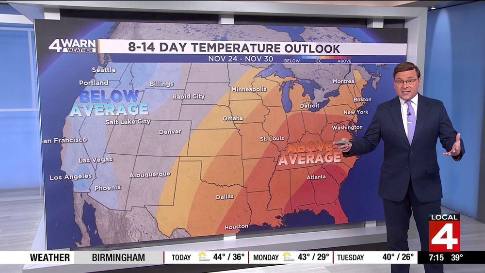
WARMER CHANGES AHEAD: Looks like we warm things up heading into #Thanksgiving! The Climate Prediction Center's 8-14 Day Temperature Outlook brings above-average temperatures into the Eastern 1/2 of the United States. So, we might be able to stay above freezing next week.. #MIWX
November 16, 2025 at 9:10 PM
WARMER CHANGES AHEAD: Looks like we warm things up heading into #Thanksgiving! The Climate Prediction Center's 8-14 Day Temperature Outlook brings above-average temperatures into the Eastern 1/2 of the United States. So, we might be able to stay above freezing next week.. #MIWX
FRIDAY RAINFALL: Friday (as of right now) looks to be a washout. Not the news we want to hear for our tree lighting ceremony Friday night in Downtown Detroit. This is 5:45 PM Friday, widespread moderate rainfall is expected. We'll continue to fine-tune this forecast throughout the week.. #MIWX

November 16, 2025 at 8:10 PM
FRIDAY RAINFALL: Friday (as of right now) looks to be a washout. Not the news we want to hear for our tree lighting ceremony Friday night in Downtown Detroit. This is 5:45 PM Friday, widespread moderate rainfall is expected. We'll continue to fine-tune this forecast throughout the week.. #MIWX
We keep the cloud cover in for Wednesday before the bigger chance of rain moves into the region for the end of next week. Rain showers are expected to move back into the region by late Thursday afternoon and into Thursday evening. Rain sticks around into the end of the week as well.. #MIWX

November 16, 2025 at 7:10 PM
We keep the cloud cover in for Wednesday before the bigger chance of rain moves into the region for the end of next week. Rain showers are expected to move back into the region by late Thursday afternoon and into Thursday evening. Rain sticks around into the end of the week as well.. #MIWX