


Brian McNoldy
@bmcnoldy.bsky.social
Univ. of Miami hurricane researcher 🌀 living in New Mexico 🏜.
Husband and dog dad. 🏳️🌈
https://bmcnoldy.earth.miami.edu/
Husband and dog dad. 🏳️🌈
https://bmcnoldy.earth.miami.edu/
Rocco after a haircut... sweater, blankie, and a fire to stay cozy.

November 22, 2025 at 1:05 AM
Rocco after a haircut... sweater, blankie, and a fire to stay cozy.
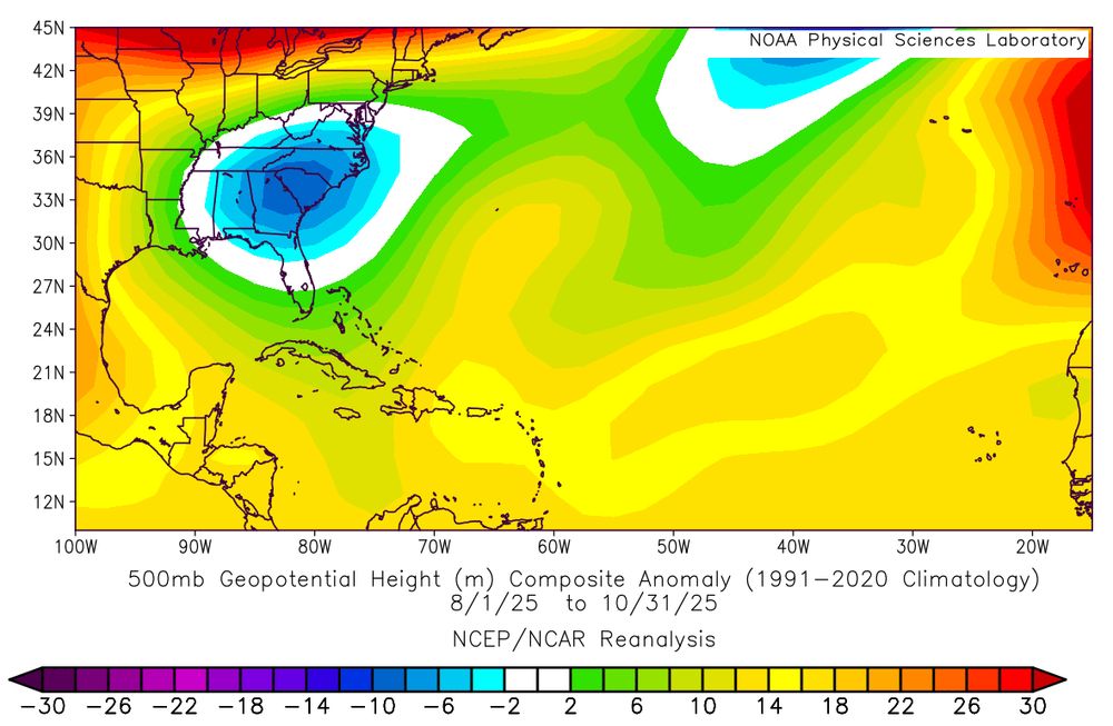
On the same scale as the original (+/- 30 m):

November 18, 2025 at 8:57 PM
On the same scale as the original (+/- 30 m):
During the core months of hurricane season (Aug-Sep-Oct), fairly persistent anomalous "troughiness" was centered over the southeast U.S., which resulted in anomalous counter-clockwise steering flow around it.
This helps explain why hurricanes generally turned northward well before reaching the U.S.
This helps explain why hurricanes generally turned northward well before reaching the U.S.

November 18, 2025 at 8:36 PM
During the core months of hurricane season (Aug-Sep-Oct), fairly persistent anomalous "troughiness" was centered over the southeast U.S., which resulted in anomalous counter-clockwise steering flow around it.
This helps explain why hurricanes generally turned northward well before reaching the U.S.
This helps explain why hurricanes generally turned northward well before reaching the U.S.
It is also quite possible that 2025 will set a new record for the latest first freeze. There has still not been a freezing temperature this Fall, and none are in the seven-day forecast. The current record latest is November 22.
[2/2]
[2/2]

November 17, 2025 at 6:00 PM
It is also quite possible that 2025 will set a new record for the latest first freeze. There has still not been a freezing temperature this Fall, and none are in the seven-day forecast. The current record latest is November 22.
[2/2]
[2/2]
With just two weeks remaining in meteorological Fall (Sep-Oct-Nov), it still looks like this will be the warmest Fall in #Albuquerque 's 133-year-long record. The current warmest had an average temperature of 61.5° (2024), and this year may come in around 62.0°F.
[1/2]
[1/2]

November 17, 2025 at 6:00 PM
With just two weeks remaining in meteorological Fall (Sep-Oct-Nov), it still looks like this will be the warmest Fall in #Albuquerque 's 133-year-long record. The current warmest had an average temperature of 61.5° (2024), and this year may come in around 62.0°F.
[1/2]
[1/2]
5 years ago today:
Hurricane season was likely over this year before November, but that's not always the case... Iota was the 30th and strongest named storm of the 2020 season. It was an upper-end Category 4 hurricane (operationally it was a Category 5, but downgraded in the post-season reanalysis).
Hurricane season was likely over this year before November, but that's not always the case... Iota was the 30th and strongest named storm of the 2020 season. It was an upper-end Category 4 hurricane (operationally it was a Category 5, but downgraded in the post-season reanalysis).
November 16, 2025 at 1:05 PM
5 years ago today:
Hurricane season was likely over this year before November, but that's not always the case... Iota was the 30th and strongest named storm of the 2020 season. It was an upper-end Category 4 hurricane (operationally it was a Category 5, but downgraded in the post-season reanalysis).
Hurricane season was likely over this year before November, but that's not always the case... Iota was the 30th and strongest named storm of the 2020 season. It was an upper-end Category 4 hurricane (operationally it was a Category 5, but downgraded in the post-season reanalysis).
Furthermore, it will also very likely be the warmest Fall on record (Sep-Oct-Nov) here. I'm projecting a Fall-average of around 62.0°F. The current record warmest is 2024 at 61.5°F.
[2/2]
[2/2]

November 16, 2025 at 12:20 AM
Furthermore, it will also very likely be the warmest Fall on record (Sep-Oct-Nov) here. I'm projecting a Fall-average of around 62.0°F. The current record warmest is 2024 at 61.5°F.
[2/2]
[2/2]
This has been the warmest first half of November on record in #Albuquerque, by a hefty 1.5°F margin. The average temperature was 56.9°F, compared to the 1991-2020 average of 49.0°F.
[1/2]
[1/2]

November 16, 2025 at 12:20 AM
This has been the warmest first half of November on record in #Albuquerque, by a hefty 1.5°F margin. The average temperature was 56.9°F, compared to the 1991-2020 average of 49.0°F.
[1/2]
[1/2]


#Albuquerque still has not hit the freezing mark (32°F) yet this season, and today is the 90th percentile date for first freeze -- meaning that the first freeze has occurred in 90% of years by now.
[1/2]
[1/2]
November 11, 2025 at 12:36 PM
#Albuquerque still has not hit the freezing mark (32°F) yet this season, and today is the 90th percentile date for first freeze -- meaning that the first freeze has occurred in 90% of years by now.
[1/2]
[1/2]
With the first nine days of November in the books, and the unseasonably warm days ahead, the first two weeks of November will end up the warmest on record in #Albuquerque, going back to 1892.
The exact value for 2025 will come into focus day by day, but should be very close to 56.0°F. Stay tuned!
The exact value for 2025 will come into focus day by day, but should be very close to 56.0°F. Stay tuned!


November 10, 2025 at 4:38 PM
With the first nine days of November in the books, and the unseasonably warm days ahead, the first two weeks of November will end up the warmest on record in #Albuquerque, going back to 1892.
The exact value for 2025 will come into focus day by day, but should be very close to 56.0°F. Stay tuned!
The exact value for 2025 will come into focus day by day, but should be very close to 56.0°F. Stay tuned!
The first week of November was the warmest on record in #Albuquerque by a big margin.
The average temperature from Nov 1-7 was 59.0°F, cruising well above the previous record of 57.8°F set in 2020. Records go back to 1892.
I also plotted the trend line, and *shocker*, it's been warming!
The average temperature from Nov 1-7 was 59.0°F, cruising well above the previous record of 57.8°F set in 2020. Records go back to 1892.
I also plotted the trend line, and *shocker*, it's been warming!

November 7, 2025 at 10:15 PM
The first week of November was the warmest on record in #Albuquerque by a big margin.
The average temperature from Nov 1-7 was 59.0°F, cruising well above the previous record of 57.8°F set in 2020. Records go back to 1892.
I also plotted the trend line, and *shocker*, it's been warming!
The average temperature from Nov 1-7 was 59.0°F, cruising well above the previous record of 57.8°F set in 2020. Records go back to 1892.
I also plotted the trend line, and *shocker*, it's been warming!
Here is this year's closest full moon setting above our house... taken just one hour before it's technically 100% full (which is at 6:19am MST), but still above the horizon.
This was taken at 5:19am. It'll have to do for a quick phone photo.
#supermoon #newmexico
This was taken at 5:19am. It'll have to do for a quick phone photo.
#supermoon #newmexico

November 5, 2025 at 12:39 PM
Here is this year's closest full moon setting above our house... taken just one hour before it's technically 100% full (which is at 6:19am MST), but still above the horizon.
This was taken at 5:19am. It'll have to do for a quick phone photo.
#supermoon #newmexico
This was taken at 5:19am. It'll have to do for a quick phone photo.
#supermoon #newmexico
My attempt at photos (from my phone) of this year's largest, closest, and brightest full moon.
#supermoon
#supermoon


November 5, 2025 at 12:39 AM
My attempt at photos (from my phone) of this year's largest, closest, and brightest full moon.
#supermoon
#supermoon
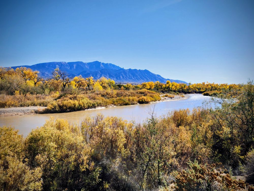
A few Fall shots of the Rio Grande and Sandias from my neighborhood in Bernalillo...


November 4, 2025 at 12:21 PM
A few Fall shots of the Rio Grande and Sandias from my neighborhood in Bernalillo...
Denver is pretty similar, but SLC has some notable differences.


November 3, 2025 at 4:31 PM
Denver is pretty similar, but SLC has some notable differences.
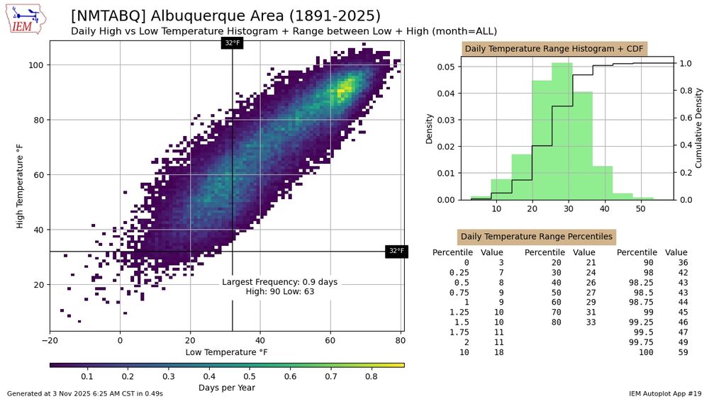
This "weathergami" plot for #Albuquerque is interesting. The plot shows the historical frequency of daily high and low temperature combinations. What's curious is the peak with ~90°F highs and ~63°F lows... that is the most common type of day here apparently.
November 3, 2025 at 12:40 PM
This "weathergami" plot for #Albuquerque is interesting. The plot shows the historical frequency of daily high and low temperature combinations. What's curious is the peak with ~90°F highs and ~63°F lows... that is the most common type of day here apparently.
The average water level measured at Virginia Key (near #Miami) set a new monthly record high in October, which is also the new *all-time* record high month.
I also feel confident that it was the highest monthly water level there since the last interglacial period... ~120,000 years ago.
🤯🌊🧪
I also feel confident that it was the highest monthly water level there since the last interglacial period... ~120,000 years ago.
🤯🌊🧪


November 2, 2025 at 1:12 PM
The average water level measured at Virginia Key (near #Miami) set a new monthly record high in October, which is also the new *all-time* record high month.
I also feel confident that it was the highest monthly water level there since the last interglacial period... ~120,000 years ago.
🤯🌊🧪
I also feel confident that it was the highest monthly water level there since the last interglacial period... ~120,000 years ago.
🤯🌊🧪

Quick run of my parametric wind swath model on a small portion of Melissa's track. All storm parameters (track, intensity, size) come from the working "best-track", and I simply reduce wind speeds over land by a uniform 30%.
Not perfect, but it's something.
Not perfect, but it's something.

October 31, 2025 at 11:45 PM
Quick run of my parametric wind swath model on a small portion of Melissa's track. All storm parameters (track, intensity, size) come from the working "best-track", and I simply reduce wind speeds over land by a uniform 30%.
Not perfect, but it's something.
Not perfect, but it's something.
I thought that too, but the Azores High has been pretty "average" over the past 3 months, both in position and pressure.
October 31, 2025 at 10:14 PM
I thought that too, but the Azores High has been pretty "average" over the past 3 months, both in position and pressure.
With one month to go in the hurricane season, here's a track map showing the activity so far: 13 named storms, including an extraordinary *3* Category 5 hurricanes.

October 31, 2025 at 9:55 PM
With one month to go in the hurricane season, here's a track map showing the activity so far: 13 named storms, including an extraordinary *3* Category 5 hurricanes.
Slow-moving Hurricane #Melissa managed to cool the extremely-anomalously-warm central Caribbean Sea down to right around average for the date. Instead of a "cold wake", would that be an "average wake"? 😉
[1/2]
[1/2]
October 31, 2025 at 8:15 PM
Slow-moving Hurricane #Melissa managed to cool the extremely-anomalously-warm central Caribbean Sea down to right around average for the date. Instead of a "cold wake", would that be an "average wake"? 😉
[1/2]
[1/2]
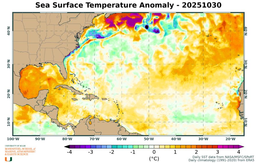
The water temperature in the Gulf of Mexico and the western Caribbean Sea is VERY warm for this time of year.
This could become relevant because the western Caribbean is climatologically a key spot to watch for development in November (November Caribbean hurricanes: bit.ly/4oB9Kjz).
This could become relevant because the western Caribbean is climatologically a key spot to watch for development in November (November Caribbean hurricanes: bit.ly/4oB9Kjz).

October 31, 2025 at 4:23 PM
The water temperature in the Gulf of Mexico and the western Caribbean Sea is VERY warm for this time of year.
This could become relevant because the western Caribbean is climatologically a key spot to watch for development in November (November Caribbean hurricanes: bit.ly/4oB9Kjz).
This could become relevant because the western Caribbean is climatologically a key spot to watch for development in November (November Caribbean hurricanes: bit.ly/4oB9Kjz).
The Accumulated Cyclone Energy (ACE) is at 114% of average for the date, and *if* nothing else forms in the remainder of hurricane season, the 2025 season would end up at 108% of average. The last few years with lower ACE were 2022, 2015, 2014, and 2013, and 2009.
[3/3]
[3/3]

October 31, 2025 at 4:04 PM
The Accumulated Cyclone Energy (ACE) is at 114% of average for the date, and *if* nothing else forms in the remainder of hurricane season, the 2025 season would end up at 108% of average. The last few years with lower ACE were 2022, 2015, 2014, and 2013, and 2009.
[3/3]
[3/3]