


Benedikt Straňák
@benediktstranak.bsky.social
Researcher interested in rent, finance and political economy of land. Numerate, immigrant and queer. 🇵🇸🇺🇦🏳️🌈🏳️⚧️ Views my own.
👨🏻💻 Centre for Local Economic Strategies (CLES), previously New Economics Foundation.
👨🏻💻 Centre for Local Economic Strategies (CLES), previously New Economics Foundation.
Today's news: www.theguardian.com/politics/202... 5/5

Rachel Reeves to announce billions in regional spending after Treasury rule changes
Extra investment lined up for schemes such as energy projects, roads and rails outside London and south-east
www.theguardian.com
May 30, 2025 at 1:57 PM
Today's news: www.theguardian.com/politics/202... 5/5
Curious to see any details of the investment plans: how much, what in, where, and how. More public investment outside of London is a a good start, but by no means a guarantee of a meaningful, positive difference to people's lives (read the report!). 4/5
May 30, 2025 at 1:57 PM
Curious to see any details of the investment plans: how much, what in, where, and how. More public investment outside of London is a a good start, but by no means a guarantee of a meaningful, positive difference to people's lives (read the report!). 4/5
The report includes figures for every local authority, so you can look up your area! There’s also a detailed methodology if you want to understand how we got to these numbers. 3/5
May 30, 2025 at 1:57 PM
The report includes figures for every local authority, so you can look up your area! There’s also a detailed methodology if you want to understand how we got to these numbers. 3/5
With Emmet Kiberd, we estimate that outside of London, England faces an annual public investment gap of £15.6bn in transport and active travel infrastructure. £11.8bn in social housing. £3.4bn in housing retrofit. £1.4bn in local energy. East Midlands needs the most investment. 2/5
May 30, 2025 at 1:57 PM
With Emmet Kiberd, we estimate that outside of London, England faces an annual public investment gap of £15.6bn in transport and active travel infrastructure. £11.8bn in social housing. £3.4bn in housing retrofit. £1.4bn in local energy. East Midlands needs the most investment. 2/5
Reposted by Benedikt Straňák

We'd urge people not to panic - there will be lots of commentary coming out quickly that is likely to deliberately overstate the impact that this decision is going to have on all trans people's lives. We'll say more as soon as we're able to. Please look out for yourselves and each other today 💗🏳️⚧️
April 16, 2025 at 9:00 AM
We'd urge people not to panic - there will be lots of commentary coming out quickly that is likely to deliberately overstate the impact that this decision is going to have on all trans people's lives. We'll say more as soon as we're able to. Please look out for yourselves and each other today 💗🏳️⚧️
The data on travel times is particularly interesting, published by @ubdc.bsky.social at University of Glasgow. And all of the data we used is freely accessible, including the map layers (OS Open Zoomstack) 4/4 data.ubdc.ac.uk/datasets/acc...

Great Britain Accessibility Indicators 2023 (AI23) - UBDC Data Catalogue
Accessibility indicators measure the ease of reaching valuable destinations (Levinson and Wu 2020). The
current dataset, Great Britain Accessibility Indicators 2023 (AI23), provides small-area...
data.ubdc.ac.uk
November 19, 2024 at 11:43 AM
The data on travel times is particularly interesting, published by @ubdc.bsky.social at University of Glasgow. And all of the data we used is freely accessible, including the map layers (OS Open Zoomstack) 4/4 data.ubdc.ac.uk/datasets/acc...
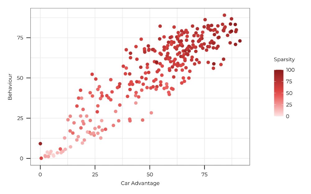
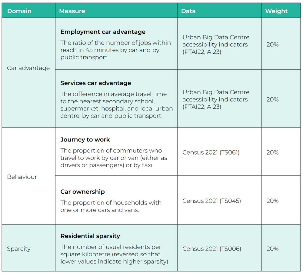
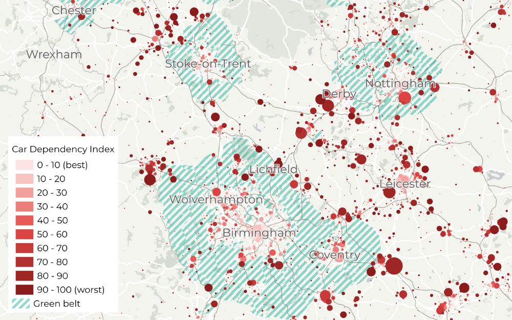
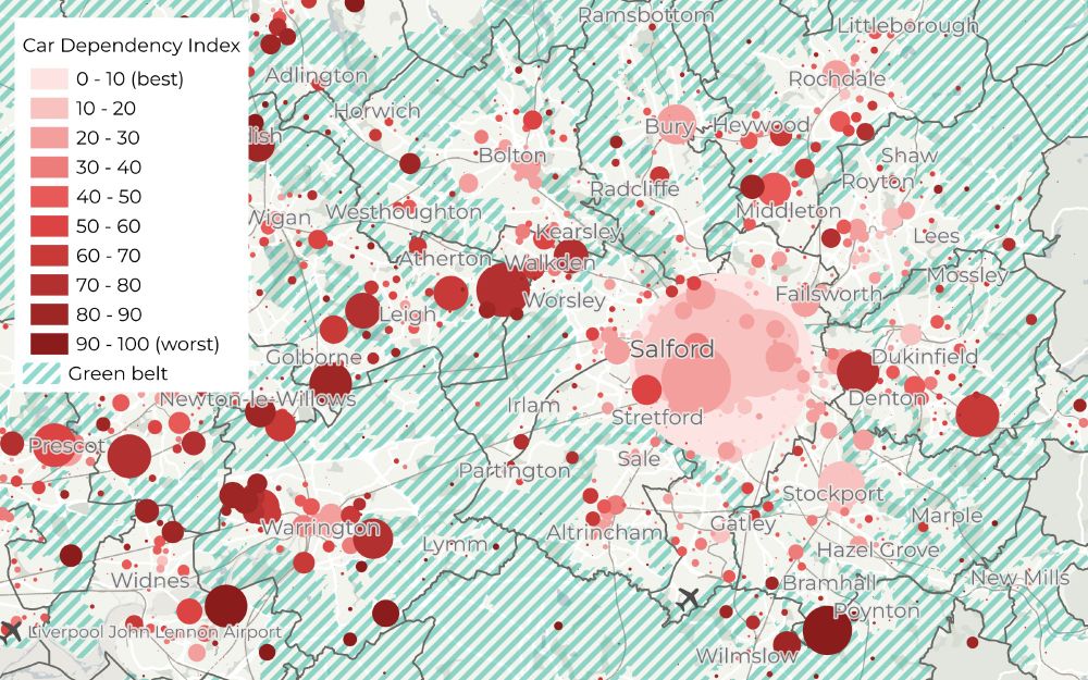
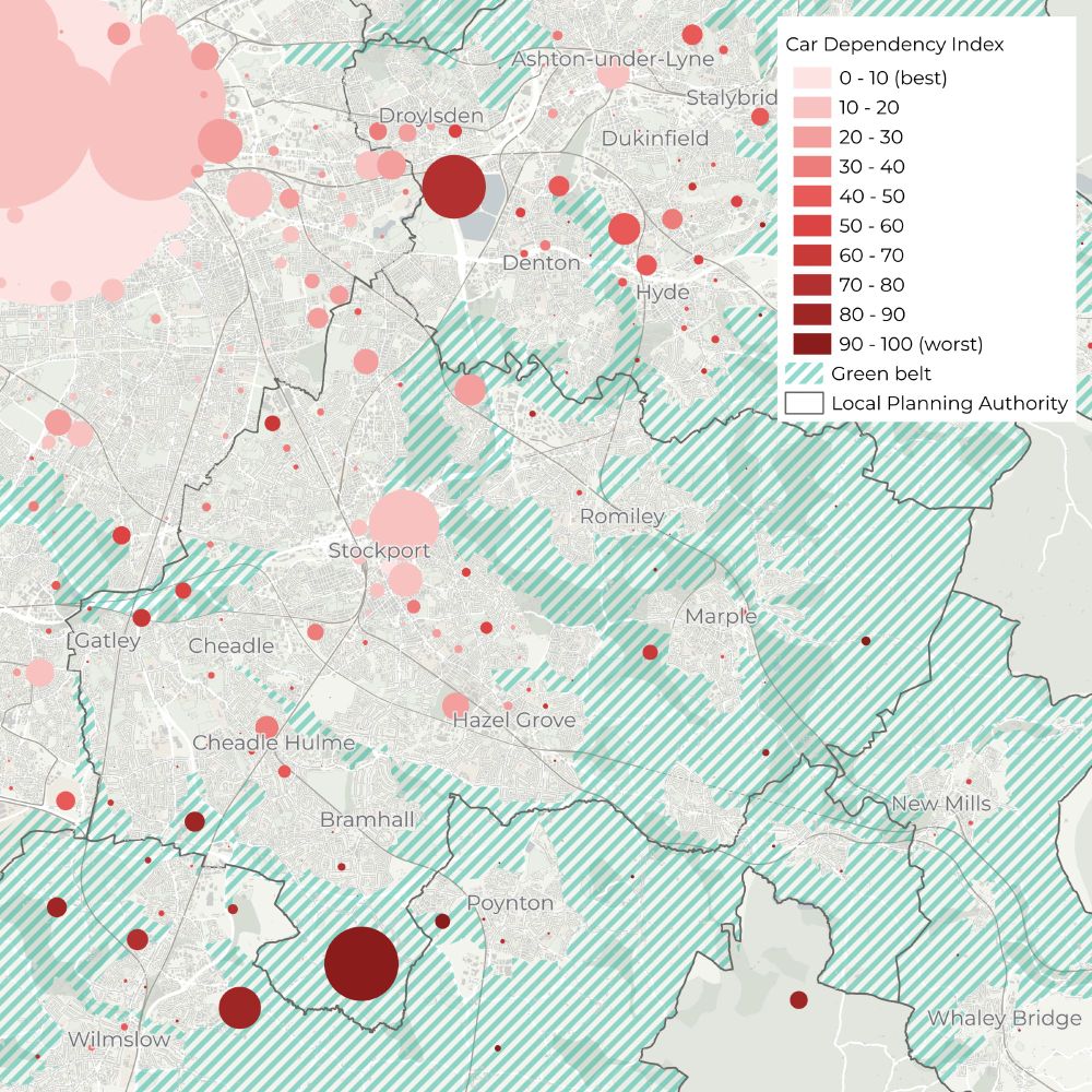
For car dependency, we construct a detailed spatial index from data on travel times (by car and public transport) to schools, supermarkets, hospitals, town centres and employment, and Census data on density, car ownership, and transport mode used to travel to work. 3/4
November 19, 2024 at 11:43 AM
For car dependency, we construct a detailed spatial index from data on travel times (by car and public transport) to schools, supermarkets, hospitals, town centres and employment, and Census data on density, car ownership, and transport mode used to travel to work. 3/4
For locations of new homes, we use data from the open EPC register. Each new home in England gets an EPC rating which is logged in a public register. The register contains Unique Property Reference Numbers (UPRNs) that can be used to geolocate the new dwellings. 2/4 epc.opendatacommunities.org
Energy Performance of Buildings Data England and Wales
epc.opendatacommunities.org
November 19, 2024 at 11:43 AM
For locations of new homes, we use data from the open EPC register. Each new home in England gets an EPC rating which is logged in a public register. The register contains Unique Property Reference Numbers (UPRNs) that can be used to geolocate the new dwellings. 2/4 epc.opendatacommunities.org
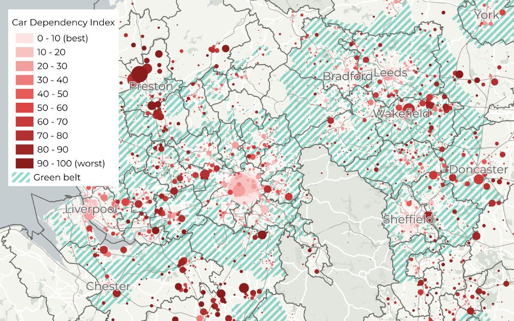
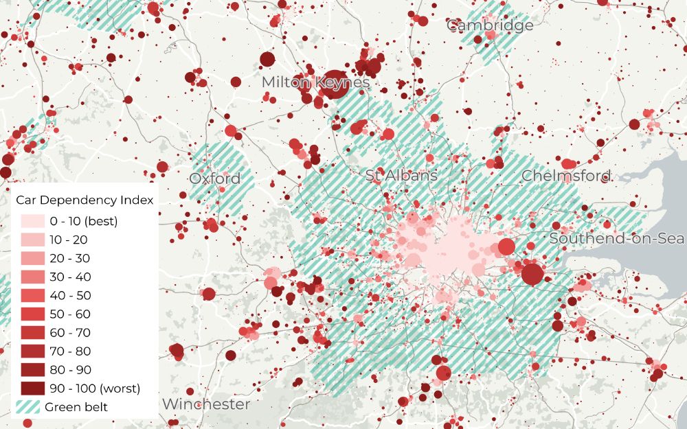
Indeed, but sadly not unique in that respect. This is how the Northern Conurbation compares to Midlands, and to London and its surrounds ...
November 18, 2024 at 9:55 PM
Indeed, but sadly not unique in that respect. This is how the Northern Conurbation compares to Midlands, and to London and its surrounds ...
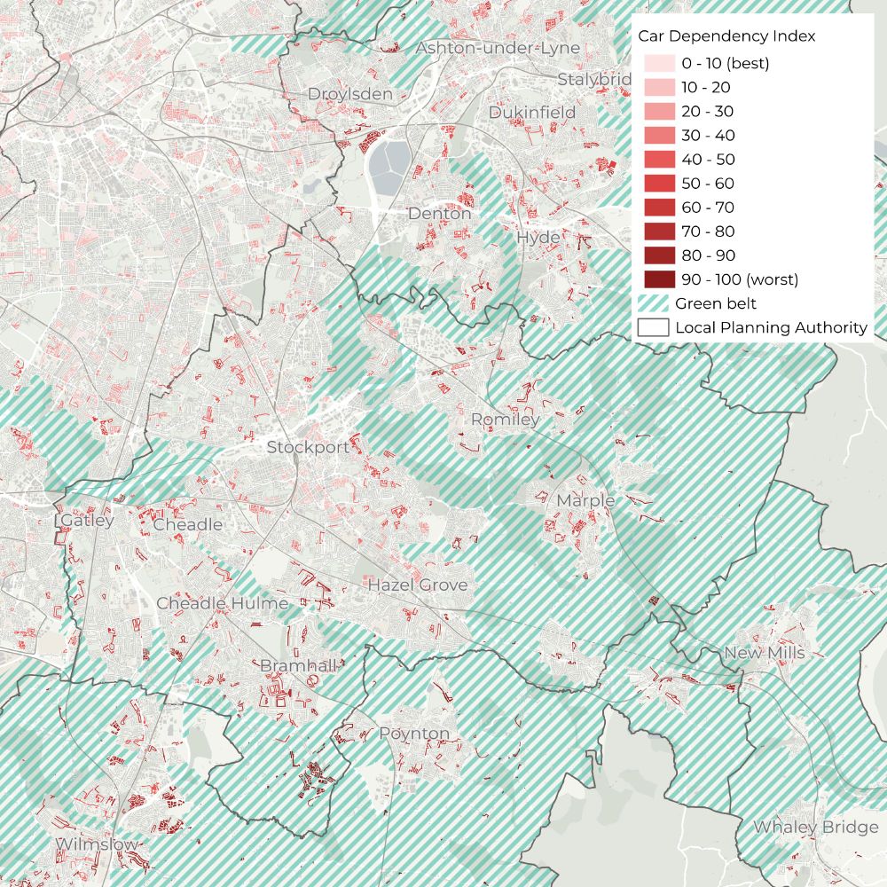
Here! Stockport, and most of Greater Manchester in the zoomed out map
November 18, 2024 at 9:26 PM
Here! Stockport, and most of Greater Manchester in the zoomed out map
Beam Park railway station - Wikipedia
en.m.wikipedia.org
November 18, 2024 at 4:06 PM
Hi! There were two parts to the research: the first part was data-intensive: we assessed car dependency of all places (LSOAs, small statistical areas) and looked at where exactly new homes are being build, across England. But to understand why this happens, we then spoke to planners, developers …
November 18, 2024 at 3:18 PM
Hi! There were two parts to the research: the first part was data-intensive: we assessed car dependency of all places (LSOAs, small statistical areas) and looked at where exactly new homes are being build, across England. But to understand why this happens, we then spoke to planners, developers …
Hi! There isn’t - it would be great, just don’t have the time and means at the moment. Happy to share exports for any places of interest.
November 18, 2024 at 3:08 PM
Hi! There isn’t - it would be great, just don’t have the time and means at the moment. Happy to share exports for any places of interest.