


Brad Barrett
@barrett-weather.bsky.social
Atmosphere-ocean-cryosphere; Extreme events; Teleconnections; 🌪️🌀❄️🇲🇽🇨🇱🇧🇧🇦🇹
PhD OU; Full Prof Oceanography USNA; Prog Officer AFOSF; CCM; Fulbright scholar; Bilingüe
PhD OU; Full Prof Oceanography USNA; Prog Officer AFOSF; CCM; Fulbright scholar; Bilingüe
The low-end severe risk over Oregon is evolving as expected


November 5, 2025 at 11:16 PM
The low-end severe risk over Oregon is evolving as expected
Today’s severe risk in OR and CA is very similar to the setups that we have found to favor tornadoes in Chile 🇨🇱 w/HSLC
doi.org/10.1016/j.at...
doi.org/10.1175/MWR-...
doi.org/10.1175/BAMS...
doi.org/10.1016/j.at...
doi.org/10.1175/MWR-...
doi.org/10.1175/BAMS...


November 5, 2025 at 6:17 PM
Today’s severe risk in OR and CA is very similar to the setups that we have found to favor tornadoes in Chile 🇨🇱 w/HSLC
doi.org/10.1016/j.at...
doi.org/10.1175/MWR-...
doi.org/10.1175/BAMS...
doi.org/10.1016/j.at...
doi.org/10.1175/MWR-...
doi.org/10.1175/BAMS...

November 5, 2025 at 5:17 AM
Again, don’t discount the role of multidecadal variability in explaining the trends you present
Figures are from Goldenberg et al 2001 (Science) and text from a CSU seasonal outlook c. 2000
doi.org/10.1126/scie...
Figures are from Goldenberg et al 2001 (Science) and text from a CSU seasonal outlook c. 2000
doi.org/10.1126/scie...


October 31, 2025 at 3:44 AM
Again, don’t discount the role of multidecadal variability in explaining the trends you present
Figures are from Goldenberg et al 2001 (Science) and text from a CSU seasonal outlook c. 2000
doi.org/10.1126/scie...
Figures are from Goldenberg et al 2001 (Science) and text from a CSU seasonal outlook c. 2000
doi.org/10.1126/scie...
Great animation and annotations. I admit this sort of merger was new for me. @btangywx.bsky.social and I tried to identify scndry wind mx in the recon reports (see ex blw). I was surprised to see them disappear so readily, as I thought theory almost requires an ERC once they formed. Thoughts?

October 30, 2025 at 2:26 PM
Great animation and annotations. I admit this sort of merger was new for me. @btangywx.bsky.social and I tried to identify scndry wind mx in the recon reports (see ex blw). I was surprised to see them disappear so readily, as I thought theory almost requires an ERC once they formed. Thoughts?
Is there a “standard”? 90%? I think I’ve seen everything from 70-110%, usually supported by other data
I was curious about these numbers I saw on Alex’s graphics this morning, eg
I was curious about these numbers I saw on Alex’s graphics this morning, eg

October 27, 2025 at 5:32 PM
Is there a “standard”? 90%? I think I’ve seen everything from 70-110%, usually supported by other data
I was curious about these numbers I saw on Alex’s graphics this morning, eg
I was curious about these numbers I saw on Alex’s graphics this morning, eg
While not explicitly mentioned by NHC, an outflow channel is becoming well established to the north of #Melissa, and this mass evacuation aloft will help with RI over the next 48 h
October 25, 2025 at 10:01 PM
While not explicitly mentioned by NHC, an outflow channel is becoming well established to the north of #Melissa, and this mass evacuation aloft will help with RI over the next 48 h
Here it comes! 🍂
October 20, 2025 at 2:09 AM
Here it comes! 🍂
Who robbed the Louvre? Right answers only

October 20, 2025 at 2:07 AM
Who robbed the Louvre? Right answers only
Cool to see your name on the discussion, @drmetwatch.bsky.social, with the talented @pppapin.bsky.social !

September 5, 2025 at 4:39 PM
Cool to see your name on the discussion, @drmetwatch.bsky.social, with the talented @pppapin.bsky.social !
Thoughts and prayers
@climatologist49.bsky.social
@climatologist49.bsky.social

September 3, 2025 at 3:18 AM
Thoughts and prayers
@climatologist49.bsky.social
@climatologist49.bsky.social
Bit of a bifurcation in the track ensembles for Lorena EP12, with majority of EC members staying west, about 1/3 of the Google DeepMind ensembles into Baja California, and about half the GEFS members into Baja. Consequences for SW US rains
GEFS and DM members have trended more westward today, FWIW
GEFS and DM members have trended more westward today, FWIW


September 2, 2025 at 9:34 PM
Bit of a bifurcation in the track ensembles for Lorena EP12, with majority of EC members staying west, about 1/3 of the Google DeepMind ensembles into Baja California, and about half the GEFS members into Baja. Consequences for SW US rains
GEFS and DM members have trended more westward today, FWIW
GEFS and DM members have trended more westward today, FWIW
Any surf cams from Ocracoke? Or other beaches that are oriented more perpendicular to the mean swell vector?

August 20, 2025 at 2:19 PM
Any surf cams from Ocracoke? Or other beaches that are oriented more perpendicular to the mean swell vector?
It’s been a busy few months at the national centers! At least one of the convective (SPC) or rainfall (WPC) outlooks has been at Slight or higher since 21 April


August 19, 2025 at 12:16 AM
It’s been a busy few months at the national centers! At least one of the convective (SPC) or rainfall (WPC) outlooks has been at Slight or higher since 21 April
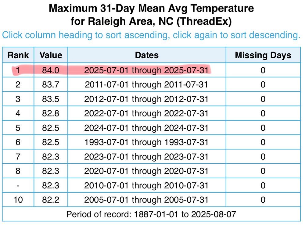
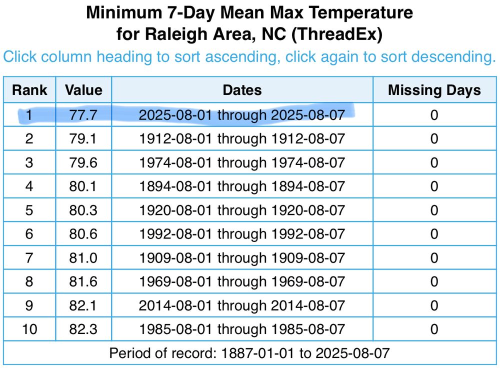
Congrats, Raleigh! After the warmest July on record 🥵 (since 1887), you followed up with the coldest high temps 🥶 on record for the first week of August!
August 8, 2025 at 11:13 PM
Congrats, Raleigh! After the warmest July on record 🥵 (since 1887), you followed up with the coldest high temps 🥶 on record for the first week of August!
I have some names that I’d like to call this current heatwave 🤬🥵
We just set the annual high temp at the house here in Garner, breaking the 102.4°F set back in late June. I fear that this new max (102.6°F) won’t last long….
We just set the annual high temp at the house here in Garner, breaking the 102.4°F set back in late June. I fear that this new max (102.6°F) won’t last long….

July 26, 2025 at 7:49 PM
I have some names that I’d like to call this current heatwave 🤬🥵
We just set the annual high temp at the house here in Garner, breaking the 102.4°F set back in late June. I fear that this new max (102.6°F) won’t last long….
We just set the annual high temp at the house here in Garner, breaking the 102.4°F set back in late June. I fear that this new max (102.6°F) won’t last long….
Td of 78.4°F (25.8°C) is a bit much considering we’re not coastal or next to a corn field (Garner NC, 7 SE of Raleigh and 100 miles inland from the Atlantic)
@gstephensonwx.bsky.social
@gstephensonwx.bsky.social

July 19, 2025 at 5:47 PM
Td of 78.4°F (25.8°C) is a bit much considering we’re not coastal or next to a corn field (Garner NC, 7 SE of Raleigh and 100 miles inland from the Atlantic)
@gstephensonwx.bsky.social
@gstephensonwx.bsky.social
Most of my scholarship has been at the level 3-4 level: case studies or composite averages. Every now and then I stumble into something that rises to level 2.
Fellow scholars, what about you?
Fellow scholars, what about you?

July 9, 2025 at 3:46 PM
Most of my scholarship has been at the level 3-4 level: case studies or composite averages. Every now and then I stumble into something that rises to level 2.
Fellow scholars, what about you?
Fellow scholars, what about you?

Compare this with insurance non renewals

July 2, 2025 at 4:52 PM
Compare this with insurance non renewals
The sea breeze is approaching KRAX, which is 100 miles inland!
@gstephensonwx.bsky.social
@wxcruzmedina.bsky.social
@gstephensonwx.bsky.social
@wxcruzmedina.bsky.social
June 11, 2025 at 9:47 PM
The sea breeze is approaching KRAX, which is 100 miles inland!
@gstephensonwx.bsky.social
@wxcruzmedina.bsky.social
@gstephensonwx.bsky.social
@wxcruzmedina.bsky.social
Classic cold-air damming event underway in the mid-Atlantic region today. Surface high ~1030 mb centered over Ontario with isentropic lift-driven precipitation and clouds reinforcing the cold pattern in the lee of the southern and central Appalachians
Temps in the mid 50s are about 25F below normal
Temps in the mid 50s are about 25F below normal


May 27, 2025 at 5:42 PM
Classic cold-air damming event underway in the mid-Atlantic region today. Surface high ~1030 mb centered over Ontario with isentropic lift-driven precipitation and clouds reinforcing the cold pattern in the lee of the southern and central Appalachians
Temps in the mid 50s are about 25F below normal
Temps in the mid 50s are about 25F below normal

MC had zero doubt the nocturnal tornado that damaged much of Plevna KS on May 18 was at EF-5 intensity. Of course, NWS ICT rated it (only) EF-3. I guess those 200+ mph winds were above the surface (actually plausible) or missed things
@stephenmstrader.bsky.social
@jladue.bsky.social
@stephenmstrader.bsky.social
@jladue.bsky.social

May 22, 2025 at 8:19 PM
MC had zero doubt the nocturnal tornado that damaged much of Plevna KS on May 18 was at EF-5 intensity. Of course, NWS ICT rated it (only) EF-3. I guess those 200+ mph winds were above the surface (actually plausible) or missed things
@stephenmstrader.bsky.social
@jladue.bsky.social
@stephenmstrader.bsky.social
@jladue.bsky.social